Importo totale (1 articolo articoli):
Destinazione ordine:

map canada (103 risultati)
Vai alla pagina principale dei risultati di ricerca
Filtri di ricerca
Tipo di articolo
- Tutti i tipi di prodotto
- Libri (40)
- Riviste e Giornali (1)
- Fumetti (Nessun altro risultato corrispondente a questo perfezionamento)
- Spartiti (Nessun altro risultato corrispondente a questo perfezionamento)
- Arte, Stampe e Poster (2)
- Fotografie (Nessun altro risultato corrispondente a questo perfezionamento)
- Mappe (60)
- Manoscritti e Collezionismo cartaceo (Nessun altro risultato corrispondente a questo perfezionamento)
Condizioni Maggiori informazioni
- Nuovo (13)
- Come nuovo, Ottimo o Quasi ottimo (Nessun altro risultato corrispondente a questo perfezionamento)
- Molto buono o Buono (22)
- Discreto o Mediocre (1)
- Come descritto (67)
Legatura
Ulteriori caratteristiche
- Prima ed. (12)
- Copia autograf. (1)
- Sovracoperta (Nessun altro risultato corrispondente a questo perfezionamento)
- Con foto (78)
- Non Print on Demand (92)
Lingua (2)
Spedizione gratuita
Paese del venditore
Valutazione venditore
-

INTO THE WILD
Lingua: Inglese
Editore: DOUBLEDAY, Anchor 1996,1997,feb, N. Y., 1996
ISBN 10: 0385486804 ISBN 13: 9780385486804
Da: WONDERFUL BOOKS BY MAIL, CHICO-CA, CA, U.S.A.
Valutazione del venditore 5 su 5 stelle

paperback. Condizione: Fair. Illustrated by USA, CANADA & alaska map. (illustratore). PAPERBACK; 9 10pt line. FAIR Condition PAPERBACK.HAS BOTTOM CORNER CLIPT & 3 INNER PAGES ALSO.rest of book is quite CLEAN, SOLID & bright; THIS COPY HAS THE PHOTO COVER .top half b&w photo of snow covered bus. INNER BACK COVER SHOWS LARGE PHOTO PORTRAIT OF AUTHOR ; DOULE PAGE map,PHOTO; 207+pg pages; Journalist explores the life and death of a young man who lost his life in the Alaska wilds. SNOW, BUT NO PESON ON ROOF OF FAIRBANKS BUS WITH GREY SKY COVER PHOTO.LARGE PHOTO OF AUTHOR next to old FAIRBANKS CITY bus front endpaper.
-
INTO THE WILD
Lingua: Inglese
Editore: DOUBLEDAY, Anchor 1996,1997,feb, N. Y., 1996
ISBN 10: 0385486804 ISBN 13: 9780385486804
Da: WONDERFUL BOOKS BY MAIL, CHICO-CA, CA, U.S.A.
Valutazione del venditore 5 su 5 stelle
paperback. Condizione: Very Good. Illustrated by USA, CANADA & alaska map. (illustratore). first THUS; 91pt line. VERY GOOD Condition PAPERBACK.CLEAN, SOLID, BRIGHT.; THIS COPY HAS THE EARLIER PHOTO COVER. ; DOULE PAGE map,PHOTO; 207+pg pages; Journalist explores the life and death of a young man who lost his life in the Alaska wilds. SNOW, BUT NO PESON ON ROOF OF FAIRBANKS BUS WITH GREY SKY COVER PHOTO.LARGE PHOTO OF AUTHOR next to old bus front endpaper.
-
INTO THE WILD
Lingua: Inglese
Editore: DOUBLEDAY, Anchor 1996,1997,feb, N. Y., 1996
ISBN 10: 0385486804 ISBN 13: 9780385486804
Da: WONDERFUL BOOKS BY MAIL, CHICO-CA, CA, U.S.A.
Valutazione del venditore 5 su 5 stelle
paperback. Condizione: Very Good. Illustrated by USA, CANADA & alaska map. (illustratore). first THUS; 27pt line. VERY GOOD Condition PAPERBACK.CLEAN, SOLID, BRIGHT.; THIS COPY HAS THE EARLIER PHOTO COVER. ; DOULE PAGE map,PHOTO; 207+pg pages; Journalist explores the life and death of a young man who lost his life in the Alaska wilds. SNOW, BUT NO PESON ON ROOF OF FAIRBANKS BUS WITH GREY SKY COVER PHOTO.LARGE PHOTO OF AUTHOR INNER BACK COVER.
-

Dictionary of Altitudes in the Dominion of Canada
Da: PBShop.store US, Wood Dale, IL, U.S.A.
Valutazione del venditore 5 su 5 stelle
PAP. Condizione: New. New Book. Shipped from UK. Established seller since 2000.
-
Dictionary of Altitudes in the Dominion of Canada
Da: PBShop.store UK, Fairford, GLOS, Regno Unito
Valutazione del venditore 5 su 5 stelle
EUR 22,33
Spedizione EUR 4,80
Spedito da Regno Unito a U.S.A.Quantit�: 15 disponibili
Aggiungi al carrelloPAP. Condizione: New. New Book. Shipped from UK. Established seller since 2000.
-

A Davenport Map of Greater Victoria with street index
Editore: Victoria : The Island Blue Print and Map Co., 1957
Revised Edition. Vintage fold-out colour map in a very good condition; edges slightly dust-dulled and nicked. Consists of a stiff-card wallet with the fold-out street index and map attached either side of the inside covers. Remains particularly and surprisingly well-preserved overall; tight, bright, clean and especially sharp-cornered. ; 8vo 8" - 9" tall; 1 pages; Description: 1 fold-out colour map ; 23 x 10cm (folded). Subjects: Victoria, Canada -- Map -- Maps -- Street plan -- Description and travel -- Cartographic material. 3 Kg.
-

The National Geographic Magazine. June, 1959 / Robert Leslie Conly and Erich Lessing "Modern Miracle, made in Germany" / Paul A Zahl "Volcanic Fires of the 50th state: Hawaii National Park" / Phyllis Wilson and Kathleen Revis " Queen of Canada" / Geographic photographers win top awards / John T Cunningham, Jay Johnston and W D Vaughn "Staten Island ferry, New York's seagoing bus" / Nathaniel T Kenney and William Belknap Jr "Where falcons wear Air Force blue" / New atlas map charts a Germany divided.
Editore: The National Geographic Society, 1959
Rivista / Giornale
EUR 9,51
Spedizione EUR 12,70
Spedito da Regno Unito a U.S.A.Quantit�: 2 disponibili
Aggiungi al carrelloSoft cover. Condizione: Good. Robert Leslie Conly and Erich Lessing "Modern Miracle, made in Germany" / Paul A Zahl "Volcanic Fires of the 50th state: Hawaii National Park" / Phyllis Wilson and Kathleen Revis " Queen of Canada" / Geographic photographers win top awards / John T Cunningham, Jay Johnston and W D Vaughn "Staten Island ferry, New York's seagoing bus" / Nathaniel T Kenney and William Belknap Jr "Where falcons wear Air Force blue" / New atlas map charts a Germany divided.
-

A Davenport Map of Greater Victoria with street index
Editore: Victoria : The Island Blue Print and Map Co., 1957
EUR 10,95
Spedizione EUR 13,95
Spedito da Irlanda a U.S.A.Quantit�: 1 disponibili
Aggiungi al carrelloRevised Edition. Vintage fold-out colour map in a very good condition; edges slightly dust-dulled and nicked. Consists of a stiff-card wallet with the fold-out street index and map attached either side of the inside covers. Remains particularly and surprisingly well-preserved overall; tight, bright, clean and especially sharp-cornered. ; 8vo 8" - 9" tall; 1 pages; Description: 1 fold-out colour map ; 23 x 10cm (folded). Subjects: Victoria, Canada -- Map -- Maps -- Street plan -- Description and travel -- Cartographic material. 1 Kg.
-

Map of Parts of Ontario and Quebec, showing Itinerary of American Institute of Ming and Metallurgical Engineers, 21st meeting, Aug. 20th to 31st, 1923
Editore: Ottawa. 1923, 1923
Da: J. Patrick McGahern Books Inc. (ABAC), Ottawa, ON, Canada
Membro dell'associazione: ABAC ILAB
Valutazione del venditore 4 su 5 stelle

EUR 16,14
Spedizione EUR 8,62
Spedito da Canada a U.S.A.Quantit�: 1 disponibili
Aggiungi al carrellofolding colour map with colour metallurgical colour keys , 54x 70cm, folded to 12mo, in tan card folder, library perforation stamp else a fine copy (cds.2.bx).
-
Summary Report, 1926, Part A (Contributor W.E. Cockfield--Aishihik Lake District, Yukon; F.A. Kerr--Preliminary Report on Stikine River Area, B.C.; J.R. Marshall--Lakelse Lake Map-Area, Coast District, B.C.)
Editore: Canada. Department of Mines, Ottawa
Da: Burton Lysecki Books, ABAC/ILAB, Winnipeg, MB, Canada
Membro dell'associazione: ABAC ILAB
Valutazione del venditore 4 su 5 stelle
EUR 16,31
Spedizione EUR 21,54
Spedito da Canada a U.S.A.Quantit�: 1 disponibili
Aggiungi al carrello1927. (stiff paper covers) Very good. 60pp. Photograph, illustrations, maps, folding map in a pocket in the back, tables, notes, index. Contributors include C.E. Cairnes, W.E. Cockfield (Aishihik Lake District, Yukon), C.S. Evans, F.A. Kerr (Preliminary Report on Stikine River Area, B.C.), J.R. Marshall (Lakelse Lake Map-Area, Coast District, B.C.). Locale: Aishihik Lake District--Yukon; Alps-Alturas Group, Slocan Mining Division (British Columbia); Dogtooth Range--Kootenay District--British Columbia; Lakelse Lake Area--Coast District--British Columbia; Stikine River Area--British Columbia. (Geology, Geological Surveys, Geology, Mining, Gold, Mining, Lead).
-
MAP OF CANADA (BRITISH NORTH AMERICA) - an Original Antique Map
Lingua: Inglese
Editore: Blackie & Son, Glasgow, 1880
Da: K Books Ltd ABA ILAB, York, YORKS, Regno Unito
Membro dell'associazione: ABA ILAB PBFA
Valutazione del venditore 5 su 5 stelle
EUR 23,78
Spedizione EUR 22,51
Spedito da Regno Unito a U.S.A.Quantit�: 1 disponibili
Aggiungi al carrelloNo Binding. Condizione: Very Good. J W LOWRY (illustratore). A splendid antique map. Mounted/matted and ready to frame. Attractive and decorative. A map of 'British North America' now Canada, coloured in outline, printed c1880.
-
Diocese Map of Quebec - Unusual and Detailed - An Original Antique Map.
Lingua: Inglese
Editore: Society for The Propagation of the Gospel, 1843
Da: K Books Ltd ABA ILAB, York, YORKS, Regno Unito
Membro dell'associazione: ABA ILAB PBFA
Valutazione del venditore 5 su 5 stelle
EUR 23,78
Spedizione EUR 22,51
Spedito da Regno Unito a U.S.A.Quantit�: 1 disponibili
Aggiungi al carrelloNo Binding. Condizione: Very Good. A splendid original antique contemporary 19th C. hand-coloured map. Mounted (matted) and ready to fame. Mount size approx. 12.5 x 9.5 inches, 32 x 25 cms. Excellent condition. c. 1843.
-
Map: "Long Sault Rapids and Vicinity Showing Proposed Works of Long Sault Development Company, Including Channels Which By the Ashburton Treaty are to Vbe Kept Free and Open to the Ships, Vesssels and Boats Ofgreat Britain and of the United States.
Lingua: Inglese
Editore: Commission of Conservation, Canada, Toronto, CANADA, 1912
Da: Dorley House Books, Inc., Hagerstown, MD, U.S.A.
Valutazione del venditore 4 su 5 stelle
Mappa Prima edizione
No Binding. Condizione: Very Good. colored map (illustratore). 1st. map showing, among other items, Croil Island, Grand Trunk Railway, Crysler Island, Long Sault Island, Bernhart Island, Sheek Island; St. Lawrence Power Plant Massena Plant, Dams, Power Houses, Etc. [2 scans=full imge] some marginal tape repairs.
-
Summary Report, 1925, Part C (Contributor B.S.W. Buffam--Destor Area, Abitibi County, Quebec; R.W. Goranson--Calumet Island, Pontiac County, Quebec; W.F. James--Motte and Fourniere Map-Areas, Abitibi County, Quebec; T.L. Tanton--Mineral Deposits of Steeprock Lake Map-Area, Ontario.)
Editore: Canada. Department of Mines, Ottawa
Da: Burton Lysecki Books, ABAC/ILAB, Winnipeg, MB, Canada
Membro dell'associazione: ABAC ILAB
Valutazione del venditore 4 su 5 stelle
EUR 20,97
Spedizione EUR 21,54
Spedito da Canada a U.S.A.Quantit�: 1 disponibili
Aggiungi al carrello1927. (stiff paper covers) Very good. 175pp. Photographs, illustrations, maps, folding maps, folding maps in a pocket in the back, tables, notes, index. Contributors include A. Anrep, B.S.W. Buffam (Destor Area, Abitibi County, Quebec), H.C. Cooke, R.W. Goranson (Calumet Island, Pontiac County, Quebec), A.O. Hayes, E.D. Ingall, W.F. James (La Motte and Fourniere Map-Areas, Abitibi County, Quebec), J.B. Mawdsley, T.L. Tanton (Mineral Deposits of Steeprock Lake Map-Area, Ontario), W.L. Uglow, L.J. Weeks. Article about Peat Bogs. Locale: ; ; ; Calumet Island--Pontiac County--Quebec; Charlotte County--New Brunswick; Desmeloizes Township--Quebec; Destor Area--Abitibi County--Quebec; Duhamel Township--Quebec; Fourniere Arera--Abitibi County--Quebec; Gauthier Township--Ontario; la Motte Area--Abitibi County--Quebec; Larder Lake--Ontario; Maritime Provinces--Canada; New Brunswick; Ontario; Steeprock Lake--Ontario; Sussex--New Brunswick; Trecesson Township--Quebec. (Geology, Geological Surveys, Geology, Mineral Resources, Mining, Copper, Mining, Gold).
-
CANADA, AN ANTIQUE MAP - an Original Antique MAP
Lingua: Inglese
Data di pubblicazione: 1866
Da: K Books Ltd ABA ILAB, York, YORKS, Regno Unito
Membro dell'associazione: ABA ILAB PBFA
Valutazione del venditore 5 su 5 stelle
EUR 14,27
Spedizione EUR 22,51
Spedito da Regno Unito a U.S.A.Quantit�: 1 disponibili
Aggiungi al carrelloNo Binding. Condizione: Very Good. An original antique coloured map printed in 1866. Mounted (matted) and ready to frame. Very good condition. AN EARLY MAP , IN GOOD CONDITION, MOUNT SIZE 12 X 14 INCHES, 34 X 38 CMS THE MAP SHOWS CANADA IN 1866 .
-
Map. Western Canada 1886
Editore: Historical & Scientific Society of Manitoba, Winnipeg
Da: Burton Lysecki Books, ABAC/ILAB, Winnipeg, MB, Canada
Membro dell'associazione: ABAC ILAB
Valutazione del venditore 5 su 5 stelle
EUR 23,30
Spedizione EUR 21,54
Spedito da Canada a U.S.A.Quantit�: 1 disponibili
Aggiungi al carrello1965. (Map) Very good. Large sheet folded into 18 panels showing 4 maps of Western Canada as of 1886: 1. Transportation routes, 2. Population statistics, 3. Post office revenues, 4. Travel time in hours and days from Winnipeg. Locale: Prairie Provinces; Western Canada. (Western Canada, Maps).
-

MAP: " 279A: Corbin Area, Kootenay District, British Columbia" from Geological Survey of Canada, "A" Series
Editore: Canadian Department of Mines, Ottawa, Canada, 1931
Da: Dorley House Books, Inc., Hagerstown, MD, U.S.A.
Valutazione del venditore 4 su 5 stelle
Arte / Stampa / Poster Prima edizione
Unbound. Condizione: Very Good. Multicoloured Geological Map (illustratore). 1st. 29.5" x 23"colored geological map; scale 1" = 100 Size: 29.5" x 23".
-
Canada From Sea to Sea Historical And Descriptive
Editore: William Bryce, Toronto, 1888
Da: Thomas J. Joyce And Company, Chicago, IL, U.S.A.
Valutazione del venditore 2 su 5 stelle

Hardcover. Condizione: Good. 60 views on 57 litho plates. Folding map: "Map of the Dominion of Canada Showing Railway Connections from Atlantic To Pacific" (illustratore). Revised & Enlarged edition. Oblong 32mo, 57pp., grey-blue pictorial scenic cloth, needs to be recased. two short, closed tears in margin of the folding map. Issued as Bryce's Tourists' Illustrated Handbook to the Canadian Dominion. This work, dated December, 1888, reproduces Queen Victoria's commendatory note for Mr. Bryce done May 2, 1889. Excellent views across Canada, including the Falls of Niagara.
-
MAP OF CANADA - Original Antique Map, Printed Circa 1830
Lingua: Inglese
Data di pubblicazione: 1830
Da: K Books Ltd ABA ILAB, York, YORKS, Regno Unito
Membro dell'associazione: ABA ILAB PBFA
Valutazione del venditore 5 su 5 stelle
EUR 29,72
Spedizione EUR 22,51
Spedito da Regno Unito a U.S.A.Quantit�: 1 disponibili
Aggiungi al carrelloNo Binding. Condizione: Very Good. W HUGHES (illustratore). Original antique engraved hand-coloured map, colouring not contemporary, but delicately and expertly done. Mounted (matted) and ready to frame. Map of Canada, showing the area from Lake Erie to the broadening of the River Lawrence, drawn by W Hughes. Inset is map of part of New Brunswick and Nova Scotia.
-

Government of Canada: Debates of the House of Commons in the Year 1774 on the Bill for making more effectual provision for the government of the Province of Quebec. Drawn up from the notes of Sir H. Cavendish, BART.
Lingua: Inglese
Editore: Ridgway, London, 1839
Da: Dorley House Books, Inc., Hagerstown, MD, U.S.A.
Valutazione del venditore 4 su 5 stelle
Prima edizione
Hardcover. Condizione: Very Good. No Jacket. (Map pf Canada is intact, the other map missing) (illustratore). 1st Edition. greenish c. with some fading, moderate wear at extremities; 303 clean, unmarked, bright pages.Ta detailed, firsthand record of the British House of Commons debates regarding the Quebec Act of 1774, a pivotal piece of legislation that shaped the future of Canada. Drawn from the shorthand notes of Sir Henry Cavendish, it provides the only surviving, detailed account of the parliamentary arguments surrounding the government of the Province of Quebec.
-
MAP: "Map Showing positon of Long Sault Water Power with Reference to Ontario, Quebec and United States
Editore: Commission of Conservation, Canada, Toronto, CANADA, 1913
Da: Dorley House Books, Inc., Hagerstown, MD, U.S.A.
Valutazione del venditore 4 su 5 stelle
Arte / Stampa / Poster Prima edizione
Unbound. Condizione: Very Good. Colored Map (illustratore). 1st. scale 3/4" = 25 miles; 18.5" x 19" colored map. [2 scans=almost full image] Size: 18.5" x 19".
-
North America and Nova Scotia with Part of New Brunswick and Lower Canada - an Antique Map
Lingua: Inglese
Da: K Books Ltd ABA ILAB, York, YORKS, Regno Unito
Membro dell'associazione: ABA ILAB PBFA
Valutazione del venditore 5 su 5 stelle
EUR 35,66
Spedizione EUR 22,51
Spedito da Regno Unito a U.S.A.Quantit�: 1 disponibili
Aggiungi al carrelloNo Binding. Condizione: Very Good. Engraved By Walker (illustratore). A fine antique map in very good condition - printed in circa 1844. Mounted (matted) and ready to frame. Engraved size approx 16 x 13 Ins, 41 x 33 Cms. Mounted size approx 19 x 16 in, 49 x 41cm. Coloured in outline, hand colouring contemporary. A fine engraved map of North America and Nova Scotia.
-
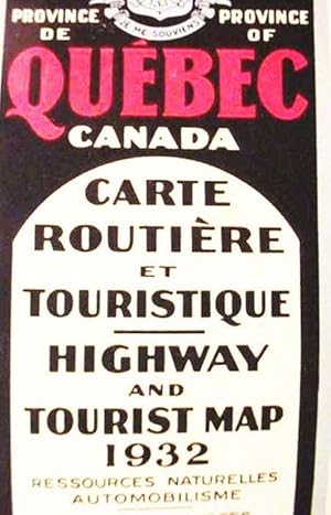
Province De / Province Of / Quebec / Canada / Carte / Routiere / Et / Touristique / Highway / And / Tourist Map / 1932 /./ Natural Resources / Motoring
Editore: Minister Of Roads; Quebec, Canada; pp.; Wraps; VG; nc/1932, 1932
Da: Watermark West Rare Books, Wichita, KS, U.S.A.
Valutazione del venditore 4 su 5 stelle
Mappa
No Binding. Condizione: Very Good. ____Single sheet, 18.5 x 45", printed on both sides in full color and folded to 28 panels. _____ The front has two title panels and two of tourist information in French and English._____ It is dominated by a 37 x 16" map of the province._____ There are also inset maps of the districts of Quebec and Montreal._____ . _____ The rear has 12 panels of bilingual tourist text._____There are 12 strip maps of routes between destinations._____ There are also 16 small maps of downtowns. _____ Not in WorldCat and this 1932 issue is not in the Canadian National Catalog (11/13). _____.
-
Canada and New Brunswick - an Antique Hand Coloured Map.
Lingua: Inglese
Editore: Tallis, London, 1860
Da: K Books Ltd ABA ILAB, York, YORKS, Regno Unito
Membro dell'associazione: ABA ILAB PBFA
Valutazione del venditore 5 su 5 stelle
EUR 65,38
Spedizione EUR 22,51
Spedito da Regno Unito a U.S.A.Quantit�: 1 disponibili
Aggiungi al carrelloNo Binding. Condizione: Very Good. An original antique hand coloured map - printed by Tallis about 1860 - mounted and ready to frame - rather attractive and somewhat uncommon .With vignettes of Quebec, Indians etc - a most attractive map.
-
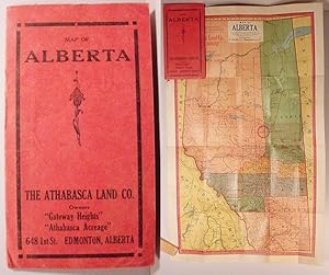
Map Of / Alberta / The Athabasca Land Co. / Owners / "Gateway Heights" / "Athabasa Acreage"
Editore: Kenyon Co.; Des Moines, Ia; 1912/nd; Very Good in Soft Covers, 1912
Da: Watermark West Rare Books, Wichita, KS, U.S.A.
Valutazione del venditore 4 su 5 stelle
Mappa
Soft cover. Condizione: Very Good. _____Small pocket map in 5.5 x 3", printed paper covers._____ The full color map is 19 x 11.75", folded to 20 panels._____ It shows section lines, mainly in the southeast part of the province._____ Athabasca Landing is bullseyed as it is the location of the sponsoring firm's land holdings described on the inside front cover._____ Railroads and Indian Reservations are indicated._____ The rear of the map is the town locator index._____ There are a couple of 2" splits to internal folds._____ Not in WorldCat (01/16)._____.
-
North America, Lower Canada and New Brunswick, with Part of New York , vermont and Maine - an Antique Map
Lingua: Inglese
Da: K Books Ltd ABA ILAB, York, YORKS, Regno Unito
Membro dell'associazione: ABA ILAB PBFA
Valutazione del venditore 5 su 5 stelle
EUR 41,61
Spedizione EUR 22,51
Spedito da Regno Unito a U.S.A.Quantit�: 1 disponibili
Aggiungi al carrelloNo Binding. Condizione: Very Good. Engraved By Walker (illustratore). A fine antique map in very good condition - printed in circa 1844. Mounted (matted) and ready to frame. Engraved size approx 16 x 13 Ins, 41 x 33 Cms. Mounted size approx 19 x 16 in, 49 x 41cm. Coloured in outline, hand colouring contemporary. A fine engraved map of North America, Lower Canada and New Brunswick, with Part of New York , vermont and Maine.
-
North America and Canada - an Antique Map
Lingua: Inglese
Da: K Books Ltd ABA ILAB, York, YORKS, Regno Unito
Membro dell'associazione: ABA ILAB PBFA
Valutazione del venditore 5 su 5 stelle
EUR 41,61
Spedizione EUR 22,51
Spedito da Regno Unito a U.S.A.Quantit�: 1 disponibili
Aggiungi al carrelloNo Binding. Condizione: Very Good. Engraved By Walker (illustratore). A fine antique map in very good condition - printed in circa 1844. Mounted (matted) and ready to frame. Engraved size approx 16 x 13 Ins, 41 x 33 Cms. Mounted size approx 19 x 16 in, 49 x 41cm. Coloured in outline, hand colouring contemporary. A fine engraved map of North America and Canada.
-
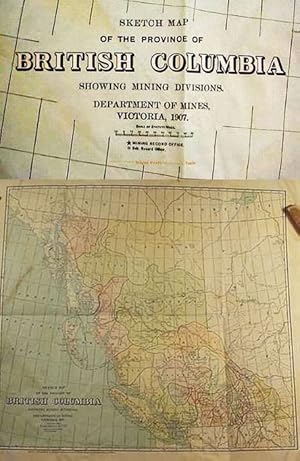
Sketch Map / Of The Province Of / British Columbia / Showing Mining Divisions
Editore: Department Of Mines; Victoria B.C.; pp.; ; VG-; nc/1907, 1907
Da: Watermark West Rare Books, Wichita, KS, U.S.A.
Valutazione del venditore 5 su 5 stelle
Mappa
No Binding. Condizione: Good. _____Multi-color map, 20.5 x 22.25, on light-weight paper, folded to eighths._____ . _____ Shows district boundaries, towns, rivers (with dangerous sections noted), existing and proposed railroads, and wagon roads and trails. _____ Wrinkled over-all, with corner creasing and light soiling. _____.
-
British Columbia Advertisers official automobile road map of British Columbia and Alberta, with Northern Washington, Idaho & Montana. . . .
Editore: The Fred Cox Service, Ltd., label pasted over British Columbia Advertisers, Engineering & Architectural Design Dept., [ca. 1928]., Victoria, BC:, 1928
Da: Zephyr Used & Rare Books, Vancouver, WA, U.S.A.
Membro dell'associazione: ABAA CBA ESA ILAB
Valutazione del venditore 5 su 5 stelle
Prima edizione
One oblong atlas folio map. 42 x 28.5 in. when unfolded, 5 x 10.75 in. when folded. Printed in red, white & blue, w/ roads indicated in red. Preserved in original advertising map folder, tan covers, printed in red on front & back, advertising Gutta Percha Tires and the Auto Service Club of British Columbia (minor chipping to corners of covers, toning; map w/ couple very small closed tears at creases, very slight wear), still VG- copy, w/ ink annotations on back cover of folder. First edition of this scarce automobile travel map through the Pacific Northwest and British Columbia during the Roaring 20s, with detailed mileage indicated between destinations. There is inset detail map of the Peace River District and Peace River Block West to Hudson Hope showing roads and trails. Worldcat locates 1 copy (Univ. of Wash).
-
![Immagine del venditore per List of map sources. Liste des cartes utilise?es. 1972 [LeatherBound] venduto da S N Books World](https://pictures.abebooks.com/inventory/md/md32213665746.jpg)
List of map sources. Liste des cartes utilise?es. 1972 [LeatherBound]
Lingua: Inglese
Data di pubblicazione: 2025
EUR 26,61
Spedizione gratuita
Spedito da India a U.S.A.Quantit�: 18 disponibili
Aggiungi al carrelloLeatheBound. Condizione: New. BOOKS ARE EXEMPT FROM IMPORT DUTIES AND TARIFFS; NO EXTRA CHARGES APPLY. Leatherbound edition. Condition: New. Leather Binding on Spine and Corners with Golden leaf printing on spine. Bound in genuine leather with Satin ribbon page markers and Spine with raised gilt bands. Pages: 100. A perfect gift for your loved ones. Reprinted from 1972 edition. NO changes have been made to the original text. This is NOT a retyped or an ocr'd reprint. Illustrations, Index, if any, are included in black and white. Each page is checked manually before printing. As this print on demand book is reprinted from a very old book, there could be some missing or flawed pages, but we always try to make the book as complete as possible. Fold-outs, if any, are not part of the book. If the original book was published in multiple volumes then this reprint is of only one volume, not the whole set. IF YOU WISH TO ORDER PARTICULAR VOLUME OR ALL THE VOLUMES YOU CAN CONTACT US. Resized as per current standards. Sewing binding for longer life, where the book block is actually sewn (smythe sewn/section sewn) with thread before binding which results in a more durable type of binding. Language: English Pages: 100.