Importo totale (1 articolo articoli):
Destinazione ordine:

map fox hunting (2 risultati)
Vai alla pagina principale dei risultati di ricerca
Filtri di ricerca
Tipo di articolo
- Tutti i tipi di prodotto
- Libri (Nessun altro risultato corrispondente a questo perfezionamento)
- Riviste e Giornali (Nessun altro risultato corrispondente a questo perfezionamento)
- Fumetti (Nessun altro risultato corrispondente a questo perfezionamento)
- Spartiti (Nessun altro risultato corrispondente a questo perfezionamento)
- Arte, Stampe e Poster (Nessun altro risultato corrispondente a questo perfezionamento)
- Fotografie (Nessun altro risultato corrispondente a questo perfezionamento)
- Mappe (2)
- Manoscritti e Collezionismo cartaceo (Nessun altro risultato corrispondente a questo perfezionamento)
Condizioni Maggiori informazioni
- Nuovo (Nessun altro risultato corrispondente a questo perfezionamento)
- Come nuovo, Ottimo o Quasi ottimo (Nessun altro risultato corrispondente a questo perfezionamento)
- Molto buono o Buono (2)
- Discreto o Mediocre (Nessun altro risultato corrispondente a questo perfezionamento)
- Come descritto (Nessun altro risultato corrispondente a questo perfezionamento)
Legatura
Ulteriori caratteristiche
- Prima ed. (1)
- Copia autograf. (Nessun altro risultato corrispondente a questo perfezionamento)
- Sovracoperta (Nessun altro risultato corrispondente a questo perfezionamento)
- Con foto (2)
- Non Print on Demand (2)
Lingua (1)
Prezzo
- Qualsiasi prezzo
- Inferiore a EUR 20 (Nessun altro risultato corrispondente a questo perfezionamento)
- EUR 20 a EUR 45 (Nessun altro risultato corrispondente a questo perfezionamento)
- Superiore a EUR 45
Spedizione gratuita
- Spedizione gratuita in U.S.A. (Nessun altro risultato corrispondente a questo perfezionamento)
Paese del venditore
Valutazione venditore
-
Fox Hunting Map of Wiltshire [cover title]
Editore: Longmans & Co, London, 1850
Da: Michael Treloar Booksellers ANZAAB/ILAB, Adelaide, SA, Australia
Membro dell'associazione: ANZAAB ILAB
Valutazione del venditore 5 su 5 stelle

Mappa Prima edizione
EUR 139,60
Spedizione EUR 20,62
Spedito da Australia a U.S.A.Quantità: 1 disponibili
Aggiungi al carrelloHardcover. Condizione: Very Good. First Edition. London, Longmans & Co., [circa 1850s]. A lithographed map (approximately 400 × 340 mm), extensively hand-coloured in outline, dissected into 15 panels and mounted on linen (as issued), folded and mounted on the inside rear surface of cloth boards (external dimensions 123 × 100 mm). Red pebble-grain cloth stamped in blind and lettered in gilt; marbled paper on the exposed pastedown and cloth panel of the folded map; ownership stamp on the pastedown and one cloth panel; in excellent condition. The first issue of this map appeared in 'Hobson's Fox-Hunting Atlas', which comprised county maps from the 'British Atlas' of J. & C. Walker (first published in 1837). This version is a lithographic transfer, taken from the original steel plate engraved by J. & C. Walker, overprinted with 'Places of the meeting of foxhounds' and boundaries of the various hunts. These include the Vale of White Horse, the Craven, the Tiedworth, and the Duke of Beaufort. 'J. & C. Walker' appears under the title, and 'No. 38' is printed in two margins.
-
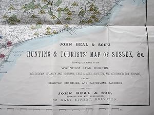
John Beal & Son's Hunting & Tourist Map of Sussex, &c, showing the Meets of the Warnham Stag Hounds, Southdown, Crawley and Horsham, East Sussex, Burstow, and Goodwood Fox Hounds, and the Brighton, Brookside, and Eastbourne Harriers.
Editore: John Beal & Son, Brighton, 1875
Da: Angelika C. J. Friebe Ltd. - MapWoman, Dorking, Regno Unito
Membro dell'associazione: ABA ILAB
Valutazione del venditore 4 su 5 stelle

Mappa
EUR 352,41
Spedizione EUR 23,20
Spedito da Regno Unito a U.S.A.Quantità: 1 disponibili
Aggiungi al carrelloSoft cover. Condizione: Very Good. colourprinted folding map; overall 48 x 89 cm, folds as issued; on linen; some damage in crossfolds; occassionally paper lifted off the folds; small faint stain in lower part of the map; o verso, cloth discolured; o/w vg cond. green cloth cover; overall 19,5 x 11 cm; some wear and tear; o/w vg cond. 10pp booklet attached to cover; some discolouration; o/w vg cond.- A very attractive map of Sussex with parts of Surrey, Hampshire and Kent, outlining the various meets. The booklet contains detailed references to the meets with information about their meets.
![Immagine del venditore per Fox Hunting Map of Wiltshire [cover title] venduto da Michael Treloar Booksellers ANZAAB/ILAB](https://pictures.abebooks.com/inventory/md/md30474287198.jpg)