
Importo totale (1 articolo articoli):
Destinazione ordine:

mathaus merian (8 risultati)
Vai alla pagina principale dei risultati di ricerca
Filtri di ricerca
Tipo di articolo
- Tutti i tipi di prodotto
- Libri (5)
- Riviste e Giornali (Nessun altro risultato corrispondente a questo perfezionamento)
- Fumetti (Nessun altro risultato corrispondente a questo perfezionamento)
- Spartiti (Nessun altro risultato corrispondente a questo perfezionamento)
- Arte, Stampe e Poster (1)
- Fotografie (Nessun altro risultato corrispondente a questo perfezionamento)
- Mappe (2)
- Manoscritti e Collezionismo cartaceo (Nessun altro risultato corrispondente a questo perfezionamento)
Condizioni Maggiori informazioni
- Nuovo (1)
- Come nuovo, Ottimo o Quasi ottimo (Nessun altro risultato corrispondente a questo perfezionamento)
- Molto buono o Buono (2)
- Discreto o Mediocre (Nessun altro risultato corrispondente a questo perfezionamento)
- Come descritto (5)
Legatura
- Tutte
- Rilegato (2)
- Brossura (Nessun altro risultato corrispondente a questo perfezionamento)
Ulteriori caratteristiche
- Prima ed. (Nessun altro risultato corrispondente a questo perfezionamento)
- Copia autograf. (Nessun altro risultato corrispondente a questo perfezionamento)
- Sovracoperta (Nessun altro risultato corrispondente a questo perfezionamento)
- Con foto (5)
- Non Print on Demand (8)
Lingua (2)
Spedizione gratuita
- Spedizione gratuita in U.S.A. (Nessun altro risultato corrispondente a questo perfezionamento)
Paese del venditore
Valutazione venditore
-

Merian Topographia Germaniae Braunschweig L�neburg
Editore: Offizin, 2005
Da: Antiquariat Volkmar Dienstbier, Heuchling, BY, Germania
Valutazione del venditore 4 su 5 stelle

EUR 3,95
Spedizione EUR 19,00
Spedito da Germania a U.S.A.Quantit�: 1 disponibili
Aggiungi al carrelloHardcover. Condizione: Neu. Reprint.
-

Bodensee-Ansichten und Beschreibungen. Aus der Topographie ausgew�hlt und in die Sprache unserer Zeit �bertragen v. Helmut Bender.
Editore: Konstanz, Stadler 1981., 1981
Da: Antiquariat Markus Wolter, Emmendingen bei Freiburg, Germania
Valutazione del venditore 5 su 5 stelle

EUR 7,00
Spedizione EUR 18,99
Spedito da Germania a U.S.A.Quantit�: 1 disponibili
Aggiungi al carrello29 x 22,5 cm. 77 S. mit Ill. OPp. Sehr gutes Exemplar.
-
Topographia und Eingentliche Beschreibung Der vornembsten State Schl�sser auch anderer Pl�tze und �rter in denen Herzogth�mer Braunschweig und Luneb�rg und denen dazu geh�renden Grafschaften Herrschaften und Landen. Francfurt 1654. Neu hrsg. von Lukas Heinrich W�thrich.
Editore: B�renreiter, Kassel-Basel, 1961
Da: Antiquariat Leseband, Freiburg, Germania
Valutazione del venditore 4 su 5 stelle
EUR 35,00
Spedizione EUR 70,00
Spedito da Germania a U.S.A.Quantit�: 1 disponibili
Aggiungi al carrelloHardcover. Condizione: Gut. Nachdruck der Originalausgabe von 1654. 3 Bl.+220 + 7 Bl. (Register)+ 14 S. mit Verzeichnis (2. Bl�tter) mit zahlreichen Falttafeln. Quarto. Or.-Pappband. Private Widmung. Insgesamt recht gut erhalten. Buch.
-
Noua Totius Germaniae descriptio. - Teutschland.
Lingua: Tedesco
Editore: Merian. Basel., 1643
Da: avelibro OHG, Dinkelscherben, Germania
Membro dell'associazione: BOEV
Valutazione del venditore 5 su 5 stelle
Arte / Stampa / Poster
EUR 90,00
Spedizione EUR 10,00
Spedito da Germania a U.S.A.Quantit�: 1 disponibili
Aggiungi al carrello27 x 35,5 cm. Condizione: Gut. Kupferstich. Merian, Math�us. Kupferstich aus " Theatrum Europ�um ". Deutschland mit seinen angrenzenden Nachbarn. deu S 3|1069AG Sprache: Deutsch Gewicht in Gramm: 444.
-
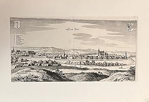
Stadt Retz.
Editore: [Frankfurt, um 1703], 1703
Da: Antiquariat Burgverlag, Wien, Austria
Membro dell'associazione: ILAB VDA VDAO
Valutazione del venditore 5 su 5 stelle
EUR 100,00
Spedizione EUR 65,00
Spedito da Austria a U.S.A.Quantit�: 1 disponibili
Aggiungi al carrelloKupferstich. 28,9 x 38, 8 cm (Blattgr.), 19,2 x 36, 8 cm (Plattengr.). Unter Passepartout. Mit mittiger Falzspur, Papierfalten unter dem Druck erkennbar. Ansicht der Stadt Reetz/Recz in der polnischen Woiwodschaft Westpommern von Matth�us Merian (1593-1650), wohl aus einer sp�teren, um 1703 erschienen Ausgabe der "Topographia Electoratus Brandeburgici". (S. 88; EA: 1652). Gewicht in Gramm: 500.
-

Burgos.
Editore: 1640, 1640
Da: Libreria Pontes, Madrid, M, Spagna
Membro dell'associazione: AILA ILAB
Valutazione del venditore 5 su 5 stelle
EUR 275,00
Spedizione EUR 14,50
Spedito da Spagna a U.S.A.Quantit�: 1 disponibili
Aggiungi al carrelloGrabado calcogr�fico.Blanco y negro. Medidas de 34x 25 cms.El grabado sugue el modelo de Braun Hogenberg del Civitates Orbis Terrarum.El grabado aparece en la obra monumental de Merian 'Topographia' compuesta por 21 volumenes.
-

1638 Campia. Campen.
Da: New World Cartographic, Chicago, IL, U.S.A.
Membro dell'associazione: ABAA ILAB
Valutazione del venditore 4 su 5 stelle
Mappa
By: Matthaus MerianDate:1638(published)FrankfurtDimensions: 8.2 x 12.7 inches (20.8 x 32.3 cm)Campen (aka Kampen) is one of the few Hansa Towns in the Netherlands. This typically organized and well-fortified small city depicted by Merian was a member of the powerful medieval Hanseatic League.The League was created by governments and seafaring merchants in order to better organize trade in northern Europe, eventually evolving into a powerful political power. It also served as a strong line of defense against piracy. The League included around 150 cities and seven countries along the North Sea and Baltic Sea area. The cities were commonly organized in the fashion depicted by Merian, with high walls built near the sea and moats or rivers as a second line of defense.Hansa Towns were prosperous, and many have retained their Middle Ages charm, including monuments and medieval housing. Kampen today is charming and quiet, with beautiful churches, cobbled streets and atmospheric panoramas, resembling other member towns such as Tallinn in Estonia, Vilnius in Lithuania, and Riga, LatviaThe Hansa Towns were prosperous places and you can see that when you visit their history-filled streets. They are rich in monuments and beautiful old houses. Kampen is very charming, friendly and quiet. As soon as you cross the cool bridge from the train station to the city, you go back in time as you walk the ancient cobbled streets of Kampen.Condition: This map is inA condition offering a lovely uncolored image with some light foxing in wide margins.Inventory #121771200 W. 35th Street #425 Chicago, IL 60609 | P: (312) 496 - 3622.
-

Amsterdam - Matth�us Merian, 1638
Da: Inter-Antiquariaat Mefferdt & De Jonge, Amsterdam, Paesi Bassi
Membro dell'associazione: ILAB NVVA
Valutazione del venditore 4 su 5 stelle
Mappa
EUR 575,00
Spedizione EUR 42,00
Spedito da Paesi Bassi a U.S.A.Quantit�: 1 disponibili
Aggiungi al carrello"Amsterdam", copper engraving made by Matth�us Merian in 1638 for the "Newe Archontologia Cosmica" by J.L. Gottfried. Coloured by a later hand. Size: 27 � 35 cm. This decorative city plan depicts Amsterdam in bird's-eye view, seen from the IJ, where numerous ships emphasize the bustling activity of the harbour. In the upper corners, the city's coat of arms and seal are shown. Soon after the completion of the Third Expansion ("Derde Uitleg") in 1625, city plans began to appear showing the outline of a subsequent enlargement. The line of fortifications was projected to extend from the Leidsegracht across the Amstel, terminating at the IJ. This gave the city a symmetrical outline, characteristic of Amsterdam's later formalso clearly visible on Merian's plan. While the Third Expansion had been completed, the next major enlargement to the east and south still largely remained to be realised. Within the new line of fortifications, the canal belt ("Grachtengordel") is not yet shown in its finished state. Large parts of the intended expansion area still consist of elongated plots and agricultural or yet-to-be expropriated land lying outside the then-existing city. Price: Euro 575,-.
