Importo totale (1 articolo articoli):
Destinazione ordine:

mercator hondius (582 risultati)
Vai alla pagina principale dei risultati di ricerca
Filtri di ricerca
Tipo di articolo
- Tutti i tipi di prodotto
- Libri (171)
- Riviste e Giornali (Nessun altro risultato corrispondente a questo perfezionamento)
- Fumetti (Nessun altro risultato corrispondente a questo perfezionamento)
- Spartiti (Nessun altro risultato corrispondente a questo perfezionamento)
- Arte, Stampe e Poster (129)
- Fotografie (1)
- Mappe (281)
- Manoscritti e Collezionismo cartaceo (Nessun altro risultato corrispondente a questo perfezionamento)
Condizioni Maggiori informazioni
Legatura
Ulteriori caratteristiche
- Prima ed. (12)
- Copia autograf. (Nessun altro risultato corrispondente a questo perfezionamento)
- Sovracoperta (3)
- Con foto (404)
- Non Print on Demand (576)
Lingua (6)
Spedizione gratuita
Paese del venditore
Valutazione venditore
-
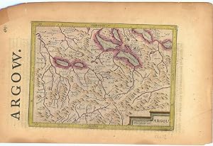
Argow (Aargau).
Editore: LondonPrinted by T.Cotes for Michael Sparkes and Samuel Cartwright ., 1635
Da: Robert Frew Ltd. ABA ILAB, London, Regno Unito
Membro dell'associazione: ABA ILAB PBFA
Valutazione del venditore 5 su 5 stelle

Mappa
EUR 29,78
Spedizione EUR 11,57
Spedito da Regno Unito a U.S.A.Quantit�: 1 disponibili
Aggiungi al carrelloOriginal engraved map of Argau / Switzerland (map dimensions 19.2 x 14 cm, overall dimensions 29.5 x 18.5 cm) with later hand-colouring. Covering the area around the Lake Lucerne, Lake Zurich and Lake Thun. With English text to verso. A bit tanned and with a few small nicks to margins, generally very good. From "Historia Mundi or Mercator's Atlas .".
-

Europe Map.
Editore: New York: Penn Prints.
Da: Wittenborn Art Books, San Francisco, CA, U.S.A.
Valutazione del venditore 5 su 5 stelle
Arte / Stampa / Poster
Condizione: Good. Facsimile of Early Mercator map of Europe. 1663. 14 x 17.5 inches.
-
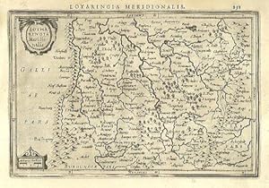
Lotharingia Meridionalis.
Editore: AmsterdamJansson., 1634
Da: Robert Frew Ltd. ABA ILAB, London, Regno Unito
Membro dell'associazione: ABA ILAB PBFA
Valutazione del venditore 5 su 5 stelle
Mappa
EUR 47,65
Spedizione EUR 11,57
Spedito da Regno Unito a U.S.A.Quantit�: 1 disponibili
Aggiungi al carrello13.4 x 19.9 cm. Uncoloured. Single page map of southern Lorraine. Latin text on verso. Light dampstain at upper left corner, otherwise in good condition.
-
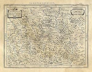
Saxoni� Superioris Lusati� Misnieque descriptio.
Editore: AmsterdamJansson., 1634
Da: Robert Frew Ltd. ABA ILAB, London, Regno Unito
Membro dell'associazione: ABA ILAB PBFA
Valutazione del venditore 5 su 5 stelle
Mappa
EUR 47,65
Spedizione EUR 11,57
Spedito da Regno Unito a U.S.A.Quantit�: 1 disponibili
Aggiungi al carrello13.6 x 18.2 cm. Uncoloured. Single page map of Saxony and the surrounding regions. Latin text on verso. Dampstain across upper and right edges of sheet, browned overall.
-
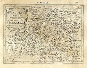
Waldeck Comitatus.
Editore: AmsterdamJansson., 1634
Da: Robert Frew Ltd. ABA ILAB, London, Regno Unito
Membro dell'associazione: ABA ILAB PBFA
Valutazione del venditore 5 su 5 stelle
Mappa
EUR 47,65
Spedizione EUR 11,57
Spedito da Regno Unito a U.S.A.Quantit�: 1 disponibili
Aggiungi al carrello14.2 x 19.3 cm. Uncoloured. Single page map of the region surrounding Waldeck, northern Hessen. Latin text on verso. Light dampstain across upper and right edges of sheet.
-
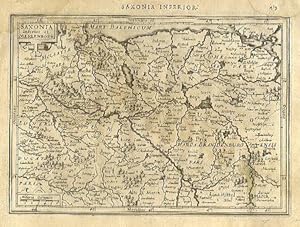
Saxonia Inferior et Meklenborg.
Editore: AmsterdamJansson., 1634
Da: Robert Frew Ltd. ABA ILAB, London, Regno Unito
Membro dell'associazione: ABA ILAB PBFA
Valutazione del venditore 5 su 5 stelle
Mappa
EUR 47,65
Spedizione EUR 11,57
Spedito da Regno Unito a U.S.A.Quantit�: 1 disponibili
Aggiungi al carrello14.2 x 20 cm. Uncoloured. Single page map showing what are now the regions of Schwerin, Rostock and Neubrandenburg. Latin text on verso. Dampstain across upper and right edges of sheet, browned overall.
-
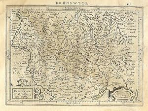
Braunswyck et Meydburg cum confinis.
Editore: AmsterdamJansson., 1634
Da: Robert Frew Ltd. ABA ILAB, London, Regno Unito
Membro dell'associazione: ABA ILAB PBFA
Valutazione del venditore 5 su 5 stelle
Mappa
EUR 47,65
Spedizione EUR 11,57
Spedito da Regno Unito a U.S.A.Quantit�: 1 disponibili
Aggiungi al carrello14.1 x 19.3 cm. Uncoloured. Single page map of the regions of Braunschweig and Magdeburg. Latin text on verso. Dampstain across upper and right edges of sheet, browned overall.
-
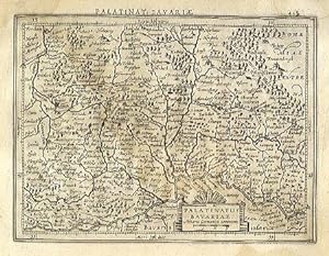
Palatinatus Bavariae.
Editore: AmsterdamJansson., 1634
Da: Robert Frew Ltd. ABA ILAB, London, Regno Unito
Membro dell'associazione: ABA ILAB PBFA
Valutazione del venditore 5 su 5 stelle
Mappa
EUR 47,65
Spedizione EUR 11,57
Spedito da Regno Unito a U.S.A.Quantit�: 1 disponibili
Aggiungi al carrello13.8 x 18.3 cm. Uncoloured. Single page map. Latin text on verso. Dampstain across upper and right edges of sheet, browned overall.
-
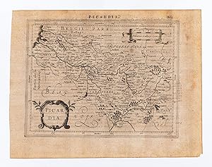
Picardia.
Editore: AmsterdamJansson., 1634
Da: Robert Frew Ltd. ABA ILAB, London, Regno Unito
Membro dell'associazione: ABA ILAB PBFA
Valutazione del venditore 5 su 5 stelle
Mappa
EUR 47,65
Spedizione EUR 11,57
Spedito da Regno Unito a U.S.A.Quantit�: 1 disponibili
Aggiungi al carrello14.5 x 18.7 cm. Uncoloured. Single page map of Picardy. Latin text on verso. Impression weaker at upper right corner. Some light soiling at margins, otherwise in good condition.
-
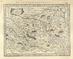
Le Duche D' Berry.
Editore: AmsterdamJansson., 1634
Da: Robert Frew Ltd. ABA ILAB, London, Regno Unito
Membro dell'associazione: ABA ILAB PBFA
Valutazione del venditore 5 su 5 stelle
Mappa
EUR 47,65
Spedizione EUR 11,57
Spedito da Regno Unito a U.S.A.Quantit�: 1 disponibili
Aggiungi al carrello14.4 x 18.1 cm. Uncoloured. Single page map. Latin text on verso. Very good condition.
-
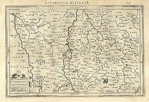
Lotharingia Septentrional.
Editore: AmsterdamJansson., 1634
Da: Robert Frew Ltd. ABA ILAB, London, Regno Unito
Membro dell'associazione: ABA ILAB PBFA
Valutazione del venditore 5 su 5 stelle
Mappa
EUR 47,65
Spedizione EUR 11,57
Spedito da Regno Unito a U.S.A.Quantit�: 1 disponibili
Aggiungi al carrello13.4 x 20.2 cm. Uncoloured. Single page map of northern Lorraine. Latin text on verso. Very good condition.
-
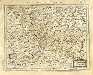
Westphali� tabula. II.
Editore: AmsterdamJansson., 1634
Da: Robert Frew Ltd. ABA ILAB, London, Regno Unito
Membro dell'associazione: ABA ILAB PBFA
Valutazione del venditore 5 su 5 stelle
Mappa
EUR 47,65
Spedizione EUR 11,57
Spedito da Regno Unito a U.S.A.Quantit�: 1 disponibili
Aggiungi al carrello13.7 x 17.7 cm. Uncoloured. Single page map of Westfalen and the Nord Rhein. Latin text on verso. Dampstaining across upper and right edges of sheet.
-

Bolonia et Guines com.
Editore: AmsterdamJansson., 1634
Da: Robert Frew Ltd. ABA ILAB, London, Regno Unito
Membro dell'associazione: ABA ILAB PBFA
Valutazione del venditore 5 su 5 stelle
Mappa
EUR 47,65
Spedizione EUR 11,57
Spedito da Regno Unito a U.S.A.Quantit�: 1 disponibili
Aggiungi al carrello14.6 x 18 cm. Uncoloured. Single page map of the region surrounding Boulogne. Latin text on verso. Small red mark to centre right of image. Some show through text, otherwise in good condition.
-
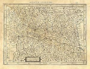
Alsatia superior cu Suntgoia & Brisgoia.
Editore: AmsterdamJansson., 1634
Da: Robert Frew Ltd. ABA ILAB, London, Regno Unito
Membro dell'associazione: ABA ILAB PBFA
Valutazione del venditore 5 su 5 stelle
Mappa
EUR 47,65
Spedizione EUR 11,57
Spedito da Regno Unito a U.S.A.Quantit�: 1 disponibili
Aggiungi al carrello14 x 19.1 cm. Uncoloured. Single page map of southern Alsace. Latin text on verso. Dampstain across upper and right edges of sheet, browned overall.
-
Palatinat. Bavariae
Editore: Amsterdam: Mercator/Hondius, 1609., 1609
Da: William Matthews/The Haunted Bookshop, Sidney, BC, Canada
Membro dell'associazione: ABAC ILAB
Valutazione del venditore 5 su 5 stelle
EUR 47,89
Spedizione EUR 15,50
Spedito da Canada a U.S.A.Quantit�: 1 disponibili
Aggiungi al carrelloA copper engraved map on laid paper, uncoloured, from the 1609 German edition of the Mercator/Hondius ATLAS MINOR. Image size is 18cm x 13.5cm, on a sheet measuring 23cm x 18cm (9 x 7 inches). Cartouche at upper right. Text on map is in Latin. Text on verso is German. Page number on verso is 442. Clean, short tear in lower margin, very good condition. A regional map of Germany, Bavaria.
-
Abruzzo et Terra di Lovoro
Editore: Amsterdam: Mercator/Hondius, 1609., 1609
Da: William Matthews/The Haunted Bookshop, Sidney, BC, Canada
Membro dell'associazione: ABAC ILAB
Valutazione del venditore 5 su 5 stelle
EUR 47,89
Spedizione EUR 15,50
Spedito da Canada a U.S.A.Quantit�: 1 disponibili
Aggiungi al carrelloA copper engraved map on laid paper, uncoloured, from the 1609 German edition of the Mercator/Hondius ATLAS MINOR. Image size is 18cm x 14.5cm, on a sheet measuring 23cm x 18cm (9 x 7 inches). Cartouche at lower right. Text on map is in Latin. Text on verso is German. Page number on verso is 536. Clean, very good condition. A regional map of Italy.
-
Romandi Ola cum D. Parmensi.
Editore: Amsterdam: Mercator/Hondius, 1609., 1609
Da: William Matthews/The Haunted Bookshop, Sidney, BC, Canada
Membro dell'associazione: ABAC ILAB
Valutazione del venditore 5 su 5 stelle
EUR 47,89
Spedizione EUR 15,50
Spedito da Canada a U.S.A.Quantit�: 1 disponibili
Aggiungi al carrelloA copper engraved map on laid paper, uncoloured, from the 1609 German edition of the Mercator/Hondius ATLAS MINOR. Image size is 18cm x 14cm, on a sheet measuring 23.5cm x 18.5cm (9 x 7 inches). Cartouche in lower right. Text on map in Latin. Text on verso is German. Page number on verso is 504. Clean, very good condition. A regional map of Italy.
-
Austria archiduc.
Editore: Amsterdam: Mercator/Hondius, 1609., 1609
Da: William Matthews/The Haunted Bookshop, Sidney, BC, Canada
Membro dell'associazione: ABAC ILAB
Valutazione del venditore 5 su 5 stelle
EUR 47,89
Spedizione EUR 15,50
Spedito da Canada a U.S.A.Quantit�: 1 disponibili
Aggiungi al carrelloA copper engraved map on laid paper, uncoloured, from the 1609 German edition of the Mercator/Hondius ATLAS MINOR. Image size is 19cm x 13cm, on a sheet measuring 23cm x 18cm (9 x 7 inches). Cartouche at lower left. Text on map is in Latin. Text on verso is German. Page number on verso is 464. Clean, very good condition. A map of �sterreich/Austria.
-
Congi Regnu.
Editore: Amsterdam: Mercator/Hondius, [c.1610]., 1610
Da: William Matthews/The Haunted Bookshop, Sidney, BC, Canada
Membro dell'associazione: ABAC ILAB
Valutazione del venditore 5 su 5 stelle
EUR 47,89
Spedizione EUR 15,50
Spedito da Canada a U.S.A.Quantit�: 1 disponibili
Aggiungi al carrelloA copper engraved map on laid paper, uncoloured, likely from a Latin edition of the Mercator/Hondius ATLAS MINOR. Image size is 17cm x 14cm, on a sheet measuring 23cm x 18cm (9 x 7 inches). Cartouche at lower left. Verso blank. Old stain to upper margin, lower right margin and bottom right margin are partly worn away, some small perforations; very good otherwise, image undamaaged. Notes in pen on upper margin: "No. 4" , etc. A map of the Congo, coast of Africa.
-
Westphaliae tabula. II.
Editore: Amsterdam: Mercator/Hondius, 1609., 1609
Da: William Matthews/The Haunted Bookshop, Sidney, BC, Canada
Membro dell'associazione: ABAC ILAB
Valutazione del venditore 5 su 5 stelle
EUR 47,89
Spedizione EUR 15,50
Spedito da Canada a U.S.A.Quantit�: 1 disponibili
Aggiungi al carrelloA copper engraved map on laid paper, uncoloured, from the 1609 German edition of the Mercator/Hondius ATLAS MINOR. Image size is 18cm x 13.5cm, on a sheet measuring 23cm x 18cm (9 x 7 inches). Cartouche at lower right. Text on map is in Latin. Text on verso is German. Page number on verso is 384. Clean, very good condition. A regional map of Germany.
-
Poictou
Editore: Amsterdam: Mercator/Hondius, 1609., 1609
Da: William Matthews/The Haunted Bookshop, Sidney, BC, Canada
Membro dell'associazione: ABAC ILAB
Valutazione del venditore 5 su 5 stelle
EUR 47,89
Spedizione EUR 15,50
Spedito da Canada a U.S.A.Quantit�: 1 disponibili
Aggiungi al carrelloA copper engraved map on laid paper, uncoloured, from the 1609 German edition of the Mercator/Hondius ATLAS MINOR. Image size is 19.5cm x 13.5cm, on a sheet measuring 23.5cm x 18.5cm (9 x 7 inches). Cartouche at upper right. Text on map is in Latin. Text on verso is German. Page number on verso is 258. Clean, very good condition. A regional map of France.
-
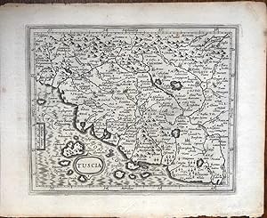
Tuscia
Editore: Amsterdam: Mercator/Hondius, 1609., 1609
Da: William Matthews/The Haunted Bookshop, Sidney, BC, Canada
Membro dell'associazione: ABAC ILAB
Valutazione del venditore 5 su 5 stelle
EUR 47,89
Spedizione EUR 15,50
Spedito da Canada a U.S.A.Quantit�: 1 disponibili
Aggiungi al carrelloA copper engraved map on laid paper, uncoloured, from the 1609 German edition of the Mercator/Hondius ATLAS MINOR. Image size is 18cm x 14.5cm, on a sheet measuring 23.5cm x 18.5cm (9 x 7 inches). Small oval title cartouche at lower left. Text on map in Latin. Text on verso is German. Page number on verso is 524. Clean, very good condition. A regional map of Italy, Tuscany and nearby.
-
Brabantia.
Editore: Amsterdam: Mercator/Hondius, 1609., 1609
Da: William Matthews/The Haunted Bookshop, Sidney, BC, Canada
Membro dell'associazione: ABAC ILAB
Valutazione del venditore 5 su 5 stelle
EUR 47,89
Spedizione EUR 15,50
Spedito da Canada a U.S.A.Quantit�: 1 disponibili
Aggiungi al carrelloA copper engraved map on laid paper, uncoloured, from the 1609 German edition of the Mercator/Hondius ATLAS MINOR. Image size is 19.5cm x 15cm, on a sheet measuring 23.5cm x 18.5cm (9 x 7 inches). Cartouche at lower left. Text on map in Latin. Text on verso is German. Page number on verso is 320. Clean, very good condition. A regional map of Holland, Southern Netherlands.
-
Lotharingia.
Editore: Amsterdam: Mercator/Hondius, 1609., 1609
Da: William Matthews/The Haunted Bookshop, Sidney, BC, Canada
Membro dell'associazione: ABAC ILAB
Valutazione del venditore 5 su 5 stelle
EUR 47,89
Spedizione EUR 15,50
Spedito da Canada a U.S.A.Quantit�: 1 disponibili
Aggiungi al carrelloA copper engraved map on laid paper, uncoloured, from the 1609 German edition of the Mercator/Hondius ATLAS MINOR. Image size is 20cm x 13.5cm, on a sheet measuring 23.5cm x 18.5cm. Cartouche in lower left. Text on map in Latin. Text on verso is German, heading "Von dem Theyl gegen Mittag .". Page number on verso is 262. Crease & stain to lower left margin, very good condition. A regional map of Lorraine, Luxembourg and Northern France.
-
Burgundiae Duca.
Editore: Amsterdam: Mercator/Hondius, 1609., 1609
Da: William Matthews/The Haunted Bookshop, Sidney, BC, Canada
Membro dell'associazione: ABAC ILAB
Valutazione del venditore 5 su 5 stelle
EUR 47,89
Spedizione EUR 15,50
Spedito da Canada a U.S.A.Quantit�: 1 disponibili
Aggiungi al carrelloA copper engraved map on laid paper, uncoloured, from the 1609 German edition of the Mercator/Hondius ATLAS MINOR. Image size is 18.5cm x 14.5cm, on a sheet measuring 23cm x 18cm (9 x 7 inches). Cartouche at lower left. Text on map is in Latin. Text on verso is German. Page number on verso is 270. Old stain to upper right margins, very good condition. A regional map of France, Burgundy, Dijon (Digion) is shown centre-right.
-
Wirtenberg.
Editore: Amsterdam: Mercator/Hondius, 1609., 1609
Da: William Matthews/The Haunted Bookshop, Sidney, BC, Canada
Membro dell'associazione: ABAC ILAB
Valutazione del venditore 5 su 5 stelle
EUR 47,89
Spedizione EUR 15,50
Spedito da Canada a U.S.A.Quantit�: 1 disponibili
Aggiungi al carrelloA copper engraved map on laid paper, uncoloured, from the 1609 German edition of the Mercator/Hondius ATLAS MINOR. Image size is 19cm x 14.5cm, on a sheet measuring 23cm x 18cm (9 x 7 inches). Cartouche at upper right. Text on map is in Latin. Text on verso is German. Page number on verso is 408. Clean, very good condition. A regional map of Germany.
-
Lotharingia Meridiona.
Editore: Amsterdam: Mercator/Hondius, 1609., 1609
Da: William Matthews/The Haunted Bookshop, Sidney, BC, Canada
Membro dell'associazione: ABAC ILAB
Valutazione del venditore 5 su 5 stelle
EUR 47,89
Spedizione EUR 15,50
Spedito da Canada a U.S.A.Quantit�: 1 disponibili
Aggiungi al carrelloA copper engraved map on laid paper, uncoloured, from the 1609 German edition of the Mercator/Hondius ATLAS MINOR. Image size is 18.5cm x 14cm, on a sheet measuring 23cm x 18cm (9 x 7 inches). Cartouche at lower left. Text on map is in Latin. Text on verso is German. Page number on verso is 266. Old stain to upper right corner, very good condition. A regional map of Lorraine, Luxembourg and Northern France.
-
Trier et Lutzeborg.
Editore: Amsterdam: Mercator/Hondius, 1609., 1609
Da: William Matthews/The Haunted Bookshop, Sidney, BC, Canada
Membro dell'associazione: ABAC ILAB
Valutazione del venditore 5 su 5 stelle
EUR 47,89
Spedizione EUR 15,50
Spedito da Canada a U.S.A.Quantit�: 1 disponibili
Aggiungi al carrelloA copper engraved map on laid paper, uncoloured, from the 1609 German edition of the Mercator/Hondius ATLAS MINOR. Image size is 18.5cm x 14cm, on a sheet measuring 23cm x 18cm (9 x 7 inches). Cartouche at lower left. Text on map is in Latin. Text on verso is German. Page number on verso is 344. Clean, very good condition. A regional map of Luxembourg.
-
Aniou.
Editore: Amsterdam: Mercator/Hondius, 1609., 1609
Da: William Matthews/The Haunted Bookshop, Sidney, BC, Canada
Membro dell'associazione: ABAC ILAB
Valutazione del venditore 5 su 5 stelle
EUR 47,89
Spedizione EUR 15,50
Spedito da Canada a U.S.A.Quantit�: 1 disponibili
Aggiungi al carrelloA copper engraved map on laid paper, uncoloured, from the 1609 German edition of the Mercator/Hondius ATLAS MINOR. Image size is 18.5cm x 14.5cm, on a sheet measuring 23.5cm x 18.5cm (9 x 7 inches). Cartouches in upper right and lower left. Text on map in Latin. Text on verso is German. Page number on verso is 250. Clean, very good condition. A regional map of France.
-
Hanonia
Editore: Amsterdam: Mercator/Hondius, 1609., 1609
Da: William Matthews/The Haunted Bookshop, Sidney, BC, Canada
Membro dell'associazione: ABAC ILAB
Valutazione del venditore 5 su 5 stelle
EUR 47,89
Spedizione EUR 15,50
Spedito da Canada a U.S.A.Quantit�: 1 disponibili
Aggiungi al carrelloA copper engraved map on laid paper, uncoloured, from the 1609 German edition of the Mercator/Hondius ATLAS MINOR. Image size is 18cm x 14.5cm, on a sheet measuring 23.5cm x 18.5cm (9 x 7 inches). Cartouches in upper corners. Text on map in Latin. Text on verso is German. Page number on verso is 340. Clean, very good condition. A regional map of Germany.