
Importo totale (1 articolo articoli):
Destinazione ordine:

parrott thomas samuel (1 risultati)
Vai alla pagina principale dei risultati di ricerca
Filtri di ricerca
Tipo di articolo
- Tutti i tipi di prodotto
- Libri (Nessun altro risultato corrispondente a questo perfezionamento)
- Riviste e Giornali (Nessun altro risultato corrispondente a questo perfezionamento)
- Fumetti (Nessun altro risultato corrispondente a questo perfezionamento)
- Spartiti (Nessun altro risultato corrispondente a questo perfezionamento)
- Arte, Stampe e Poster (Nessun altro risultato corrispondente a questo perfezionamento)
- Fotografie (Nessun altro risultato corrispondente a questo perfezionamento)
- Mappe (1)
- Manoscritti e Collezionismo cartaceo (Nessun altro risultato corrispondente a questo perfezionamento)
Condizioni Maggiori informazioni
- Nuovo (Nessun altro risultato corrispondente a questo perfezionamento)
- Come nuovo, Ottimo o Quasi ottimo (Nessun altro risultato corrispondente a questo perfezionamento)
- Molto buono o Buono (1)
- Discreto o Mediocre (Nessun altro risultato corrispondente a questo perfezionamento)
- Come descritto (Nessun altro risultato corrispondente a questo perfezionamento)
Legatura
- Tutte
- Rilegato (Nessun altro risultato corrispondente a questo perfezionamento)
- Brossura (Nessun altro risultato corrispondente a questo perfezionamento)
Ulteriori caratteristiche
- Prima ed. (1)
- Copia autograf. (Nessun altro risultato corrispondente a questo perfezionamento)
- Sovracoperta (Nessun altro risultato corrispondente a questo perfezionamento)
- Con foto (1)
- Non Print on Demand (1)
Lingua (1)
Prezzo
- Qualsiasi prezzo
- Inferiore a EUR 20 (Nessun altro risultato corrispondente a questo perfezionamento)
- EUR 20 a EUR 45 (Nessun altro risultato corrispondente a questo perfezionamento)
- Superiore a EUR 45
Spedizione gratuita
- Spedizione gratuita in U.S.A. (Nessun altro risultato corrispondente a questo perfezionamento)
Paese del venditore
Valutazione venditore
-
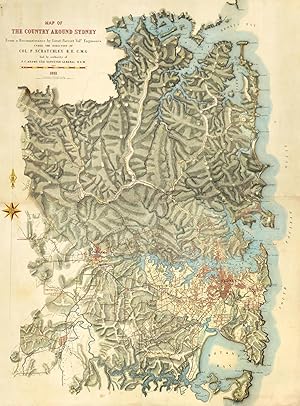
Map of the Country Around Sydney from a Reconnaissance by Lieut. Parrott Volr. Engineers under the Instructions of Col. P. Scratchley R.E. C.M.G. and by the Authority of P.F. Adams Esq. Surveyor General N.S.W.
Data di pubblicazione: 1881
Da: Antique Print & Map Room, Ultimo, NSW, Australia
Membro dell'associazione: ANZAAB ILAB
Valutazione del venditore 5 su 5 stelle

Mappa Prima edizione
EUR 6.576,87
Spedizione EUR 32,24
Spedito da Australia a U.S.A.Quantit�: 1 disponibili
Aggiungi al carrelloNo Binding. Condizione: Very Good. 1st Edition. Impressive large scale map on two sheets, covering the area from the Hawkesbury River, to Botany Bay and inland to Blacktown based on the extensive surveys undertaken by Lieutenant Thomas Parrott under the directions of Colonel Scratchley, the Commissioner of defences. Roads, settlements and isolated buildings are noted. Numerous observations and elevations are noted of the terrain, such as; 'Low Dense scrub', 'timbered and scrubby and open heath. Image Size: 1105mm x 1515mm (43.5" x 59.6"). Condition: In good condition laid onto archival linen Technique: Hand coloured lithograph.