
Importo totale (1 articolo articoli):
Destinazione ordine:

polar exploration (16 risultati)
Vai alla pagina principale dei risultati di ricerca
Filtri di ricerca
Tipo di articolo
- Tutti i tipi di prodotto
- Libri (14)
- Riviste e Giornali (1)
- Fumetti (Nessun altro risultato corrispondente a questo perfezionamento)
- Spartiti (Nessun altro risultato corrispondente a questo perfezionamento)
- Arte, Stampe e Poster (Nessun altro risultato corrispondente a questo perfezionamento)
- Fotografie (Nessun altro risultato corrispondente a questo perfezionamento)
- Mappe (1)
- Manoscritti e Collezionismo cartaceo (Nessun altro risultato corrispondente a questo perfezionamento)
Condizioni Maggiori informazioni
- Nuovo (1)
- Come nuovo, Ottimo o Quasi ottimo (Nessun altro risultato corrispondente a questo perfezionamento)
- Molto buono o Buono (6)
- Discreto o Mediocre (Nessun altro risultato corrispondente a questo perfezionamento)
- Come descritto (9)
Legatura
Ulteriori caratteristiche
- Prima ed. (6)
- Copia autograf. (Nessun altro risultato corrispondente a questo perfezionamento)
- Sovracoperta (Nessun altro risultato corrispondente a questo perfezionamento)
- Con foto (9)
- Non Print on Demand (16)
Lingua (2)
Spedizione gratuita
Paese del venditore
Valutazione venditore
-

GREATEST POLAR EXPLORATION STORIES EVER
Da: Speedyhen LLC, Hialeah, FL, U.S.A.
Valutazione del venditore 4 su 5 stelle

Condizione: NEW.
-

Nearest the North Pole. April 21, 1906 the nearest approach ever made by human beings. By Commander Robert E. Peary, U.S.N. An original article from the Harper's Monthly Magazine, 1907.
Editore: Harper's Monthly Magazine, London, 1907
Da: Cosmo Books, Shropshire., Regno Unito
Valutazione del venditore 5 su 5 stelle

Rivista / Giornale
EUR 12,98
Spedizione EUR 13,75
Spedito da Regno Unito a U.S.A.Quantit�: 1 disponibili
Aggiungi al carrelloBooklet - Unbound Pages. Condizione: Very Good. 30 page, illustrated. An authentic standalone article, extracted from a larger volume. Not a reprint or reproduction, but an original work in its own right. Supplied without title page or cover. Size: 18 x 25 cms. Category: Harper's Monthly Magazine; Cosmo Books : 29 years on ABE, 47 years taking care of customers. A bookseller you can rely on.
-
Fram.
Editore: The Committee for the Preservation of the Polar Ship Fram, Oslo, 1961
Da: Clearwater Books, London, Regno Unito
Membro dell'associazione: IOBA
Valutazione del venditore 5 su 5 stelle
Prima edizione
EUR 8,93
Spedizione EUR 22,30
Spedito da Regno Unito a U.S.A.Quantit�: 1 disponibili
Aggiungi al carrelloSoft cover. Condizione: Good. 1st Edition. The English-language issue of the first edition. Slim 8vo. 62pp stapled into somewhat dust soiled card wrappers. The staples rusted. Contemporary date inked to the head of the first leaf, and with one printed correction in the text. A good copy. An account of the polar ship Fram, penned by Henning Sinding-Larsen and based on a booklet by Knut Domass. Illustrated with twenty-two photographs and one maps. The text in English, with some summary text also presented in French and German. [A light item, UK postage will be reduced].
-
Some Account of the late Expedition to the Polar Regions, under the Command of Captain William Edward Parry. An uncommon original article from the Journal of Science and the Arts, edited by the Royal Institution of Great Britain, 1821.
Editore: Journal of Science and the Arts, London, 1821
Da: Cosmo Books, Shropshire., Regno Unito
Valutazione del venditore 5 su 5 stelle
EUR 14,17
Spedizione EUR 13,75
Spedito da Regno Unito a U.S.A.Quantit�: 1 disponibili
Aggiungi al carrelloBooklet - Unbound Pages. Condizione: Very Good. 7 pages, 1 map (some foxing). An authentic standalone article, extracted from a larger volume. Not a reprint or reproduction, but an original work in its own right. Supplied without title page or cover. Size: 13 x 21 cms. Category: Royal Institution; Cosmo Books : 29 years on ABE, 47 years taking care of customers. A bookseller you can rely on.
-

The Knights of the Frozen Sea. A Narrative of Arctic Discovery and Adventure. By the author of "Harry Lawton's Adventures." With a map, and forty-four illustrations.
Editore: Seeley, Jackson, & Halliday, 1867., 1867
Da: Charles Cox Rare Books , Bude, Regno Unito
Valutazione del venditore 5 su 5 stelle
EUR 33,33
Spedizione EUR 26,00
Spedito da Regno Unito a U.S.A.Quantit�: 1 disponibili
Aggiungi al carrelloHardcover. Condizione: Very Good. First Edition. Purple sand grain cloth, stamped in gilt and blind. Spine dull with short splits at one edge repaired, minor tear in margin of folding map, otherwise a very good copy. With chapters on early voyages, Frobisher, Buchan, McClure, Kane and McLintock, but mostly devoted to the explorations of Ross, Parry and Sir John Franklin.
-
![Immagine del venditore per [John Irving, Writer to the Signet] Printed Official Letter Signed "John Irving" to the Chief Magistrate of Dunbar [presumably also sent to other Chief Magistrates] venduto da Richard M. Ford Ltd](https://pictures.abebooks.com/inventory/md/md32424093164.jpg)
[John Irving, Writer to the Signet] Printed Official Letter Signed "John Irving" to the Chief Magistrate of Dunbar [presumably also sent to other Chief Magistrates]
Editore: Edinburgh 106 Princes Street 4 April, 1820
Da: Richard M. Ford Ltd, London, Regno Unito
Membro dell'associazione: ABA ILAB
Valutazione del venditore 5 su 5 stelle
EUR 53,56
Spedizione EUR 5,20
Spedito da Regno Unito a U.S.A.Quantit�: 1 disponibili
Aggiungi al carrelloOne page, folio, fold marks, closed tear and small loss of paper not affecting text, two small holes affecting but not obscuring words. Text: " SIR, \ You will receive enclosed [not present] the Annual Missive, with a copy of the Acts of the last Convention. By the 22nd Act, the Reports made by me in relation to the Setts of the Royal Burghs are ordered to be printed and circulated to the different Burghs. To save the expense of postage, these have not been inclosed; but a copy of them will be delivered to any person whom you desire to call here for it; or it will be sent by post if you wish this done ;subsxction and signature]". See Image. [see Note B] Notes: A. "John Irving, a lawyer who was a member of the Society of Writers to the Signet and childhood friend of Sir Walter Scott" [from Wikipedia entry for his son, polar explorer, Franklin Expedition]; B. "'Annual missive' in the context of a Scottish burgh historically refers to the yearly communication, often involving the assessment and collection of dues (missive dues) to fund the administrative expenses of the Convention of Royal Burghs." [AI].
-
The worst journey in the World: Antarctic 1910-1913. One volume edition.
Editore: Produced by the Author and published for him by Chatto & Windus,, London:, 1937
Da: Zephyr Used & Rare Books, Vancouver, WA, U.S.A.
Membro dell'associazione: ABAA CBA ESA ILAB
Valutazione del venditore 5 su 5 stelle
Prima edizione
Thick 8vo. lxiv, 585, [1] pp. With four large folding maps, numerous plates. Gray-blue publisher's cloth, black lettering front cover & spine (minor shelfwear, sunning & toning to spine, minor bumping to corners), still VG- copy, from the library of Tom Koenninger (1932-2010), former editor, managing editor, journalist for The Columbian newspaper, and board member on the Vancouver National Historic Trust. First One-Volume edition of Cherry-Garrard's account of the disastrous Robert Falcon Scott's ill-fated expedition to the South Pole, drawing on his own account and experiences, as well as the diaries of his compatriots. Cherry-Garrard and the rest of the rescue crew discovered Scott only 11 miles from their depot, frozen to death with Bowers and Wilson.
-
Andree and his balloon. . . .
Editore: Archibald Constable & Co.,, Westminster, UK:, 1898
Da: Zephyr Used & Rare Books, Vancouver, WA, U.S.A.
Membro dell'associazione: ABAA CBA ESA ILAB
Valutazione del venditore 5 su 5 stelle
Prima edizione
8vo. viii, 9-301, [3] pp., plus 15, [1] pp. publisher's illustrated catalogue. Colour chromolithograph frontisp., 44 photo plates. Blue-ribbed pictorial publisher's cloth, cover art illustration of Andree's balloon on front cover & spine (slight rubbing, very minor wear to corner tips), still VG bright largely uncut & unopened copy. First edition in English of this work examining the preparations and efforts of the Salomon August Andree's doomed Polar Expedition via balloon in 1897, traveling with Knut Fraenkel and Nils Strindberg. Andree beleived he could steer the hydrogen-filled balloon with a drag line, but this proved ineffective, and his Polar balloon, the Ornen (Eagle) leaked far more hydrogen than expected, and as of the end of this contemporary crashed and disappeared. In 1930, the expedition's last camp was discovered with documents and photos recording how they'd crashed on a drifting ice pack, poor Arctic gear, and died on Kvitoya in Svalbard.
-
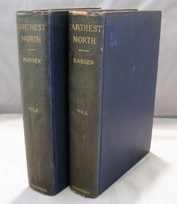
Farthest North. Being the Record of a Voyage of Exploration of the Ship "Fram" 1893-96 and of a Fifteen Months' Sleigh Journey.
Editore: Harper & Brothers, 1897
Da: Gregor Rare Books, Langley, WA, U.S.A.
Valutazione del venditore 5 su 5 stelle
Prima edizione
Hardcover. Condizione: Very Good. 1st Edition. Both volumes are Very Good plus copies in black cloth bindings with a bit of chipping to the top edge of the spine of volume one. Contains "About 120 Full-page and Numerous Text Illustrations, 16 Colored Plates in Facsimile from Dr. Nansen's Own Sketches, Etched Portrait and Photogravures. [No statement calling for maps on the title page.] There are no maps or pockets for maps in either volume and no evidence of pocket removal.
-
Centenary Celebration: The Wilkes Exploring Expedition of the United States Navy, 1838-1842, and Symposium on American Polar Exploration.
Editore: American Philosophical Society, Philadelphia, 1940
Da: Nat DesMarais Rare Books, ABAA, Portland, OR, U.S.A.
Membro dell'associazione: ABAA CBA ILAB
Valutazione del venditore 4 su 5 stelle
First edition of this gathering of essays celebrating Wilkes voyage. Octavo. [2], 519-950, v, [1], [6, publisher's catalog] pp. Publisher's printed sage wrappers. Lower corners a bit bent, some wear along front joint but a tight, clean and presentable copy.
-

Autotyped note signed "A. W. Greely," with 4 manuscript typographical error corrections
Editore: 3131 O Street NW, Washington, 1930
Da: The Old Mill Bookshop, HACKETTSTOWN, NJ, U.S.A.
Valutazione del venditore 3 su 5 stelle

1 page. 1 vols. 8vo. 1 page. 1 vols. 8vo. Saying that he does not have a photograph available at that time due to similar requests but that Halpern might check the local library and look at his book "Reminiscences." The eminent arctic explorer and American Army Officer. He commanded the American expedition in 1881 to establish circumpolar stations, discovered new land north of Greenland and reached the most northerly point to that time. In addition to his polar exploration he served in the Civil War, set up military telegraph lines in Montana, the Dakotas and Texas in the late 1870's and set up telegraph lines in China, Alaska, Cuba and the Philippine Islands. He was also in charge of the relief operations in the San Francisco area after the 1906 earthquake disaster. Greely was also the author of several volumes on the polar regions and also telegraphs. From the collection of Seymour Halpern. Seymour Halpern was a Representative from New York. From 1931 to 1933 he was a reporter and feature writer for the Long Island Daily Press and the Chicago Herald Examiner. Addressed to Seymour Halfsen, a misreading of signature of Seymour Halpern. Letter folded else very good.
-
FINDING THE NORTH POLE. DR. COOK'S OWN STORY OF HIS DISCOVERY, APRIL 21, 1908. THE STORY OF COMMANDER PEARY'S DISCOVERY, APRIL 6, 1909. TOGETHER WITH THE MARVELOUS RECORD OF FORMER ARCTIC EXPEDITIONS.
Editore: [N.p.: W.E. Scull, 1909]., 1909
Da: William Reese Company, New York, NY, U.S.A.
Membro dell'associazione: ABAA ESA ILAB SNEAB
Valutazione del venditore 5 su 5 stelle
A salesman's dummy for this polar work on the dispute between Peary and Cook over who discovered the North Pole. The sample indicates that the complete work contains over 100 illustrations, most of which are "authoritative photographs," and further states, "You have the assurance that 'FINDING THE NORTH POLE' is an authoritative work, by its Distinguished Authorship." Blanks for subscribers are included at the back, though several have been cut out (presumably those with names on them). An interesting artifact from the polar craze of the early 20th century. Unpaginated. Original green pictorial publisher's cloth, stamped in red, gold, and blue. Spine ends worn, corners bumped, lightly soiled. Good.
-
A complete series of 25 cards, very slight wear but in excellent, bright condition
Editore: John Player & Sons, Nottingham, no date
Da: Bertram Rota Ltd, Kintbury, Regno Unito
Valutazione del venditore 5 su 5 stelle
EUR 149,98
Spedizione EUR 40,45
Spedito da Regno Unito a U.S.A.Quantit�: 1 disponibili
Aggiungi al carrelloThe first of two series issued by Player, this featuring both Arctic and Antarctic expeditionsWe regret that VAT must be charged on orders from clients within the EU for this item.
-
Die oesterreichisch-ungarische Nordpol-Expedition in den Jahren 1872-1874, nebst einer Skizze der zweiten deutschen Nordpol-Expedition 1869-1870 und der Polar-Expedition von 1871
Editore: Alfred H�lder, Wien [Vienna], 1876
Da: Capitol Hill Books, ABAA, Washington, DC, U.S.A.
Membro dell'associazione: ABAA ILAB
Valutazione del venditore 5 su 5 stelle
Prima edizione
Condizione: Very Good+. Wein [Vienna]: Alfred H�lder, 1876. First Edition. Large octavo (24 cm); cvi; 696pp; woodblock illus. throughout and 57 plates including frontis; 3 folding maps. Boards in brown cloth with gilt and black pictorial stamping. Edges marbled. Board extremities rubbed and slightly worn with shelfwear and clean break to spine tail above headband. Reinforced hinges to endsheets, possible repair. Brief pencil at title page, helpfully translating a few of the German letters for an English reader. Two of the three maps have small tears to gutter edge but otherwise intact. Light foxing throughout. A Very Good or better copy. An account of the successful Austro-Hungarian North Pole expedition lead by Julius Payer and Karl Weyprecht, detailing their discovery of Franz Josef Land in the arctic ocean after they lost their ship to the ice and had to sled back to Novaya Zemlya in Russia just before supplies ran out. The expedition made multiple contributions to polar science, including magnetism and detailed sightings of the Aurora Borealis.
-
The Polar Book.
Editore: London: E. Allom & Co. Ltd., [1930], 1930
Da: Peter Harrington. ABA/ ILAB., London, Regno Unito
Membro dell'associazione: ABA ILAB PBFA
Valutazione del venditore 5 su 5 stelle
Prima edizione
EUR 714,17
Spedizione EUR 25,42
Spedito da Regno Unito a U.S.A.Quantit�: 1 disponibili
Aggiungi al carrelloFirst edition of this survey of polar exploration and science, issued in conjunction with the British Polar Exhibition of 1930, an event organised to support the recently established Scott Polar Research Institute. Edited by the Antarctic explorer Louis Bernacchi, the volume gathers contributions from prominent polar figures including Frank Debenham, first director of the Scott Polar Research Institute, and James Mann Wordie, polar explorer and geologist, covering subjects such as the history of polar discovery, geophysics, whaling, polar biology, and the provisioning of sledge expeditions. Octavo. With 2 colours maps on one folding sheet. Original pictorial wrappers with polar animals, spine lettered in black, front wrapper lettered in black and yellow. Bookplate of Peter L. Keage, Antarctic researcher to inner front cover. General marking, diagonal crease on front cover. A near-fine copy.
-

Expedition Francaise au Pole Nord sou le Commandement de Mr. Gustave Lambert. Regions Polaires Boreales.
Data di pubblicazione: 1867
Da: Geographicus Rare Antique Maps, Brooklyn, NY, U.S.A.
Membro dell'associazione: ABAA ESA ILAB
Valutazione del venditore 3 su 5 stelle
Mappa
Good. Light wear along original fold lines. Light toning. Verso repairs to fold separations. Size 13 x 11.75 Inches. This is an 1867 Victor-Auguste Malte-Brun and Georges Erhard Schi�ble map of the North Pole highlighting three proposed polar expeditions. The map captures the peak of the global competition to reach the North Pole. Reaching the Pole was considered a matter of national pride, with both government-funded and private expeditions making the attempt. This map captures rival proposals by French, English, and German explorers. A Closer Look With the North Pole at the center, coverage embraces the northern parts of the Earth as far south as the Black Sea and the Great Lakes. Red lines trace proposed English, French, and German expeditions to the North Pole. Four smaller maps (one in each corner) illustrate the proposed route of the French expedition, the South Polar regions, the variation in the Magnetic North Pole, and the average insolation curve for June 21, 1867, respectively. Three Proposed Expeditions Three red lines trace proposed expeditions to reach the North Pole. These were proposed by Sherard Osborn (British Royal Navy officer and Arctic explorer), Augustus Petermann (German cartographer and publisher), and Gustave Lambert (French hydrographer and Arctic explorer). Each was either an experienced Arctic (Osborn and Lambert) traveler or considered a geographical expert (Petermann). Petermann : Petermann's (1822 - 1878) efforts to push Germany into the race to explore the North Pole gave rise to the 1868 First German North Polar Expedition, which explored the northeastern coast of Spitsbergen (as suggested by Petermann) and prepared the way for the 1869 Second German North Polar Expedition Osborn : Osborn's (1822 - 1875) proposal led to the 1875-76 British Arctic Expedition. Osborn himself was set to be a member of the expedition committee but tragically died in London only a few days after the expedition set sail. The expedition, nonetheless, pressed on. They successfully pushed farther north than any previous voyage, reaching a record latitude of 83�20'26'' N, but were ultimately thwarted by extreme cold, scurvy, and difficult ice conditions. Despite not reaching the Pole, the expedition gathered valuable scientific and geographic data, mapping parts of northern Greenland and Ellesmere Island and disproving the long-held theory of an open polar sea. Lambert : Lambert's (1824 - 1871) proposal failed to produce an expedition. Lambert himself was organizing the expedition, which had an estimated cost 600,000 French Francs. He began raising money as early as 1867 and by July 1870 raised 400,000 Francs and acquired a ship for the voyage, the Bor�al . Political events nonetheless intervened. When the Franco-Prussian War (1870 - 1871) broke out, the 46-year-old Lambert determined that his talents would best serve his country in the army. Although assigned to a company of francs-tireurs (marksmen) in Bordeaux, it instead went to Parios. He was mortally wounded in the Second Battle of Bouzenval on January 19, 1871, and died days later, on January 27. Publication History and Census This map was engraved by Georges Erhard Schi�ble after a map created by Victor Adolphe Malte-Brun and printed by the Imprimerie Monrocq for publication in Adrien Desprez's book Les voyageurs au pole nord depuis les premi�res expeditions scandinaves jusqu'a celle de M. Gustave Lambert . We note 3 examples of the separate map cataloged in OCLC, which are part of the collections at the Newberry Library, the University of Chicago, and the Universit� Toulouse 1 Capitole. An example is also part of the David Rumsey Map Collection. The book appears in about a dozen collections worldwide. References: Rumsey 16357.000. OCLC 244636850, 966290078.


