
Importo totale (1 articolo articoli):
Destinazione ordine:

price senex (7 risultati)
Vai alla pagina principale dei risultati di ricerca
Filtri di ricerca
Tipo di articolo
- Tutti i tipi di prodotto
- Libri (3)
- Riviste e Giornali (Nessun altro risultato corrispondente a questo perfezionamento)
- Fumetti (Nessun altro risultato corrispondente a questo perfezionamento)
- Spartiti (Nessun altro risultato corrispondente a questo perfezionamento)
- Arte, Stampe e Poster (Nessun altro risultato corrispondente a questo perfezionamento)
- Fotografie (Nessun altro risultato corrispondente a questo perfezionamento)
- Mappe (4)
- Manoscritti e Collezionismo cartaceo (Nessun altro risultato corrispondente a questo perfezionamento)
Condizioni Maggiori informazioni
- Nuovo (Nessun altro risultato corrispondente a questo perfezionamento)
- Come nuovo, Ottimo o Quasi ottimo (Nessun altro risultato corrispondente a questo perfezionamento)
- Molto buono o Buono (2)
- Discreto o Mediocre (Nessun altro risultato corrispondente a questo perfezionamento)
- Come descritto (5)
Legatura
- Tutte
- Rilegato (3)
- Brossura (Nessun altro risultato corrispondente a questo perfezionamento)
Ulteriori caratteristiche
- Prima ed. (Nessun altro risultato corrispondente a questo perfezionamento)
- Copia autograf. (Nessun altro risultato corrispondente a questo perfezionamento)
- Sovracoperta (Nessun altro risultato corrispondente a questo perfezionamento)
- Con foto (3)
- Non Print on Demand (7)
Lingua (1)
Prezzo
- Qualsiasi prezzo
- Inferiore a EUR 20 (Nessun altro risultato corrispondente a questo perfezionamento)
- EUR 20 a EUR 45 (Nessun altro risultato corrispondente a questo perfezionamento)
- Superiore a EUR 45
Spedizione gratuita
Paese del venditore
Valutazione venditore
-

[The English Atlas]
Editore: Published by [London: Mary Senex ca 1749], 1748
Da: Arader Galleries - AraderNYC, New York, NY, U.S.A.
Valutazione del venditore 5 su 5 stelle

Hardcover. Condizione: Very Good. London: Mary Senex, ca 1748. Large folio (26 4/8" x 21",680mm x 540mm). 34 engraved maps, 13 full-page, including Ancient Greece bound as two sheets, the rest double-page, guarded using strips from contemporary maps, fine contemporary English hand colour, no title or text, modern tan half calf over old marbled paper boards. Map of North America stained, map of Africa damaged with loss at lower edge affecting cartouches (restored), map of Hungary shaved at right-hand margin. With the bookplate of the Dukes of Beaufort on the front paste-down; Marlborough Rare Books, London, Catalogue 97, item 137 (1982), sold to Christopher Henry Beaumont Pease, Lord Wadington (1924-2005), Library of Important Atlases and Geographies, his sale Sotheby's 10 October 2006, lot 466. This important atlas, although most commonly attributed to John Senex, had its genesis in the partnership of Charles Price Sr. and John Senex in 1707. Price was apprenticed to John Seller Sr., and then worked in partnership with his heir Jeremiah Seller, until their partnership ended in bankruptcy in 1706. Price left the partnership, taking some of the map plates, with the rest retained by Senex, to join George Willdey and Timothy Brandreth. Both partners then had new plates engraved to make up a world atlas. Willdey's atlas is appreciably rarer as he seems not to have recovered from the costs of financing his version; Senex, on the other hand, survived the start-up costs, and his atlas, sometimes referred to as The English Atlas, prospered, re-issued by Senex and then his widow Mary Senex into the 1740s, and by the Bowles family, and partners, in the 1750s. Once Maxwell left the partnership, Senex gradually removed existing references to his ex-partners, and following his election to the Royal Society in 1728, added the initials "F.R.S." to his name on various of the maps. This copy of the Price-Senex atlas is in the mature form attained post-1728, notoriously difficult to date after that point. In this copy there is a broadsheet catalogue of Mary Senex pasted to the rear (modern) end-paper. At least four variant versions of this catalogue have been identified, this apparently the latest, referring to "A Calculation of the Eclipse of the Sun, July 14, 1748" about two thirds of the way down. However, both the World and North Americas are in the first state to acknowledge Senex's election to the Royal Society, retaining the delineation of California as an island. Both maps were subsequently re-engraved with California re-attached to the mainland, and the North America with Georgia marked; either the atlas was made up with old paper stock or assembled rather earlier than the catalogue would indicate (the uniformity of colour seems to rule out a more recent assemblage). The majority of the maps are variously datable between 1707 and 1714; the only map not of this period is "A New Map of the Kingdom of Hungary. [with] the Places where Battels have been Fought and at what Time"; although undated, and variously attributed in reference books, two battles at "Cornia" and "Media" east of Belgrade are dated 1738, and this gives a terminus post-quem. Although a relatively late printing, this copy has the maps (with the exception of the world map) bound folded once only, along the centrefold, rather than the narrow vertical folio frequently encountered; consequently the maps are in very good condition, much better than normally condition and enhanced by bright contemporary body color.
-
[The English Atlas].
Editore: [London: Mary Senex, ca 1740]., 1740
Da: Arader Galleries - AraderNYC, New York, NY, U.S.A.
Valutazione del venditore 5 su 5 stelle
Hardcover. Condizione: Very Good. Large folio (27 4/8 x 21 4/8 inches). Letterpress broadside "A Catalogue of the Maps as they are placed in this Book" pasted inside front cover, and another "A Catalogue of Globes, Maps, &c made by the late John Senex, F.R.S. and continue to be sold by his Widow Mary Senex, at the Globe,." (earliest state mentioning the eclipse of 1738). 34 magnificent engraved maps, including 21 double-page and 13 full-page, each with elaborate allegorical cartouches, and with original hand-colour in outline (one or two creases). Contemporary half calf (quite worn). Provenance: 19th-century South Library bookplate of the Earls of Macclesfield on the front paste-down dated 1860; their sale Macclesfield Library Part Nine: Voyages, Travel and Atlases, 15th March 2007, lot 3283 An important atlas, most commonly attributed to John Senex, which has its genesis in the partnership of Charles Price Sr. and John Senex in 1707. Price was apprenticed to John Seller Sr., and then worked in partnership with his heir Jeremiah Seller, until their partnership ended in bankruptcy in 1706. Latterly Seller and Price worked in association (partnership) with John Senex, from separate addresses. After the bankruptcy, Price joined Senex, and worked from his address "next to the Fleece Tavern in Cornhill". In 1707, the partners announced the "New Sett of Correct Maps" (Daily Courant, 24 September 1707), a series of elephant folio maps, printed on two sheets joined, to be printed as completed, with the intention of making up an atlas of twenty maps, with Price the mapmaker and Senex the engraver. As with many of the atlas projects of this date, the partners were soon in financial trouble, and John Maxwell joined the partnership. Financial woes continued, and this partnership was also dissolved. Price left the partnership, taking some of the map plates, with the rest retained by Senex, to join George Willdey and Timothy Brandreth. Both partners then had new plates engraved to make up a world atlas. Price, Brandreth and Willdey advertised their set of maps in the Post Man on 23-25 August 1711. Senex and Maxwell advertised their atlas in the Spectator for 1 October 1711. Willdey's atlas is appreciably rarer as he seems not to have recovered from the costs of financing his version; Senex, on the other hand, survived the start-up costs, and his atlas, sometimes referred to as 'The English Atlas', prospered, re-issued by Senex and then his widow Mary Senex into the 1740s, and by the Bowles family, and partners, in the 1750s. Once Maxwell left the partnership, Senex gradually removed existing references to his ex-partners, and following his election to the Royal Society in 1728, added the initials "F.R.S." to his name on various of the maps. This copy of the Price-Senex atlas is in the mature form attained post-1728, notoriously difficult to date after that point. From the celebrated library of the Earls of Macclesfield at Shirburn Castle, Oxfordshire, England, accumulated from the early 18th century by generations of of the Parker family, and sold (over successive sales) by Sothebys. The first Earl of Macclesfield was Thomas Parker, 1st Baron Parker, made Viscount Parker, of Ewelm in the County of Oxford, and Earl of Macclesfield, in the County Palatine of Chester in 1716. He was Lord Chief Justice of the Queen's Bench from 1710 to 1718 and Lord High Chancellor from 1718 to 1725. Probably acquired by Thomas Augustus Wolstenholme Parker, 6th Earl of Macclesfield (17 March 1811 - 24 July 1896) Conservative Member of Parliament for Oxfordshire from 1837 until 1841.Armitage 145. Shirley T.SE-1f. Catalogued by Kate Hunter.
-
[The English Atlas.]
Editore: [London: Mary Senex, after 1740.], 1740
Da: Arader Galleries - AraderNYC, New York, NY, U.S.A.
Valutazione del venditore 5 su 5 stelle
Hardcover. Folio (28 x 13 inches). Letterpress "Catalogue" listing 34 items laid down on the recto of the second blank, "A Catalogue of Globes, Maps, &c. made by the late John Senex, F.R.S" recording the eclipse of February 1736-7 (frayed at outer edges, lightly soiled and with edges renewed). 34 engraved maps, including 13 full-page and Ancient Greece bound as two sheets, the others double-page, all accept the astronomical chart with contemporary hand-colour in full (lower edges extensively repaired, each map laid down on archival tissue). Modern brown cloth. This important atlas, although most commonly attributed to John Senex, had its genesis in the partnership of Charles Price Sr. and John Senex in 1707. Price was apprenticed to John Seller Sr., and then worked in partnership with his heir Jeremiah Seller, until their partnership ended in bankruptcy in 1706. Latterly Seller and Price worked in association (partnership) with John Senex, from separate addresses. After the bankruptcy, Price joined Senex, and worked from his address "next to the Fleece Tavern in Cornhill". In 1707, the partners announced the "New Sett of Correct Maps" (Daily Courant, 24th September 1707), a series of elephant folio maps, printed on two sheets joined, to be printed as completed, with the intention of making up an atlas of twenty maps, with Price the mapmaker and Senex the engraver. As with many of the atlas projects of this date, the partners were soon in financial trouble, and John Maxwell joined the partnership. Financial woes continued, and this partnership was also dissolved. Price left the partnership, taking some of the map plates, with the rest retained by Senex, to join George Willdey and Timothy Brandreth. Both partners then had new plates engraved to make up a world atlas. Price, Brandreth and Willdey advertised their set of maps in the Post Man on 23 / 25 August 1711. Senex and Maxwell advertised their atlas in the Spectator for 1 October 1711. Willdey's atlas is appreciably rarer as he seems not to have recovered from the costs of financing his version; Senex, on the other hand, survived the start-up costs, and his atlas, sometimes referred to as "The English Atlas", prospered, re-issued by Senex and then his widow Mary Senex into the 1740s, and by the Bowles family, and partners, in the 1750s. Once Maxwell left the partnership, Senex gradually removed existing references to his ex-partners, and following his election to the Royal Society in 1728, added the initials "F.R.S." to his name on various of the maps. This copy of the Price-Senex atlas is in the mature form attained post-1728, notoriously difficult to date after that point. However, both the World and North Americas are in the first state to acknowledge Senex's election to the Royal Society, retaining the delineation of California as an island. Both maps were subsequently re-engraved with California re- attached to the mainland, and the North America with Georgia marked; either the atlas was made up with old paper stock or assembled rather earlier than the catalogue would indicate. Shirley, British Library T.SEN-1e. Catalogued by Kate Hunter.
-

A New Map of Italy Corrected from the Observations communicated to ye Royal Society at London adn ye Royal Accademy at Paris. By John Senex. To the Honorable Sr. Humphrey Mackworth of Neath in the County of Glamorgan of Pencreeke in the County of Monmouth and of Betton in the County of Salop. Knight. This Map is humbly dedicated and Presented by Your most Obedient Servant John Senex.
Editore: John Senex -1728, 1710
Da: Shapero Rare Books, London, Regno Unito
Membro dell'associazione: ABA ILAB PBFA
Valutazione del venditore 5 su 5 stelle
Mappa
EUR 1.131,89
Spedizione EUR 17,35
Spedito da Regno Unito a U.S.A.Quantit�: 1 disponibili
Aggiungi al carrelloDouble-page engraved map on 2 sheets joined, with full contemporary hand-colouring, size: 650 mm by 9240 mm, sheet size: 680 by 980 mm. Short tear to one of the folds. John Senex (1678-1740) was one of the foremost mapmakers in England in the early eighteenth century. He was also a surveyor, globemaker, and geographer. As a young man, he was apprenticed to Robert Clavell, a bookseller. He worked with several mapmakers over the course of his career, including Jeremiah Seller and Charles Price. In 1728, Senex was elected as a Fellow of the Royal Society, a rarity for mapmakers. The Fellowship reflects his career-long association as engraver to the Society and publisher of maps by Edmund Halley, among other luminaries. He is best known for his English Atlas (1714), which remained in print until the 1760s. After his death in 1740 his widow, Mary, carried on the business until 1755. Thereafter, his stock was acquired by William Herbert and Robert Sayer (maps) and James Ferguson (globes).
-
Africa Corrected from Observations of Mess's of ye Royal Societies of London and Paris
Editore: C. Price, J. Senex, J. Maxwell c. 1711, London, 1711
Da: Alexandre Antique Prints, Maps & Books, Toronto, ON, Canada
Membro dell'associazione: ABAC ILAB
Valutazione del venditore 4 su 5 stelle

Mappa
EUR 2.213,03
Spedizione EUR 5,16
Spedito da Canada a U.S.A.Quantit�: 1 disponibili
Aggiungi al carrelloAttractive example of an uncommon map, incorporating much commentary on the character of kings and tribesmen, presence of man-eaters, geographical information, and local produce.A beautiful cartouche decorates the lower left corner, depicting an African woman suspiciously eyeing a serpent; she is joined by a scorpion, a lion, and three elephants. In the upper right, a dedicatory cartouche reads: "To Owen Brigstocke of Lechdony in the County of Carmathen.", Size : 665x960 (mm), 26.18x37.80 (Inches), Original Hand Coloring, 0 Slight darkening of central fold, otherwise Very Good. Due to its large size it is laid down on acid free canvas for long term preservation.
-
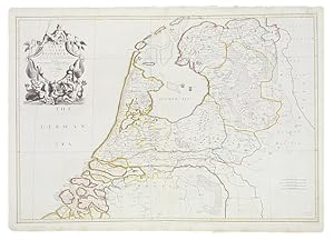
The VII United Provinces Corrected from the observations communicted to the Royal Society at London and the Royal Academy at Paris.
Data di pubblicazione: 1709
Da: Shapero Rare Books, London, Regno Unito
Membro dell'associazione: ABA ILAB PBFA
Valutazione del venditore 5 su 5 stelle
Mappa
EUR 536,16
Spedizione EUR 17,35
Spedito da Regno Unito a U.S.A.Quantit�: 1 disponibili
Aggiungi al carrelloDouble-page engraved map, printed on two sheets, joined, hand-coloured in outline, extending west to east from 'Middelburgh' to 'Lingen' and north to south from Dockum to Gelde.
-

Germany corrected from the Observations of the Royal Society at London and the Royal Academy at Paris.
Data di pubblicazione: 1710
Da: Shapero Rare Books, London, Regno Unito
Membro dell'associazione: ABA ILAB PBFA
Valutazione del venditore 5 su 5 stelle
Mappa
EUR 536,16
Spedizione EUR 17,35
Spedito da Regno Unito a U.S.A.Quantit�: 1 disponibili
Aggiungi al carrelloDouble-page engraved map, printed on two sheets, hand-coloured in outline, extending west to east from London to Warsaw and north to south from 'Sleswick' to Venice. 705 x 980 mm (27.75 x 38.5 inches).
