

Importo totale (1 articolo articoli):
Destinazione ordine:

railway poster (5 risultati)
Vai alla pagina principale dei risultati di ricerca
Filtri di ricerca
Tipo di articolo
- Tutti i tipi di prodotto
- Libri (1)
- Riviste e Giornali (Nessun altro risultato corrispondente a questo perfezionamento)
- Fumetti (Nessun altro risultato corrispondente a questo perfezionamento)
- Spartiti (Nessun altro risultato corrispondente a questo perfezionamento)
- Arte, Stampe e Poster (2)
- Fotografie (Nessun altro risultato corrispondente a questo perfezionamento)
- Mappe (2)
- Manoscritti e Collezionismo cartaceo (Nessun altro risultato corrispondente a questo perfezionamento)
Condizioni Maggiori informazioni
- Nuovo (Nessun altro risultato corrispondente a questo perfezionamento)
- Come nuovo, Ottimo o Quasi ottimo (3)
- Molto buono o Buono (Nessun altro risultato corrispondente a questo perfezionamento)
- Discreto o Mediocre (Nessun altro risultato corrispondente a questo perfezionamento)
- Come descritto (2)
Legatura
- Tutte
- Rilegato (Nessun altro risultato corrispondente a questo perfezionamento)
- Brossura (1)
Ulteriori caratteristiche
- Prima ed. (Nessun altro risultato corrispondente a questo perfezionamento)
- Copia autograf. (Nessun altro risultato corrispondente a questo perfezionamento)
- Sovracoperta (Nessun altro risultato corrispondente a questo perfezionamento)
- Con foto (5)
- Non Print on Demand (5)
Lingua (2)
Prezzo
- Qualsiasi prezzo
- Inferiore a EUR 20 (Nessun altro risultato corrispondente a questo perfezionamento)
- EUR 20 a EUR 45
- Superiore a EUR 45
Spedizione gratuita
Paese del venditore
Valutazione venditore
-
Japan's Total Empire: Manchuria and the Culture of Wartime Imperialism
Lingua: Inglese
Editore: University of California Press, Berkeley, California, 1999
Da: Vero Beach Books, Vero Beach, FL, U.S.A.
Valutazione del venditore 5 su 5 stelle

Soft cover. Condizione: Fine. Junto, Ito (cover illustration: Manchurian Railway poster; Burger, Nola (cover design) (illustratore). Fine unread condition color illustrated softcover wraps. Includes Author Dedication; List of Map and Tables; Acknowledgments; Note on Sources; Conclusion; The Paradox of Total Empire; Bibliography; Index; and Studies of the East Asian Institute: Selected Titles. Illustrated with map. "One of the most important books in Japanese history to appear in several years.Young provocatively concludes that Japanese authoritarianism and empire-building from 1931 to 1945 were products of the nation's modernization . An uncommonly successful book with a big thesis." - Sheldon Garon, Monumenta Nipponica. "Young's extraordinary book will force historians of Japan to rethink their treatment of Manchukuo. Young's study also joins the new comparative scholarship on imperialism, which analyzes its transforming power not only on the colony but also on the metropole. She has thus created an essential work of scholarship for students of comparative imperialist history." - Parks M. Coble, American Historical Review. "What makes this book especially compelling is the author's ability to pursue .interpretative themes within a riveting narrative that holds the reader's interest from cover to cover. A gem of historical research, which . significantly enriches our understanding of Japan as an imperial power." - Stephen Large, Japanese Studies. "In well-organized chapters and lucic prose, this excellent cultural history shows how Japanese military, economic, and social imperialism in Manchuria affected the colonizer as well as the colonized. Enriching her study with evidence from a wide range of popular magazines and newspapers and making judicious use of the Japanese secondary literature, Young retells the familiar story of the 1931 seizure of Manchuria in the context of Japan's mass culture, illuminating how Japanese society joined the state in the production of empire .Young has contributed significantly to understanding state and society in wartime Japan." - S.A. Hastings, Choice. ABOUT THE AUTHOR: Louise Young is Assistant Professor of History at New York University and Winner, John K. Fairbank Prize of the American Historical Association and Hiromi Arisawa Award of the American Association of University Presses.
-
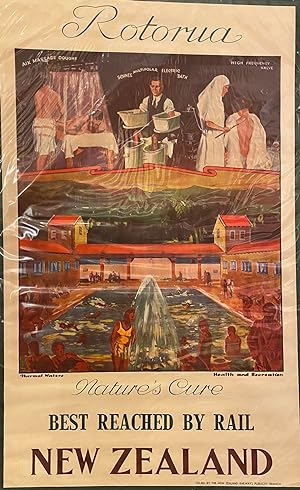
Rotorua, Natures Cure. Best reached by rail. New Zealand
Lingua: Inglese
Editore: New Zealand Railways, Wellington
Da: Anah Dunsheath RareBooks ABA ANZAAB ILAB, Auckland, NZ, Nuova Zelanda
Membro dell'associazione: ABA ANZAAB ILAB
Valutazione del venditore 5 su 5 stelle
Arte / Stampa / Poster
EUR 991,61
Spedizione EUR 21,84
Spedito da Nuova Zelanda a U.S.A.Quantità: 1 disponibili
Aggiungi al carrelloNo Binding. Condizione: Near Fine. 1020 x 63 cm c1930s. Stunning original tourism poster of Rotorua, New Zealand Free floating in mylar. Shows a colourful images of Aix massage douche, Schnee Multipolar electric bath, high Frequency valve. thermal baths. Rare.
-
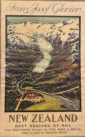
Franz Josef Gacier
Lingua: Inglese
Editore: New Zealand Railways, Wellington, 1932
Da: Anah Dunsheath RareBooks ABA ANZAAB ILAB, Auckland, NZ, Nuova Zelanda
Membro dell'associazione: ABA ANZAAB ILAB
Valutazione del venditore 5 su 5 stelle
Arte / Stampa / Poster
EUR 1.577,55
Spedizione EUR 21,84
Spedito da Nuova Zelanda a U.S.A.Quantità: 1 disponibili
Aggiungi al carrelloNo Binding. Condizione: Near Fine. E M Lovell-Smith (illustratore). 1020 x 63 cm. Lithographed by Coulls Somerville Wilkie, Christchurch. FIne coloured poster detailing features of the glacier, showing hotel, tracks, etc. Very minor faults on margins. Rare.
-

1906 Auvergne Lyonnais : Paris Lyon - Mediterranee
Da: New World Cartographic, Chicago, IL, U.S.A.
Membro dell'associazione: ABAA ILAB
Valutazione del venditore 4 su 5 stelle

Mappa
By: Frederic Hugo d'AlesiDate: 1906 (edition) ParisDimensions: 40 x 28 inches (101.5 x 71 cm)One of the last works by French painter and illustrator F. Hugo d'Alesi before his death in 1906. This lithograph poster / map was created by F. Hugo d'Alesi to promote tourism by rail through the French Alps. The map extends from Moulins in the north to Clermont-Ferrand in the west, and Valence, Lyon, and Macon along the Rhone River in the East. The mountainous topography is illustrated with the use of color ranging from green river valleys to white mountain summits. Towns are connected by railroad lines, and auto routes, with proposed line and lines under construction noted throughout. A key below the map describes other line patterns and markings such as tunnels, mountainous road passes, secondary railroads, etc.Condition: This map is in A condition, linen backed for preservation purposes.Inventory #112151200 W. 35th Street #425 Chicago, IL 60609 | P: (312) 496 - 3622.
-

Chemins de Fer de l'Ouest. Excursions sur les Cotes de Normandie en Bretagne et a l'Ile de Jersey.
Data di pubblicazione: 1890
Da: Geographicus Rare Antique Maps, Brooklyn, NY, U.S.A.
Membro dell'associazione: ABAA ESA ILAB
Valutazione del venditore 4 su 5 stelle
Mappa
Very good. Laid down on linen, possibly original. Size 40.5 x 28.25 Inches. This stunning promotional chromolithograph travel poster of Normandy and Brittany, France, was prepared by A. Maulde et Cie for the Chemins de Fer de l'Ouest (Railroad of the West). Produced in a highly distinctive fin-de-siècle style, it reflects the development of rail infrastructure and the emergence of these areas as tourist destinations in the late 19th century. A Closer Look This striking promotional poster consists of a railway map at right, a series of vignette illustrations, and several tables with information on fares and itineraries. The rail map displays the various lines of the Chemins de fer de l'Ouest network emanating from Paris. Main lines are traced in bold red lines, while secondary lines are sketched in thinner red lines, and the lines of competing railways are traced in black. In addition to rail lines, the Seine and Loire Rivers are illustrated. The dazzling vignette illustrations include: the Gare St. Lazare in Paris, the terminus of many lines originating in Normandy and Brittany (the other being Gare Montparnasse); Bagnoles de l'Orne, a popular spa resort; the spectacular abbey of Mont St. Michel; the historic walled city (and pirate haven) of St. Malo; and the posh seaside resort towns of Trouville and Deauville near the Seine Estuary, sometimes known as the 'queen of the beaches' or the 'Parisian Riviera.' Chemins de fer de l'Ouest Chemins de fer de l'Ouest began as the Compagnie de l'Ouest in 1855 when several small railways were merged, including the Paris - Le Pecq line, opened in 1837 as France's first purely passenger rail line. The company's lines served a few distinct purposes and groups of passengers, from daily commuters in Paris' western suburbs to long-distance travelers, the latter including summer tourists heading to resort towns on the English Channel or the Atlantic Coast. Larger cities like Le Havre, Rennes, and Nantes were connected with Paris by the early 1850s, and more cities acquired stops along the lines in the following decades. Normandy and Brittany became increasingly popular tourist destinations in the late 19th century in large part thanks to the railways, as well as a growing middle class in Paris and other cities, and the championing of the regions in the work of leading writers and artists of the day, such as Victor Hugo (1802 - 1885), Gustave Flaubert (1821 - 1880, who was from Rouen), and Marcel Proust (1871 - 1922, who set much of his masterpiece À la recherche du temps perdu in Normandy's beachside resorts). Despite these solid bases for revenue and their eye-catching advertisements, such as that seen here, the company ran into financial and operational problems around the turn of the century. In an infamous 1895 derailment, a train running late came into Gare Montparnasse at far too high a speed, plowed through the buffer stop at the end of the track, and right on through the station's wall, leading to the locomotive falling one story to the street below. A photograph of the crash taken by the firm Lévy and Sons became one of the most famous in transportation history, but the incident badly harmed the company's reputation. A more enduring problem was that passenger traffic on the line was highly seasonal, thriving in the summer months but moribund the rest of the year, with the company's lines mostly passing through sparsely inhabited farmland on the way to beachside resort towns. Thus, in 1908, the company was nationalized and merged into the Chemins de fer de l'État, which itself became part of the newly-formed SNCF (Société nationale des chemins de fer français) in 1938. Chromolithography Chromolithography, sometimes called oleography, is a color lithographic technique developed in the mid-19th century. The process involved using multiple lithographic stones, one for each color, to yield a rich composite effect. Oftentimes, the process would start with a black basecoat upon which s.


