Rapkin drawn (5 risultati)
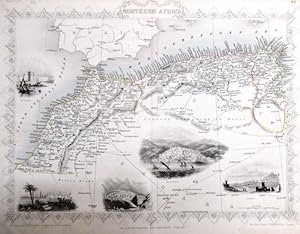
steal engraving / Grenzcolorierter Stahlstich Northern Africa. Mit weiteren 5 Bildstahlstichen 1)Mogador. 2) Marocco. 3) Constantine. 4) Algiers. 5)Tunis.
Martin, R.M. (Hrsg.) - Winkles, H. (ill) /Greatbach,G. (engraved) / Rapkin, John (The Map Drawn & Engraved by):
Lingua: Inglese
Editore: The London Printing and Publishing Company. o.J. [ca 1850], 1850
- Brossura
- Prima edizione
Da: Antiquariat Carl Wegner, Berlin, B, GermaniaAntiquariat Carl Wegner
Contatta il venditoreVenditore con 5 stelleMembro dell’associazione: GIAQ
Condizione: Usato
EUR 17,70
EUR 9,00 spedizioneSpedito da Germania a U.S.A.Quantità: 1 disponibili
Softcover. Blattgröße 27x36 cm, Stichgröße 21 x 30 cm, mittig längs gefaltet. Die Tafel mit floraler Rahmung, eingezeichneten Längen- und Breitengraden und Maßstabsangabe. Das Blatt an den Rändern und in der Querfalte leicht lichtrandig und fingerfleckig, an der linken unteren Ecke eine Faltstelle, sonst schönes Exemplar. --- In… english language. Good condition. Die Tafel beschriftet mit der Ziffer 61. Wahrscheinlich die entsprechende Tafel aus dem Werk von John Tallis: Illustrated atlas and modern history of the world. -- Zu dekorativen Zwecken, zum Rahmen geeignet. Weitere Karten aus dem gleichen Werk vorhanden. "John Rapkin was a mapmaker who was concerned with the aesthetic value of his work as well as cartographic content. His fine maps are distinguished by the trademark decorative borders, vignettes and title displays. Rapkin worked in close association with the equally respected publisher John Tallis. The publishing rights of many of the maps passed to The London Printing and Publishing Company circa 1850. " -- Bitte Portokosten außerhalb EU erfragen! / Please ask for postage costs outside EU! / S ' il vous plait demander des frais de port en dehors de l ' UE! // Bitte beachten Sie auch unsere Fotos! / Please also note our photos! / Veuillez noter nos photos -- Ob Sonnenschein oder warmer Regen: mit einem interessanten Buch kommen Sie immer gut durch den Tag. -- Wir kaufen Ihre werthaltigen Bücher! GM25-502030.
 Altre immagini
Lingua: Inglese
Editore: H. Lamb & Son, Malvern
- Rilegato
- Mappa
Da: J. R. Young, Birmingham, Regno UnitoJ. R. Young
Contatta il venditoreVenditore con 5 stelleCondizione: Usato - Buono
EUR 150,32
EUR 24,52 spedizioneSpedito da Regno Unito a U.S.A.Quantità: 1 disponibili
Hardcover. Condizione: Good. Partly coloured circular map on smooth closely-woven thin white fabric. No date (mid- to later-19th century). On square sheet of sides 42.5cm, folding up into 12 segments. In original green cloth binding 15x11cm, lined on inside with grey-green paper; covers with blindstamped decorations, front title…d in gilt. Map lightly spotted, blank verso also lightly dust-marked over one or two segments. Binding here & there a little faded, and damp-stained to a darker tone towards lower inner corner of front cover - nothing too disfiguring. Paper along inner hinge partly split. Binding holding and of decent appearance, map in good order. Overall condition GOOD.

Editore: The London Printing and Publishing Company, 1850
- Mappa
Da: AMBRA BOOKS (Aitchison & Cornish), Bristol, Regno UnitoAMBRA BOOKS (Aitchison & Cornish)
Contatta il venditoreVenditore con 3 stelleCondizione: Usato
EUR 60,13
EUR 22,18 spedizioneSpedito da Regno Unito a U.S.A.Quantità: 1 disponibili
Size 14" x 18", decorative border, 8 vignette views around the edge, including Railway Station, School of Design. Central fold. Streets named. --- Please e-mail for one of my FREE CATALOGUES which include WARWICKSHIRE [ Manuscripts, Maps, Ephemera, Views, etc., etc. ] -- -.

Editore: TALLIS 1850, 1850
Da: PROCTOR / THE ANTIQUE MAP & BOOKSHOP, DORCHESTER, Regno UnitoPROCTOR / THE ANTIQUE MAP & BOOKSHOP
Contatta il venditoreVenditore con 5 stelleMembro dell’associazione: PBFA
Condizione: Usato
EUR 132,28
EUR 23,35 spedizioneSpedito da Regno Unito a U.S.A.Quantità: 1 disponibili
Size 10.5 x 14 inches. Hand Coloured Engraving. In good condition. Some light tanning, small tear & crease lower edge, tiny loss top left margin corner. Two small tape repairs on verso of centre fold. An attractive and decorative mapwith stunning vignette engravings in the borders. Drawn engraved by John Rapkin for The Illustrat…ed Atlas and Modern History of the World by Martin Montgomery.

England & Wales
J & E Tallis. Map drawn & engraved by J Rapkin. The illustrations drawn by N Whittock and engraved by J Rogers.
- Mappa
Da: theoldmapman, Clevedon, SOMER, Regno Unitotheoldmapman
Contatta il venditoreVenditore con 5 stelleCondizione: Usato - Molto buono
EUR 119,05
EUR 7,59 spedizioneSpedito da Regno Unito a U.S.A.Quantità: 1 disponibili
No Binding. Condizione: Very Good. Original antique map with original hand colouring of the county boundaries as issued. Vignettes of London, Oxford, Portsmouth Harbour, Sunderland Bridge, Newcastle-upon-Tyne, Doncaster Races and Hunting. The border is topped by the Royal coat of arms and with drawings in the corners showing agr…iculture, commerce, science and the arts. Early edition without centrefold. Full margins all round. Toned verso but not showing on the face. Sold with ivory bevelled mount and a single ruling. Mount window 25.5 x 35.5. Overall size 35.5 x 45.5. The size of the mount makes it a Medium Parcel so shipping in UK £6. Shipped without mount, if preferred. 26.5 x 37 cm.


