Importo totale (1 articolo articoli):
Destinazione ordine:

saxton kip (64 risultati)
Vai alla pagina principale dei risultati di ricerca
Filtri di ricerca
Tipo di articolo
- Tutti i tipi di prodotto
- Libri (19)
- Riviste e Giornali (Nessun altro risultato corrispondente a questo perfezionamento)
- Fumetti (Nessun altro risultato corrispondente a questo perfezionamento)
- Spartiti (Nessun altro risultato corrispondente a questo perfezionamento)
- Arte, Stampe e Poster (Nessun altro risultato corrispondente a questo perfezionamento)
- Fotografie (Nessun altro risultato corrispondente a questo perfezionamento)
- Mappe (45)
- Manoscritti e Collezionismo cartaceo (Nessun altro risultato corrispondente a questo perfezionamento)
Condizioni Maggiori informazioni
- Nuovo (Nessun altro risultato corrispondente a questo perfezionamento)
- Come nuovo, Ottimo o Quasi ottimo (2)
- Molto buono o Buono (15)
- Discreto o Mediocre (1)
- Come descritto (46)
Legatura
Ulteriori caratteristiche
- Prima ed. (23)
- Copia autograf. (Nessun altro risultato corrispondente a questo perfezionamento)
- Sovracoperta (Nessun altro risultato corrispondente a questo perfezionamento)
- Con foto (54)
- Non Print on Demand (64)
Lingua (2)
Spedizione gratuita
- Spedizione gratuita in U.S.A. (Nessun altro risultato corrispondente a questo perfezionamento)
Paese del venditore
Valutazione venditore
-

Map of HUNTINGDON,
Lingua: Inglese
Editore: 1637, 1637
Da: THOMAS RARE BOOKS, Yaxley, SUFFOLK, Regno Unito
Valutazione del venditore 4 su 5 stelle

EUR 59,63
Spedizione EUR 17,37
Spedito da Regno Unito a U.S.A.Quantit�: 1 disponibili
Aggiungi al carrelloNo Binding. Condizione: Fine. 2nd ediiton. Hand-colour. 13x11 inches,
-
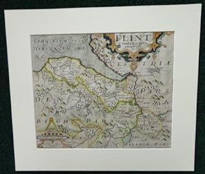
Flint Comitatus
Lingua: Inglese
Data di pubblicazione: 1637
Da: Madoc Books (ABA-ILAB), Llandudno, CONWY, Regno Unito
Membro dell'associazione: ABA ILAB IOBA PBFA
Valutazione del venditore 5 su 5 stelle

Mappa
EUR 89,45
Spedizione EUR 34,74
Spedito da Regno Unito a U.S.A.Quantit�: 1 disponibili
Aggiungi al carrelloBoards. Condizione: Very Good. William Kip (illustratore). Actual Map size 31.5*26 cm, mounted 42.5*37 cm, copper engraving highlighted in colour by hand, with a decorative title cartouche, Scala Miliarium and shaded seas, center crease. Saxton, Christopher, map maker and in producing a complete set of county maps of England and Wales, brought to fruition an idea that had been long germinating. Map-consciousness had been growing in the minds of statesmen, developing simultaneously with surveying techniques. Saxton's county maps gained instant recognition at the highest political levels-even while they were still in course of production, between 1574 and 1578, Lord Burghley pulled and annotated early proofs. Saxton's maps were planimetrically superior to those of his predecessors. See ODNB for a full Bio.
-

Dunelmensis Episcopatus Qui Comitatus Est Palatinus Olim Pars Brigantum
Lingua: Inglese
Editore: George Bishop & John Norton, London, UK, 1607
Da: Hornseys, Ripon, Regno Unito
Membro dell'associazione: PBFA
Valutazione del venditore 5 su 5 stelle
EUR 149,08
Spedizione EUR 28,95
Spedito da Regno Unito a U.S.A.Quantit�: 1 disponibili
Aggiungi al carrelloNo Binding. Condizione: Very Good Plus. 2nd Edition. Original copper-engraved map. Sheet size: 39.7cm x 32.4cm. Blank to the verso. Remnants of old tabs to the good, wide margins. Minor age toning and browning but in very good plus, bright, clean condition overall and a good, strong impression.
-

Dunelmensis Episcopatus
Lingua: Inglese
Data di pubblicazione: 1637
Da: Hornseys, Ripon, Regno Unito
Membro dell'associazione: PBFA
Valutazione del venditore 5 su 5 stelle
EUR 77,52
Spedizione EUR 28,95
Spedito da Regno Unito a U.S.A.Quantit�: 1 disponibili
Aggiungi al carrelloNo Binding. Condizione: Very Good. Original copper engraving. Date: 1637. Sheet size: 34.6cm x 30cm. Early hand-colouring. Close-cropped with very minor age-spotting. Central fold line. In very good, bright, clean condition.
-
Mongomery [Original Hand-Colored Engraved Map]:. Comitatus qui olim pars Ordouicum
Editore: Camden?s Britannia, 1637
Da: Lux Mentis, Booksellers, ABAA/ILAB, Portland, ME, U.S.A.
Membro dell'associazione: ABAA ILAB MABA MBS
Valutazione del venditore 4 su 5 stelle
Condizione: Near Fine. Hand coloured map of Montgomery County in Wales. This map was originally published in Camden's Britannia which was the first in which each county was printed on a separate sheet. The first issue of the series was in 1607 (with Latin text at verso) with two editions in 1610 and 1637. The later two had not text on the back and plate numbers may be found on the 1637 issue. Toning notwithstanding, a lovely example with wide margins remaining in an elegant black enamel and gilt frame. Light, even toning, else bright and clean. Hand coloured map. Approximately 15x13" overall, image is 10.5x12.5".
-
Lincolniae Comitatus ubi olim Insederunt Coritani [Map of Lincolnshire]
Editore: [Published by George Bishop & John Norton] no date givenc1607-1620, [London], 1607
Da: Keoghs Books, Skipton, Regno Unito
Membro dell'associazione: PBFA
Valutazione del venditore 5 su 5 stelle
Mappa Prima edizione
EUR 357,78
Spedizione EUR 32,42
Spedito da Regno Unito a U.S.A.Quantit�: 1 disponibili
Aggiungi al carrello, hand-coloured map of Lincolnshire with black titles, decorative title with scale of miles to upper right hand corner (Scala Miliarium Anglocorum to 10, Sculp), single border (including towns, rivers, forests, hills), watermark (grapes with coronet), imprint derived from atlas (from William Camden's Britannia with Latin text 'Lincolne-shire' with initial to left-hand side of reverse) First Edition , slight wear to edges with some tape, amateur repair with tape to reverse of upper left-hand corner, fold line, faint foxing, good condition , paper 32.5 x 39 cms Paperback ISBN:
-

DUNELMENSIS Episcopatus qui comitatus est Palatinus olim pars BRIGANTUM'. Map of the County of Durham.
Editore: c., 1637
Da: Bristow & Garland, Shaftesbury, Regno Unito
Valutazione del venditore 4 su 5 stelle
EUR 83,48
Spedizione EUR 16,21
Spedito da Regno Unito a U.S.A.Quantit�: 1 disponibili
Aggiungi al carrelloEngraved map with contemporary colouring. 15 x 12 inches, Latin text to the reverse. Some marginal browning, overall light tanning. Generally very good.
-
![Immagine del venditore per [Essex]. Essexia comitatvs, qvem olim trinobantes tenuerunt continens in se opida marcatoria. venduto da Robert Frew Ltd. ABA ILAB](https://pictures.abebooks.com/inventory/md/md30894930063.jpg)
[Essex]. Essexia comitatvs, qvem olim trinobantes tenuerunt continens in se opida marcatoria.
Editore: LondonImpensis Georgii Bishop & Ioannis Norton ., 1610
Da: Robert Frew Ltd. ABA ILAB, London, Regno Unito
Membro dell'associazione: ABA ILAB PBFA
Valutazione del venditore 5 su 5 stelle
Mappa Prima edizione
EUR 89,45
Spedizione EUR 11,58
Spedito da Regno Unito a U.S.A.Quantit�: 1 disponibili
Aggiungi al carrelloOriginal uncoloured engraved map of Essex showing parts of London in bottom right corner, trimmed to neatline and backed onto 18th century laid paper. Map dimensions 28.5 x 36.5 cm, overall backing-sheet size 32 x 40 cm. Small losses near upper centre and bottom right corner, a bit toned overall and with a few trivial blemishes. An early decorative map of Essex engraved by William Kip based on the earlier maps by Elizabethan cartographer Christopher Saxton first published in the 1607 edition of William Camden's Britannia.* This example is from the first English edition of Camden's Britannia published in 1610, without any text on the verso. Embellished with decorative cartouche. *Britannia, first published in 1586, was one of the most popular and influential books of the period. The work of the Elizabethan antiquarian, William Camden (1551-1623), it was a detailed historical and topographical description of Great Britain. Its patriotic sentiments, in particular, both appealed to and generated the growing sense of nationalism that was coursing through late Tudor / early Stuart society. Between 1607 and 1637, county maps engraved by William Kip and William Hole, and based largely on Saxton's surveys, were added. (Skelton, 6).
-
![Immagine del venditore per [Befordshire]. Bedford Comitatus olim pars Cathifuclanorum. venduto da Robert Frew Ltd. ABA ILAB](https://pictures.abebooks.com/inventory/md/md30894927370.jpg)
[Befordshire]. Bedford Comitatus olim pars Cathifuclanorum.
Editore: LondonImpensis Georgii Bishop & Ioannis Norton ., 1610
Da: Robert Frew Ltd. ABA ILAB, London, Regno Unito
Membro dell'associazione: ABA ILAB PBFA
Valutazione del venditore 5 su 5 stelle
Mappa Prima edizione
EUR 89,45
Spedizione EUR 11,58
Spedito da Regno Unito a U.S.A.Quantit�: 1 disponibili
Aggiungi al carrelloOriginal uncoloured engraved map of Bedfordshire trimmed to neatline and backed onto 18th century laid paper. Map dimensions 27.5 x 33 cm, overall backing-sheet size 32 x 40 cm. Rather soiled along right hand margin (mainly to backing-sheet), small tears to lower margin of backing sheet with old paper repair to verso, a bit unevenly toned, small losses to lower right corner. An early decorative map of Bedfordshire engraved by William Kip based on the earlier maps by Elizabethan cartographer Christopher Saxton first published in the 1607 edition of William Camden's Britannia.* This example is from the first English edition of Camden's Britannia published in 1610, without any text on the verso. Embellished with compass rose and decorative cartouche. *Britannia, first published in 1586, was one of the most popular and influential books of the period. The work of the Elizabethan antiquarian, William Camden (1551-1623), it was a detailed historical and topographical description of Great Britain. Its patriotic sentiments, in particular, both appealed to and generated the growing sense of nationalism that was coursing through late Tudor / early Stuart society. Between 1607 and 1637, county maps engraved by William Kip and William Hole, and based largely on Saxton's surveys, were added. (Skelton, 6).
-
![Immagine del venditore per [Staffordshire]. Staffordi� Comitatvs pars olim cornauiorum. venduto da Robert Frew Ltd. ABA ILAB](https://pictures.abebooks.com/inventory/md/md30894927368.jpg)
[Staffordshire]. Staffordi� Comitatvs pars olim cornauiorum.
Editore: LondonImpensis Georgii Bishop & Ioannis Norton ., 1610
Da: Robert Frew Ltd. ABA ILAB, London, Regno Unito
Membro dell'associazione: ABA ILAB PBFA
Valutazione del venditore 5 su 5 stelle
Mappa Prima edizione
EUR 119,26
Spedizione EUR 11,58
Spedito da Regno Unito a U.S.A.Quantit�: 1 disponibili
Aggiungi al carrelloOriginal uncoloured engraved map of Staffordshire trimmed to neatline and backed onto 18th century laid paper. Map dimensions 27 x 37.5 cm, overall backing-sheet size 32 x 40 cm. Smudged overall and with a bit of browning. An early decorative map of Staffordshire engraved by William Kip based on the earlier maps by Elizabethan cartographer Christopher Saxton first published in the 1607 edition of William Camden's Britannia.* This example is from the first English edition of Camden's Britannia published in 1610, without any text on the verso. Embellished with decorative cartouche and compass dividers. *Britannia, first published in 1586, was one of the most popular and influential books of the period. The work of the Elizabethan antiquarian, William Camden (1551-1623), it was a detailed historical and topographical description of Great Britain. Its patriotic sentiments, in particular, both appealed to and generated the growing sense of nationalism that was coursing through late Tudor / early Stuart society. Between 1607 and 1637, county maps engraved by William Kip and William Hole, and based largely on Saxton's surveys, were added. (Skelton, 6).
-
![Immagine del venditore per [Denbighshire]. Denbigh Comitatus pas olim Ordovicvm. venduto da Robert Frew Ltd. ABA ILAB](https://pictures.abebooks.com/inventory/md/md30894927366.jpg)
[Denbighshire]. Denbigh Comitatus pas olim Ordovicvm.
Editore: LondonImpensis Georgii Bishop & Ioannis Norton ., 1610
Da: Robert Frew Ltd. ABA ILAB, London, Regno Unito
Membro dell'associazione: ABA ILAB PBFA
Valutazione del venditore 5 su 5 stelle
Mappa Prima edizione
EUR 119,26
Spedizione EUR 11,58
Spedito da Regno Unito a U.S.A.Quantit�: 1 disponibili
Aggiungi al carrelloOriginal uncoloured engraved map of Denbighshire trimmed to neatline and backed onto 18th century laid paper. Map dimensions 27 x 32 cm, overall backing-sheet size 32 x 40 cm. 13 cm split down middle, minimal toning and spotting. An early decorative map of Denbighshire engraved by William Hole based on the earlier maps by Elizabethan cartographer Christopher Saxton first published in the 1607 edition of William Camden's Britannia.* This example is from the first English edition of Camden's Britannia published in 1610, without any text on the verso. *Britannia, first published in 1586, was one of the most popular and influential books of the period. The work of the Elizabethan antiquarian, William Camden (1551-1623), it was a detailed historical and topographical description of Great Britain. Its patriotic sentiments, in particular, both appealed to and generated the growing sense of nationalism that was coursing through late Tudor / early Stuart society. Between 1607 and 1637, county maps engraved by William Kip and William Hole, and based largely on Saxton's surveys, were added. (Skelton, 6).
-
![Immagine del venditore per [Radnorshire]. Radnor Comitatus quem silvres olim Incolucrunt. venduto da Robert Frew Ltd. ABA ILAB](https://pictures.abebooks.com/inventory/md/md30894927364.jpg)
[Radnorshire]. Radnor Comitatus quem silvres olim Incolucrunt.
Editore: LondonImpensis Georgii Bishop & Ioannis Norton ., 1610
Da: Robert Frew Ltd. ABA ILAB, London, Regno Unito
Membro dell'associazione: ABA ILAB PBFA
Valutazione del venditore 5 su 5 stelle
Mappa Prima edizione
EUR 119,26
Spedizione EUR 11,58
Spedito da Regno Unito a U.S.A.Quantit�: 1 disponibili
Aggiungi al carrelloOriginal uncoloured engraved map of Radnorshire trimmed to neatline and backed onto 18th century laid paper. Map dimensions 27 x 32 cm, overall backing-sheet size 32 x 40 cm. Minimal toning and spotting, generally very good. An early decorative map of Radnorshire engraved by William Kip based on the earlier maps by Elizabethan cartographer Christopher Saxton first published in the 1607 edition of William Camden's Britannia.* This example is from the first English edition of Camden's Britannia published in 1610, without any text on the verso. *Britannia, first published in 1586, was one of the most popular and influential books of the period. The work of the Elizabethan antiquarian, William Camden (1551-1623), it was a detailed historical and topographical description of Great Britain. Its patriotic sentiments, in particular, both appealed to and generated the growing sense of nationalism that was coursing through late Tudor / early Stuart society. Between 1607 and 1637, county maps engraved by William Kip and William Hole, and based largely on Saxton's surveys, were added. (Skelton, 6).
-

Flint Comitatus quem ordovices olim incoluerunt
Editore: London, 1607
Da: Clive A. Burden Ltd., Chalfont St. Giles, BUCKS, Regno Unito
Membro dell'associazione: ABA ILAB
Valutazione del venditore 5 su 5 stelle
Mappa
EUR 113,30
Spedizione EUR 25,65
Spedito da Regno Unito a U.S.A.Quantit�: 1 disponibili
Aggiungi al carrelloNo binding. 265 x 320 mm., in good condition. This is from an edition of William Camden's 'Britannia' first published in 1586. It was the last to be published in his lifetime and the first to be illustrated with county maps although this had been contemplated since at least 1589. Camden (1551-1623) was an antiquary and historian. An academic by profession he would become the headmaster of Westminster School in 1593. He spent much of his time travelling and collecting material for his highly respected 'Britannia'. This is engraved by William Kip and is from the first fully illustrated edition of William Camden's classic work, this example from the preferred second edition without text to the verso. Chubb 18; Evans (1964) MCC no. 13 p. 6; Shirley BL T.Camd 1b; Skelton 5; STC 4508; Taylor 'Late Tudor and Early Stuart Geography' pp. 9- 13.
-
![Immagine del venditore per [Montgomeryshire]. Mongomery Comitatus qui olim pars Ordouicum venduto da Robert Frew Ltd. ABA ILAB](https://pictures.abebooks.com/inventory/md/md30894931927.jpg)
[Montgomeryshire]. Mongomery Comitatus qui olim pars Ordouicum
Editore: LondonImpensis Georgii Bishop & Ioannis Norton ., 1610
Da: Robert Frew Ltd. ABA ILAB, London, Regno Unito
Membro dell'associazione: ABA ILAB PBFA
Valutazione del venditore 5 su 5 stelle
Mappa Prima edizione
EUR 149,08
Spedizione EUR 11,58
Spedito da Regno Unito a U.S.A.Quantit�: 1 disponibili
Aggiungi al carrelloOriginal uncoloured engraved map of Montgomeryshire trimmed to neatline and backed onto 18th century laid paper. Map dimensions 27 x 32 cm, overall backing-sheet size 32 x 40 cm. Minimal toning and spotting, generally very good. An early decorative map of Montgomeryshire engraved by William Kip based on the earlier maps by Elizabethan cartographer Christopher Saxton first published in the 1607 edition of William Camden's Britannia.* This example is from the first English edition of Camden's Britannia published in 1610, without any text on the verso. *Britannia, first published in 1586, was one of the most popular and influential books of the period. The work of the Elizabethan antiquarian, William Camden (1551-1623), it was a detailed historical and topographical description of Great Britain. Its patriotic sentiments, in particular, both appealed to and generated the growing sense of nationalism that was coursing through late Tudor / early Stuart society. Between 1607 and 1637, county maps engraved by William Kip and William Hole, and based largely on Saxton's surveys, were added. (Skelton, 6).
-
![Immagine del venditore per [Brecknockshire]. Brecknoc comitatus pars olim Silurum. venduto da Robert Frew Ltd. ABA ILAB](https://pictures.abebooks.com/inventory/md/md30894923693.jpg)
[Brecknockshire]. Brecknoc comitatus pars olim Silurum.
Editore: LondonImpensis Georgii Bishop & Ioannis Norton ., 1610
Da: Robert Frew Ltd. ABA ILAB, London, Regno Unito
Membro dell'associazione: ABA ILAB PBFA
Valutazione del venditore 5 su 5 stelle
Mappa Prima edizione
EUR 149,08
Spedizione EUR 11,58
Spedito da Regno Unito a U.S.A.Quantit�: 1 disponibili
Aggiungi al carrelloOriginal uncoloured engraved map of Brecknockshire trimmed to neatline and backed onto 18th century laid paper. Map dimensions 27 x 32 cm, overall backing-sheet size 32 x 40 cm. 2 cracks to plate in centre of map and one to bottom right, some light smudging and toning especially to backing-sheet. An early decorative map of Brecknockshire engraved by William Kip based on the earlier maps by Elizabethan cartographer Christopher Saxton first published in the 1607 edition of William Camden's Britannia.* This example is from the first English edition of Camden's Britannia published in 1610, without any text on the verso. *Britannia, first published in 1586, was one of the most popular and influential books of the period. The work of the Elizabethan antiquarian, William Camden (1551-1623), it was a detailed historical and topographical description of Great Britain. Its patriotic sentiments, in particular, both appealed to and generated the growing sense of nationalism that was coursing through late Tudor / early Stuart society. Between 1607 and 1637, county maps engraved by William Kip and William Hole, and based largely on Saxton's surveys, were added. (Skelton, 6).
-
![Immagine del venditore per [Cardiganshire]. Cardigan Comitatus pars olim Dimetarvm. venduto da Robert Frew Ltd. ABA ILAB](https://pictures.abebooks.com/inventory/md/md30894923692.jpg)
[Cardiganshire]. Cardigan Comitatus pars olim Dimetarvm.
Editore: LondonImpensis Georgii Bishop & Ioannis Norton ., 1610
Da: Robert Frew Ltd. ABA ILAB, London, Regno Unito
Membro dell'associazione: ABA ILAB PBFA
Valutazione del venditore 5 su 5 stelle
Mappa Prima edizione
EUR 149,08
Spedizione EUR 11,58
Spedito da Regno Unito a U.S.A.Quantit�: 1 disponibili
Aggiungi al carrelloOriginal uncoloured engraved map of Cardiganshire trimmed to neatline and backed onto 18th century laid paper. Map dimensions 27 x 32 cm, overall backing-sheet size 32 x 40 cm. 2 small (3 cm) cracks to plate, two brown spots to backing-sheet, minor toning. An early decorative map of Cardiganshire engraved by William Hole based on the earlier maps by Elizabethan cartographer Christopher Saxton first published in the 1607 edition of William Camden's Britannia.* This example is from the first English edition of Camden's Britannia published in 1610, without any text on the verso. The map is embellished by a compass rose, compass dividers, two decorative cartouches, and a sea galleon. *Britannia, first published in 1586, was one of the most popular and influential books of the period. The work of the Elizabethan antiquarian, William Camden (1551-1623), it was a detailed historical and topographical description of Great Britain. Its patriotic sentiments, in particular, both appealed to and generated the growing sense of nationalism that was coursing through late Tudor / early Stuart society. Between 1607 and 1637, county maps engraved by William Kip and William Hole, and based largely on Saxton's surveys, were added. (Skelton, 6).
-
![Immagine del venditore per [Leicestershire]. Leicestri� sive Leicestershyre, pars olim coritanorvm. venduto da Robert Frew Ltd. ABA ILAB](https://pictures.abebooks.com/inventory/md/md30894930981.jpg)
[Leicestershire]. Leicestri� sive Leicestershyre, pars olim coritanorvm.
Editore: LondonImpensis Georgii Bishop & Ioannis Norton ., 1610
Da: Robert Frew Ltd. ABA ILAB, London, Regno Unito
Membro dell'associazione: ABA ILAB PBFA
Valutazione del venditore 5 su 5 stelle
Mappa Prima edizione
EUR 149,08
Spedizione EUR 11,58
Spedito da Regno Unito a U.S.A.Quantit�: 1 disponibili
Aggiungi al carrelloOriginal uncoloured engraved map of Leicestershire trimmed to neatline and backed onto 18th century laid paper. Map dimensions 28.5 x 36 cm, overall backing-sheet size 32 x 40 cm. A bit unevenly toned, faintly browned near margins, generally very good. An early decorative map of Leicestershire engraved by William Kip based on the earlier maps by Elizabethan cartographer Christopher Saxton first published in the 1607 edition of William Camden's Britannia.* This example is from the first English edition of Camden's Britannia published in 1610, without any text on the verso. The maps of the 1610 edition of Britannia can be found in one of three states. This example lacks the compass rose present in the first alteration (State II) of the Cornwall map, indicating it's early state (Skelton, 29). *Britannia, first published in 1586, was one of the most popular and influential books of the period. The work of the Elizabethan antiquarian, William Camden (1551-1623), it was a detailed historical and topographical description of Great Britain. Its patriotic sentiments, in particular, both appealed to and generated the growing sense of nationalism that was coursing through late Tudor / early Stuart society. Between 1607 and 1637, county maps engraved by William Kip and William Hole, and based largely on Saxton's surveys, were added. (Skelton, 6).
-
![Immagine del venditore per [Flintshire]. Flint Comitatus quem ordovices olim Incolucrunt. venduto da Robert Frew Ltd. ABA ILAB](https://pictures.abebooks.com/inventory/md/md30894928221.jpg)
[Flintshire]. Flint Comitatus quem ordovices olim Incolucrunt.
Editore: LondonImpensis Georgii Bishop & Ioannis Norton ., 1610
Da: Robert Frew Ltd. ABA ILAB, London, Regno Unito
Membro dell'associazione: ABA ILAB PBFA
Valutazione del venditore 5 su 5 stelle
Mappa Prima edizione
EUR 149,08
Spedizione EUR 11,58
Spedito da Regno Unito a U.S.A.Quantit�: 1 disponibili
Aggiungi al carrelloOriginal uncoloured engraved map of Flintshire trimmed to neatline and backed onto 18th century laid paper. Map dimensions 27 x 32 cm, overall backing-sheet size 32 x 40 cm. Minimal toning and spotting, generally very good. An early decorative map of Flintshire engraved by William Kip based on the earlier maps by Elizabethan cartographer Christopher Saxton first published in the 1607 edition of William Camden's Britannia.* This example is from the first English edition of Camden's Britannia published in 1610, without any text on the verso. *Britannia, first published in 1586, was one of the most popular and influential books of the period. The work of the Elizabethan antiquarian, William Camden (1551-1623), it was a detailed historical and topographical description of Great Britain. Its patriotic sentiments, in particular, both appealed to and generated the growing sense of nationalism that was coursing through late Tudor / early Stuart society. Between 1607 and 1637, county maps engraved by William Kip and William Hole, and based largely on Saxton's surveys, were added. (Skelton, 6).
-

Cardigan comitatus pars Olim Dimetarum
Editore: London, 1607
Da: Clive A. Burden Ltd., Chalfont St. Giles, BUCKS, Regno Unito
Membro dell'associazione: ABA ILAB
Valutazione del venditore 5 su 5 stelle
Mappa
EUR 137,15
Spedizione EUR 25,65
Spedito da Regno Unito a U.S.A.Quantit�: 1 disponibili
Aggiungi al carrelloNo binding. 265 x 315 mm., in good condition. The first printed map of Cardigan from the first fully illustrated edition of William Camden's classic work, the 'Britannia'. An example of the FIRST STATE from the second and preferred edition of 1610 without text to the verso. Refer to Skelton no. 5.
-

Huntingdon comitatus.
Editore: London, Georgii Bishop & Ioannis Norton, 1607-10. 275 x 340mm (10� x 13� inches)., 1610
Da: Tooley, Adams & Co., Wallingford, OXON, Regno Unito
Valutazione del venditore 4 su 5 stelle
Prima edizione
EUR 143,11
Spedizione EUR 43,01
Spedito da Regno Unito a U.S.A.Quantit�: 1 disponibili
Aggiungi al carrelloUncoloured; light toning in the margins, otherwise a very good example. A map of the county from the first English edition of the 'Britannia', translated by Phil�mon Holland. Engraved by William Kip, from the Christopher Saxton survey of 1576. The Saxton map is of Northants/Beds/Cambs/Hunts and Rutland, therefore this example is one of the earliest separate printed maps of the county.
-

Bedford comitatus.
Editore: London, Georgii Bishop & Ioannis Norton, 1607-10. 275 x 340mm (10� x 13� inches)., 1610
Da: Tooley, Adams & Co., Wallingford, OXON, Regno Unito
Valutazione del venditore 4 su 5 stelle
Prima edizione
EUR 143,11
Spedizione EUR 43,01
Spedito da Regno Unito a U.S.A.Quantit�: 1 disponibili
Aggiungi al carrelloUncoloured; light toning in the margins, short centrefold split (repaired). otherwise a very good example. A map of the county from the first English edition of the 'Britannia', translated by Phil�mon Holland. Engraved by William Kip, from the Christopher Saxton survey of 1576. The Saxton map is of Northants/Beds/Cambs/Hunts and Rutland, therefore this example is one of the earliest separate printed maps of the county.State III with plate number 15, bottom left corner.
-

Brecknoc comitaus pars.
Editore: London, 1607-10. 270 x 315mm (10� x 12� inches)., 1610
Da: Tooley, Adams & Co., Wallingford, OXON, Regno Unito
Valutazione del venditore 4 su 5 stelle
Prima edizione
EUR 155,04
Spedizione EUR 43,01
Spedito da Regno Unito a U.S.A.Quantit�: 1 disponibili
Aggiungi al carrelloUncoloured; very light toning in the margins, slight cockling of paper around the centrefold, otherwise a very good example. A map of the county from the first English edition of the 'Britannia', translated by Phil�mon Holland. Engraved by Robert Vaughan, from the Christopher Saxton survey of 1578. The Saxton map is of Radnor/Brecon/Cardigan and Carmarthen, therefore this example is one of the earliest separate printed maps of the county.
-

Dunelmensis Episcopatus qui comitatus est Palatinus olim pars Brigantum
Editore: London, 1607
Da: Clive A. Burden Ltd., Chalfont St. Giles, BUCKS, Regno Unito
Membro dell'associazione: ABA ILAB
Valutazione del venditore 5 su 5 stelle
Mappa
EUR 178,89
Spedizione EUR 25,65
Spedito da Regno Unito a U.S.A.Quantit�: 1 disponibili
Aggiungi al carrelloNo binding. 280 x 335 mm., light soiling upper corner, otherwise in good condition. The first printed map of Durham from William Camden's 'Britannia'. This is from the seventh edition of William Camden's 'Britannia' first published in 1586. It was the last to be published in his lifetime and the first series to be illustrated with county maps, although this had been contemplated since at least 1589. Camden (1551-1623) was an antiquary and historian. An academic by profession he would become the headmaster of Westminster School in 1593. He spent much of his time travelling and collecting material for his highly respected 'Britannia'. An example of the second state from the second edition without text on the verso. Chubb 19; Shirley BL T.Camd 1c; Skelton 6; Taylor 'Late Tudor and Early Stuart Geography' pp. 9- 13.
-

Cumbria sive Cumberlandia .
Editore: London, 1607
Da: Clive A. Burden Ltd., Chalfont St. Giles, BUCKS, Regno Unito
Membro dell'associazione: ABA ILAB
Valutazione del venditore 5 su 5 stelle
Mappa
EUR 190,82
Spedizione EUR 25,65
Spedito da Regno Unito a U.S.A.Quantit�: 1 disponibili
Aggiungi al carrelloNo binding. Condizione: Good. 290 x 320 mm., trimmed along the lower margin, otherwise in good condition. The first printed map of Cumberland from William Camden's 'Britannia'. This is from the seventh edition of William Camden's 'Britannia' first published in 1586. It was the last to be published in his lifetime and the first to be illustrated with county maps although this had been contemplated since at least 1589. Camden (1551-1623) was an antiquary and historian. An academic by profession he would become the headmaster of Westminster School in 1593. He spent much of his time travelling and collecting material for his highly respected 'Britannia'. An example of the preferred first state from the second edition without text on the verso. Chubb 18; Higham pp. 15-16; Shirley BL T.Camd 1c; Skelton 5; Taylor 'Late Tudor and Early Stuart Geography' pp. 9- 13.
-
![Immagine del venditore per Wiltoniae Comitatus herbida Planiciae nobiis vulgo willshire pars olim Belgarum [Wiltshire]. venduto da Michael S. Kemp, Bookseller](https://pictures.abebooks.com/inventory/md/md32077497798.jpg)
Wiltoniae Comitatus herbida Planiciae nobiis vulgo willshire pars olim Belgarum [Wiltshire].
Editore: [1637], 1637
Da: Michael S. Kemp, Bookseller, Sheerness, KENT, Regno Unito
Membro dell'associazione: PBFA
Valutazione del venditore 5 su 5 stelle
Mappa
EUR 166,96
Spedizione EUR 46,31
Spedito da Regno Unito a U.S.A.Quantit�: 1 disponibili
Aggiungi al carrelloCopper engraved map with hand colouring, 285 x 355 mm. with broad margins. Framed and glazed.
-

Cambridge Comitatus quem olim Iceni Insederunt
Editore: London, 1607
Da: Clive A. Burden Ltd., Chalfont St. Giles, BUCKS, Regno Unito
Membro dell'associazione: ABA ILAB
Valutazione del venditore 5 su 5 stelle
Mappa
EUR 190,82
Spedizione EUR 25,65
Spedito da Regno Unito a U.S.A.Quantit�: 1 disponibili
Aggiungi al carrelloNo binding. 280 x 320 mm., in excellent condition. The first printed map of Cambridgeshire from William Camden's 'Britannia', the first fully illustrated edition of his classic work. An example of the second state from the third edition. Refer to Skelton no. 5.
-

Northamtoniae Comitatus �
Editore: London, 1607
Da: Clive A. Burden Ltd., Chalfont St. Giles, BUCKS, Regno Unito
Membro dell'associazione: ABA ILAB
Valutazione del venditore 5 su 5 stelle
Mappa
EUR 190,82
Spedizione EUR 25,65
Spedito da Regno Unito a U.S.A.Quantit�: 1 disponibili
Aggiungi al carrelloNo binding. 280 x 360 cms., in fine condition. From the first fully illustrated edition of Camden's classic work, the 'Britannia'. An example of the third state. Refer to Skelton no. 5.
-

Cambridge Comitatus quem olim Iceni Insederunt
Editore: London, 1607
Da: Clive A. Burden Ltd., Chalfont St. Giles, BUCKS, Regno Unito
Membro dell'associazione: ABA ILAB
Valutazione del venditore 5 su 5 stelle
Mappa
EUR 190,82
Spedizione EUR 25,65
Spedito da Regno Unito a U.S.A.Quantit�: 1 disponibili
Aggiungi al carrelloNo binding. 280 x 320 mm., light water stain upper corners away from the image, in good condition. This is from the sixth edition of William Camden's 'Britannia' first published in 1586. It was the last to be published in his lifetime and the first to be illustrated with county maps although this had been contemplated since at least 1589. Camden (1551-1623) was an antiquary and historian. An academic by profession he would become the headmaster of Westminster School in 1593. He spent much of his time travelling and collecting material for his highly respected 'Britannia'. The first printed map of Cambridgeshire from William Camden's 'Britannia', the first fully illustrated edition of his classic work. An example of the second state from the third edition. Chubb 18; Shirley BL T.Camd 1e; Skelton 5; STC 4508; Taylor 'Late Tudor and Early Stuart Geography' pp. 9- 13.
-

Notingamiae Comitatus olim Pars Coritaniorum
Editore: London, 1607
Da: Clive A. Burden Ltd., Chalfont St. Giles, BUCKS, Regno Unito
Membro dell'associazione: ABA ILAB
Valutazione del venditore 5 su 5 stelle
Mappa Prima edizione
EUR 190,82
Spedizione EUR 25,65
Spedito da Regno Unito a U.S.A.Quantit�: 1 disponibili
Aggiungi al carrelloNo binding. 260 x 310 mm., small split in lower margin, not affecting the image, with Latin text to the verso, in good condition. The first printed map of Nottinghamshire from the first fully illustrated edition of William Camden's classic work, the 'Britannia'. An example of the FIRST STATE from the FIRST edition. Refer to Skelton no. 5.
-

Dunelmensis Episcopatus qui comitatus est Palatinus olim pars Brigantum
Editore: London, 1607
Da: Clive A. Burden Ltd., Chalfont St. Giles, BUCKS, Regno Unito
Membro dell'associazione: ABA ILAB
Valutazione del venditore 5 su 5 stelle
Mappa
EUR 190,82
Spedizione EUR 25,65
Spedito da Regno Unito a U.S.A.Quantit�: 1 disponibili
Aggiungi al carrelloNo binding. 280 x 335 mm., nice dark impression, in good condition. The first printed map of Durham from William Camden's 'Britannia'. This is from the seventh edition of William Camden's 'Britannia' first published in 1586. It was the last to be published in his lifetime and the first series to be illustrated with county maps, although this had been contemplated since at least 1589. Camden (1551-1623) was an antiquary and historian. An academic by profession he would become the headmaster of Westminster School in 1593. He spent much of his time travelling and collecting material for his highly respected 'Britannia'. An example of the preferred first state from the second edition without text on the verso. Chubb 19; Shirley BL T.Camd 1c; Skelton 6; Taylor 'Late Tudor and Early Stuart Geography' pp. 9- 13.