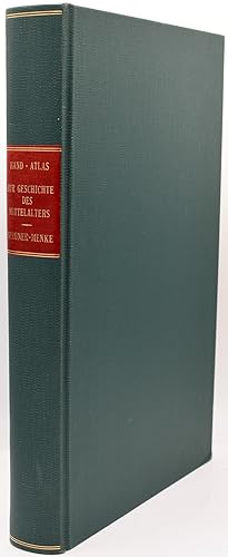
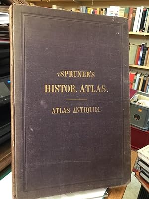
Spruner menke (36 risultati)

Editore: Gotha Justus Perthes 1880
- Rilegato
Da: Antiquariat Heuberger (VDA / ILAB), Köln, GermaniaAntiquariat Heuberger (VDA / ILAB)
Contatta il venditoreVenditore con 4 stelleCondizione: Usato
EUR 120,00
EUR 35,00 spedizioneSpedito da Germania a U.S.A.Quantità: 1 disponibili
55 Seiten, 90 doppelblattgr. kolorierte Karten, Gr4° (39,8 x 25,9 cm), Orig.-Halblederband (Rücken fehlt, Deckel lose) mit vergold. Deckeltitel. Vorsätze und Titel mit alten Rundstempeln eines Wiener Gymnasiums, ebenso die Karten am unteren Rand. Die ersten 48 Karten am unteren Rand gleichmäßig eingerissen. - Die Karten sind fle…ckenfrei und in einem schönen Kolorit. Sprache: Deutsch.
Editore: Gotha, Perthes, 1854 u. 1856. 1854
- Rilegato
Da: Antiquariat Kunsthaus-Adlerstrasse, Stuttgart, GermaniaAntiquariat Kunsthaus-Adlerstrasse
Contatta il venditoreVenditore con 5 stelleCondizione: Usato
EUR 202,00
EUR 11,95 spedizioneSpedito da Germania a U.S.A.Quantità: 1 disponibili
Durchgehend mit XVII und XXII ganzseitigen Karten. Einb. mit Gebrauchsspuren, Vorsatz u. Titelblatt mit Knickspuren, Vermerk auf Vorsatz, Seiten etw. fingerfl. u. teilw. braunfl. Sprache: Deutsch Quer-4°, goldgepr. Orig.-Halbleder.
 Altre immagini
Editore: Justus Perthes, Gotha 1880
- Rilegato
Da: BLACK SWAN BOOKS, INC., ABAA, ILAB, Richmond, VA, U.S.A.BLACK SWAN BOOKS, INC., ABAA, ILAB
Contatta il venditoreVenditore con 5 stelleCondizione: Usato
EUR 226,05
EUR 9,22 spedizioneSpedito in U.S.A.Quantità: 1 disponibili
Hard Cover. Condizione: Near Fine binding. Folio; rebound in green cloth with titling in gold to the spine; [ii],[2], 3-42 pages, followed by 89 of 90 double-paged maps [NOTE: this copy appears to be lacking Map VIII: Europa wahrend des Zeitraums der Reformation und der Uebermachtdes Hauses Hapsburgh 1492-1618]; the maps are ste…el-engraved, with coloring to the borders of the countries; one maps in color lithography.~~This copy is bound quite tightly -- so tightly that it does not lie flat when opened and to the extent that some text and perhaps some part of maps are down in the gutter. Near Fine binding.
Editore: Gothae : Sumtibus Justi Perthes, Gothae : Sumtibus Justi Perthes 1865
- Rilegato
Da: Pierre de RONSARD, CHÉDIGNY, FR, FranciaPierre de RONSARD
Contatta il venditoreVenditore con 5 stelleCondizione: Usato
EUR 280,00
EUR 8,00 spedizioneSpedito da Francia a U.S.A.Quantità: 1 disponibili
17 pages de texte en allemand, imprimé sur 2 colonnes, avec 31 planches de cartes sur pages doubles, montées sur onglets et délicatement rehaussées ; couverture ornée des titres en lettres dorées ; dos à 4 nerfs avec filets et titres or ; toutes tranches mouchetées bleues. in-folio Faibles taches sur le dernier plat, coiffes un…peu usées avec petit manque de cuir, sinon excellent état. relié, demi-cuir marron à coins, et plats de toile bleue.
 Altre immagini
Editore: Gotha, Justus Perthes 1880
- Rilegato
Da: Magnus, Paris, FranciaMagnus
Contatta il venditoreVenditore con 4 stelleCondizione: Usato - Quasi ottimo
EUR 450,00
EUR 29,00 spedizioneSpedito da Francia a U.S.A.Quantità: 1 disponibili
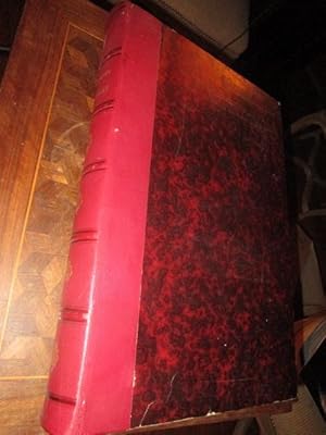
Couverture rigide. Condizione: Bon. 3ème Édition. 3. Auflage, Roter Halb Leder Einband der Zeit, fest, Titel mit Bünden am Rücken, sehr guter Zustand, nur an Kanten leicht berieben; schöne marmorierte Vorsätze; 90 colorierte Karten in Kupferstich mit 376 Nebenkarten, 42 Seiten, Schönes Exemplar ohne Benutzungspuren. Die Karten s…ind datiert von 1871 bis 1879, alle gut erhalten und ohne Flecken; Gewicht um 5 kg.; sehr gut erhaltenes ex.
Editore: Justus Perthes Verlag Gotha 1880 1880
- Rilegato
Da: Andrew Barnes Books / Military Melbourne, Melbourne, VIC, AustraliaAndrew Barnes Books / Military Melbourne
Contatta il venditoreVenditore con 4 stelleCondizione: Usato
EUR 515,38
EUR 17,56 spedizioneSpedito da Australia a U.S.A.Quantità: 1 disponibili
3rd edition 3/4 leather Nice copy folio 42pp., colour maps, With 90 double-page colour maps. Beautifully bound by Peter Zerber in 3/4 burgundy leather over royal blue linen boards. Five raised bands at spine with a black leather title label.
Editore: Justus Perthes, Gotha 1874
Da: Asia Bookroom ANZAAB/ILAB, Canberra, ACT, AustraliaAsia Bookroom ANZAAB/ILAB
Contatta il venditoreVenditore con 5 stelleCondizione: Usato
EUR 77,91
EUR 18,65 spedizioneSpedito da Australia a U.S.A.Quantità: 1 disponibili
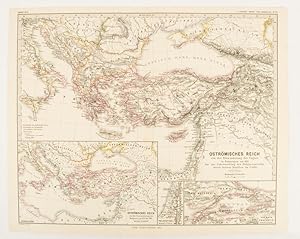
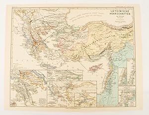
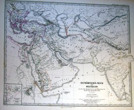
Map with original colour and outline hand-colour, 32.2 x 40 cm, three inset maps, text in German, central fold, slight marginal toning, in very good condition. A most handsome map detailing the Eastern Roman Empire from the immigration of Hungarians in Ponnonia around 895 to the subjugation of the Bulgarian Empire by Emperor Bas…ilius in 1019. The inset maps depict Divisions of the Empire, Palestine, and the Themata around Propontis (present day Sea of Marmara), issued for the "Hand-Atlas für die Geschichte des Mittelatters und die Neueren Zeit".
Editore: Justus Perthes, Gotha 1877
Da: Asia Bookroom ANZAAB/ILAB, Canberra, ACT, AustraliaAsia Bookroom ANZAAB/ILAB
Contatta il venditoreVenditore con 5 stelleCondizione: Usato
EUR 77,91
EUR 18,65 spedizioneSpedito da Australia a U.S.A.Quantità: 1 disponibili
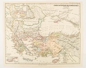
Map with original colour and outline hand-colour, 32.2 x 40 cm, two inset maps, text in German, central fold, in very good condition. A most handsome map detailing countries on the Aegean and Black Seas 1311 to 1390. The inset maps depict the kingdom of Stephan Duschan (Serbia) and the land of the Crimean Goths, issued for the "…Hand-Atlas für die Geschichte des Mittelatters und die Neueren Zeit".
Editore: Justus Perthes, Gotha 1876
Da: Asia Bookroom ANZAAB/ILAB, Canberra, ACT, AustraliaAsia Bookroom ANZAAB/ILAB
Contatta il venditoreVenditore con 5 stelleCondizione: Usato
EUR 77,91
EUR 18,65 spedizioneSpedito da Australia a U.S.A.Quantità: 1 disponibili
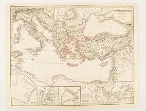
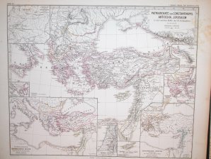
Map with original colour and outline hand-colour, 32.2 x 40 cm, text in German, four inset maps, central fold, slight marginal toning, and spotting on the verso, but in very good condition. A most handsome and highly detailed map detailing the Eastern provinces of the Byzantine/Roman Empire before the Fourth Crusade. The inset m…aps depict Constantinople, Divisions of the Empire, and Antioch, issued for the "Hand-Atlas für die Geschichte des Mittelatters und die Neueren Zeit".
Editore: Justus Perthes, Gotha 1877
Da: Asia Bookroom ANZAAB/ILAB, Canberra, ACT, AustraliaAsia Bookroom ANZAAB/ILAB
Contatta il venditoreVenditore con 5 stelleCondizione: Usato
EUR 77,91
EUR 18,65 spedizioneSpedito da Australia a U.S.A.Quantità: 1 disponibili
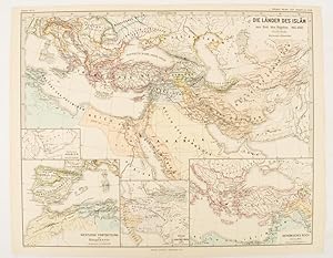
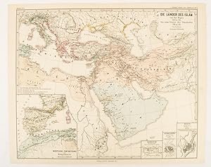
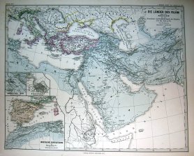
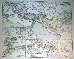
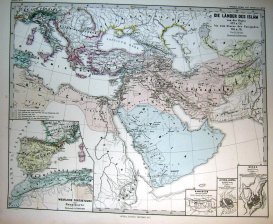
Map with original colour and outline hand-colour, 32.7 x 40.7 cm, four inset maps, text in German, central fold, slight marginal edge wear and spotting to the verso, but in very good condition. A handsome map detailing the lands of Islam at the time of the Bujids 945-1055. The inset maps depict a western extension to the main ma…p, southern Arabia, the lands of the Ghaznavid sultanate in Central Asia, and lands of the Eastern Roman/Byzantine Empire, issued for the "Hand-Atlas für die Geschichte des Mittelatters und die Neueren Zeit".
Editore: Justus Perthes, Gotha 1877
Da: Asia Bookroom ANZAAB/ILAB, Canberra, ACT, AustraliaAsia Bookroom ANZAAB/ILAB
Contatta il venditoreVenditore con 5 stelleCondizione: Usato
EUR 77,91
EUR 18,65 spedizioneSpedito da Australia a U.S.A.Quantità: 1 disponibili
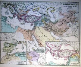
Map with original colour and outline hand-colour, 32.2 x 40 cm, three inset maps, text in German, central fold, slight marginal toning, in very good condition. A most handsome map detailing the lands of Islam under the Abbasids up to the capture of Baghdâd by the Bûjids from 750 to 945 AD. The inset maps depict Northern Iraq, Ba…ghdad, and a western continuation of the main map, issued for the "Hand-Atlas für die Geschichte des Mittelatters und die Neueren Zeit".
Editore: Justus Perthes., Gotha.
Da: Asia Bookroom ANZAAB/ILAB, Canberra, ACT, AustraliaAsia Bookroom ANZAAB/ILAB
Contatta il venditoreVenditore con 5 stelleCondizione: Usato
EUR 77,91
EUR 18,65 spedizioneSpedito da Australia a U.S.A.Quantità: 1 disponibili
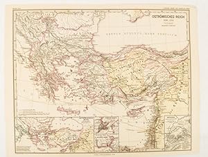
Map with original colour and outline hand-colour, 32.2 x 40 cm, text in German, five inset maps, central fold, slight marginal toning, and spotting on the verso, but in very good condition. A most handsome and highly detailed map detailing the Eastern provinces of the Byzantine/Roman Empire in the time of the Roman Emperor Justi…nian 527-565. The inset maps depict Carthage, Rome, Constantinople, Naples, and a Western continuation of the main map, originally issued for the "Hand-Atlas für die Geschichte des Mittelatters und die Neueren Zeit".
Editore: Justus Perthes, Gotha 1876
Da: Asia Bookroom ANZAAB/ILAB, Canberra, ACT, AustraliaAsia Bookroom ANZAAB/ILAB
Contatta il venditoreVenditore con 5 stelleCondizione: Usato
EUR 77,91
EUR 18,65 spedizioneSpedito da Australia a U.S.A.Quantità: 1 disponibili
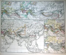
Map with original colour and outline hand-colour, 32.2 x 40 cm, seven inset maps, text in German, central fold, slight marginal toning, in very good condition. A most handsome and highly detailed map detailing provinces of the Latin Empire in the wake of the Crusades. The inset maps depict Achaia in Greece, Divisions of the Empi…re, and a city plan of Constantinople, issued for the "Hand-Atlas für die Geschichte des Mittelatters und die Neueren Zeit".
Editore: Justus Perthes, Gotha 1877
Da: Asia Bookroom ANZAAB/ILAB, Canberra, ACT, AustraliaAsia Bookroom ANZAAB/ILAB
Contatta il venditoreVenditore con 5 stelleCondizione: Usato
EUR 77,91
EUR 18,65 spedizioneSpedito da Australia a U.S.A.Quantità: 1 disponibili
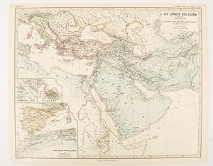
Map with original colour and outline hand-colour, 33.1 x 40.2 cm, four inset maps, text in German, central fold, slight marginal edge wear and spotting to the verso, but in very good condition. A handsome map detailing the lands of Islam from Hegra in AD 622 to the fall of the Umayyads in AD 750. The inset maps depict a western…extension to the main map and city plans for Damascus, Jathrib & Medina, and Mecca, issued for the "Hand-Atlas für die Geschichte des Mittelatters und die Neueren Zeit".
 Altre immagini
Lingua: Tedesco
Editore: Gotha, Perthes, 1854 1854 ( MDCCLIV ). 1854
- Rilegato
- Stampa artistica
Da: Allgäuer Online Antiquariat, Memmingen, DE, GermaniaAllgäuer Online Antiquariat
Contatta il venditoreVenditore con 5 stelleMembro dell’associazione: GIAQ
Condizione: Usato - Molto buono
EUR 110,00
EUR 40,00 spedizioneSpedito da Germania a U.S.A.Quantità: 1 disponibili
4°, Halbleinen m. Titelprägung. Condizione: Gut. 2. Aufl. ( edition secunda ). 4 Bl., mit XVII ganzseitigen Karten. Die Karten granzkoloriert. Buch u. Karten in gutem Zustand Sprache: Deutsch Gewicht in Gramm: 300.
Lingua: Tedesco
Editore: Gotha: Perthes, 1865
- Rilegato
Da: Antiquariat Hecht, Leer, NDS, GermaniaAntiquariat Hecht
Contatta il venditoreVenditore con 5 stelleMembro dell’associazione: GIAQ
Condizione: Usato - Molto buono
EUR 198,90
EUR 31,00 spedizioneSpedito da Germania a U.S.A.Quantità: 1 disponibili
Condizione: Gut. Tertio editit Theodor Menke.. 17 S. Erläuterungen zu den folgenden 31 doppelseitigen farbigen Karten; Dritte (3.) Ausgabe / Auflage; Einband berieben und bestoßen, kl. Fehlstellen an d. Kapitalen, im Block sehr guter Zustand. (Schlagwörter: Atlas, Kartenwerk, Geschichtsatlas) /atlas Sprache: Deutsch Gewicht in G…ramm: 2100 2°; gebunden, Orig.-Leinen mit Goldprägung.

Lingua: Tedesco
Editore: Justus Perthes, Gotha 1855
- Rilegato
Da: Gurra's Books, Hemse, SveziaGurra's Books
Contatta il venditoreVenditore con 5 stelleCondizione: Usato - Molto buono
EUR 1650,00
EUR 128,00 spedizioneSpedito da Svezia a U.S.A.Quantità: 1 disponibili
Hardcover. Condizione: Very Good. 2nd Edition. Covers moderately worn, scratched and soiled. Signs of erased sticker (?) on fpds. Bss seemingly slightly sunned. Maps in as new condition. Vol I: 17 pp + XXXI map spreads. 3rd edition, no py, supposedly 1865. Vol II: (ii) + 42 pp + 90 map spreads. 3rd edition, 1880. Vol. III: (ii)…+ 12 pp + XVIII map spreads. 2nd edition, 1855. Elephant folio. 353 pp. 7015 grams. German.
 Altre immagini
- Rilegato
Da: Herman H. J. Lynge & Søn ILAB-ABF, Copenhagen, DanimarcaHerman H. J. Lynge & Søn ILAB-ABF
Contatta il venditoreVenditore con 4 stelleCondizione: Usato
EUR 165,29
EUR 42,00 spedizioneSpedito da Danimarca a U.S.A.Quantità: 1 disponibili
Gothae, Sumtibus Justi Perthes, 1865. Folio (380 x 260 mm). In the original embossed cloth binding with gilt lettering to front board. Spine and boarders og boards faded. Previous owners names to upper outer corner of front free end-paper. Internally with few occassional brownspots but generally nice and clean. 17 pp. + 31 folde…d coloured maps.
Editore: Gotha 1877
- Stampa artistica
Da: Frame, Madrid, M, SpagnaFrame
Contatta il venditoreVenditore con 5 stelleCondizione: Usato - Buono
EUR 185,00
EUR 50,00 spedizioneSpedito da Spagna a U.S.A.Quantità: 1 disponibili
Condizione: ACEPTABLE. Atlas Spruner-Menke, 1880 Gotha : Justus Perthes. 1877 Incluye pequeño mapa de España Formato (cm): 46x38.
Editore: Gotha 1876
- Stampa artistica
Da: Frame, Madrid, M, SpagnaFrame
Contatta il venditoreVenditore con 5 stelleCondizione: Usato - Buono
EUR 185,00
EUR 50,00 spedizioneSpedito da Spagna a U.S.A.Quantità: 1 disponibili
Condizione: ACEPTABLE. Atlas Spruner-Menke, 1880 Gotha : Justus Perthes. 1876 Formato (cm): 46x38.
Editore: Gotha 1877
- Stampa artistica
Da: Frame, Madrid, M, SpagnaFrame
Contatta il venditoreVenditore con 5 stelleCondizione: Usato - Buono
EUR 185,00
EUR 50,00 spedizioneSpedito da Spagna a U.S.A.Quantità: 1 disponibili
Condizione: ACEPTABLE. Atlas Spruner-Menke, 1880 Gotha : Justus Perthes. 1877 Incluye pequeño mapa de España Formato (cm): 46x38.
Editore: Gotha 1877
- Stampa artistica
Da: Frame, Madrid, M, SpagnaFrame
Contatta il venditoreVenditore con 5 stelleCondizione: Usato - Buono
EUR 185,00
EUR 50,00 spedizioneSpedito da Spagna a U.S.A.Quantità: 1 disponibili
Condizione: ACEPTABLE. Atlas Spruner-Menke, 1880 Gotha : Justus Perthes. 1877 Formato (cm): 46x38.
Editore: Gotha 1871
- Stampa artistica
Da: Frame, Madrid, M, SpagnaFrame
Contatta il venditoreVenditore con 5 stelleCondizione: Usato - Buono
EUR 185,00
EUR 50,00 spedizioneSpedito da Spagna a U.S.A.Quantità: 1 disponibili
Condizione: ACEPTABLE. Atlas Spruner-Menke, 1880 Gotha : Justus Perthes. 1871 Formato (cm): 46x38.

Editore: Gotha 1876
- Stampa artistica
Da: Frame, Madrid, M, SpagnaFrame
Contatta il venditoreVenditore con 5 stelleCondizione: Usato - Buono
EUR 185,00
EUR 50,00 spedizioneSpedito da Spagna a U.S.A.Quantità: 1 disponibili
Condizione: ACEPTABLE. Atlas Spruner-Menke, 1880 Gotha : Justus Perthes. 1876 Formato (cm): 46x38.
Editore: Gotha 1877
- Stampa artistica
Da: Frame, Madrid, M, SpagnaFrame
Contatta il venditoreVenditore con 5 stelleCondizione: Usato - Buono
EUR 185,00
EUR 50,00 spedizioneSpedito da Spagna a U.S.A.Quantità: 1 disponibili
Condizione: ACEPTABLE. Atlas Spruner-Menke, 1880 Gotha : Justus Perthes. 1877 Incluye pequeño mapa de España Formato (cm): 46x38.
Editore: Gotha 1871
- Stampa artistica
Da: Frame, Madrid, M, SpagnaFrame
Contatta il venditoreVenditore con 5 stelleCondizione: Usato - Buono
EUR 225,00
EUR 50,00 spedizioneSpedito da Spagna a U.S.A.Quantità: 1 disponibili
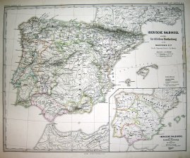
Condizione: ACEPTABLE. Atlas Spruner-Menke, 1880 Gotha : Justus Perthes. 1871 Incluye un pequeño mapa de Navarra y Vascongadas y otro de Portugal Formato (cm): 46x38.
Editore: Gotha 1871
- Stampa artistica
Da: Frame, Madrid, M, SpagnaFrame
Contatta il venditoreVenditore con 5 stelleCondizione: Usato - Buono
EUR 225,00
EUR 50,00 spedizioneSpedito da Spagna a U.S.A.Quantità: 1 disponibili
Condizione: ACEPTABLE. Atlas Spruner-Menke, 1880 Gotha : Justus Perthes. 1871 Formato (cm): 46x38.
Editore: Gotha 1871
- Stampa artistica
Da: Frame, Madrid, M, SpagnaFrame
Contatta il venditoreVenditore con 5 stelleCondizione: Usato - Buono
EUR 225,00
EUR 50,00 spedizioneSpedito da Spagna a U.S.A.Quantità: 1 disponibili
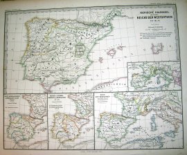
Condizione: ACEPTABLE. Atlas Spruner-Menke, 1880 Gotha : Justus Perthes. 1871 Incluye 4 pequeños mapas de España con parte de Europa Formato (cm): 46x38.
Editore: Gotha 1871
- Stampa artistica
Da: Frame, Madrid, M, SpagnaFrame
Contatta il venditoreVenditore con 5 stelleCondizione: Usato - Buono
EUR 225,00
EUR 50,00 spedizioneSpedito da Spagna a U.S.A.Quantità: 1 disponibili
Condizione: ACEPTABLE. Atlas Spruner-Menke, 1880 Gotha : Justus Perthes. 1871 Formato (cm): 46x38.


