
Importo totale (1 articolo articoli):
Destinazione ordine:

thames river map stanford (2 risultati)
Vai alla pagina principale dei risultati di ricerca
Filtri di ricerca
Tipo di articolo
- Tutti i tipi di prodotto
- Libri (2)
- Riviste e Giornali (Nessun altro risultato corrispondente a questo perfezionamento)
- Fumetti (Nessun altro risultato corrispondente a questo perfezionamento)
- Spartiti (Nessun altro risultato corrispondente a questo perfezionamento)
- Arte, Stampe e Poster (Nessun altro risultato corrispondente a questo perfezionamento)
- Fotografie (Nessun altro risultato corrispondente a questo perfezionamento)
- Mappe (Nessun altro risultato corrispondente a questo perfezionamento)
- Manoscritti e Collezionismo cartaceo (Nessun altro risultato corrispondente a questo perfezionamento)
Condizioni Maggiori informazioni
- Nuovo (Nessun altro risultato corrispondente a questo perfezionamento)
- Come nuovo, Ottimo o Quasi ottimo (Nessun altro risultato corrispondente a questo perfezionamento)
- Molto buono o Buono (Nessun altro risultato corrispondente a questo perfezionamento)
- Discreto o Mediocre (Nessun altro risultato corrispondente a questo perfezionamento)
- Come descritto (2)
Legatura
- Tutte
- Rilegato (2)
- Brossura (Nessun altro risultato corrispondente a questo perfezionamento)
Ulteriori caratteristiche
- Prima ed. (Nessun altro risultato corrispondente a questo perfezionamento)
- Copia autograf. (Nessun altro risultato corrispondente a questo perfezionamento)
- Sovracoperta (Nessun altro risultato corrispondente a questo perfezionamento)
- Con foto (2)
- Non Print on Demand (2)
Lingua (1)
Prezzo
- Qualsiasi prezzo
- Inferiore a EUR 20 (Nessun altro risultato corrispondente a questo perfezionamento)
- EUR 20 a EUR 45 (Nessun altro risultato corrispondente a questo perfezionamento)
- Superiore a EUR 45
Spedizione gratuita
- Spedizione gratuita in U.S.A. (Nessun altro risultato corrispondente a questo perfezionamento)
Paese del venditore
Valutazione venditore
-
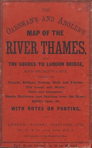
THE OARSMAN'S AND ANGLER'S MAP OF THE RIVER THAMES from the Source to London Bridge. One inch to a mile.
Editore: Edward Stanford, Ltd. London. 1912, 1912
Da: Coch-y-Bonddu Books Ltd, MACHYNLLETH, Regno Unito
Membro dell'associazione: PBFA
Valutazione del venditore 5 su 5 stelle

EUR 83,36
Spedizione EUR 11,56
Spedito da Regno Unito a U.S.A.Quantit�: 1 disponibili
Aggiungi al carrelloALL UK PARCELS SENT TRACKED! ALL OVERSEAS PARCELS SENT AIRMAIL, TRACKED! (S/hand, Hardcover, 1912). 1912. 12mo (115 x 165mm). 20 pp of text. Coloured folding paper map, (820mm x 575mm). Green cloth case with orange paper title label covering upper board. Sellotape repairs to map, some browning but good. The Oarsman's And Angler's Map Of The River Thames, from the source to London Bridge, scale one inch to a mile, shewing the islands, bridges, towing path and ferries; the locks and weirs; tolls and distances; roads, railways, and stations near the river; hotels, inns, &c., with notes on punting. Map dated 1912, but the notes pages refer to bye-laws made in January 1914. "Price: 2s. net Coloured; 4s. 6d. net Mounted." This is the cheaper coloured paper version. .
-
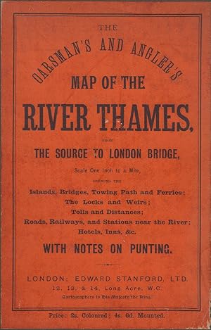
THE OARSMAN'S AND ANGLER'S MAP OF THE RIVER THAMES from the Source to London Bridge. One inch to a mile.
Editore: Edward Stanford, Ltd. London. 1912, 1912
Da: Coch-y-Bonddu Books Ltd, MACHYNLLETH, Regno Unito
Membro dell'associazione: PBFA
Valutazione del venditore 5 su 5 stelle
EUR 119,08
Spedizione EUR 11,56
Spedito da Regno Unito a U.S.A.Quantit�: 1 disponibili
Aggiungi al carrelloALL UK PARCELS SENT TRACKED! ALL OVERSEAS PARCELS SENT AIRMAIL, TRACKED! (S/hand, Hardcover, 1912). 1912. 12mo (115 x 165mm). 20 pp of text. Coloured folding paper map, (820mm x 575mm). Green cloth case with orange paper title label covering upper board. One small tear to map, some browning but very good. The Oarsman's And Angler's Map Of The River Thames, from the source to London Bridge, scale one inch to a mile, shewing the islands, bridges, towing path and ferries; the locks and weirs; tolls and distances; roads, railways, and stations near the river; hotels, inns, &c., with notes on punting. Map dated 1912, but the notes pages refer to bye-laws made in January 1914. "Price: 2s. net Coloured; 4s. 6d. net Mounted." This is the cheaper coloured paper version. .