Importo totale (1 articolo articoli):
Destinazione ordine:

bacons large print map london di bacon (10 risultati)
Feedback
Vai alla pagina principale dei risultati di ricerca
Filtri di ricerca
Tipo di articolo
- Tutti i tipi di prodotto
- Libri (8)
- Riviste e Giornali (Nessun altro risultato corrispondente a questo perfezionamento)
- Fumetti (Nessun altro risultato corrispondente a questo perfezionamento)
- Spartiti (Nessun altro risultato corrispondente a questo perfezionamento)
- Arte, Stampe e Poster (Nessun altro risultato corrispondente a questo perfezionamento)
- Fotografie (Nessun altro risultato corrispondente a questo perfezionamento)
- Mappe (2)
- Manoscritti e Collezionismo cartaceo (Nessun altro risultato corrispondente a questo perfezionamento)
Condizioni
- Tutte
- Nuovi (Nessun altro risultato corrispondente a questo perfezionamento)
- Antichi o usati (10)
Legatura
- Tutte
- Rilegato (7)
- Brossura (Nessun altro risultato corrispondente a questo perfezionamento)
Ulteriori caratteristiche
- Prima ed. (1)
- Copia autograf. (Nessun altro risultato corrispondente a questo perfezionamento)
- Sovracoperta (Nessun altro risultato corrispondente a questo perfezionamento)
- Con foto (5)
- Non Print on Demand (10)
Lingua (1)
Prezzo
- Qualsiasi prezzo
- Inferiore a EUR 20 (Nessun altro risultato corrispondente a questo perfezionamento)
- EUR 20 a EUR 45
- Superiore a EUR 45
Spedizione gratuita
- Spedizione gratuita in Italia (Nessun altro risultato corrispondente a questo perfezionamento)
Paese del venditore
Valutazione venditore
-
![Immagine del venditore per Bacon's large print map of London and suburbs [cartographic material] venduto da In 't Wasdom - antiquariaat Cornelissen & De Jong](https://pictures.abebooks.com/inventory/md/md31619480910.jpg)
Bacon's large print map of London and suburbs [cartographic material]
Editore: G.W. Bacon & Co. n.d. [1948], London, 1948
Da: In 't Wasdom - antiquariaat Cornelissen & De Jong, Notter, Paesi Bassi
Valutazione del venditore 5 su 5 stelle

EUR 24,50
Convertire valutaEUR 14,50 per la spedizione da Paesi Bassi a ItaliaQuantit�: 1 disponibili
Aggiungi al carrelloCondizione: Good. Goed. Gebonden, 40 pp. Uit de collectie van Igor Cornelissen, large print map of London and suburbs Bacon's large-print map of London and suburbs with guide. Large-print map of London and suburbs with guide Strangers' guide to London (introduction, 16 pp. + index to streets 24 pp.), sent as letter.
-
Bacon's New Large Print Map of London and Suburbs, 1948
Editore: G. W. Bacon & Co., London, 1948
Da: Kazoo Books LLC, Kalamazoo, MI, U.S.A.
Valutazione del venditore 5 su 5 stelle
EUR 20,17
Convertire valutaEUR 35,84 per la spedizione da U.S.A. a ItaliaQuantit�: 1 disponibili
Aggiungi al carrelloHardcover. Condizione: Very Good. No Jacket. Hadcover with tan illustrated covers. Some spotting on covers. 40 pages of text with fold out map attached to the book. Some tears to the map, but intact. Book is 7.5x5. Color map folds out to 36x29 inches.
-

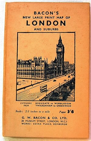
Bacon's new large print map of London and suburbs : extending from Highgate to Wimbledon, Twickenham to Greenwich
Editore: G. W. Bacon & Co. Ltd., London, 1948
Da: Antiquarius Booksellers, Falkland, BC, Canada
Valutazione del venditore 4 su 5 stelle

Prima edizione
EUR 43,94
Convertire valutaEUR 12,80 per la spedizione da Canada a ItaliaQuantit�: 1 disponibili
Aggiungi al carrelloCloth. Condizione: Good to VG+. First Edition. Cover title. Includes "Strangers' guide to London" [40pp] and folded, col.oured map (28 1/2in x 36 in.). With index to streets. Folding map, mounted on linen, is in perfect condition - very bright and, because folded, fresh. Guidebook text is near fine. Red cloth covers, ith Houses of Parl;iament to the front and the London Underground map to the back, show minor edge wear and some discoloration to the lower quarter of the front cover. Spine is sun-faded. Unpacked weight, 162g. Ships via inexpensive Canada Post Lettermail within North America, in card sleeve, $4.00 - $6.00. Images available. Enquire for rates to Worldwide destinations. Size: 19cm. Book.
-
EUR 30,76
Convertire valutaEUR 29,86 per la spedizione da U.S.A. a ItaliaQuantit�: 1 disponibili
Aggiungi al carrelloHardcover. Condizione: Very Good. No Jacket. circa 1939.
-
BACON'S LARGE PRINT MAP OF LONDON AND SUBURBS.
Editore: Ed. Map & Globe Publishers. Londres, s.a. (c. 1948, 1948
Da: FARR� Libreria Anticuaria, Barcelona, B, Spagna
Membro dell'associazione: AILA ILAB
Valutazione del venditore 5 su 5 stelle
EUR 50,00
Convertire valutaEUR 15,00 per la spedizione da Spagna a ItaliaQuantit�: 1 disponibili
Aggiungi al carrello). 19 cm. 48 p�g. + mapa a color plegado de 94,5 x 72 cm montado sobre tela. Ilustr. con grabados, en el texto. Enc. en tela. * El mapa se acompa�a de la "Strangers' guide to London", que incluye un apartado de tarifas de taxi, as� como una interesante relaci�n de lugares de inter�s de la ciudad y sus alrededores, como edificios p�blicos, museos, palacios, puentes, teatros, parques o iglesias. Contiene, asimismo, un mapa ampliado del centro urbano y otro de las estaciones y l�neas de metro. - Geograf�a. Mapas. Londres. Geograf�a. Mapas. Londres.
-
Bacon's Large Print Map of London and Suburbs
Editore: London circ, 1900
Da: John Trotter Books, London, Regno Unito
Valutazione del venditore 5 su 5 stelle
EUR 54,26
Convertire valutaEUR 17,56 per la spedizione da Regno Unito a ItaliaQuantit�: 1 disponibili
Aggiungi al carrelloFolded Linen Backed Map 35 x 25" approx. Red Cloth, Gilt Title. Advert for Chas Baker Clothing. No Index. Scuffed. Good.
-
Bacon's New Large Print Map of London and Suburbs
Editore: G.W. Bacon & Co. Ltd.
Da: Wonder Book, Frederick, MD, U.S.A.
Membro dell'associazione: ABAA ILAB
Valutazione del venditore 5 su 5 stelle
EUR 31,37
Convertire valutaEUR 21,33 per la spedizione da U.S.A. a ItaliaQuantit�: 1 disponibili
Aggiungi al carrelloCondizione: Good. Good condition. No date stated. Circa 1940. (Street Map, Tourist Guide, Landmarks).
-
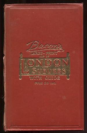
Bacon's Large-Print Map of London and Suburbs with Guide Nd C1905 Linen-Backed Map
Editore: G. W. Bacon & Co. , Ltd, London, 1905
Da: Leaf and Stone Books, Toronto, ON, Canada
Membro dell'associazione: ABAC ILAB IOBA
Valutazione del venditore 5 su 5 stelle
EUR 74,70
Convertire valutaEUR 35,84 per la spedizione da Canada a ItaliaQuantit�: 1 disponibili
Aggiungi al carrelloHardcover. Condizione: Good. Condizione sovraccoperta: No Dust Jacket. [iv], 62 pp. Large folding linen-backed map. Folding red cloth covers with brilliant gilt to front. Inside is a double-page ad for Chas Baker & Co, followed by a double page map of central London (scale 9 inches to a mile) , an ad for Nevill's Turkish Baths ("pronounced to be the Finest In Europe") , then the Strangers' Guide to London, including horse cab fares, an ad for Brand's Savoury meat Lozenges "world-renowned as Life Sustainers", then a number of pages of places of interest, then more ads for John Piggott, Ltd. And the Tranter's Hotel. Across from the guide is the large folding map, cloth backed, measuring 38" x 28". The guide and map are in good condition, some wear and separating at the spine of the red cloth cover but holding together well, bit of rubbing at corners. . The guide and the map are in good condition with some normal age darkening but otherwise clean and unmarked. No date but the ad for Chas Baker has typeface and clothing consistent with the 1905-1910 period. ; 8vo 8" - 9" tall.
-

Bacon's Large-Print Map Of London And Suburbs.
Editore: London G.W. Bacon & Co. Ltd. Strand c., 1882
Da: Robert Frew Ltd. ABA ILAB, London, Regno Unito
Membro dell'associazione: ABA ILAB PBFA
Valutazione del venditore 4 su 5 stelle
Mappa
EUR 361,71
Convertire valutaEUR 7,61 per la spedizione da Regno Unito a ItaliaQuantit�: 1 disponibili
Aggiungi al carrelloOverall dimensions 71 x 93 cm. Colour printed map of London showing the extents fromHighgate down to Upper Norwood and West Ham across to Ealing with inset map of Hamptopn Court and surrounds. The plan backed onto thin cloth, foldsingbetween red cloth covers (18 x 13 cm.), gilt decorated to upper board, advertisement for Chas. Baker Stores to front paste down (Wthout the "Guide"). (Hyde. 191).
-
Bacon's Large Print Map of London and suburbs.
Editore: [ca. 1920], 1920
Da: Maggs Bros. Ltd ABA, ILAB, PBFA, London, Regno Unito
Membro dell'associazione: ABA ILAB PBFA
Valutazione del venditore 5 su 5 stelle
Mappa
EUR 260,43
Convertire valutaEUR 19,90 per la spedizione da Regno Unito a ItaliaQuantit�: 1 disponibili
Aggiungi al carrelloLithograph printed in colours, 700 x 885 mm, folding into the original paper covers, with printed title 'Bacon's New Large Print Map of London and suburbs', with index booklet, 'Stranger's Guide to London', pasted in. Short tear�to one fold. London: G.W. Bacon & Co., Detailed plan of London bounded by Highgate in the north, Crystal Palace in the south and from Richmond and Teddington in the west to Greenwich in the east.