Importo totale (1 articolo articoli):
Destinazione ordine:

map world mercators projection (172 risultati)
Vai alla pagina principale dei risultati di ricerca
Filtri di ricerca
Tipo di articolo
- Tutti i tipi di prodotto
- Libri (109)
- Riviste e Giornali (Nessun altro risultato corrispondente a questo perfezionamento)
- Fumetti (Nessun altro risultato corrispondente a questo perfezionamento)
- Spartiti (Nessun altro risultato corrispondente a questo perfezionamento)
- Arte, Stampe e Poster (11)
- Fotografie (Nessun altro risultato corrispondente a questo perfezionamento)
- Mappe (52)
- Manoscritti e Collezionismo cartaceo (Nessun altro risultato corrispondente a questo perfezionamento)
Condizioni Maggiori informazioni
Legatura
Ulteriori caratteristiche
- Prima ed. (8)
- Copia autograf. (1)
- Sovracoperta (Nessun altro risultato corrispondente a questo perfezionamento)
- Con foto (142)
- Non Print on Demand (121)
Lingua (2)
Spedizione gratuita
Paese del venditore
Valutazione venditore
-

The World. On Mercator's Projection. Map of the Continents and Oceans with Hand Colored Borders
Editore: George Virtue, Publisher, London
Da: Mare Booksellers ABAA, IOBA, Dover, NH, U.S.A.
Membro dell'associazione: ABAA ILAB IOBA
Valutazione del venditore 5 su 5 stelle

Unbound. Condizione: Good. no date, perhaps 1830s, based on publisher's address of Ivy Lane. Single sheet, disbound from a larger work. 11 ¼ by 8 ¾. Map of the world, showing some settlements, rivers and other natural features. GOOD condition. Heavy creasing, chipping, tearing and curling along the extremities. Minor to moderate soiling, foxing and staining. Light toning to the paper. A worn copy.
-

An Accompaniment to Mitchell's Map of the World On Mercator's Projection Classic Reprint
Da: PBShop.store US, Wood Dale, IL, U.S.A.
Valutazione del venditore 5 su 5 stelle
PAP. Condizione: New. New Book. Shipped from UK. Established seller since 2000.
-
An Accompaniment to Mitchell's Map of the World On Mercator's Projection Classic Reprint
Da: PBShop.store UK, Fairford, GLOS, Regno Unito
Valutazione del venditore 5 su 5 stelle
EUR 28,60
Spedizione EUR 6,80
Spedito da Regno Unito a U.S.A.Quantità: 15 disponibili
Aggiungi al carrelloPAP. Condizione: New. New Book. Shipped from UK. Established seller since 2000.
-

hardcover, Condizione: Very Good, S.Augustus Mitchell, Phila. 1844. (c.1843), 8vo. 572pp. + 4pp. of U.S.population by county. 1/2 leather, marbled boards, rubbed & scuffed boards, front cover almost detached, contents foxed, ow VG $.
-
An Accompaniment To Mitchell's Map Of The World, On Mercator's Projection; Containing An Index To The Various Countries, Cities, Towns, Islands, .
Editore: S. Augustus Mitchell, Philadelphia, 1846
Da: Willis Monie-Books, ABAA, Cooperstown, NY, U.S.A.
Membro dell'associazione: ABAA ESA ILAB
Valutazione del venditore 5 su 5 stelle
Hardcover. Condizione: Good. Pages have very slight or slight foxing, light on the title page. Heavier foxing to the last several leaves and to the endpapers. Pages in rear have damp staining to the lower outer corners and adjacent margins. Covers have wear to the corners, edges, and spine ends. ; Companion volume to map with descriptions of places around the world. No maps in this book, or charts of flags.
-

An Accompaniment to Mitchell's Map of the World: On Mercator's Projection; Containing an Index to the Various Countries, Cities, Towns, Islands, &c., ... Five Great Divisions of the Globe, America,
Da: Ria Christie Collections, Uxbridge, Regno Unito
Valutazione del venditore 5 su 5 stelle
EUR 32,31
Spedizione EUR 13,87
Spedito da Regno Unito a U.S.A.Quantità: Più di 20 disponibili
Aggiungi al carrelloCondizione: New. In.
-
Rand, Mcnally & Co.'s Handy Reference Map Of The World On Mercator's Projection
Editore: Rand, McNally & Co., Chicago & New York, 1910
Da: Willis Monie-Books, ABAA, Cooperstown, NY, U.S.A.
Membro dell'associazione: ABAA ESA ILAB
Valutazione del venditore 5 su 5 stelle
Softcover. Condizione: Very Good. Condizione sovraccoperta: No Dust Jacket. Folded map. Attached paper covers have light edge creasing. Store ink stamp on front cover.
-
An Accompaniment to Mitchell's Map of the World, on Mercator's Projection; containing An Index to the Various Countries, Cities, Towns, Islands, etc.
Lingua: Inglese
Editore: S. Augustus Mitchell, PHILADELPHIA, 1845
Da: Shadetree Rare Books, Chatham, VA, U.S.A.
Valutazione del venditore 5 su 5 stelle
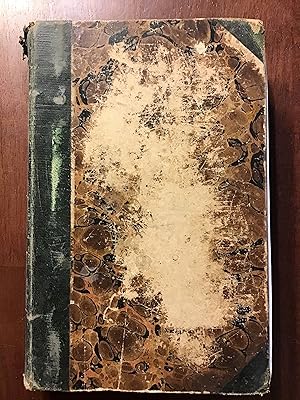
Hardcover. Condizione: Good. Marbled boards with green corners and gilt lettering on green spine. 572 pages. Chips to all extremities and spine ends. Bumps and rubs and soiling to cover. A few pencil notes on blank endpaper. Fold-out map in front has been removed. (Scans available upon request.) Size: 8vo - over 7¾" - 9¾" tall.
-

The British Empire showing the Great Commercial Highways. Map of the World on Mercator's Projection showing all countries of the British Empire
Lingua: Inglese
Editore: The Offices of the Amalgamated Press, London, 1907
Da: Kilrimund Books, Gateside, FIFE, Regno Unito
Valutazione del venditore 5 su 5 stelle
Mappa Prima edizione
EUR 23,85
Spedizione EUR 25,48
Spedito da Regno Unito a U.S.A.Quantità: 1 disponibili
Aggiungi al carrelloSoft cover. Condizione: Very Good. 1st Edition. Map extract from the Harmsworth Universal Atlas and Gazetteer (circa 1907). Single sheet (measuring 510 mm x 392 mm) with single fold as issued. Clean and crisp condition.
-

An Accompaniment to Mitchell's Map of the World: On Mercator's Projection; Containing an Index to the Various Countries, Cities, Towns, Islands, &c., ... Five Great Divisions of the Globe, America,
Da: Ria Christie Collections, Uxbridge, Regno Unito
Valutazione del venditore 5 su 5 stelle
EUR 40,87
Spedizione EUR 13,87
Spedito da Regno Unito a U.S.A.Quantità: Più di 20 disponibili
Aggiungi al carrelloCondizione: New. In.
-
An Accompaniment to Mitchell's Map of The World on Mercator's Projection
Editore: S. Augustus Mitchell, 1845
Da: Arader Galleries of Philadelphia, PA, Philadelphia, PA, U.S.A.
Valutazione del venditore 4 su 5 stelle

Hardcover. Condizione: Very Good. green decorated boards with green leather spine solid and tight.
-
The World - Mercator's Projection Map 1870
Lingua: Inglese
Editore: 1870, 1870
Da: Manning's Books & Prints, ABAA, Pacifica, CA, U.S.A.
Membro dell'associazione: ABAA ILAB
Valutazione del venditore 3 su 5 stelle

No Binding. Condizione: Fine. 25" X 15¼". Mitchell's New General Atlas Hand Colored Map From 1870. Published In Ny. Hand Colored Engraving.
-
The World on Mercator's Projection (map of)
Editore: London Printing and Publishing Company, London, 1860
Da: Victoria Bookshop, BERE ALSTON, DEVON, Regno Unito
Valutazione del venditore 4 su 5 stelle
EUR 30,30
Spedizione EUR 11,41
Spedito da Regno Unito a U.S.A.Quantità: 1 disponibili
Aggiungi al carrelloPaperback. Condizione: G-. First Thus. Minor creasing and a number of splits/1 long closed tear to tail edge. nick to RH side edge with small loss. this map has been folded. Very minor foxing. Decorative Black & White 19th century map for the Image Size: 350 x 245mm, 13.75 x 9.75" approx. Paper Size: 390 x 285mm, 15.25 x 11.25" approx. John Rapkin (fl. 1835-65) A nineteenth century map maker and engraver, best known for his work on the Illustrated Atlas of the World 1849-53 for John Tallis and Co. noted for their beautifully decorative borders and later re-issued by the London Printing and Publishing Co. London and New York. Book.
-

MAP: "Map of The World on Mercator's Projection" .from Standard Atlas of Outgamie County, Wisconsin
Editore: Geo. A. Ogle & Co., Chicago, 1917
Da: Dorley House Books, Inc., Hagerstown, MD, U.S.A.
Valutazione del venditore 4 su 5 stelle
Arte / Stampa / Poster Prima edizione
Unbound. Condizione: Very Good. Handcolored Map (illustratore). 1st. 17.5" x 28.5" handcolored map Size: 17.5" x 28.5".
-
MAP: THE WORLD ON MERCATORS PROJECTION.
Editore: Undated. George Philip & Son. London.
Da: Black Cat Bookshop P.B.F.A, Leicester, Regno Unito
Membro dell'associazione: PBFA
Valutazione del venditore 5 su 5 stelle
EUR 29,82
Spedizione EUR 17,58
Spedito da Regno Unito a U.S.A.Quantità: 1 disponibili
Aggiungi al carrelloCloth mounted map of the world, with principal steamer routes marked. Not dated, but shows The British Empire & Japanese Mandate. Also shows countries administered by The League of Nations. All neatly folded and contained in its orginal red linen backed folder. (Spine on folder a touch faded). Generally VG (minor wear to a couple of the folds). Nice & clean.
-

Map of the World - Mercator's Projection (1883 Original Antique Colour Print)
Editore: George W. Bacon, UK, 1883
Da: Maynard & Bradley, Leicester, Regno Unito
Valutazione del venditore 5 su 5 stelle
EUR 23,80
Spedizione EUR 25,42
Spedito da Regno Unito a U.S.A.Quantità: 1 disponibili
Aggiungi al carrelloSoftcover. Condizione: Very Good. 1883. A clean and well-presented colour map produced by Bacon in 1883. Central fold line, as originally presented, with some very small nicks at the outer edges repaired and reinforced with conservation tape to prevent wear. No other notable signs of wear. Why on Amazon do most sellers not describe their actual book? Buy with confidence and support a genuine Independent Bricks & Mortar Real Bookshop. We are Maynard & Bradley CAMBO & PBFA(now lapsed) members here in Leicester City Centre. Size: 350 x 505 mm. 1. Item Type: Book. Quantity Available: 1. Shipped Weight: Under 1 kilo. Category: Geography & Maps; Britain/UK; 19th century; Inventory No: 44318.
-
WORLD MAP Mercators Projection 1894 Colour Antique Map
Editore: Meyers Konversations
Da: Artisans-lane Maps & Prints, Sidney, BC, Canada
Valutazione del venditore 5 su 5 stelle
Arte / Stampa / Poster
EUR 16,02
Spedizione EUR 16,32
Spedito da Canada a U.S.A.Quantità: 1 disponibili
Aggiungi al carrellono binding. Condizione: very good. This is a historical world map from 1894, printed in color and using the Mercator projection. The map is in excellent condition, with clear and detailed details, and is a book plate map that has been folded. The text on the map is in German. The overall size of the map is approximately 12 inches by 9.5 inches, and the reverse side is blank.
-

c1912 THE WORLD MAP on Mercators Projection Barren Regions Developed areas (BS5)
Da: Antique Paper Company, ASHFORD, KENT, Regno Unito
Valutazione del venditore 3 su 5 stelle
EUR 17,89
Spedizione EUR 6,95
Spedito da Regno Unito a U.S.A.Quantità: 1 disponibili
Aggiungi al carrelloListing Template 2018 Home About Us View Feedback Contact Us c1912 THE WORLD MAP on Mercators Projection Barren Regions Developed areas (BS5)Click image to enlargeDescriptionc1912An original coloursmall antique maptaken from 'Handy Reference Atlas of the world' titled:THE WORLD on Mercators ProjectionOverall size of thismapis approx 22cm x 18cm with central fold as issued.Published by John Bartholomew Co, Edinburgh.Shipping View Our Categories Decorative Prints World Wide Maps Scotland Maps Architecture Design England Maps Royalty About UsWe specialise in selling all items that can be considered to be Antique Paper. * PRINTS * MAPS * HISTORICAL DOCUMENTS * POSTAL HISTORY * BOOKS * POSTERS * STAMPS * POSTCARDS * EPHEMERA And anything else that is considered Antique and made of Paper. ALL OF OUR ITEMS ARE ORIGINAL ANTIQUES - NOT MODERN COPIES. We are also very keen buyers of anything similar and especially after better collections, original archives, whole libraries and better single items and have and#163;250,000 in cash funds at anyone time to buy the right items. Contact UsIf you have any questions then please do not hesitate to contact us through the eBay messaging system. Feedback We will always help you to have a 100% positive happy buying experience. Contact us if you are unhappy about any aspect of your purchase from us. We only want five star feedback from you so buy with confidence.
-
An Accompaniment to Mitchell's Map of the World: On Mercator's Projection
Da: Forgotten Books, London, Regno Unito
Valutazione del venditore 4 su 5 stelle
EUR 23,17
Spedizione gratuita
Spedito da Regno Unito a U.S.A.Quantità: Più di 20 disponibili
Aggiungi al carrelloPaperback. Condizione: New. Print on Demand. This book is a comprehensive guide to the geographical and natural features of North America. Focused on presenting an overview of the continent's physical geography, the author discusses mountain ranges, river systems, lakes, plains, and animal life, detailing the geographic location of each and presenting scientific information in accessible language. The book places special emphasis on the unique characteristics of North America's geography and the interplay between the continent's physical features and its development, concluding with the significance of this interplay on the study of geography. This book is a reproduction of an important historical work, digitally reconstructed using state-of-the-art technology to preserve the original format. In rare cases, an imperfection in the original, such as a blemish or missing page, may be replicated in the book. print-on-demand item.
-
An Accompaniment To Mitchell's Map Of The World, On Mercator's Projection; Containing An Index To The Various Countries, Cities, Towns, Islands.
Lingua: Inglese
Editore: R.L. Barnes, Philadelphia, PA, 1839
Da: Shaker Mill Books, W. Stockbridge, MA, U.S.A.
Valutazione del venditore 5 su 5 stelle
Hardcover. Condizione: Good. Tight binding, leather spine strip over rubbed marbled boards, "Mitchell's World" in bright gilt lettering to spine strip chipped at spine ends, foxing throughout not affecting readability, otherwise unmarked.
-

An Accompaniment to Mitchell's Map of the World: On Mercator's Projection; Containing an Index to the Various Countries, Cities, Towns, Islands, &c.
Lingua: Inglese
Editore: Creative Media Partners, LLC Jul 2023, 2023
ISBN 10: 1021333735 ISBN 13: 9781021333735
Mappa
EUR 47,01
Spedizione EUR 64,02
Spedito da Germania a U.S.A.Quantità: 2 disponibili
Aggiungi al carrelloTaschenbuch. Condizione: Neu. Neuware - This guide to Mitchell's map of the world offers useful background information and a comprehensive index of the map's features. With detailed descriptions of the countries and regions represented, as well as a discussion of the different geographical regions of the world, this guide is an essential tool for anyone using Mitchell's world map.
-
EUR 12,71
Spedizione EUR 105,00
Spedito da Germania a U.S.A.Quantità: 1 disponibili
Aggiungi al carrelloCondizione: Sehr gut. Zustand: Sehr gut | Seiten: 578 | Sprache: Englisch | Produktart: Bücher | Keine Beschreibung verfügbar.
-

An Accompaniment to Mitchell's Map of the World: On Mercator's Projection; Containing an Index to the Various Countries, Cities, Towns, Islands, &c.
Lingua: Inglese
Editore: Creative Media Partners, LLC Aug 2024, 2024
ISBN 10: 1019636238 ISBN 13: 9781019636237
Mappa
EUR 60,15
Spedizione EUR 64,92
Spedito da Germania a U.S.A.Quantità: 2 disponibili
Aggiungi al carrelloBuch. Condizione: Neu. Neuware - This guide to Mitchell's map of the world offers useful background information and a comprehensive index of the map's features. With detailed descriptions of the countries and regions represented, as well as a discussion of the different geographical regions of the world, this guide is an essential tool for anyone using Mitchell's world map.
-

EUR 35,63
Spedizione EUR 105,00
Spedito da Germania a U.S.A.Quantità: 1 disponibili
Aggiungi al carrelloCondizione: Hervorragend. Zustand: Hervorragend | Seiten: 576 | Sprache: Englisch | Produktart: Bücher | Keine Beschreibung verfügbar.
-
COMMERCIAL & POLITICAL MAP OF THE WORLD on Mercator's Projection
Lingua: Inglese
Editore: Geographia Ltd, London, 1920
Da: THOMAS RARE BOOKS, Yaxley, SUFFOLK, Regno Unito
Valutazione del venditore 4 su 5 stelle
Prima edizione
EUR 417,46
Spedizione EUR 17,37
Spedito da Regno Unito a U.S.A.Quantità: 1 disponibili
Aggiungi al carrellopaperback. Condizione: Fine. 1st Edition. FOLDING MAP: Lithographic colour map MOUNTED ON LINEN c1920 measuring 1460x950 mm (37.5 x 57.25 inches). A fine copy of a scarce map. Green board covers, gilt, [spine worn but complete]. A very attractive map of the world and British Empire just after the first world war.
-
World Map Mercator's Projection Oceans southern continent 1886 Flemming map
Data di pubblicazione: 1886
Da: RareMapsandBooks, Dover, NH, U.S.A.
Membro dell'associazione: ESA IOBA
Valutazione del venditore 4 su 5 stelle
Mappa
Condizione: good. Erdkarte in Mercator's Projection.(Old Maps, 19th Century Maps, World Map, Mercator's Projection, Ocean Currents, North & South America, Africa, Europe, Asia, Oceania). Issued 1886, Glogau by Flemming. Mid 19th century color lithographed map. Of interest for the numerous place names assigned along the Antarctic coastline across the bottom. Also shows the basic flow patterns of ocean currents. Nice looking example, pleasing age patina, any minor age flaws easy to overlook or forgive. Original center fold as issued. Sheet Measures c. 15 1/2" H x 18" W. Engraved Area Measures c. 13" H x 13" W. Cartographic Reference (s):Tooley'sà Dictionary of Mapmakers, vol 2.[R28179].
-

MAP: "Johnson's Map of the World on Mercator's Projection'.from Johnson's New Illustrated (Steel Plate) Family Atlas, 1861
Editore: Johnson & Browning, Richmond, VA, 1861
Da: Dorley House Books, Inc., Hagerstown, MD, U.S.A.
Valutazione del venditore 4 su 5 stelle
Arte / Stampa / Poster Prima edizione
Unbound. Condizione: Very Good. Handcolored (illustratore). 1st. Plate #6,7: lovely double page map of the mid 19th century world, including major sea routes of explorers (Captain Cook, captain Wilkes); comparative distances, etc. Priced here to reflect the repaired closed tear at the lower edge. Size: 17 x 24.5 Inches.
-

Colton's Map of the World, on Mercator's Projection
Lingua: Inglese
Editore: Colton, New York, 1864
Da: Anah Dunsheath RareBooks ABA ANZAAB ILAB, Auckland, NZ, Nuova Zelanda
Membro dell'associazione: ABA ANZAAB ILAB
Valutazione del venditore 5 su 5 stelle
Mappa
EUR 83,13
Spedizione EUR 21,47
Spedito da Nuova Zelanda a U.S.A.Quantità: 1 disponibili
Aggiungi al carrelloNo Binding. Condizione: Good. An attractive coloured map of the world decorated with ships, compass, and routes of various voyagers such as Vancouver, Cook etc. 52 x 73 cm folding into a neat small cloth cover. Some repair to folds. A most attractive map with a highly decorative surround.
-
World Map Mercator's Projection Sea Lanes Shipping Routes 1882 Blackie map
Data di pubblicazione: 1882
Da: RareMapsandBooks, Dover, NH, U.S.A.
Membro dell'associazione: ESA IOBA
Valutazione del venditore 5 su 5 stelle
Mappa
Condizione: good. The World on Mercator's Projection Showing the Course of the Chief Ocean Currents and the Navigation Tracks Between the Principal Ports.(World Map, Mercator's Projection, North America, South America, Asia, Oceania, Africa, Europe, Sea Lanes, Shipping Routes). Issued 1882, Edinburgh by Blackie & Son. Very detailed late 19th century color lithographed map. Well preserved, nice looking example with pleasing age patina. 3" closed split at bottom of centerfold. Original center fold as issued. Sheet Measures c. 15" H x 22" W. Engraved Area Measures c. 13 1/2" H x 19 3/4" W. Cartographic Reference (s):Tooley'sà Dictionary of Mapmakers, vol. 1.[R23164].
-
World Chart of Magnetic Curves 1844 Mercator's Projection A&C Black map
Data di pubblicazione: 1844
Da: RareMapsandBooks, Dover, NH, U.S.A.
Membro dell'associazione: ESA IOBA
Valutazione del venditore 5 su 5 stelle
Mappa
Condizione: good. A Chart of Magnetic Curves of Equal Variation by Peter Barlow.(Old Maps, 19th Century Maps, World Maps, North America, South America, Africa, Europe, Asia, Oceania). Issued 1844, Edinburgh by A. & C. Black. Map by Aikman. Mid 19th century lithographed map. Well preserved, nice looking example with pleasing age patina. Sheet Measures c. 12 1/4" H x 16 3/4" W. Printed Area Measures c. 10 1/4" H x 14 3/4" W. Cartographic Reference (s):Tooley'sà Dictionary of Mapmakers, vol. 1.[R30841].