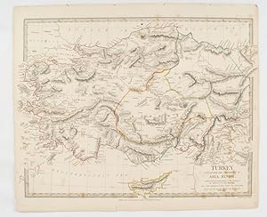
C walker engravers (21 risultati)

Lingua: Inglese
Editore: Samuel Lewis, London 1837
- Mappa
Da: Philip Gibbons Books, Newcastle Emlyn, Regno UnitoPhilip Gibbons Books
Contatta il venditoreVenditore con 5 stelleCondizione: Usato - Molto buono
EUR 11,81
EUR 41,48 spedizioneSpedito da Regno Unito a U.S.A.Quantità: 1 disponibili
No binding. Condizione: Very Good. Antiquarian map: image (plate size): 18cm wide by 24 cm high; sheet size: 21cm by 29cm, steel engraving with original outline hand-colouring. Very Good, unmarked. Originally from Lewis's "Topographical Dictionary". Pictures show this actual map. UK orders are post-free. Sent flat in a card-back…ed envelope.

Editore: Edward Stanford 1844
- Rilegato
Da: Anybook.com, Lincoln, Regno UnitoAnybook.com
Contatta il venditoreVenditore con 5 stelleCondizione: Usato - Discreto
EUR 59,34
EUR 15,67 spedizioneSpedito da Regno Unito a U.S.A.Quantità: 1 disponibili
Condizione: Fair. This is ex-library and may have the usual library/used-book markings inside. In fair condition, suitable as a study copy. Likely dated 1844. Monochrome. Approx 30 x 43.5cm. Scale in Spanish Leagues 26.2 -One Degree. And English miles 68.75 One degree. Map has been neatly cut into 9 equal sections and backed ont…o cloth so it may be folded easily. Some general grubbiness. There are approx. twenty small red pen underlinings of place names on map. A couple of corners are slighty worn. On reverse side of two panels blue board has been secured, and labelled with black writing within a white sticker. Small pencil marking on back of map which is also grubby. Please note the Image in this listing is a stock photo and may not match the covers of the actual item,100grams, ISBN.

Editore: Society for the Diffusion of Useful Knowledge; Baldwin & Cradock., London. 1832
Da: Asia Bookroom ANZAAB/ILAB, Canberra, ACT, AustraliaAsia Bookroom ANZAAB/ILAB
Contatta il venditoreVenditore con 5 stelleCondizione: Usato
EUR 47,19
EUR 18,54 spedizioneSpedito da Australia a U.S.A.Quantità: 1 disponibili
Handcoloured map, 28.5 x 39 cms (including platemark); 34 x 41 cms (sheet), relief throughout shown by hachures, publisher's or binder's numeric stamp (102), the margins a little browned and chipped, but in very good condition. This sheet maps a sweeping, wild, and politically fragmented area of North-Eastern and Central-Eastern… India. It captures the dense, rugged interiors of Allahabad, Bahar (Bihar), Gangpoor, Sumbhulpoor, and Ruttunpoor. The sheet explicitly delineates the territories under direct East India Company British administration from those of the sovereign regional native rulers, specifically marking out the lands of the Rajah of Berar, the Rajah of Rewah, and the Bundelcund (Bundelkhand). The maritime port city of Balasore sits near the lower right-hand margin where the land meets the Bay of Bengal.

Editore: Charles Knight & Co. for the Society of the Diffusion of Useful Knowledge 1848
- Rilegato
Da: Francis Edwards ABA ILAB, Hay on Wye, , Regno UnitoFrancis Edwards ABA ILAB
Contatta il venditoreVenditore con 5 stelleCondizione: Usato
EUR 78,33
EUR 21,89 spedizioneSpedito da Regno Unito a U.S.A.Quantità: 1 disponibili
Corrected Ed. 31 x 37 inches. Linen backed folding map hand coloured in outline, dec. e.ps., folding into gilt lettered textured brown cloth boards, some scratching and sl. bubbling, rebacked in black cloth. With the signature of Flo. Fitzwygram Cap. Inniskilling Dragoons 1853. Lieutenant-General Sir Frederick Wellington John Fi…tzwygram, 4th Baronet DL JP (18231904) British Army cavalry officer, expert on horses and Conservative politician. A cavalry officer who served with the 6th (Inniskilling) Dragoons in the Crimean War. He subsequently commanded the Cavalry Brigade at Aldershot. US$89.

Editore: Society for the Diffusion of Useful Knowledge; Baldwin & Cradock., London. 1832
Da: Asia Bookroom ANZAAB/ILAB, Canberra, ACT, AustraliaAsia Bookroom ANZAAB/ILAB
Contatta il venditoreVenditore con 5 stelleCondizione: Usato
EUR 59,77
EUR 18,54 spedizioneSpedito da Australia a U.S.A.Quantità: 1 disponibili
Handcoloured map, 29.5 x 39 cms (including platemark); 34.5 x 42 cms (sheet), relief throughout shown by hachures, publisher's or binder's stamp (99), the margins a little browned and chipped, but in very good condition. An attractive map showing Central and Eastern India, including Hyderabad, Berear and the Northern Circars. Th…is long coastal strip along the Bay of Bengal (modern-day Andhra Pradesh and Odisha) is marked as a critical British presidency asset. The map shows its major maritime ports, like Masulipatnam and Visakhapatnam, which acted as vital economic gatekeepers connecting Central India's interior to ocean trade lines. As the official hydrographers to the East India Company, John and Charles Walker packed their maps with technical markers intended to educate the British public.

Editore: (Society for the Diffusion of Useful Knowledge); Charles Knight, London. 1852
Da: Asia Bookroom ANZAAB/ILAB, Canberra, ACT, AustraliaAsia Bookroom ANZAAB/ILAB
Contatta il venditoreVenditore con 5 stelleCondizione: Usato
EUR 78,65
EUR 18,54 spedizioneSpedito da Australia a U.S.A.Quantità: 1 disponibili
Engraved map, 39 x 30.5 cms; 41 x 34 cms (sheet), relief throughout shown by hachures, publisher's or binder's numeric stamp (94A), the margins a little browned and chipped with loss to the two keys at the inner edge marking Indian and Persian distances but the map in very good condition. A highly detailed example of political a…nd military cartography from the height of the Victorian era, capturing the Central Asian frontier at the dawn of the "Great Game". The map covers the expanse of Central Asia, stretching from the deserts of modern-day Uzbekistan and Turkmenistan down through Afghanistan and Pakistan to the Arabian Sea. It maps out the Emirate of Bukhara in the north and the Desert of Khiva. It explicitly references the "Nomadic Tribes of Turkomans" roaming the steppes. Afghanistan is centred on the map, and displays the fractured geography of the Afghan kingdom. It details the treacherous mountain passes of the Hindu Kush, alongside the major strategic cities of Kabul, Kandahar, and Herat. Beloochistan (Balochistan) & Sinde (Sindh)anchor the southern third of the sheet, it routes down toward the coastline, showing the vast desert paths, tribal domains, and the mouth of the Indus River.
Editore: Society for the Diffusion of Useful Knowledge. Baldwin & Cradock., London. 1830
Da: Asia Bookroom ANZAAB/ILAB, Canberra, ACT, AustraliaAsia Bookroom ANZAAB/ILAB
Contatta il venditoreVenditore con 5 stelleCondizione: Usato
EUR 78,65
EUR 18,54 spedizioneSpedito da Australia a U.S.A.Quantità: 1 disponibili
Engraved map wth outline hand colour, 29.7 x 42 cm, relief shown in hachures, key to abbreviations, including "Ancient Ruins", the west and east extremities attactively engraved to burst through the border, original folds, map with occasional spotting, more pronounced at the lower corner, edges a little ragged, small chip to the… inner margin (no loss to the map), manuscript pagination in the lower corner, but in good condition.

Editore: LondonThe Admiralty. 1921
- Mappa
Da: Robert Frew Ltd. ABA ILAB, London, , Regno UnitoRobert Frew Ltd. ABA ILAB
Contatta il venditoreVenditore con 5 stelleCondizione: Usato
EUR 118,68
EUR 11,52 spedizioneSpedito da Regno Unito a U.S.A.Quantità: 1 disponibili
63.5 x 111.5 cm. Uncoloured, with principal points (light houses, etc) highighted in orange. Large folding sheet chart of the Firth of Forth. Title in red ink on verso. Some offsetting. Ink stamp to lower right corner.
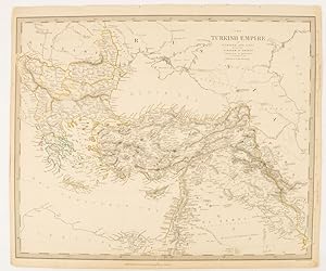
The Turkish Empire in Europe and Asia with the Kingdom of Greece.
SOCIETY FOR THE DIFFUSION OF USEFUL KNOWLEDGE (SDUK), J & C WALKER (ENGRAVERS)
Editore: Charles Knight & Co. [circa1840s.], London. 1840
Da: Asia Bookroom ANZAAB/ILAB, Canberra, ACT, AustraliaAsia Bookroom ANZAAB/ILAB
Contatta il venditoreVenditore con 5 stelleCondizione: Usato
EUR 141,57
EUR 18,54 spedizioneSpedito da Australia a U.S.A.Quantità: 1 disponibili
Lithographed map with original outline hand-colour, 31.9 x 39.1 cm, small marginal tears neatly repaired with archival material, but no loss, small surface abrasion affecting the border at the foot, edgewear and browning, inked pagination in an early hand, but in very good condition. A handsome map with fine topographical engrav…ing, also showing the borders with Hungary, Russia and Persia.

Editore: Society for the Diffusion of Useful Knowledge, London. 1839
Da: Asia Bookroom ANZAAB/ILAB, Canberra, ACT, AustraliaAsia Bookroom ANZAAB/ILAB
Contatta il venditoreVenditore con 5 stelleCondizione: Usato
EUR 220,22
EUR 18,54 spedizioneSpedito da Australia a U.S.A.Quantità: 1 disponibili
A pair of engraved maps, 39.1 x 41.6 cms, 41.1 x 34.5 cms (sheet), sealed edge tears to the right outer margins on each sheet (without loss), the left margins have been re-enforced with washi, some age-toning, but both maps in very good condition. Highly detailed regional maps of the Northwest Frontier. Map 107 details the Five…Rivers of the Punjab, Sindh, and Kashmir and Map 107 A is specialized supplemental sheet, broadening the scope to map out the rugged mountain passes, military routes, and tribal territories of Afghanistan stretching toward Kabul and Kandahar, part of a regional survey published by SDUK. Strategically important maps published at the outbreak of the First Anglo-Afghan War and in the wake of regional border struggles marking the Great Game.

The River Euphrates from Abu' Saide to Werdi.From The Expedition for the Survey of the Euphrates and Tigris, 1836-1840. First edition of the map.
Chesney, Francis Rawdon, (1789-1872);Commander H. Blosse Lynch (1807-1873); J. & C. Walker, engravers
Editore: [London]: Colonel Chesney 1849
- Stampa artistica
Da: Wittenborn Art Books, San Francisco, CA, U.S.A.Wittenborn Art Books
Contatta il venditoreVenditore con 4 stelleCondizione: Usato - Buono
EUR 673,96
EUR 8,72 spedizioneSpedito in U.S.A.Quantità: 1 disponibili
Condizione: Good. Original engraving. Map IV of XII. 50 x 62 x cm. Folding. Marginal tears.The 12 maps were printed separately by the firm of J. & C. Walker, who was the official printer for the British Admiralty and the East India Company. They were published by Colonel Chesney himself in 1849. They were more commonly issued al…ong with Chesney's text volumes, "The Expedition for The Survey of The Rivers Euphrates and Tigris, Carried on by Order of The British Gov. , "published by Longman, Brown, Green, and Longmans, London, 1850.OCLC Number / Unique Identifier:316378697 for the complete set.The Euphrates expedition of 1836 was lead by the British army officer Colonel Francis Rawson Chesney. The main objective was to establish a route "between the Mediterranean Sea and His Majesty's possessions in the East Indies by means of a steam communication of the river Euphrates". Finding a shorter route to India was the hot topic of the time. The East India Company sought a suitable solution to cut down the travel time between England and India. Chesney was involved in initial surveys in Egypt and the Middle East in the late 1820s where he investigated the possibility of passage to India via the Red Sea. In 1829 he submitted a report advocating the construction of the Suez Canal. He also brought to attention the feasibility of steam communication with India through the Euphrates. The king William IV himself expressed a desire that the route by the Euphrates to India should be put to a practical test.In late 1834 when Chesney received funds for the expedition he assembled a capable group of naval and military officers including the explorer Henry Blosse Lynch of the Indian Navy and a geologist William Francis Ainsworth, president of the Royal Physical Society of Edinburgh. He also selected workmen from the Royal Artillery, Royal Sappers and Miners qualified in steam machinery, surveying and drawing. Chesney returned to England in September 1832 after surveying the lower Euphrates by raft and was convinced that the river was navigable, providing a swift route to India. He also believed a British presence in Mesopotamia would discourage Russian encroachment. Chesney had a well-publicised interview with William IV in April 1833, who became an avid supporter of the Euphrates scheme. Petitioning led to the nomination of a select committee which in June 1834 supported an exploratory expedition with the backing of £20,000. Chesney was given the temporary rank of Colonel and lead fourteen officers and thirty-nine men on the mission.On 10th February 1835 they sailed for Syria. The two steamships, 'Euphrates' and 'Tigris', had to be tugged in sections over fifty miles of difficult terrain, the Arab tribes along the route were hostile and many of the men, including Chesney, suffered from malaria. On 21st May 1836 a sudden storm hit and the 'Tigris' was wrecked with the loss of twenty lives. . Chesney managed, with the remaining boat, to explore and chart the Euphrates, the Tigris and the Karum rivers. This exploration ended in India and he returned to London in August 1837. This accomplishment won him the admiration of geographers and he was awarded the Geographical Society's gold medal. .After preparing an account of the expedition, Chesney returned to regimental duty in 1841 and by 1843 had risen in rank being appointed Commandant of Hong Kong. In 1847 Chesney returned to England; his last military appointment was as Colonel Commandant of the Cork district, after which he retired to his home at Pacolet, near Kilkeel, county Down, Ireland in 1852.Expertise by Elvire POULAIN &Anne Sophie JONCOUX-PILORGE, Paris.

The River Tigris from Nineveh to Kalah Sherakat and from Kalah Sherakat to Samarra. From The Expedition for the Survey of the Euphrates and Tigris, 1836-1840. First edition of the map.
Chesney, Francis Rawdon, (1789-1872);Commander H. Blosse Lynch (1807-1873); J. & C. Walker, engravers
Editore: [London]: Colonel Chesney 1849
- Stampa artistica
Da: Wittenborn Art Books, San Francisco, CA, U.S.A.Wittenborn Art Books
Contatta il venditoreVenditore con 4 stelleCondizione: Usato - Buono
EUR 673,96
EUR 8,72 spedizioneSpedito in U.S.A.Quantità: 1 disponibili
Condizione: Good. Original engraving. Map VI of XII. 61x 50cm. Folding Marginal tears.The 12 maps were printed separately by the firm of J. & C. Walker, who was the official printer for the British Admiralty and the East India Company. They were published by Colonel Chesney himself in 1849. They were more commonly issued along w…ith Chesney's text volumes, "The Expedition for The Survey of The Rivers Euphrates and Tigris, Carried on by Order of The British Gov." published by ongman, Brown, Green, and Longmans, London, 1850.OCLC Number / Unique Identifier:316378697 for the complete set.The Euphrates expedition of 1836 was lead by the British army officer Colonel Francis Rawson Chesney. The main objective was to establish a route "between the Mediterranean Sea and His Majesty's possessions in the East Indies by means of a steam communication of the river Euphrates". Finding a shorter route to India was the hot topic of the time. The East India Company sought a suitable solution to cut down the travel time between England and India. Chesney was involved in initial surveys in Egypt and the Middle East in the late 1820s where he investigated the possibility of passage to India via the Red Sea. In 1829 he submitted a report advocating the construction of the Suez Canal. He also brought to attention the feasibility of steam communication with India through the Euphrates. The king William IV himself expressed a desire that the route by the Euphrates to India should be put to a practical test. In late 1834 when Chesney received funds for the expedition he assembled a capable group of naval and military officers including the explorer Henry Blosse Lynch of the Indian Navy and a geologist William Francis Ainsworth, president of the Royal Physical Society of Edinburgh. He also selected workmen from the Royal Artillery, Royal Sappers and Miners qualified in steam machinery, surveying and drawing. Chesney returned to England in September 1832 after surveying the lower Euphrates by raft and was convinced that the river was navigable, providing a swift route to India. He also believed a British presence in Mesopotamia would discourage Russian encroachment. Chesney had a well-publicised interview with William IV in April 1833, who became an avid supporter of the Euphrates scheme. Petitioning led to the nomination of a select committee which in June 1834 supported an exploratory expedition with the backing of £20,000. Chesney was given the temporary rank of Colonel and lead fourteen officers and thirty-nine men on the mission.On 10th February 1835 they sailed for Syria. The two steamships, 'Euphrates' and 'Tigris', had to be tugged in sections over fifty miles of difficult terrain, the Arab tribes along the route were hostile and many of the men, including Chesney, suffered from malaria. On 21st May 1836 a sudden storm hit and the 'Tigris' was wrecked with the loss of twenty lives. Chesney managed, with the remaining boat, to explore and chart the Euphrates, the Tigris and the Karum rivers. This exploration ended in India and he returned to London in August 1837. This accomplishment won him the admiration of geographers and he was awarded the Geographical Society's gold medal. .After preparing an account of the expedition, Chesney returned to regimental duty in 1841 and by 1843 had risen in rank being appointed Commandant of Hong Kong. In 1847 Chesney returned to England; his last military appointment was as Colonel Commandant of the Cork district, after which he retired to his home at Pacolet, near Kilkeel, county Down, Ireland in 1852.Expertise by Elvire POULAIN &Anne Sophie JONCOUX-PILORGE, Paris.

The River Euphrates from Ummu-L-Huntah to Ku'rnah with the River Tigris from Serut Castle to Kurnah and the Shatt el 'Arabfrom Kurnah Basrah. From The Expedition for the Survey of the Euphrates and Tigris, 1836-1840. First edition of the map.
Chesney, Francis Rawdon, (1789-1872);Commander H. Blosse Lynch (1807-1873); J. & C. Walker, engravers
Editore: [London]: Colonel Chesney 1849
- Stampa artistica
Da: Wittenborn Art Books, San Francisco, CA, U.S.A.Wittenborn Art Books
Contatta il venditoreVenditore con 4 stelleCondizione: Usato - Buono
EUR 673,96
EUR 8,72 spedizioneSpedito in U.S.A.Quantità: 1 disponibili
Condizione: Good. Original engraving. Map X of XII. 77 x 49.5cm. Folding. Marginal tears and stains in top margin.The 12 maps were printed separately by the firm of J. & C. Walker, who was the official printer for the British Admiralty and the East India Company . They were published by Colonel Chesney himself in 1849. They were… more commonly issued along with Chesney's text volumes, "The Expedition for The Survey of The Rivers Euphrates and Tigris, Carried on by Order of The British Gov." published by ongman, Brown, Green, and Longmans, London, 1850.OCLC Number / Unique Identifier:316378697 for the complete set.The Euphrates expedition of 1836 was lead by the British army officer Colonel Francis Rawson Chesney. The main objective was to establish a route "between the Mediterranean Sea and His Majesty's possessions in the East Indies by means of a steam communication of the river Euphrates". Finding a shorter route to India was the hot topic of the time. The East India Company sought a suitable solution to cut down the travel time between England and India. Chesney was involved in initial surveys in Egypt and the Middle East in the late 1820s where he investigated the possibility of passage to India via the Red Sea. In 1829 he submitted a report advocating the construction of the Suez Canal. He also brought to attention the feasibility of steam communication with India through the Euphrates. The king William IV himself expressed a desire that the route by the Euphrates to India should be put to a practical test. In late 1834 when Chesney received funds for the expedition he assembled a capable group of naval and military officers including the explorer Henry Blosse Lynch of the Indian Navy and a geologist William Francis Ainsworth, president of the Royal Physical Society of Edinburgh. He also selected workmen from the Royal Artillery, Royal Sappers and Miners qualified in steam machinery, surveying and drawing. Chesney returned to England in September 1832 after surveying the lower Euphrates by raft and was convinced that the river was navigable, providing a swift route to India. He also believed a British presence in Mesopotamia would discourage Russian encroachment. Chesney had a well-publicised interview with William IV in April 1833, who became an avid supporter of the Euphrates scheme. Petitioning led to the nomination of a select committee which in June 1834 supported an exploratory expedition with the backing of £20,000. Chesney was given the temporary rank of Colonel and lead fourteen officers and thirty-nine men on the mission.On 10th February 1835 they sailed for Syria. The two steamships, 'Euphrates' and 'Tigris', had to be tugged in sections over fifty miles of difficult terrain, the Arab tribes along the route were hostile and many of the men, including Chesney, suffered from malaria. On 21st May 1836 a sudden storm hit and the 'Tigris' was wrecked with the loss of twenty lives. Chesney managed, with the remaining boat, to explore and chart the Euphrates, the Tigris and the Karum rivers. This exploration ended in India and he returned to London in August 1837. This accomplishment won him the admiration of geographers and he was awarded the Geographical Society's gold medal. .After preparing an account of the expedition, Chesney returned to regimental duty in 1841 and by 1843 had risen in rank being appointed Commandant of Hong Kong. In 1847 Chesney returned to England; his last military appointment was as Colonel Commandant of the Cork district, after which he retired to his home at Pacolet, near Kilkeel, county Down, Ireland in 1852.Expertise by Elvire POULAIN &Anne Sophie JONCOUX-PILORGE, Paris.

The River Euphrates from Hit to the Kuthah River and the River Tigris from Samarra to the Abu Hitti Canal from Samarra toDokhala and from Dokhala to the Abu Hitti Canal. From The Expedition for the Survey of the Euphrates and Tigris, 1836-1840. First edition of the map.
Chesney, Francis Rawdon, (1789-1872);Commander H. Blosse Lynch (1807-1873); J. & C. Walker, engravers
Editore: [London]: Colonel Chesney 1849
- Stampa artistica
Da: Wittenborn Art Books, San Francisco, CA, U.S.A.Wittenborn Art Books
Contatta il venditoreVenditore con 4 stelleCondizione: Usato - Buono
EUR 673,96
EUR 8,72 spedizioneSpedito in U.S.A.Quantità: 1 disponibili
Condizione: Good. Original engraving. Map VII of XII. 50 x 62.5cm. Folding. Marginal tears.The 12 maps were printed separately by the firm of J. & C. Walker, who was the official printer for the British Admiralty and the East India Company . They were published by Colonel Chesney himself in 1849. They were more commonly issued a…long with Chesney's text volumes, "The Expedition for The Survey of The Rivers Euphrates and Tigris, Carried on by Order of The British Gov." published by ongman, Brown, Green, and Longmans, London, 1850.OCLC Number / Unique Identifier:316378697 for the complete set.The Euphrates expedition of 1836 was lead by the British army officer Colonel Francis Rawson Chesney. The main objective was to establish a route "between the Mediterranean Sea and His Majesty's possessions in the East Indies by means of a steam communication of the river Euphrates". Finding a shorter route to India was the hot topic of the time. The East India Company sought a suitable solution to cut down the travel time between England and India. Chesney was involved in initial surveys in Egypt and the Middle East in the late 1820s where he investigated the possibility of passage to India via the Red Sea. In 1829 he submitted a report advocating the construction of the Suez Canal. He also brought to attention the feasibility of steam communication with India through the Euphrates. The king William IV himself expressed a desire that the route by the Euphrates to India should be put to a practical test. In late 1834 when Chesney received funds for the expedition he assembled a capable group of naval and military officers including the explorer Henry Blosse Lynch of the Indian Navy and a geologist William Francis Ainsworth, president of the Royal Physical Society of Edinburgh. He also selected workmen from the Royal Artillery, Royal Sappers and Miners qualified in steam machinery, surveying and drawing. Chesney returned to England in September 1832 after surveying the lower Euphrates by raft and was convinced that the river was navigable, providing a swift route to India. He also believed a British presence in Mesopotamia would discourage Russian encroachment. Chesney had a well-publicised interview with William IV in April 1833, who became an avid supporter of the Euphrates scheme. Petitioning led to the nomination of a select committee which in June 1834 supported an exploratory expedition with the backing of £20,000. Chesney was given the temporary rank of Colonel and lead fourteen officers and thirty-nine men on the mission.On 10th February 1835 they sailed for Syria. The two steamships, 'Euphrates' and 'Tigris', had to be tugged in sections over fifty miles of difficult terrain, the Arab tribes along the route were hostile and many of the men, including Chesney, suffered from malaria. On 21st May 1836 a sudden storm hit and the 'Tigris' was wrecked with the loss of twenty lives. Chesney managed, with the remaining boat, to explore and chart the Euphrates, the Tigris and the Karum rivers. This exploration ended in India and he returned to London in August 1837. This accomplishment won him the admiration of geographers and he was awarded the Geographical Society's gold medal. .After preparing an account of the expedition, Chesney returned to regimental duty in 1841 and by 1843 had risen in rank being appointed Commandant of Hong Kong. In 1847 Chesney returned to England; his last military appointment was as Colonel Commandant of the Cork district, after which he retired to his home at Pacolet, near Kilkeel, county Down, Ireland in 1852.Expertise by Elvire POULAIN &Anne Sophie JONCOUX-PILORGE, Paris.

The River Euphrates from Werdi to Hit. From The Expedition for the Survey of the Euphrates and Tigris, 1836-1840. First edition of the map.
Chesney, Francis Rawdon, (1789-1872);Commander H. Blosse Lynch (1807-1873); J. & C. Walker, engravers
Editore: [London]: Colonel Chesney 1849
- Stampa artistica
Da: Wittenborn Art Books, San Francisco, CA, U.S.A.Wittenborn Art Books
Contatta il venditoreVenditore con 4 stelleCondizione: Usato - Buono
EUR 673,96
EUR 8,72 spedizioneSpedito in U.S.A.Quantità: 1 disponibili
Condizione: Good. Original engraving. Map V of XII. 50.5 x 60cm. Folding. Marginal tears.The 12 maps were printed separately by the firm of J. & C. Walker, who was the official printer for the British Admiralty and the East India Company. They were published by Colonel Chesney himself in 1849. They were more commonly issued alon…g with Chesney's text volumes, "The Expedition for The Survey of The Rivers Euphrates and Tigris, Carried on by Order of The British Gov." published by ongman, Brown, Green, and Longmans, London, 1850.OCLC Number / Unique Identifier:316378697 for the complete set.The Euphrates expedition of 1836 was lead by the British army officer Colonel Francis Rawson Chesney. The main objective was to establish a route "between the Mediterranean Sea and His Majesty's possessions in the East Indies by means of a steam communication of the river Euphrates". Finding a shorter route to India was the hot topic of the time. The East India Company sought a suitable solution to cut down the travel time between England and India. Chesney was involved in initial surveys in Egypt and the Middle East in the late 1820s where he investigated the possibility of passage to India via the Red Sea. In 1829 he submitted a report advocating the construction of the Suez Canal. He also brought to attention the feasibility of steam communication with India through the Euphrates. The king William IV himself expressed a desire that the route by the Euphrates to India should be put to a practical test. In late 1834 when Chesney received funds for the expedition he assembled a capable group of naval and military officers including the explorer Henry Blosse Lynch of the Indian Navy and a geologist William Francis Ainsworth, president of the Royal Physical Society of Edinburgh. He also selected workmen from the Royal Artillery, Royal Sappers and Miners qualified in steam machinery, surveying and drawing. Chesney returned to England in September 1832 after surveying the lower Euphrates by raft and was convinced that the river was navigable, providing a swift route to India. He also believed a British presence in Mesopotamia would discourage Russian encroachment. Chesney had a well-publicised interview with William IV in April 1833, who became an avid supporter of the Euphrates scheme. Petitioning led to the nomination of a select committee which in June 1834 supported an exploratory expedition with the backing of £20,000. Chesney was given the temporary rank of Colonel and lead fourteen officers and thirty-nine men on the mission.On 10th February 1835 they sailed for Syria. The two steamships, 'Euphrates' and 'Tigris', had to be tugged in sections over fifty miles of difficult terrain, the Arab tribes along the route were hostile and many of the men, including Chesney, suffered from malaria. On 21st May 1836 a sudden storm hit and the 'Tigris' was wrecked with the loss of twenty lives. Chesney managed, with the remaining boat, to explore and chart the Euphrates, the Tigris and the Karum rivers. This exploration ended in India and he returned to London in August 1837. This accomplishment won him the admiration of geographers and he was awarded the Geographical Society's gold medal. .After preparing an account of the expedition, Chesney returned to regimental duty in 1841 and by 1843 had risen in rank being appointed Commandant of Hong Kong. In 1847 Chesney returned to England; his last military appointment was as Colonel Commandant of the Cork district, after which he retired to his home at Pacolet, near Kilkeel, county Down, Ireland in 1852.Expertise by Elvire POULAIN &Anne Sophie JONCOUX-PILORGE, Paris.

The River Euphrates from Kal 'At En Nejm to Abu' Saide. From The Expedition for the Survey of the Euphrates and Tigris, 1836-1840. First edition of the map.
Chesney, Francis Rawdon, (1789-1872);Commander H. Blosse Lynch (1807-1873); J. & C. Walker, engravers
Editore: [London]: Colonel Chesney 1849
- Stampa artistica
Da: Wittenborn Art Books, San Francisco, CA, U.S.A.Wittenborn Art Books
Contatta il venditoreVenditore con 4 stelleCondizione: Usato - Buono
EUR 673,96
EUR 8,72 spedizioneSpedito in U.S.A.Quantità: 1 disponibili
Condizione: Good. Original engraving. Map III of XII. 50 x 62cm. Marginal tears.The 12 maps were printed separately by the firm of J. & C. Walker, who was the official printer for the British Admiralty and the East India Company . They were published by Colonel Chesney himself in 1849. They were more commonly issued along with C…hesney's text volumes, "The Expedition for The Survey of The Rivers Euphrates and Tigris, Carried on by Order of The British Gov." published by ongman, Brown, Green, and Longmans, London, 1850.OCLC Number / Unique Identifier:316378697.The Euphrates expedition of 1836 was lead by the British army officer Colonel Francis Rawson Chesney. The main objective was to establish a route "between the Mediterranean Sea and His Majesty's possessions in the East Indies by means of a steam communication of the river Euphrates". Finding a shorter route to India was the hot topic of the time. The East India Company sought a suitable solution to cut down the travel time between England and India. Chesney was involved in initial surveys in Egypt and the Middle East in the late 1820s where he investigated the possibility of passage to India via the Red Sea. In 1829 he submitted a report advocating the construction of the Suez Canal. He also brought to attention the feasibility of steam communication with India through the Euphrates. The king William IV himself expressed a desire that the route by the Euphrates to India should be put to a practical test.In late 1834 when Chesney received funds for the expedition he assembled a capable group of naval and military officers including the explorer Henry Blosse Lynch of the Indian Navy and a geologist William Francis Ainsworth, president of the Royal Physical Society of Edinburgh. He also selected workmen from the Royal Artillery, Royal Sappers and Miners qualified in steam machinery, surveying and drawing. Chesney returned to England in September 1832 after surveying the lower Euphrates by raft and was convinced that the river was navigable, providing a swift route to India. He also believed a British presence in Mesopotamia would discourage Russian encroachment. Chesney had a well-publicised interview with William IV in April 1833, who became an avid supporter of the Euphrates scheme. Petitioning led to the nomination of a select committee which in June 1834 supported an exploratory expedition with the backing of £20,000. Chesney was given the temporary rank of Colonel and lead fourteen officers and thirty-nine men on the mission.On 10th February 1835 they sailed for Syria. The two steamships, 'Euphrates' and 'Tigris', had to be tugged in sections over fifty miles of difficult terrain, the Arab tribes along the route were hostile and many of the men, including Chesney, suffered from malaria. On 21st May 1836 a sudden storm hit and the 'Tigris' was wrecked with the loss of twenty lives. Chesney managed, with the remaining boat, to explore and chart the Euphrates, the Tigris and the Karum rivers. This exploration ended in India and he returned to London in August 1837. This accomplishment won him the admiration of geographers and he was awarded the Geographical Society's gold medal. .After preparing an account of the expedition, Chesney returned to regimental duty in 1841 and by 1843 had risen in rank being appointed Commandant of Hong Kong. In 1847 Chesney returned to England; his last military appointment was as Colonel Commandant of the Cork district, after which he retired to his home at Pacolet, near Kilkeel, county Down, Ireland in 1852.Expertise by Elvire POULAIN &Anne Sophie JONCOUX-PILORGE, Paris.

The Shatt el 'Arab from Basrah to the Bar of the River Euphrates and the River Karu'n.From Salmanah Isle to Mohommerah with Bah-A- Mishir.From The Expedition for the Survey of the Euphrates and Tigris, 1836-1840. First edition of the map.
Chesney, Francis Rawdon, (1789-1872);Commander H. Blosse Lynch (1807-1873); J. & C. Walker, engravers
Editore: [London]: Colonel Chesney 1849
- Stampa artistica
Da: Wittenborn Art Books, San Francisco, CA, U.S.A.Wittenborn Art Books
Contatta il venditoreVenditore con 4 stelleCondizione: Usato - Buono
EUR 673,96
EUR 8,72 spedizioneSpedito in U.S.A.Quantità: 1 disponibili
Condizione: Good. Original engraving. Map XII of XII. 49.8 x 63 cm. Folding. Marginal tears and stains in top margin.The 12 maps were printed separately by the firm of J. & C. Walker, who was the official printer for the British Admiralty and the East India Company . They were published by Colonel Chesney himself in 1849. They w…ere more commonly issued along with Chesney's text volumes, "The Expedition for The Survey of The Rivers Euphrates and Tigris, Carried on by Order of The British Gov." published by ongman, Brown, Green, and Longmans, London, 1850.OCLC Number / Unique Identifier:316378697 for the complete set.The Euphrates expedition of 1836 was lead by the British army officer Colonel Francis Rawson Chesney. The main objective was to establish a route "between the Mediterranean Sea and His Majesty's possessions in the East Indies by means of a steam communication of the river Euphrates". Finding a shorter route to India was the hot topic of the time. The East India Company sought a suitable solution to cut down the travel time between England and India. Chesney was involved in initial surveys in Egypt and the Middle East in the late 1820s where he investigated the possibility of passage to India via the Red Sea. In 1829 he submitted a report advocating the construction of the Suez Canal. He also brought to attention the feasibility of steam communication with India through the Euphrates. The king William IV himself expressed a desire that the route by the Euphrates to India should be put to a practical test. In late 1834 when Chesney received funds for the expedition he assembled a capable group of naval and military officers including the explorer Henry Blosse Lynch of the Indian Navy and a geologist William Francis Ainsworth, president of the Royal Physical Society of Edinburgh. He also selected workmen from the Royal Artillery, Royal Sappers and Miners qualified in steam machinery, surveying and drawing. Chesney returned to England in September 1832 after surveying the lower Euphrates by raft and was convinced that the river was navigable, providing a swift route to India. He also believed a British presence in Mesopotamia would discourage Russian encroachment. Chesney had a well-publicised interview with William IV in April 1833, who became an avid supporter of the Euphrates scheme. Petitioning led to the nomination of a select committee which in June 1834 supported an exploratory expedition with the backing of £20,000. Chesney was given the temporary rank of Colonel and lead fourteen officers and thirty-nine men on the mission.On 10th February 1835 they sailed for Syria. The two steamships, 'Euphrates' and 'Tigris', had to be tugged in sections over fifty miles of difficult terrain, the Arab tribes along the route were hostile and many of the men, including Chesney, suffered from malaria. On 21st May 1836 a sudden storm hit and the 'Tigris' was wrecked with the loss of twenty lives. Chesney managed, with the remaining boat, to explore and chart the Euphrates, the Tigris and the Karum rivers. This exploration ended in India and he returned to London in August 1837. This accomplishment won him the admiration of geographers and he was awarded the Geographical Society's gold medal. .After preparing an account of the expedition, Chesney returned to regimental duty in 1841 and by 1843 had risen in rank being appointed Commandant of Hong Kong. In 1847 Chesney returned to England; his last military appointment was as Colonel Commandant of the Cork district, after which he retired to his home at Pacolet, near Kilkeel, county Down, Ireland in 1852.Expertise by Elvire POULAIN &Anne Sophie JONCOUX-PILORGE, Paris.

The River Euphrates from the Kuthah River to El Wuja Island and Village also the River Tigris from the Abu Hitti Canal to JudifahIsland. From The Expedition for the Survey of the Euphrates and Tigris, 1836-1840. First edition of the map.
Chesney, Francis Rawdon, (1789-1872);Commander H. Blosse Lynch (1807-1873); J. & C. Walker, engravers
Editore: [London]: Colonel Chesney 1849
- Stampa artistica
Da: Wittenborn Art Books, San Francisco, CA, U.S.A.Wittenborn Art Books
Contatta il venditoreVenditore con 4 stelleCondizione: Usato - Buono
EUR 673,96
EUR 8,72 spedizioneSpedito in U.S.A.Quantità: 1 disponibili
Condizione: Good. Original engraving. Map VIII of XII. 63 x 50.5cm. Folding. Marginal tears.The 12 maps were printed separately by the firm of J. & C. Walker, who was the official printer for the British Admiralty and the East India Company . They were published by Colonel Chesney himself in 1849. They were more commonly issued…along with Chesney's text volumes, "The Expedition for The Survey of The Rivers Euphrates and Tigris, Carried on by Order of The British Gov." published by ongman, Brown, Green, and Longmans, London, 1850.OCLC Number / Unique Identifier:316378697 for the complete set.The Euphrates expedition of 1836 was lead by the British army officer Colonel Francis Rawson Chesney. The main objective was to establish a route "between the Mediterranean Sea and His Majesty's possessions in the East Indies by means of a steam communication of the river Euphrates". Finding a shorter route to India was the hot topic of the time. The East India Company sought a suitable solution to cut down the travel time between England and India. Chesney was involved in initial surveys in Egypt and the Middle East in the late 1820s where he investigated the possibility of passage to India via the Red Sea. In 1829 he submitted a report advocating the construction of the Suez Canal. He also brought to attention the feasibility of steam communication with India through the Euphrates. The king William IV himself expressed a desire that the route by the Euphrates to India should be put to a practical test. In late 1834 when Chesney received funds for the expedition he assembled a capable group of naval and military officers including the explorer Henry Blosse Lynch of the Indian Navy and a geologist William Francis Ainsworth, president of the Royal Physical Society of Edinburgh. He also selected workmen from the Royal Artillery, Royal Sappers and Miners qualified in steam machinery, surveying and drawing. Chesney returned to England in September 1832 after surveying the lower Euphrates by raft and was convinced that the river was navigable, providing a swift route to India. He also believed a British presence in Mesopotamia would discourage Russian encroachment. Chesney had a well-publicised interview with William IV in April 1833, who became an avid supporter of the Euphrates scheme. Petitioning led to the nomination of a select committee which in June 1834 supported an exploratory expedition with the backing of £20,000. Chesney was given the temporary rank of Colonel and lead fourteen officers and thirty-nine men on the mission.On 10th February 1835 they sailed for Syria. The two steamships, 'Euphrates' and 'Tigris', had to be tugged in sections over fifty miles of difficult terrain, the Arab tribes along the route were hostile and many of the men, including Chesney, suffered from malaria. On 21st May 1836 a sudden storm hit and the 'Tigris' was wrecked with the loss of twenty lives. Chesney managed, with the remaining boat, to explore and chart the Euphrates, the Tigris and the Karum rivers. This exploration ended in India and he returned to London in August 1837. This accomplishment won him the admiration of geographers and he was awarded the Geographical Society's gold medal. .After preparing an account of the expedition, Chesney returned to regimental duty in 1841 and by 1843 had risen in rank being appointed Commandant of Hong Kong. In 1847 Chesney returned to England; his last military appointment was as Colonel Commandant of the Cork district, after which he retired to his home at Pacolet, near Kilkeel, county Down, Ireland in 1852.Expertise by Elvire POULAIN &Anne Sophie JONCOUX-PILORGE, Paris.

The River Karun from Shuster to Salmanah Island from Shuster to Band-i-kir. - and from Band-i-kir to Salmanah Island and the Dorak Canal.From The Expedition for the Survey of the Euphrates and Tigris, 1836-1840. First edition of the map.
Chesney, Francis Rawdon, (1789-1872);Commander H. Blosse Lynch (1807-1873); J. & C. Walker, engravers
Editore: [London]: Colonel Chesney 1849
- Stampa artistica
Da: Wittenborn Art Books, San Francisco, CA, U.S.A.Wittenborn Art Books
Contatta il venditoreVenditore con 4 stelleCondizione: Usato - Buono
EUR 673,96
EUR 8,72 spedizioneSpedito in U.S.A.Quantità: 1 disponibili
Condizione: Good. Original engraving. Map XI of XII. 64 x 50.5cm. Folding. Marginal tears and stains in top margin.The 12 maps were printed separately by the firm of J. & C. Walker, who was the official printer for the British Admiralty and the East India Company . They were published by Colonel Chesney himself in 1849. They wer…e more commonly issued along with Chesney's text volumes, "The Expedition for The Survey of The Rivers Euphrates and Tigris, Carried on by Order of The British Gov." published by ongman, Brown, Green, and Longmans, London, 1850.OCLC Number / Unique Identifier:316378697 for the complete set.The Euphrates expedition of 1836 was lead by the British army officer Colonel Francis Rawson Chesney. The main objective was to establish a route "between the Mediterranean Sea and His Majesty's possessions in the East Indies by means of a steam communication of the river Euphrates". Finding a shorter route to India was the hot topic of the time. The East India Company sought a suitable solution to cut down the travel time between England and India. Chesney was involved in initial surveys in Egypt and the Middle East in the late 1820s where he investigated the possibility of passage to India via the Red Sea. In 1829 he submitted a report advocating the construction of the Suez Canal. He also brought to attention the feasibility of steam communication with India through the Euphrates. The king William IV himself expressed a desire that the route by the Euphrates to India should be put to a practical test. In late 1834 when Chesney received funds for the expedition he assembled a capable group of naval and military officers including the explorer Henry Blosse Lynch of the Indian Navy and a geologist William Francis Ainsworth, president of the Royal Physical Society of Edinburgh. He also selected workmen from the Royal Artillery, Royal Sappers and Miners qualified in steam machinery, surveying and drawing. Chesney returned to England in September 1832 after surveying the lower Euphrates by raft and was convinced that the river was navigable, providing a swift route to India. He also believed a British presence in Mesopotamia would discourage Russian encroachment. Chesney had a well-publicised interview with William IV in April 1833, who became an avid supporter of the Euphrates scheme. Petitioning led to the nomination of a select committee which in June 1834 supported an exploratory expedition with the backing of £20,000. Chesney was given the temporary rank of Colonel and lead fourteen officers and thirty-nine men on the mission.On 10th February 1835 they sailed for Syria. The two steamships, 'Euphrates' and 'Tigris', had to be tugged in sections over fifty miles of difficult terrain, the Arab tribes along the route were hostile and many of the men, including Chesney, suffered from malaria. On 21st May 1836 a sudden storm hit and the 'Tigris' was wrecked with the loss of twenty lives. Chesney managed, with the remaining boat, to explore and chart the Euphrates, the Tigris and the Karum rivers. This exploration ended in India and he returned to London in August 1837. This accomplishment won him the admiration of geographers and he was awarded the Geographical Society's gold medal. .After preparing an account of the expedition, Chesney returned to regimental duty in 1841 and by 1843 had risen in rank being appointed Commandant of Hong Kong. In 1847 Chesney returned to England; his last military appointment was as Colonel Commandant of the Cork district, after which he retired to his home at Pacolet, near Kilkeel, county Down, Ireland in 1852.Expertise by Elvire POULAIN &Anne Sophie JONCOUX-PILORGE, Paris.
The British dominions in North America; or, A topographical and statistical description of the provinces of Lower and Upper Canada, New Brunswick, Nova Scotia, the islands of Newfoundland, Prince Edward and Cape Breton : including considerations on land-granting and emigration : to which are annexed, statistical tables and tables of distances, &c. : in two volumes Volume 2 1832 [LeatherBound]
Bouchette, JosephBouchette, Joseph, ill,Bouchette, John Francis, ill,Bouchette, R.-S.-M. (Robert-Shore-Milnes)Haghe, Louis engraver,Cattlin, F,Day & Haghe,J. & C. Walker (Firm) engravers
- Rilegato
- Print on Demand
Da: True World of Books, Delhi, , IndiaTrue World of Books
Contatta il venditoreVenditore con 5 stelleCondizione: Nuovo
EUR 28,75
Spedizione gratuitaSpedito da India a U.S.A.Quantità: 18 disponibili
LeatherBound. Condizione: New. BOOKS ARE EXEMPT FROM IMPORT DUTIES AND TARIFFS; NO EXTRA CHARGES APPLY. LeatherBound edition. Condition: New. Reprinted from 1832 edition. Leather Binding on Spine and Corners with Golden leaf printing on spine. NO changes have been made to the original text. This is NOT a retyped or an ocr'd repr…int. Illustrations, Index, if any, are included in black and white. Each page is checked manually before printing. Pages: 344 As this print on demand book is reprinted from a very old book, there could be some missing or flawed pages, but we always try to make the book as complete as possible. Fold-outs, if any, are not part of the book. If the original book was published in multiple volumes then this reprint is of only one volume, not the whole set. Sewing binding for longer life, where the book block is actually sewn (smythe sewn/section sewn) with thread before binding which results in a more durable type of binding. Pages: 344 Volume 2 Language: English.

The British dominions in North America; or, A topographical and statistical description of the provinces of Lower and Upper Canada, New Brunswick, Nova Scotia, the islands of Newfoundland, Prince Edward and Cape Breton : including considerations on land-granting and emigration : to which are annexed, statistical tables and tables of distances, &c. : in two volumes Volume 1 1832 [LeatherBound]
Bouchette, JosephBouchette, Joseph, ill,Bouchette, John Francis, ill,Bouchette, R.-S.-M. (Robert-Shore-Milnes)Haghe, Louis engraver,Cattlin, F,Day & Haghe,J. & C. Walker (Firm) engravers
- Rilegato
- Print on Demand
Da: True World of Books, Delhi, , IndiaTrue World of Books
Contatta il venditoreVenditore con 5 stelleCondizione: Nuovo
EUR 35,04
Spedizione gratuitaSpedito da India a U.S.A.Quantità: 18 disponibili
LeatherBound. Condizione: New. BOOKS ARE EXEMPT FROM IMPORT DUTIES AND TARIFFS; NO EXTRA CHARGES APPLY. LeatherBound edition. Condition: New. Reprinted from 1832 edition. Leather Binding on Spine and Corners with Golden leaf printing on spine. NO changes have been made to the original text. This is NOT a retyped or an ocr'd repr…int. Illustrations, Index, if any, are included in black and white. Each page is checked manually before printing. Pages: 578 As this print on demand book is reprinted from a very old book, there could be some missing or flawed pages, but we always try to make the book as complete as possible. Fold-outs, if any, are not part of the book. If the original book was published in multiple volumes then this reprint is of only one volume, not the whole set. Sewing binding for longer life, where the book block is actually sewn (smythe sewn/section sewn) with thread before binding which results in a more durable type of binding. Pages: 578 Volume 1 Language: English.


