Importo totale (1 articolo articoli):
Destinazione ordine:

carl radefeld (33 risultati)
Vai alla pagina principale dei risultati di ricerca
Filtri di ricerca
Tipo di articolo
- Tutti i tipi di prodotto
- Libri (10)
- Riviste e Giornali (Nessun altro risultato corrispondente a questo perfezionamento)
- Fumetti (Nessun altro risultato corrispondente a questo perfezionamento)
- Spartiti (Nessun altro risultato corrispondente a questo perfezionamento)
- Arte, Stampe e Poster (2)
- Fotografie (Nessun altro risultato corrispondente a questo perfezionamento)
- Mappe (21)
- Manoscritti e Collezionismo cartaceo (Nessun altro risultato corrispondente a questo perfezionamento)
Condizioni Maggiori informazioni
- Nuovo (4)
- Come nuovo, Ottimo o Quasi ottimo (1)
- Molto buono o Buono (7)
- Discreto o Mediocre (Nessun altro risultato corrispondente a questo perfezionamento)
- Come descritto (21)
Legatura
- Tutte
- Rilegato (6)
- Brossura (Nessun altro risultato corrispondente a questo perfezionamento)
Ulteriori caratteristiche
- Prima ed. (16)
- Copia autograf. (11)
- Sovracoperta (Nessun altro risultato corrispondente a questo perfezionamento)
- Con foto (31)
- Non Print on Demand (29)
Lingua (3)
Spedizione gratuita
Paese del venditore
Valutazione venditore
-

Australia: Neueste Karte Von Australien, 1846
Lingua: Inglese
Data di pubblicazione: 1846
Da: Hornseys, Ripon, Regno Unito
Membro dell'associazione: PBFA
Valutazione del venditore 5 su 5 stelle

EUR 41,31
Spedizione EUR 28,65
Spedito da Regno Unito a U.S.A.Quantit�: 1 disponibili
Aggiungi al carrelloNo Binding. Condizione: Very Good. Date: 1846. Original steel engraving. Sheet size: 43.2cm x 36.2cm. A detailed map of the South Pacific with inset maps of New South Wales, Van Diemen's Land and Western Australia. Blank to the reverse. Contemporary outline hand-colouring. Minor age toning which is mainly confined to the margins. A very good indeed, bright, clean copy. SR: Sleeve: 1111 Map Drawer D.
-

MAP: GROSSBRITANNIEN UND IRELAND (GREAT BRITAIN AND IRELAND)
Editore: Bibliographischen Instituts Hildburghausen, Germany, 1844
Da: Luis Porretta Fine Arts, Nanaimo RPO Country Club, BC, Canada
Valutazione del venditore 4 su 5 stelle

EUR 38,56
Spedizione EUR 24,11
Spedito da Canada a U.S.A.Quantit�: 1 disponibili
Aggiungi al carrelloNon-Book. Condizione: Very Good. Condizione sovraccoperta: No Dust Jacket. This engraved map is a little foxed, edges chipped, later hand coloring, fine detail. An interesting and seldom seen map. Country boundaries hand col. Relief shown by hachures. Shows ship and railroad routes, etc. ; 14" x 17".
-

Die Südspitze von Süd America mit Patagonia
Editore: Hildburghausen, 1851
Da: Clive A. Burden Ltd., Chalfont St. Giles, BUCKS, Regno Unito
Membro dell'associazione: ABA ILAB
Valutazione del venditore 5 su 5 stelle
Mappa
EUR 44,85
Spedizione EUR 25,38
Spedito da Regno Unito a U.S.A.Quantit�: 1 disponibili
Aggiungi al carrelloNo binding. Condizione: Good. 260 x 195 mm., in early outline and recent wash colour, in good condition. An attractive map of Patagonia, a region which today is encompassed by Chile and Argentina. The name was first applied by Ferdinand Magellan in 1520. More recently the coastline reflects the voyages and surveys undertaken by Phillip Parker King (1826-30) and Robert FitzRoy (1832-36). Both included the HMS Beagle, the second included one Charles Darwin who spent some time exploring onshore. Argentina had gained independence in 1816, and Chile followed in 1818. In the ensuing decades both countries vied for control over the indigenous peoples of the region. In 1848 the Chilean government moved its main settlement to Punta Arenas enabling Chile to claim control of Tierra del Fuego and the Magellan Strait. The map is the work of Major Carl Christian Franz Radefeld (1788�1874) who became chief cartographer for Joseph Meyer, the publisher. It is engraved by Jean Adam. Provenance: Juan and Peggy Rada Collection. Tooley's Dictionary (1999-2004).
-

Südlichster Theil von America enthaltend Bolivia das südliche Brasilien, Paraguay, Chile, La Plata, Cisplatina und Patagonien
Editore: Hildburghausen, 1850
Da: Clive A. Burden Ltd., Chalfont St. Giles, BUCKS, Regno Unito
Membro dell'associazione: ABA ILAB
Valutazione del venditore 5 su 5 stelle
Mappa
EUR 44,85
Spedizione EUR 25,38
Spedito da Regno Unito a U.S.A.Quantit�: 1 disponibili
Aggiungi al carrelloNo binding. Condizione: Very Good. 220 x 265, early outline colour, in good condition. An attractive map of central South America around the troubled regions of Brazil, Paraguay, Argentina, Chile, and Bolivia. Cisplatina had been a Brazilian province from 1821 to 1828 at which point following the Preliminary Peace Convention in 1828 it became independent as Uruguay. Bolivia here still has access to the Pacific Ocean. This region would see the Paraguayan War (1864-70) which would decimate Paraguay and the War of the Pacific (1879-84). The map is the work of Major Carl Christian Franz Radefeld (1788�1874) who became chief cartographer for Joseph Meyer, the publisher. It is engraved by Jean Adam. Provenance: Juan and Peggy Rada Collection. Tooley's Dictionary (1999-2004).
-
[Composite Atlas from Atlas zum handgebrauche �]
Editore: Hilburghausen & New York c.1838, Hilburghausen & New York, 1838
Da: High Ridge Books, Inc. - ABAA, South Deerfield, MA, U.S.A.
Membro dell'associazione: ABAA ESA ILAB SNEAB
Valutazione del venditore 5 su 5 stelle
Original full sheep, boards detached. Mildly rubbed and worn. There is no title page. Scattered foxing, fairly heavy on some maps while other maps are clean. This is a composite world atlas with 72 small (14x19 cm.) maps. Most of the maps are of areas in Europe, but there are general maps of the Americas, Africa and Asia. Included among the maps are five leaves with two maps each of the vicinities of German cities. At the back is a manuscript list of contents. Phillips 781 lists a Radefeld atlas with 116 maps. It appears that these maps were selected from that or a similar Radefeld atlas and bound together. Most of the maps bear the imprint of Anstalt des Bibliographischn Institut of Hilburgshausen and New York. Several of the maps have dates, ranging from 1835 to 1838. See Phillips 781.
-

Provinz Ost-Preussen und West-Preussen. Stahlstich von Major Radefeld, revidiert von Ravenstein 1864
Lingua: Tedesco
Editore: Hildburghausen: Bibliographischen Instituts, 1864
Da: historicArt Antiquariat & Kunsthandlung, Wiesbaden-Breckenheim, Germania
Valutazione del venditore 5 su 5 stelle
Mappa Prima edizione Copia autografata
EUR 60,00
Spedizione EUR 12,00
Spedito da Germania a U.S.A.Quantit�: 1 disponibili
Aggiungi al carrello1. Original-Stahlstich von Major Radefeld (in der Platte signiert) auf r�ckseitig unbedrucktem B�ttenblatt, bildliche Darstellung ca. 30 x 36 cm, Blattgr��e ca. 37 x 47 cm, sehr detailierte Landkarte der Provinz Preu�en mit deutschem undpreu�ischem Meilenzeiger, von R�genwalde im Westen bis Tilsit im Osten, sauber und sehr gut erhalten 2100 gr.
-

K�nigreich Bayern. Nordwestliches Blatt. Landkarte von Bayern mit Franken von Aschaffenburg bis Baireuth mit kleinen Innenkarten von F�rth und N�rnberg sowie Bamberg. Stahlstich von Feuerstein nach Major Radefeld, revidiert von Ludwig Ravenstein 1860
Lingua: Tedesco
Editore: Hildburghausen: Bibliographischen Instituts, 1860
Da: historicArt Antiquariat & Kunsthandlung, Wiesbaden-Breckenheim, Germania
Valutazione del venditore 5 su 5 stelle
Mappa Prima edizione Copia autografata
EUR 60,00
Spedizione EUR 12,00
Spedito da Germania a U.S.A.Quantit�: 1 disponibili
Aggiungi al carrello1. Original-Stahlstich von Feuerstein (in der Platte signiert) auf r�ckseitig unbedrucktem Blatt, bildliche Darstellung ca. 29 x 36 cm, Blattgr��e ca. 37 x 48 cm, sehr detaillierte und pr�zise Karte von Unterfranken, Mitelfranken, Oberfranken sowie Oberpfalz und Regensburg mit Innenkarten von Bamberg, F�rth und N�rnberg, in der letzten Revision von Ludwig Ravenstein, einzelne Tafel aus "Meyer's Hand-Atlas", sauber und sehr gut erhalten 2100 gr.
-
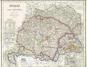
Ungarn und seine Nebenl�nder. Gro�e Landkarte von Ungarn und seinen Nachbarl�ndern mit kleiner Innenkarte von Buda und Pest. Grenzkolorierter Stahlstich nach Radefeld, revidiert von Ravenstein aus Meyer's Hand-Atlas 1867
Lingua: Tedesco
Editore: Hildburghausen: Bibliographischen Instituts, 1867
Da: historicArt Antiquariat & Kunsthandlung, Wiesbaden-Breckenheim, Germania
Valutazione del venditore 5 su 5 stelle
Mappa Prima edizione Copia autografata
EUR 60,00
Spedizione EUR 12,00
Spedito da Germania a U.S.A.Quantit�: 1 disponibili
Aggiungi al carrello1. gro�er Original-Stahlstich von Ravenstein (in der Platte signiert) auf r�ckseitig unbedrucktem B�ttenblatt aus Meyer's Hand-Atlas 1867, im Druck und von Hand grenz- und fl�chenkoloriert, extrem detailreiche und pr�zise Karte mit allen kleinen und gr��eren St�dten, Marktpl�tzen, Bergen, P�ssen, Fl�ssen und Seen, galt zum Zeitpunkt ihrer letzten Revision durch Ravenstein in der hier vorliegenden Fassung (1864) als pr�ziseste Landkarte der betreffenden Gebiete, bildliche Darstellung ca. 29 x 36 cm, Blattgr��e ca. 35 x 48 cm (jeweils H�he x Breite), sauber und sehr gut erhalten gro�er und/oder schwerer Artikel mit zus�tzlichen Kosten f�r Versand und Versicherung - heavy and/or oversized item with additional costs for shipping and insurance - will be dispatched enrolled in a solid mailing tube - please ask us before you order this article 2100 gr.
-
![Immagine del venditore per Ueber den spezifischen Unterschied des Christianismus vom Naturalismus, zur Beurtheilung einer Neuerung, welche mit dem Christennamen im Werke ist 1794 [LeatherBound] venduto da True World of Books](https://pictures.abebooks.com/inventory/md/md31534009265.jpg)
Ueber den spezifischen Unterschied des Christianismus vom Naturalismus, zur Beurtheilung einer Neuerung, welche mit dem Christennamen im Werke ist 1794 [LeatherBound]
Data di pubblicazione: 2025
EUR 21,28
Spedizione gratuita
Spedito da India a U.S.A.Quantit�: 18 disponibili
Aggiungi al carrelloLeatherBound. Condizione: New. BOOKS ARE EXEMPT FROM IMPORT DUTIES AND TARIFFS; NO EXTRA CHARGES APPLY. LeatherBound edition. Condition: New. Reprinted from 1794 edition. Leather Binding on Spine and Corners with Golden leaf printing on spine. NO changes have been made to the original text. This is NOT a retyped or an ocr'd reprint. Illustrations, Index, if any, are included in black and white. Each page is checked manually before printing. Pages: 63 As this print on demand book is reprinted from a very old book, there could be some missing or flawed pages, but we always try to make the book as complete as possible. Fold-outs, if any, are not part of the book. If the original book was published in multiple volumes then this reprint is of only one volume, not the whole set. Sewing binding for longer life, where the book block is actually sewn (smythe sewn/section sewn) with thread before binding which results in a more durable type of binding. Pages: 63 Language: German.
-

Provinz Brandenburg. Altkolorierte Landkarte von Brandenburg von der Uckermark im Norden bis zur Niederlausitz. Stahlstich von Radefeld revidiert von Ravenstein 1861
Lingua: Tedesco
Editore: Hildburghausen: Bibliographischen Instituts, 1861
Da: historicArt Antiquariat & Kunsthandlung, Wiesbaden-Breckenheim, Germania
Valutazione del venditore 5 su 5 stelle
Mappa Prima edizione Copia autografata
EUR 70,00
Spedizione EUR 12,00
Spedito da Germania a U.S.A.Quantit�: 1 disponibili
Aggiungi al carrello1. Original-Stahlstich von Radefeld (in der Platte signiert) auf r�ckseitig unbedrucktem Blatt, bildliche Darstellung ca. 29 x 36 cm, Blattgr��e ca. 37 x 48 cm, sehr detaillierte und pr�zise Karte, einzelne Tafel aus "Meyer's Hand-Atlas", von alter Hand sehr gewissenhaft grenzkoloriert, sauber und sehr gut erhalten 2100 gr.
-

Das K�nigreich der Niederlande mit den Grossherzothume Luxemburg, dem Herzogthume Limburg und K�nigreich Belgien. Gro�e Landkarte von Irland. Grenzkolorierter Stahlstich nach Radefeld, revidiert von Ravenstein aus Meyer's Hand-Atlas 1867
Lingua: Tedesco
Editore: Hildburghausen: Bibliographischen Instituts, 1867
Da: historicArt Antiquariat & Kunsthandlung, Wiesbaden-Breckenheim, Germania
Valutazione del venditore 5 su 5 stelle
Mappa Prima edizione
EUR 70,00
Spedizione EUR 12,00
Spedito da Germania a U.S.A.Quantit�: 1 disponibili
Aggiungi al carrello1. gro�er Original-Stahlstich auf r�ckseitig unbedrucktem B�ttenblatt aus Meyer's Hand-Atlas 1867, im Druck und von Hand sehr pr�zise grenzkoloriert, bildliche Darstellung ca. 37 x 29,5 cm, Blattgr��e ca. 48 x 37 cm (jeweils H�he x Breite), kleiner blasser Fleck neben dem Titel, im �u�ersten Blattrand leicht gegilbt, ansonsten sehr gut erhalten gro�er und/oder schwerer Artikel mit zus�tzlichen Kosten f�r Versand und Versicherung - heavy and/or oversized item with additional costs for shipping and insurance - will be dispatched enrolled in a solid mailing tube - please ask us before you order this article 2100 gr.
-

Ireland. Gro�e Landkarte von Irland. Grenzkolorierter Stahlstich nach Radefeld, revidiert von Ravenstein aus Meyer's Hand-Atlas 1867
Lingua: Tedesco
Editore: Hildburghausen: Bibliographischen Instituts, 1867
Da: historicArt Antiquariat & Kunsthandlung, Wiesbaden-Breckenheim, Germania
Valutazione del venditore 5 su 5 stelle
Mappa Prima edizione
EUR 70,00
Spedizione EUR 12,00
Spedito da Germania a U.S.A.Quantit�: 1 disponibili
Aggiungi al carrello1. gro�er Original-Stahlstich auf r�ckseitig unbedrucktem B�ttenblatt aus Meyer's Hand-Atlas 1867, im Druck und von Hand sehr pr�zise grenzkoloriert, bildliche Darstellung ca. 37 x 30 cm, Blattgr��e ca. 48 x 37 cm (jeweils H�he x Breite), sauber und sehr gut erhalten gro�er und/oder schwerer Artikel mit zus�tzlichen Kosten f�r Versand und Versicherung - heavy and/or oversized item with additional costs for shipping and insurance - will be dispatched enrolled in a solid mailing tube - please ask us before you order this article 2100 gr.
-
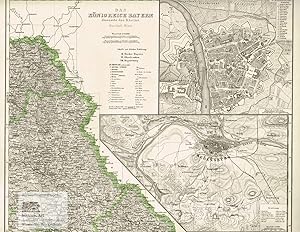
Das K�nigreich Bayern diesseits des Rheins. Nord�sl. Blatt. Gro�e Landkarte des K�nigreichs Bayern mit zwei Innenkarten mit Stadtgrundriss von W�rzburg am Main und Regensburg an der Donau mit Umgebung. Grenzkolorierter Stahlstich von Feuerstein nach Ravenstein aus Meyer's Hand-Atlas 1867
Lingua: Tedesco
Editore: Hildburghausen: Bibliographischen Instituts, 1867
Da: historicArt Antiquariat & Kunsthandlung, Wiesbaden-Breckenheim, Germania
Valutazione del venditore 5 su 5 stelle
Mappa Prima edizione Copia autografata
EUR 70,00
Spedizione EUR 12,00
Spedito da Germania a U.S.A.Quantit�: 1 disponibili
Aggiungi al carrello1. gro�er Original-Stahlstich von Feuerstein (in der Platte signiert) auf r�ckseitig unbedrucktem B�ttenblatt aus Meyer's Hand-Atlas 1867, im Druck und von Hand sehr pr�zise grenzkoloriert, bildliche Darstellung ca. 30 x 35,5 cm, Blattgr��e ca. 37 x 48 cm (jeweils H�he x Breite), sauber und sehr gut erhalten gro�er und/oder schwerer Artikel mit zus�tzlichen Kosten f�r Versand und Versicherung - heavy and/or oversized item with additional costs for shipping and insurance - will be dispatched enrolled in a solid mailing tube - please ask us before you order this article 2100 gr.
-
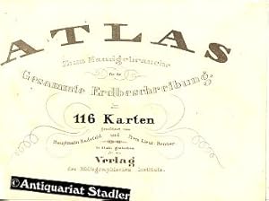
Atlas zum Handgebrauche f�r die Gesammte Erdbeschreibung in 116 Karten. Pfennig-Atlas. Gezeichnet vom Hauptmann Radefeld und Prem. Lieut. Renner. In Stahl gestochen von C. Ehricht.
Lingua: Tedesco
Editore: Hildburghausen: Bibliographisches Institut bzw. Schweinfurt: Geographische Gravir-Anstalt von Kleinknecht, ca., 1841
Da: Antiquariat im Kloster, Weilheim, BY, Germania
Valutazione del venditore 4 su 5 stelle
EUR 950,00
Spedizione EUR 60,00
Spedito da Germania a U.S.A.Quantit�: 1 disponibili
Aggiungi al carrelloCondizione: Sehr gut. 1 Bl. (Titel), 115 (entgegen der auf dem gestoch.Titel angegebenen 116 Karten listet das Verzeichnis 115 auf) meist grenzkolorierten Stahlstichkarten u. Stadtpl�ne, 1 Bl. Verzeichnis der Karten. - Der als "Meyer's Pfennig-Atlas" bekannt gewordene Taschenatlas ist in Lieferungen erschienen und daher h�ufig nicht komplett, hier jedoch vollst�ndig mit allen 115 Karten! - Buchr�cken mit Fehlstellen, einige Karten sind etwas fleckig, die Karten sind wahrscheinlich vom Buchbinder zart mit Bleistift - zur Einhaltung der Reihenfolge - nummeriert worden. Am Ende des Inhaltsverzeichnisses wird der Buchbinder n�mlich explizit aufgefordert, die Karten "in vorstehender Reihenfolge zu ordnen." Die Karten wurden zu einem f�r die Bev�lkerung erschwinglichen Preis zu je 8 Pfennig pro Blatt herausgegeben. Daher stammt der Name "Pfennig-Atlas". Die Karten sind in der Platte unterschiedlich datiert (1834 bis 1841). Der Atlas enth�lt u.a. Weltkarten, Landkarten, Regionalkarten, runde Stadtpl�ne von 24 St�dten (jeweils 2 auf einem Blatt). Au�ergew�hnlich sind auch die Landkarten von "Land Moriah" um Jerusalem, Pal�stina und die Reisen Jesu. Die kleinen Karten verf�gen �ber eine gro�e Liniensch�rfe und sind sehr detailliert gestochen. Zahlungen mit PayPal m�glich. Sprache: Deutsch Gewicht in Gramm: 500 OPappband mit R�ckenschildchen in Schuber. 13x19 cm quer.
-
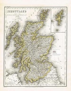
Schottland. Gro�e Landkarte von den Hebriden und den Orkney Islands im Norden bis Dumfries im S�den mit kleiner Innenkarte der Shetland Islands. Gro�er grenzkolorierter Stahlstich nach Radefeld, revidiert von Ravenstein aus Meyer's Hand-Atlas 1867
Lingua: Tedesco
Editore: Hildburghausen: Bibliographischen Instituts, 1867
Da: historicArt Antiquariat & Kunsthandlung, Wiesbaden-Breckenheim, Germania
Valutazione del venditore 5 su 5 stelle
Mappa Prima edizione
EUR 75,00
Spedizione EUR 12,00
Spedito da Germania a U.S.A.Quantit�: 1 disponibili
Aggiungi al carrello1. gro�er Original-Stahlstich auf r�ckseitig unbedrucktem B�ttenblatt aus Meyer's Hand-Atlas 1867, im Druck und von Hand sehr pr�zise grenzkoloriert, bildliche Darstellung ca. 37 x 29 cm, Blattgr��e ca. 48 x 37 cm (jeweils H�he x Breite), sauber und sehr gut erhalten gro�er und/oder schwerer Artikel mit zus�tzlichen Kosten f�r Versand und Versicherung - heavy and/or oversized item with additional costs for shipping and insurance - will be dispatched enrolled in a solid mailing tube - please ask us before you order this article 2100 gr.
-

Neueste Karte von Arkansas mit seinen Canaelen Strassen & Entfernungen der Hauptpunkte. Meyer, Joseph & Radefeld, Carl Neueste Karte von Arkansas mit seinen Canaelen Strassen. Antique Map, Steel Engraving 375 x 302mm Meyer, Hildburghau.
Editore: Meyer, Hildburghausen, 1851
Da: Antiquariat Reinhold Berg eK Inh. R.Berg, Regensburg, Germania
Membro dell'associazione: ILAB VDA
Valutazione del venditore 5 su 5 stelle
Mappa
EUR 95,00
Spedizione EUR 24,00
Spedito da Germania a U.S.A.Quantit�: 1 disponibili
Aggiungi al carrelloOther. Steel Engraving, hand-colored in outline by Meyer, Joseph & Radefeld, Carl, published 1851 by Meyer, Hildburghausen. Image size: 375 by 302mm (14 by 12 inches). From Meyer's acclaimed steel-engraved atlas, one of the finest German cartographic productions of the 19th century. Joseph Meyer (17961856) and Carl Christian Franz Radefeld (17881874) formed one of the most productive cartographic partnerships in 19th-century German publishing. Working from the Bibliographisches Institut in Hildburghausen, their collaboration produced the beautifully engraved Meyer's Gro?er Hand-Atlas (18431860), renowned across Europe for its precision and completeness. Radefeld was a master steel engraver whose meticulous work elevated Meyer's atlases above their competitors. Their North American maps draw on the best American survey sources of the era including Tanner's work and represent the finest German cartographic record of mid-19th-century America. These steel engravings, typically hand-colored in outline, are prized by collectors for their quality and historical depth.This antique map shows Arkansas with his canals, streets and distances from the main points. The map is equipped with many streets, routes, rivers, lakes, place names, etc. In the upper side we find a mileage scale and steamship routes: Little Rock - Pittsburg, Little Rock - Fort Gibson & Little Rock - New Orleans. In excellent condition. In excellent condition. 375 by 302mm (14 by 12 inches). 375 by 302mm (14 by 12 inches).
-

Neueste Karte von Arkansas mit seinen Canaelen Strassen & Entfernungen der Hauptpunkte. Nach den bessten Quellen verbessert. 1851. Meyer, Joseph & Radefeld, Carl Neueste Karte von Arkansas mit seinen Canaelen Strassen. Antique Map, Steel Engraving 374 x 299mm Bibliograph. Insti.
Editore: Bibliograph. Institut, Hildburghausen, 1851
Da: Antiquariat Reinhold Berg eK Inh. R.Berg, Regensburg, Germania
Membro dell'associazione: ILAB VDA
Valutazione del venditore 5 su 5 stelle
Mappa
EUR 100,00
Spedizione EUR 24,00
Spedito da Germania a U.S.A.Quantit�: 1 disponibili
Aggiungi al carrelloOther. Steel Engraving, hand-colored in outline by Meyer, Joseph & Radefeld, Carl, published 1851 by Bibliograph. Institut, Hildburghausen. Image size: 374 by 299mm (14 by 11 inches). From Meyer's acclaimed steel-engraved atlas, one of the finest German cartographic productions of the 19th century. Joseph Meyer (17961856) and Carl Christian Franz Radefeld (17881874) formed one of the most productive cartographic partnerships in 19th-century German publishing. Working from the Bibliographisches Institut in Hildburghausen, their collaboration produced the beautifully engraved Meyer's Gro?er Hand-Atlas (18431860), renowned across Europe for its precision and completeness. Radefeld was a master steel engraver whose meticulous work elevated Meyer's atlases above their competitors. Their North American maps draw on the best American survey sources of the era including Tanner's work and represent the finest German cartographic record of mid-19th-century America. These steel engravings, typically hand-colored in outline, are prized by collectors for their quality and historical depth.This antique map shows Arkansas with his canals, streets and distances from the main points. The map is equipped with many streets, routes, rivers, lakes, place names, etc. In the upper side we find a mileage scale and steamship routes: Little Rock - Pittsburg, Little Rock - Fort Gibson & Little Rock - New Orleans. In excellent condition. In excellent condition. 374 by 299mm (14 by 11 inches). 374 by 299mm (14 by 11 inches).
-
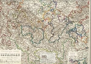
�bersichts-Karte von Th�ringen. Gro�e Landkarte von Th�ringen mit "politischem Colorit" mit kleiner Innenkarte der Meiningischen Parzelle Kamburg. Gro�er grenzkolorierter Stahlstich von Petters nach Radefeld, revidiert von Ravenstein aus Meyer's Hand-Atlas 1867
Lingua: Tedesco
Editore: Hildburghausen: Bibliographischen Instituts, 1867
Da: historicArt Antiquariat & Kunsthandlung, Wiesbaden-Breckenheim, Germania
Valutazione del venditore 5 su 5 stelle
Mappa Prima edizione Copia autografata
EUR 80,00
Spedizione EUR 12,00
Spedito da Germania a U.S.A.Quantit�: 1 disponibili
Aggiungi al carrello1. gro�er Original-Stahlstich von Petters (in der Platte signiert) auf r�ckseitig unbedrucktem B�ttenblatt aus Meyer's Hand-Atlas 1867, im Druck und von Hand sehr pr�zise grenzkoloriert, bildliche Darstellung ca. 34 x 43 cm, Blattgr��e ca. 37 x 48 cm (jeweils H�he x Breite), sauber und sehr gut erhalten gro�er und/oder schwerer Artikel mit zus�tzlichen Kosten f�r Versand und Versicherung - heavy and/or oversized item with additional costs for shipping and insurance - will be dispatched enrolled in a solid mailing tube - please ask us before you order this article 2100 gr.
-

Europa. Politische Uebersicht. Gro�e Landkarte der L�nder Europas mit Russland bis zum Ural. Pr�chtig grenzkolorierter Stahlstich von Major Radeveld, revidiert von Ravenstein aus Meyer's Hand-Atlas 1867
Lingua: Tedesco
Editore: Hildburghausen: Bibliographischen Instituts, 1867
Da: historicArt Antiquariat & Kunsthandlung, Wiesbaden-Breckenheim, Germania
Valutazione del venditore 5 su 5 stelle
Mappa Prima edizione
EUR 80,00
Spedizione EUR 12,00
Spedito da Germania a U.S.A.Quantit�: 1 disponibili
Aggiungi al carrello1. gro�er Original-Stahlstich nach Radeveld und Ravenstein auf r�ckseitig unbedrucktem B�ttenblatt aus Meyer's Hand-Atlas 1867, extrem detailreiche Darstellung, im Druck und von Hand sehr pr�zise grenzkoloriert, bildliche Darstellung ca. 30 x 37 cm, Blattgr��e ca. 37 x 47 cm (jeweils H�he x Breite), sauber und sehr gut erhalten gro�er und/oder schwerer Artikel mit zus�tzlichen Kosten f�r Versand und Versicherung - heavy and/or oversized item with additional costs for shipping and insurance - will be dispatched enrolled in a solid mailing tube - please ask us before you order this article 2100 gr.
-

Die Schweiz. Gro�e Landkarte der Schweiz von Schaffhausen im Norden bis Lugano im S�den. Grenzkolorierter Stahlstich nach Radefeld, revidiert von Ravenstein aus Meyer's Hand-Atlas 1867
Lingua: Tedesco
Editore: Hildburghausen: Bibliographischen Instituts, 1867
Da: historicArt Antiquariat & Kunsthandlung, Wiesbaden-Breckenheim, Germania
Valutazione del venditore 5 su 5 stelle
Mappa Prima edizione Copia autografata
EUR 80,00
Spedizione EUR 12,00
Spedito da Germania a U.S.A.Quantit�: 1 disponibili
Aggiungi al carrello1. gro�er Original-Stahlstich von Radefeld und Ravenstein (in der Platte signiert) auf r�ckseitig unbedrucktem B�ttenblatt aus Meyer's Hand-Atlas 1867, im Druck und von Hand grenzkoloriert, extrem detailreiche und pr�zise Karte mit allen kleinen und gr��eren St�dten, Marktpl�tzen, Bergen, P�ssen, Fl�ssen und Seen, galt zum Zeitpunkt ihrer letzten Revision durch Ravenstein in der hier vorliegenden Fassung (1863) als pr�ziseste Landkarte der Schweizerischen Eidgenossenschaft �berhaupt, bildliche Darstellung ca. 35 x 42 cm, Blattgr��e ca. 37 x 47 cm (jeweils H�he x Breite), sauber und sehr gut erhalten gro�er und/oder schwerer Artikel mit zus�tzlichen Kosten f�r Versand und Versicherung - heavy and/or oversized item with additional costs for shipping and insurance - will be dispatched enrolled in a solid mailing tube - please ask us before you order this article 2100 gr.
-
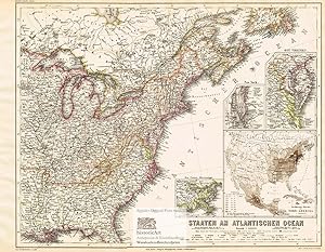
Staaten am Atlantischen Ozean. Large map of the Eastern States of the United States of America on the Atlantic Ocean with small inside maps of New York, Eastern Virginia and the Lower Mississippi. Colored steel engraving by Plath after Ravenstein from Meyer's Hand-Atlas 1867
Lingua: Tedesco
Editore: Hildburghausen: Bibliographischen Instituts, 1867
Da: historicArt Antiquariat & Kunsthandlung, Wiesbaden-Breckenheim, Germania
Valutazione del venditore 5 su 5 stelle
Mappa Prima edizione Copia autografata
EUR 80,00
Spedizione EUR 12,00
Spedito da Germania a U.S.A.Quantit�: 1 disponibili
Aggiungi al carrello1. gro�er Original-Stahlstich von Plath (in der Platte signiert) auf r�ckseitig unbedrucktem B�ttenblatt aus Meyer's Hand-Atlas 1867, im Druck und von Hand sehr pr�zise grenzkoloriert, bildliche Darstellung ca. 34 x 43 cm, Blattgr��e ca. 37 x 48 cm (jeweils H�he x Breite), sauber und sehr gut erhalten - gro�er und/oder schwerer Artikel mit zus�tzlichen Kosten f�r Versand und Versicherung - heavy and/or oversized item with additional costs for shipping and insurance - will be dispatched enrolled in a solid mailing tube - please ask us before you order this article 2100 gr.
-

Karte von Australien. Gro�e Landkarte von Australien mit Innenkarten von Port Philip und Melbourne, Port Jackson und Botany Bay und Neu Seeland (New Zealand). Grenzkolorierter Stahlstich von E.G. Ravenstein nach Major Radefeld aus Meyer's Hand-Atlas 1867
Lingua: Tedesco
Editore: Hildburghausen: Bibliographischen Instituts, 1867
Da: historicArt Antiquariat & Kunsthandlung, Wiesbaden-Breckenheim, Germania
Valutazione del venditore 5 su 5 stelle
Mappa Prima edizione Copia autografata
EUR 80,00
Spedizione EUR 12,00
Spedito da Germania a U.S.A.Quantit�: 1 disponibili
Aggiungi al carrello1. gro�er Original-Stahlstich von E.G. Ravenstein (in der Platte signiert) nach Radefeld auf r�ckseitig unbedrucktem B�ttenblatt aus Meyer's Hand-Atlas 1867, im Druck und von Hand sehr pr�zise grenzkoloriert, bildliche Darstellung ca. 33 x 44 cm, Blattgr��e ca. 36,5 x 47,5 cm (jeweils H�he x Breite), sauber und sehr gut erhalten gro�er und/oder schwerer Artikel mit zus�tzlichen Kosten f�r Versand und Versicherung - heavy and/or oversized item with additional costs for shipping and insurance - will be dispatched enrolled in a solid mailing tube - please ask us before you order this article 2100 gr.
-

Jran, Turan, Persien, Afghanistan, Beludschistan, Turkestan. Nach den besten Quellen entworfen und gezeichnet vom Major Radefeld. Gro�e Landkarte von Persien und Afghanistan vom Aral See im Norden bis zum Persischen Golf im S�den. Gro�er altkolorierter Stahlstich aus Meyer's Grossem Zeitungs-Atlas 1850
Editore: Hildburghausen: Bibliographischen Instituts, 1850
Da: historicArt Antiquariat & Kunsthandlung, Wiesbaden-Breckenheim, Germania
Valutazione del venditore 5 su 5 stelle
Mappa Prima edizione Copia autografata
EUR 120,00
Spedizione EUR 12,00
Spedito da Germania a U.S.A.Quantit�: 1 disponibili
Aggiungi al carrello1. gro�er Original-Stahlstich von Major Radefeld (in der Platte signiert) auf r�ckseitig unbedrucktem B�ttenblatt aus Meyer's Grossem Zeitungs-Atlas 1850, von alter Hand sehr pr�zise grenz- und fl�chenkoloriert, bildliche Darstellung ca. 30 x 36 cm, Blattgr��e ca. 36 x 44 cm (jeweils H�he x Breite), im rechten Blattrand au�erhalb der bildlichen Darstellung etwas Alterspatina, ansonsten sauber und sehr gut erhalten, sehr selten 2100 gr.
-

Asien 1849.
Editore: Hildburghausen, Bibliographisches Institut [um 1849]., 1849
Da: Antiquariat Burgverlag, Wien, Austria
Membro dell'associazione: ILAB VDA VDAO
Valutazione del venditore 5 su 5 stelle
EUR 75,00
Spedizione EUR 65,00
Spedito da Austria a U.S.A.Quantit�: 1 disponibili
Aggiungi al carrelloAltkol. gest. Karte. 23 x 29 cm.(Blattgr.) 19 x 23,5 (Plattengr.). Etwas gebr�unt, mit kl. Tintenflecken im w. Rand. vgl. Espenhorst 3.1.2.1 - Aus: Meyers Zeitungs-Atlas, der erstmals 1849 erschien. Gewicht in Gramm: 500.
-

Karte von Polynesien. Gro�e Landkarte von Australien und Neu Seeland, Micronesien, den Salomonen, Neu Caledonien, den Carolinen, Sandwich Inseln, Fidschi Inseln, Tonga, Tahiti, Marshall Inseln und Galapagos Inseln im Pazifischen Ozean. Grenzkolorierter Stahlstich von E.G. Ravenstein nach Major Radefeld aus Meyer's Hand-Atlas 1867
Lingua: Tedesco
Editore: Hildburghausen: Bibliographischen Instituts, 1867
Da: historicArt Antiquariat & Kunsthandlung, Wiesbaden-Breckenheim, Germania
Valutazione del venditore 5 su 5 stelle
Mappa Prima edizione Copia autografata
EUR 90,00
Spedizione EUR 12,00
Spedito da Germania a U.S.A.Quantit�: 1 disponibili
Aggiungi al carrello1. gro�er Original-Stahlstich von E.G. Ravenstein (in der Platte signiert) nach Radefeld auf r�ckseitig unbedrucktem B�ttenblatt aus Meyer's Hand-Atlas 1867, im Druck und von Hand sehr pr�zise grenzkoloriert, bildliche Darstellung ca. 34 x 44 cm, Blattgr��e ca. 37 x 47 cm (jeweils H�he x Breite), sauber und sehr gut erhalten gro�er und/oder schwerer Artikel mit zus�tzlichen Kosten f�r Versand und Versicherung - heavy and/or oversized item with additional costs for shipping and insurance - will be dispatched enrolled in a solid mailing tube - please ask us before you order this article 2100 gr.
-

Das Koenigreich D�nemark und die Herzogth�mer Schleswig-Holstein u. Lauenburg. Gro�e Landkarte von D�nemark, Schleswig-Holstein und Lauenburg mit sch�ner Innenkarte von Island und Stadtgrundriss von Kopenhagen. Grenzkolorierter Stahlstich nach Radefeld, revidiert von Ravenstein aus Meyer's Hand-Atlas 1867
Lingua: Tedesco
Editore: Hildburghausen: Bibliographischen Instituts, 1867
Da: historicArt Antiquariat & Kunsthandlung, Wiesbaden-Breckenheim, Germania
Valutazione del venditore 5 su 5 stelle
Mappa Prima edizione
EUR 90,00
Spedizione EUR 12,00
Spedito da Germania a U.S.A.Quantit�: 1 disponibili
Aggiungi al carrello1. gro�er Original-Stahlstich auf r�ckseitig unbedrucktem B�ttenblatt aus Meyer's Hand-Atlas 1867, im Druck und von Hand sehr pr�zise grenzkoloriert, bildliche Darstellung ca. 37 x 30 cm, Blattgr��e ca. 48 x 37 cm (jeweils H�he x Breite), sauber und sehr gut erhalten gro�er und/oder schwerer Artikel mit zus�tzlichen Kosten f�r Versand und Versicherung - heavy and/or oversized item with additional costs for shipping and insurance - will be dispatched enrolled in a solid mailing tube - please ask us before you order this article 2100 gr.
-

Karte des Erzherzogthums Oesterreich ob und unter der Enns 1849.
Editore: Hildburghausen, Bibliographisches Institut [1849]., 1849
Da: Antiquariat Burgverlag, Wien, Austria
Membro dell'associazione: ILAB VDA VDAO
Valutazione del venditore 5 su 5 stelle
EUR 120,00
Spedizione EUR 65,00
Spedito da Austria a U.S.A.Quantit�: 1 disponibili
Aggiungi al carrelloAltkolor. Stahlstich. 38 x 31, 5 cm.(Bildausschnitt.). Unter Passepartout. Etwas gebr�unt, mit kl. Tintenflecken im w. Rand. vgl. Espenhorst 3.1.2.1 - Aus: Meyers Hand-Atlas, der erstmals 1849 erschien. Mit gedrucktem Vermerk am oberen Rand: (Supplm. 26) No. 126. Gewicht in Gramm: 1000.
-
Neueste Karte Von Louisiana.
Editore: c.1849, Germany, 1849
Da: Alexandre Antique Prints, Maps & Books, Toronto, ON, Canada
Membro dell'associazione: ABAC ILAB
Valutazione del venditore 5 su 5 stelle
Mappa
EUR 243,89
Spedizione EUR 5,17
Spedito da Canada a U.S.A.Quantit�: 1 disponibili
Aggiungi al carrelloCondizione: Very Good. Mid 19th century map of Louisiana, featuring a large inset map of downtown New Orleans and a legend charting roads, towns, villages, bayous and rivers. There is also a table on steamboat routes and distances., Size : 292x363 (mm), 11.50x14.30 (Inches), Original Outline Coloring.
-

EUR 210,00
Spedizione EUR 50,00
Spedito da Spagna a U.S.A.Quantit�: 1 disponibili
Aggiungi al carrelloCondizione: ACEPTABLE. Meyers Grosser Zeitungs Atlas Stich Druck und Verlag des Bibliographischen Instituts in Hildburghausen Gez.v. Major Radefeld Rev. 1864 Comprende Galicia, Pa�s Vasco, Castilla, parte de Andalucia y Portugal. Con un peque�o plano de Madrid Formato (cm): 37x49.
-
![Immagine del venditore per Plan von Madrid 1844 - Maasstabe [Plano de Madrid 1844 a Escala] venduto da Frame](https://pictures.abebooks.com/inventory/md/md31204863640.jpg)
Plan von Madrid 1844 - Maasstabe [Plano de Madrid 1844 a Escala]
Editore: Hildburghausen, 1844
Arte / Stampa / Poster
EUR 355,00
Spedizione EUR 50,00
Spedito da Spagna a U.S.A.Quantit�: 1 disponibili
Aggiungi al carrelloCondizione: ACEPTABLE. Plano de Madrid realizado para la obra titulada Meyer's Hand Atlas y editado por el Instituto Bibliogr�fico de Hildburghausen. ["Meyer's Hand Atlas N� 33."] ; ["Verlag des Bibliographischen Instituts in Hildburghausen, Amsterdam, Paris u. Philadelphia."] . Formato (cm): 46x38.

![Immagine del venditore per [Composite Atlas from Atlas zum handgebrauche �] venduto da High Ridge Books, Inc. - ABAA](https://pictures.abebooks.com/inventory/md/md31423191372.jpg)