
Importo totale (1 articolo articoli):
Destinazione ordine:

cartes taride (204 risultati)
Vai alla pagina principale dei risultati di ricerca
Filtri di ricerca
Tipo di articolo
- Tutti i tipi di prodotto
- Libri (54)
- Riviste e Giornali (Nessun altro risultato corrispondente a questo perfezionamento)
- Fumetti (Nessun altro risultato corrispondente a questo perfezionamento)
- Spartiti (Nessun altro risultato corrispondente a questo perfezionamento)
- Arte, Stampe e Poster (Nessun altro risultato corrispondente a questo perfezionamento)
- Fotografie (Nessun altro risultato corrispondente a questo perfezionamento)
- Mappe (149)
- Manoscritti e Collezionismo cartaceo (1)
Condizioni Maggiori informazioni
Legatura
Ulteriori caratteristiche
- Prima ed. (3)
- Copia autograf. (Nessun altro risultato corrispondente a questo perfezionamento)
- Sovracoperta (1)
- Con foto (178)
- Non Print on Demand (203)
Lingua (4)
Spedizione gratuita
Paese del venditore
Valutazione venditore
-

Carte Routiere No. 3 Paris - Champagne ( Nord) - Ardennes Un Enfant Peut Guider Sa Mere Avec Les Cartes Taride Routieres
Editore: Cartes Taride, Paris
Da: Willis Monie-Books, ABAA, Cooperstown, NY, U.S.A.
Membro dell'associazione: ABAA ESA ILAB
Valutazione del venditore 5 su 5 stelle

Softcover. Condizione: Very Good-. Condizione sovraccoperta: No Dust Jacket. Several very small brown spots on rear cover. Tiny tears to left edge of front cover label. Written notations in pencil on a blank cloth panel. ; French text. Folded map issued with a cloth backing. Brentano's ink stamp on the front cover.
-
Grand Carte Routiere Centre De La France Section Est Bourgogne - Nivernais - Bourbonnais No. 1
Editore: A. Taride, Paris
Da: Willis Monie-Books, ABAA, Cooperstown, NY, U.S.A.
Membro dell'associazione: ABAA ESA ILAB
Valutazione del venditore 5 su 5 stelle
Softcover. Condizione: Very Good-. Condizione sovraccoperta: No Dust Jacket. Envelope is torn down one side and has general light wear. Map is clean. Price label and Brentano's ink stamp on the front of the envelope. ; French text. Folded map issued in a paper envelope.
-
Grand Carte Routiere Bretagne ( Nord) No. 5
Editore: A. Taride, Paris
Da: Willis Monie-Books, ABAA, Cooperstown, NY, U.S.A.
Membro dell'associazione: ABAA ESA ILAB
Valutazione del venditore 5 su 5 stelle
Softcover. Condizione: Very Good-. Condizione sovraccoperta: No Dust Jacket. Envelope has general light wear. Map is clean. ; French text. Folded map issued in a paper envelope.
-
Carte Routiere No. 9 Bretagne ( Sud)
Editore: Cartes Taride, Paris
Da: Willis Monie-Books, ABAA, Cooperstown, NY, U.S.A.
Membro dell'associazione: ABAA ESA ILAB
Valutazione del venditore 5 su 5 stelle
Softcover. Condizione: Very Good-. Condizione sovraccoperta: No Dust Jacket. Covers are slightly darkened. Price sticker obscures part of front cover label. ; French text. Folded map issued with a cloth backing.
-
Carte Routiere No. 2 Lorraine, Luxembourg
Editore: Cartes Taride, Paris
Da: Willis Monie-Books, ABAA, Cooperstown, NY, U.S.A.
Membro dell'associazione: ABAA ESA ILAB
Valutazione del venditore 5 su 5 stelle
Softcover. Condizione: Very Good-. Condizione sovraccoperta: No Dust Jacket. Covers are somewhat darkened. ; French text. Folded map issued with a cloth backing.
-
Carte Routiere No. 4 Paris, Normandie ( Nord)
Editore: Cartes Taride, Paris
Da: Willis Monie-Books, ABAA, Cooperstown, NY, U.S.A.
Membro dell'associazione: ABAA ESA ILAB
Valutazione del venditore 5 su 5 stelle
Softcover. Condizione: Good. Condizione sovraccoperta: No Dust Jacket. Front cover is soiled. Price sticker obscures part of front cover label. ; French text. Folded map issued with a cloth backing.
-
Carte Routiere No. 5 Bis Bretagne ( Ouest)
Editore: Cartes Taride, Paris
Da: Willis Monie-Books, ABAA, Cooperstown, NY, U.S.A.
Membro dell'associazione: ABAA ESA ILAB
Valutazione del venditore 5 su 5 stelle
Softcover. Condizione: Very Good-. Condizione sovraccoperta: No Dust Jacket. Covers are somewhat darkened. Price sticker obscures part of front cover label. ; French text. Folded map issued with a cloth backing.
-
Carte Routiere No. 26 Les Bords Du Rhin Cologne A Mayence
Editore: Cartes Taride, Paris
Da: Willis Monie-Books, ABAA, Cooperstown, NY, U.S.A.
Membro dell'associazione: ABAA ESA ILAB
Valutazione del venditore 5 su 5 stelle
Softcover. Condizione: Very Good-. Condizione sovraccoperta: No Dust Jacket. Covers are somewhat darkened. Price sticker obscures part of front cover label. ; French text. Folded map issued with a cloth backing.
-
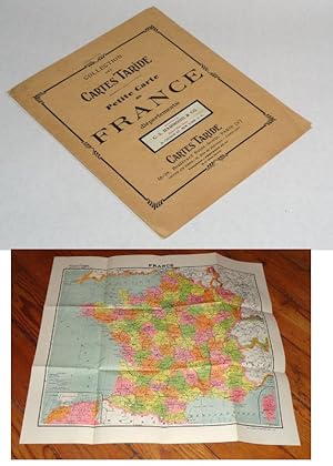
Collection Des Cartes Taride Petite Carte De France
Editore: C. S. Hammond & Company
Da: Pacific Rim Used Books LLC, Anacortes, WA, U.S.A.
Valutazione del venditore 5 su 5 stelle
Paperback. Circa 1920. 26.5 x 24 inches, a map of France, circa 1920 1 Good. Light shelf wear on the covers and map.
-
PLAN- GUIDE DE PARIS ; No. . 319
Editore: Cartes Taride, Paris France
Da: Falls Bookstore, Readsboro, VT, U.S.A.
Valutazione del venditore 4 su 5 stelle

Hardcover. Condizione: Good. No Jacket. MAPS (illustratore). Very Small book with red cloth binding and silver print on front cover and spine. Some slight fade on parts of print. Rear cover has two small hole sand some rubwear. Front endpapers are map of the Metropolitain. Rear endpapers have fold-out map. Sound and unmarked. 364 pages plus last block of 40 maps. maps. Contains: Conversion table old street names to current.; White Section, Index to streets indicating Metro stations, 128 pages; Blue pages Indispensible Addresses ,30 pages; Yellow Section Public transportation, 80 pages;
-
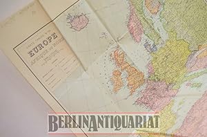
Europe, Afrique du Nord.
Editore: C. Michard o.J. (ca. 1942)., Paris, 1942
Da: BerlinAntiquariat, Karl-Heinz Than, Berlin, Germania
Membro dell'associazione: ILAB VDA
Valutazione del venditore 5 su 5 stelle
EUR 9,30
Spedizione EUR 8,95
Spedito da Germania a U.S.A.Quantit�: 1 disponibili
Aggiungi al carrelloGefaltet. Franz�sische Europa-Karte inklusive Nord-Afrika. Ma�stab 1:6700000. Zahlreiche mitteleurop�ische St�dte sind mit Bleistift unterstrichen worden. Konfliktzonen in Russland sind eingezeichnet, aber nicht deutlich markiert. Da in Frankreich kein Unterschied zwischen besetztem Gebiet und Vichy-Zone gemacht wird und auch Belgien, Luxemburg und die Niederlande als unabh�ngige Staaten eingezeichnet sind, handelt es sich hierbei wohl um eine Karte, die die Grenzen von 1940 angibt. Die Karte hat einige Gebrauchsspuren, befindet sich aber insgesamt in einem guten Zustand. Siehe Foto. I Blatt.
-

Carte Routiere No. 9 Bretagne ( Sud)
Lingua: Inglese
Editore: Cartes Taride, 1111
Da: Our Kind Of Books, Liphook, Regno Unito
Valutazione del venditore 5 su 5 stelle
EUR 11,93
Spedizione EUR 25,66
Spedito da Regno Unito a U.S.A.Quantit�: 1 disponibili
Aggiungi al carrelloSoft cover. Condizione: Very Good. No Jacket. This map is in very good condition. Tanning and some creasing present to the maps paper envelope. Otherwise a very good clean copy.
-
Guide Taride Paris Par Arrondissements Danlieue Desservie Par Le Metro Metro Autobus / Plan-Guide De Paris -- Includes Required Fold-out Maps
Lingua: Inglese
Editore: Cartes Taride
Hardcover. Condizione: Good. Hard Cover - Good - No dust jacket if issued - Repair to interior hinge and cover wear otherwise clean and tight - Text in French - Includes required fold-out maps - 304+ pages. - Circa 1950's.
-
Plan-Guide de Paris Repertoire des Rues Metropolitain Renseignements Indispensibles Ministeres, Ambassades et Consulats, Prefectures, Mairies, Police, Hopitaux, Postes et Telegraphes, Monuments, Musees, Parcs, Theatres et Attractions. Cartes Taride 1947.
Lingua: Francese
Editore: Cartes Taride,, London, England,, 1947
Da: Tony Hutchinson, Seale, Regno Unito
Valutazione del venditore 5 su 5 stelle
EUR 10,74
Spedizione EUR 23,75
Spedito da Regno Unito a U.S.A.Quantit�: 1 disponibili
Aggiungi al carrelloSoft cover. Condizione: Fair. 142 + 20 + xii pp. cover split at spine and detached, metro map attached (still in original folds) to front cover,20 numberd folded maps at rear very good + 10 other maps which are a bit worn.
-

Grande Carte Routiere des Environs de Paris, Section Nord Ouest dans un Rayon de 250 Kilom�tres, �chelle 1/250.000e, Tirage en Couleurs, Distances Kilom�triques. N� 4.
Editore: Paris: Taride 1900?., 1900
Da: Plurabelle Books Ltd, Cambridge, Regno Unito
Membro dell'associazione: GIAQ
Valutazione del venditore 5 su 5 stelle
EUR 14,32
Spedizione EUR 9,27
Spedito da Regno Unito a U.S.A.Quantit�: 1 disponibili
Aggiungi al carrelloMap. Condizione: Fair. large folding map in original pocket, cover worn and aged, map with signs of use and defects, date approx 1900?, original price "1 Fr. 25 net" Language: French.
-
Plan-Guide R?pertoire des Rues ? Paris (1er Arrondissement) M?tro-Autobus ? c. mid-20th century
Da: Blind-Horse-Books (ABAA), DeLand, FL, U.S.A.
Membro dell'associazione: ABAA ESA FABA ILAB IOBA
Valutazione del venditore 5 su 5 stelle
Condizione: Very Good. A compact Paris plan-guide combining detailed street maps with a directory of streets and integrated m?tro and autobus routes. Designed for practical navigation, this pocket guide covers central Paris with color-coded mapping, transit diagrams, and an alphabetical street index?an efficient tool for navigating the city in the pre-digital era. DETAILS: +++ Title: Plan-Guide R?pertoire des Rues ? Paris M?tro-Autobus +++ Publisher: Cartes Taride, Paris +++ Date: c. mid-20th century +++ Format: Flexible hardcover (pocket guide) +++ Size: 5.25 inches +++ Pagination: Indexed CONTENT HIGHLIGHTS: +++ Detailed color maps of Paris neighborhoods and arrondissements +++ Integrated m?tro and bus network diagrams +++ Alphabetical street directory with cross-references +++ Compact format designed for everyday urban navigation +++ Period cartography showing mid-century Paris layout CONDITION: Very Good. Bindings tight and square. Text clean with light, even age-toning. Moderate shelf handling wear. Previous owner?s name on first blank page. Historical Context ? Before the widespread use of digital navigation, compact guides such as those produced by Cartes Taride were essential tools for both residents and visitors in Paris. These guides combined cartography with transit information, reflecting the increasing complexity of urban mobility in the 20th century. With the expansion of the m?tro and bus networks, such publications helped users efficiently navigate the city?s dense street system. Today, they serve as useful historical references for the development of Parisian transportation and urban geography. Subjects: Paris maps, m?tro system, bus routes, street directories, urban navigation, French cartography, mid-century Paris, travel guides, Ephemera, Cartography, Transportation.
-
Cartes Taride Routieres, Lorraine, Luxembourg. First Edition. Map in Envelop. Circa Mid 1920's. Paris
Editore: Cartes Taride, Paris
Da: sonalsorises, Los angeles, CA, U.S.A.
Valutazione del venditore 2 su 5 stelle

Prima edizione
Condizione: Very Good. Map Illustrations (illustratore). First Edition. Original envelope contiaining motoring maps of Lorraine and Luxembourg. Very scarce.
-

Grande Carte Cycliste des Environs de Paris, Section Sud-Est dans un Rayon de 250 Kilom�tres, d'apr�s la Carte de L'Etat-Major, �chelle 1/250.000e, Tirage en 3 Couleurs, N� 7.
Editore: Paris: Taride 1900?., 1900
Da: Plurabelle Books Ltd, Cambridge, Regno Unito
Membro dell'associazione: GIAQ
Valutazione del venditore 5 su 5 stelle
EUR 21,48
Spedizione EUR 9,27
Spedito da Regno Unito a U.S.A.Quantit�: 1 disponibili
Aggiungi al carrelloMap. Condizione: Fair. large folding map in original pocket, cover worn and aged, map well preserved, date approx 1900?, original price "90 centimest", name in pencil to verso of map "Hart" Language: French.
-

Grande Carte Routiere Centre de la France. Section Ouest: Berry - Poitou - Touraine. �chelle 1/250.000e, Tirage en 4 Couleurs, Distances Kilom�triques. On back: A l'Usage des Cyclistes et Automobilistes. N� 12.
Editore: Paris: Taride 1900?., 1900
Da: Plurabelle Books Ltd, Cambridge, Regno Unito
Membro dell'associazione: GIAQ
Valutazione del venditore 5 su 5 stelle
EUR 21,48
Spedizione EUR 9,27
Spedito da Regno Unito a U.S.A.Quantit�: 1 disponibili
Aggiungi al carrelloMap. Condizione: Fair. large folding map in original pocket, pocket a little worn but map itself seems well preserved and clean and well folded, date approx 1900?, original price "1 Fr. 25 net" Language: French.
-
Cartes Taride. No. 1. Belgique. Plans - Guides - Cartes [Toute La France en 25 Sections]
Lingua: Francese
Editore: Cartes Taride, 18 et 20 Boulevard St-Denis, Paris, 1930
Da: K Books Ltd ABA ILAB, York, YORKS, Regno Unito
Membro dell'associazione: ABA ILAB PBFA
Valutazione del venditore 5 su 5 stelle
EUR 14,32
Spedizione EUR 22,59
Spedito da Regno Unito a U.S.A.Quantit�: 1 disponibili
Aggiungi al carrelloNo Binding. Condizione: Fair. Folding colour paper map one side only - 36 x 28 inches, and folds down to 7.5 x 5 inches. Accompanying publisher's brown sleeve case with black lettering. The map has tears and holes at the folded seams and the cover is grubby and split, Cartes Taride, 18 et 20 Boulevard St-Denis, Paris, circa 1930.
-
Carte Taride. Routiere No. 1. Nord de la France, Belgique [Ouest] ? Hotels et Garages Recommand�s
Lingua: Francese
Editore: Cartes Taride, 18 et 20 Boulevard St-Denis, Paris, 1930
Da: K Books Ltd ABA ILAB, York, YORKS, Regno Unito
Membro dell'associazione: ABA ILAB PBFA
Valutazione del venditore 5 su 5 stelle
EUR 14,32
Spedizione EUR 22,59
Spedito da Regno Unito a U.S.A.Quantit�: 1 disponibili
Aggiungi al carrelloNo Binding. Condizione: Fair. Folding colour paper map one side only - 36 x 28 inches, and folds down to 7.5 x 5 inches. Accompanying publisher's brown sleeve case with black lettering. The map has tears and holes at the folded seams and the cover is grubby and split, Cartes Taride, 18 et 20 Boulevard St-Denis, Paris, circa 1930.
-
Carte Taride. Routiere No. 3. Environs de Paris (Nord-Est) ? Hotels et Garages Recommand�s
Lingua: Francese
Editore: Cartes Taride, 18 et 20 Boulevard St-Denis, Paris, 1930
Da: K Books Ltd ABA ILAB, York, YORKS, Regno Unito
Membro dell'associazione: ABA ILAB PBFA
Valutazione del venditore 5 su 5 stelle
EUR 17,90
Spedizione EUR 22,59
Spedito da Regno Unito a U.S.A.Quantit�: 1 disponibili
Aggiungi al carrelloNo Binding. Condizione: Good. Folding colour paper map one side only - 36 x 28 inches, and folds down to 7.5 x 5 inches. Accompanying publisher's brown sleeve case with black lettering. The map has tears and holes at the folded seams and the cover is grubby and split, Cartes Taride, 18 et 20 Boulevard St-Denis, Paris, circa 1930.
-
Plan-Guide de Paris. R�pertoire des rues m�tropolitain. Renseignements indispensables. Minist�res - Ambassades et Consulats - Pr�fectures - Mairies - Police - H�pitaux - Postes et T�l�graphes - Monuments - Mus�es - Parcs - Cin�mas - Th��tres et Attractions etc. etc.
Editore: Cartes Taride ca. 1950, Paris, 1950
Da: Emile Kerssemakers ILAB, Heerlen, Paesi Bassi
Membro dell'associazione: ILAB NVVA
Valutazione del venditore 5 su 5 stelle
EUR 15,00
Spedizione EUR 33,00
Spedito da Paesi Bassi a U.S.A.Quantit�: 1 disponibili
Aggiungi al carrelloOriginal stiff wrappers. viii,304 pp.; ills, plans, maps, folding maps.; 14x10 cm. Text in French / Fran�ais - (covers slightly worn, previous owner's name, bit browned) Although very good, see picture 200g.
-

Le guide Taride des routes de France. Donne 800 itineraires e ville � ville avec e kilometrages entre chaque pays et la configuration g�ographique de la route.
Lingua: Francese
Editore: Paris, Taride, 1925
Da: Antiquariat Weinek, Salzburg, Austria
Valutazione del venditore 4 su 5 stelle
EUR 29,50
Spedizione EUR 25,50
Spedito da Austria a U.S.A.Quantit�: 1 disponibili
Aggiungi al carrello1 Blatt mit 28 Segmenten auf Leinen aufgezogen. In franz. Sprache. - Sch�ne Stra�enkarte aus dem ersten Viertel des 20. Jahrhunderts. - Insgesamt gut erhalten, stockfleckig.
-

Nouvelle Carte de l'Afrique. Echelle 1/8.000.000
Editore: Cartes Taride, Paris, 1923
Da: Kenneth Mallory Bookseller ABAA, Decatur, GA, U.S.A.
Membro dell'associazione: ABAA ILAB
Valutazione del venditore 5 su 5 stelle
Paperback. Condizione: Very good. Paperback. 139 x 108 cm [55 x 42.5 inches] unfolded. Toning to folds with some minor spots of loss, else a nice example. Folder worn and lightly chipped, but very good.
-

Lyonnais: Savoie, Dauphine
Editore: Cartes Taride Pour Cyclistes Et Automobilistes, Paris, no date: 1930's ?, 1930
EUR 14,32
Spedizione EUR 39,57
Spedito da Regno Unito a U.S.A.Quantit�: 1 disponibili
Aggiungi al carrelloHardcover. Cloth backed folding coloured map; No. 14 in the series; Some staining, vg. Book.
-
Carte Taride. Routiere No. 4. Paris, Normandie (Nord) ? Hotels et Garages Recommand�s
Lingua: Francese
Editore: Cartes Taride, 18 et 20 Boulevard St-Denis, Paris, 1930
Da: K Books Ltd ABA ILAB, York, YORKS, Regno Unito
Membro dell'associazione: ABA ILAB PBFA
Valutazione del venditore 5 su 5 stelle
EUR 26,25
Spedizione EUR 22,59
Spedito da Regno Unito a U.S.A.Quantit�: 1 disponibili
Aggiungi al carrelloNo Binding. Condizione: Fair. Folding colour paper map one side only - 36 x 28 inches, and folds down to 7.5 x 5 inches. Accompanying publisher's brown sleeve case with black lettering. The map has tears and holes at the folded seams and some foxing and the cover is grubby and split, Cartes Taride, 18 et 20 Boulevard St-Denis, Paris, circa 1930.
-

CARTE ROUTIERE N�13 - VENDEE
Editore: EDITIONS TARIDE
Da: Le-Livre, SABLONS, Francia
Membro dell'associazione: ILAB
Valutazione del venditore 5 su 5 stelle
Mappa
EUR 16,95
Spedizione EUR 42,00
Spedito da Francia a U.S.A.Quantit�: 1 disponibili
Aggiungi al carrelloCouverture souple. Condizione: bon. RO70122794: Non dat�. In-Plano. Broch�. Etat passable, Couv. l�g�rement pass�e, Dos satisfaisant, Int�rieur acceptable. Carte d�pliante en couleurs en 20 volets en couleurs. Cot� droit et bas de carte coup�e alt�rant la lecture de la carte. Note au stylo au dos de la carte. . . . Classification Dewey : 912-Atlas, cartes et plans.
-

CARTE CYCLISTES DU SUD OUEST DE LA FRANCE - BORDEAUX A TOULOUSE
Editore: EDITIONS TARIDE
Da: Le-Livre, SABLONS, Francia
Membro dell'associazione: ILAB
Valutazione del venditore 5 su 5 stelle
Mappa
EUR 16,95
Spedizione EUR 42,00
Spedito da Francia a U.S.A.Quantit�: 1 disponibili
Aggiungi al carrelloCouverture souple. Condizione: bon. RO70122801: Non dat�. In-Plano. Broch�. Etat d'usage, Couv. l�g�rement pass�e, Dos satisfaisant, Int�rieur acceptable. Carte d�pliante en couleurs en 32 volets, en couleurs au 1/250.000e. Trous sur le cot� gauche de la carte alt�rant la lecture. . . . Classification Dewey : 912-Atlas, cartes et plans.
-

CARTE ROUTIERE N�20 - GARONNE, LANDES
Editore: EDITIONS TARIDE
Da: Le-Livre, SABLONS, Francia
Membro dell'associazione: ILAB
Valutazione del venditore 5 su 5 stelle
Mappa
EUR 16,95
Spedizione EUR 42,00
Spedito da Francia a U.S.A.Quantit�: 1 disponibili
Aggiungi al carrelloCouverture souple. Condizione: bon. RO70122797: Non dat�. In-Plano. Broch�. Etat d'usage, Couv. l�g�rement pass�e, Dos satisfaisant, Int�rieur acceptable. Carte d�pliante en couleurs en 32 volets en couleurs au 1/250.000e. Quelques trous aux intersections de la carte alt�rant l�g�rement la lecture. . . . Classification Dewey : 912-Atlas, cartes et plans.


![Immagine del venditore per Cartes Taride. No. 1. Belgique. Plans - Guides - Cartes [Toute La France en 25 Sections] venduto da K Books Ltd ABA ILAB](https://pictures.abebooks.com/inventory/md/md32248986320.jpg)
![Immagine del venditore per Carte Taride. Routiere No. 1. Nord de la France, Belgique [Ouest] ? Hotels et Garages Recommand�s venduto da K Books Ltd ABA ILAB](https://pictures.abebooks.com/inventory/md/md32248988301.jpg)


