County maps (25 risultati)
- Brossura
- Prima edizione
Da: WONDERFUL BOOKS BY MAIL, CHICO-CA, CA, U.S.A.WONDERFUL BOOKS BY MAIL
Contatta il venditoreVenditore con 5 stelleCondizione: Usato - Molto buono
EUR 7,23
EUR 3,29 spedizioneSpedito in U.S.A.Quantità: 1 disponibili
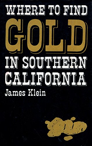
paperback. Condizione: Very Good. 1st Edition,3p; Third Printing. VERY GOOD Condition PAPERBACK, clean, solid, bright; GOLD & WHITE TITLES ON DARK BLACK PAPER COVERS. Several gold nuggets cover art; 103pg pages; California gold map. Tips & observations various techniques described.Amazingly enough, the old diggings are still the… best places to look for gold. Ride along with veteran prospector, James Klein, miner and author of numerous books on gold mining, as he discusses the possibilities for you to find gold within a day's drive anywhere in Southern California. Helpful detailed maps make locating gold easy. Learn about the geology of placer deposits, where to pan in the desert, how to stake a claim, and much more. Illustrated by Photos,drawings. County Maps (illustratore).

Lingua: Inglese
Editore: State Dept. Of Highways, Austin 1976
- Brossura
- Prima edizione
Da: The Wright Collection, Waxahachie, TX, U.S.A.The Wright Collection
Contatta il venditoreVenditore con 5 stelleMembro dell’associazione: TXBA
Condizione: Usato - Ottimo
EUR 13,56
EUR 5,71 spedizioneSpedito in U.S.A.Quantità: 1 disponibili
Soft cover. Condizione: Fine. 1st. 18" x 24.5" black & white map of Somervell County.
MARCELLUS NEW YORK. A Surban Community in the Heart of New York State's Fastest Growing Metropolitan Area
City-County-Office of Economic Development; with the assistance of the TownBoard of Marcellus and the Village Board of Marcellus
Editore: ***** Self Published ***** ca. 1963, Marcellus, NY 1963
- Brossura
Da: Riverow Bookshop, Owego, NY, U.S.A.Riverow Bookshop
Contatta il venditoreVenditore con 5 stelleCondizione: Usato
EUR 9,04
EUR 5,71 spedizioneSpedito in U.S.A.Quantità: 1 disponibili
Wraps/Spiral. Condizione: G/NO DUSTJACKET. Marcellus, NY: ***** Self Published *****. G/NO DUSTJACKET. ca. 1963. . Wraps/Spiral. Prepared for the Crescent Corset Company of Cortland, New York, to provide information on potential sites for a branch plant. . 4to., 34pp., 3, Rear cover stains . Black & White Photos/maps (illustrato…re).
- Brossura
Da: Ryde Bookshop Ltd, Isle of Wight, Regno UnitoRyde Bookshop Ltd
Contatta il venditoreVenditore con 5 stelleCondizione: Usato - Molto buono
EUR 4,77
EUR 23,13 spedizioneSpedito da Regno Unito a U.S.A.Quantità: 1 disponibili
Soft cover. Condizione: Very Good. Facsimile text edition of 1,500 copies. text edition. Remain of an old price label on back cover. with county maps (illustratore).
 Altre immagini
- Rilegato
Da: Cosmo Books, Shropshire., Regno UnitoCosmo Books
Contatta il venditoreVenditore con 5 stelleCondizione: Usato - Buono
EUR 19,34
EUR 13,79 spedizioneSpedito da Regno Unito a U.S.A.Quantità: 6 disponibili
Hardcover. Condizione: Good. Condizione sovraccoperta: Good. 48 pages with 19 colour maps & plans (22 x 29 cms), each with text to the rear. Publisher's original blue boards, spine with gilt lettering, and dustwrapper. All in good condition, with mildly worn dustwrappers. The maps used in this edition appeared originally in Thom…as Moule's English Counties Delineated, 1830-36. The exquisite Victorian maps depicting England's counties and cities, presented in a large format, are the work of the esteemed British cartographer Thomas Moule. Thomas Moule is celebrated as one of the premier mapmakers of the Victorian era and is recognized as a true successor to John Speed in the annals of British cartography. His meticulously crafted maps of counties and cities serve as a detailed historical record of 19th-century England. Initially released in collectible segments from 1830 to 1837, these maps were later compiled into the comprehensive two-volume work titled The English Counties Delineated. Moule honored the antiquity and heritage of each county by incorporating pastoral and monument views within the maps, all elegantly framed by cartouches, festoons, and architectural embellishments in various historical styles. The bookãããs introduction outlines Mouleãããs career as a writer and antiquarian, situating his renowned maps within the context of the technical cartographic advancements of his time. It explores the diverse artistic and cultural influences reflected in Mouleãããs work, where he merges precise cartography with ornate architectural frames and evocative, Romantic pastoral scenes of the England he cherished. However, beneath this portrayal of antiquity lies the influence of the British Industrial Revolution. Mouleãããs maps are significantly shaped by the pioneering efforts of the Ordnance Survey and document the relentless expansion of major cities and the rapid proliferation of railways. Size: 23.5 x 29.5 cms. Category: Varied Books; Featured Items; Hardback Books; ISBN: 185891194X. ISBN/EAN: 9781858911946. This item may require more postage than the rates shown for delivery outside the UK. If extra postage is required we will contact you before processing your order and you will be given the details and option to decline the extra cost. Cosmo Books : 29 years on ABE, 47 years taking care of customers. A bookseller you can rely on.
 Altre immagini
- Rilegato
Da: Cosmo Books, Shropshire., Regno UnitoCosmo Books
Contatta il venditoreVenditore con 5 stelleCondizione: Usato - Buono
EUR 19,34
EUR 13,79 spedizioneSpedito da Regno Unito a U.S.A.Quantità: 2 disponibili
Hardcover. Condizione: Good. Condizione sovraccoperta: Good. 48 pages with 19 colour maps & plans (22 x 29 cms), each with text to the rear. Publisher's original red boards, spine with gilt lettering, and dustwrapper. All in good condition, with mildly worn dustwrappers. The maps used in this edition appeared originally in Thoma…s Moule's English Counties Delineated, 1830-36. The exquisite Victorian maps depicting England's counties and cities, presented in a large format, are the work of the esteemed British cartographer Thomas Moule. Thomas Moule is celebrated as one of the premier mapmakers of the Victorian era and is recognized as a true successor to John Speed in the annals of British cartography. His meticulously crafted maps of counties and cities serve as a detailed historical record of 19th-century England. Initially released in collectible segments from 1830 to 1837, these maps were later compiled into the comprehensive two-volume work titled The English Counties Delineated. Moule honored the antiquity and heritage of each county by incorporating pastoral and monument views within the maps, all elegantly framed by cartouches, festoons, and architectural embellishments in various historical styles. The bookãããs introduction outlines Mouleãããs career as a writer and antiquarian, situating his renowned maps within the context of the technical cartographic advancements of his time. It explores the diverse artistic and cultural influences reflected in Mouleãããs work, where he merges precise cartography with ornate architectural frames and evocative, Romantic pastoral scenes of the England he cherished. However, beneath this portrayal of antiquity lies the influence of the British Industrial Revolution. Mouleãããs maps are significantly shaped by the pioneering efforts of the Ordnance Survey and document the relentless expansion of major cities and the rapid proliferation of railways. Size: 23.5 x 29.5 cms. Category: Varied Books; Featured Items; Hardback Books; ISBN: 185891194X. ISBN/EAN: 9781858911946. This item may require more postage than the rates shown for delivery outside the UK. If extra postage is required we will contact you before processing your order and you will be given the details and option to decline the extra cost. Cosmo Books : 29 years on ABE, 47 years taking care of customers. A bookseller you can rely on.
 Altre immagini
- Rilegato
Da: Cosmo Books, Shropshire., Regno UnitoCosmo Books
Contatta il venditoreVenditore con 5 stelleCondizione: Usato - Buono
EUR 19,34
EUR 13,79 spedizioneSpedito da Regno Unito a U.S.A.Quantità: 2 disponibili
Hardcover. Condizione: Good. Condizione sovraccoperta: Good. 48 pages with 19 colour maps & plans (22 x 29 cms), each with text to the rear. Publisher's original green boards, spine with gilt lettering, and dustwrapper. All in good condition, with mildly worn dustwrappers. The maps used in this edition appeared originally in Tho…mas Moule's English Counties Delineated, 1830-36. The exquisite Victorian maps depicting England's counties and cities, presented in a large format, are the work of the esteemed British cartographer Thomas Moule. Thomas Moule is celebrated as one of the premier mapmakers of the Victorian era and is recognized as a true successor to John Speed in the annals of British cartography. His meticulously crafted maps of counties and cities serve as a detailed historical record of 19th-century England. Initially released in collectible segments from 1830 to 1837, these maps were later compiled into the comprehensive two-volume work titled The English Counties Delineated. Moule honored the antiquity and heritage of each county by incorporating pastoral and monument views within the maps, all elegantly framed by cartouches, festoons, and architectural embellishments in various historical styles. The bookãããs introduction outlines Mouleãããs career as a writer and antiquarian, situating his renowned maps within the context of the technical cartographic advancements of his time. It explores the diverse artistic and cultural influences reflected in Mouleãããs work, where he merges precise cartography with ornate architectural frames and evocative, Romantic pastoral scenes of the England he cherished. However, beneath this portrayal of antiquity lies the influence of the British Industrial Revolution. Mouleãããs maps are significantly shaped by the pioneering efforts of the Ordnance Survey and document the relentless expansion of major cities and the rapid proliferation of railways. Size: 23.5 x 29.5 cms. Category: Varied Books; Featured Items; Hardback Books; ISBN: 185891194X. ISBN/EAN: 9781858911946. This item may require more postage than the rates shown for delivery outside the UK. If extra postage is required we will contact you before processing your order and you will be given the details and option to decline the extra cost. Cosmo Books : 29 years on ABE, 47 years taking care of customers. A bookseller you can rely on.
Editore: State Dept. Of Highways, Austin 1989
- Prima edizione
Da: The Wright Collection, Waxahachie, TX, U.S.A.The Wright Collection
Contatta il venditoreVenditore con 5 stelleMembro dell’associazione: TXBA
Condizione: Usato - Quasi ottimo
EUR 13,56
EUR 5,71 spedizioneSpedito in U.S.A.Quantità: 1 disponibili
Condizione: Near Fine. 1st. 18" x 24.5" black & white map of Limestone County.
Editore: State Dept. Of Highways, Austin 1989
- Prima edizione
Da: The Wright Collection, Waxahachie, TX, U.S.A.The Wright Collection
Contatta il venditoreVenditore con 5 stelleMembro dell’associazione: TXBA
Condizione: Usato - Ottimo
EUR 13,56
EUR 5,71 spedizioneSpedito in U.S.A.Quantità: 1 disponibili
Condizione: Fine. 1st. 18" x 24.5" black & white map of Bell County.
Editore: State Dept. Of Highways, Austin 1989
- Prima edizione
Da: The Wright Collection, Waxahachie, TX, U.S.A.The Wright Collection
Contatta il venditoreVenditore con 5 stelleMembro dell’associazione: TXBA
Condizione: Usato - Ottimo
EUR 13,56
EUR 5,71 spedizioneSpedito in U.S.A.Quantità: 1 disponibili
Condizione: Fine. 1st. 18" x 25" black & white map of Hill County.
Editore: D & L MAP SERVICE, Arlington 1986
Da: The Wright Collection, Waxahachie, TX, U.S.A.The Wright Collection
Contatta il venditoreVenditore con 5 stelleMembro dell’associazione: TXBA
Condizione: Usato - Molto buono
EUR 18,08
EUR 5,71 spedizioneSpedito in U.S.A.Quantità: 1 disponibili
Condizione: Very Good. 23" x 35" two sided map of four Texas counties.
Editore: Hanover County Board of Supervisors, Hanover County, VA 1972
- Brossura
- Prima edizione
Da: WILLIAM BLAIR BOOKS, Richmond, VA, U.S.A.WILLIAM BLAIR BOOKS
Contatta il venditoreVenditore con 5 stelleCondizione: Usato - Molto buono
EUR 31,20
EUR 4,39 spedizioneSpedito in U.S.A.Quantità: 1 disponibili
Spiral Bound. Condizione: Very Good Book. First Edition. Spiral bound with stiff paper covers. Book is clean, tight and unmarked. Fold out maps intact. Photographs, Maps and Charts (illustratore).

Antiquities of Mills County, Iowa. Written by Seth Dean. An article published by the Smithsonian Institution in 1881; 5 Pages, 2 sketch maps.
ANTIQUITIES OF MILLS COUNTY, IOWA: MOUNDS, SITES, AND SKETCH MAPS
Editore: Smithsonian Institution, Washington 1881
Da: Cosmo Books, Shropshire., Regno UnitoCosmo Books
Contatta il venditoreVenditore con 5 stelleCondizione: Usato - Molto buono
EUR 13,01
EUR 13,79 spedizioneSpedito da Regno Unito a U.S.A.Quantità: 4 disponibili
Booklet - Unbound Pages. Condizione: Very Good. A descriptive account of mound groups and associated archaeological features in Mills County, supported by two sketch maps. The article outlines their dimensions, distribution, and the limited artefacts recovered. 5 Pages, 2 sketch maps. An authentic standalone article, extracted f…rom a larger volume. Not a reprint or reproduction, but an original work in its own right. Preserved in a modern card cover, prepared for practicality - an unassuming but serviceable presentation that favours function over finery. Size: 16 x 24 cms. Category: Smithsonian Institution; All Under £15; Cosmo Books : 29 years on ABE, 47 years taking care of customers. A bookseller you can rely on.
Lingua: Inglese
Editore: Cumming Publishers, Stratford, ON. 1982
- Rilegato
Da: Old Favorites Bookshop LTD (since 1954), Stouffville, ON, CanadaOld Favorites Bookshop LTD (since 1954)
Contatta il venditoreVenditore con 4 stelleCondizione: Usato - Molto buono
EUR 85,90
EUR 8,78 spedizioneSpedito da Canada a U.S.A.Quantità: 1 disponibili
Boards with Cloth Spine. Condizione: Very Good Condition. . Blue boards wht black cloth spine. Front cover illustrated with Gilt County of Perth Crest and Gilt lettering. This book is large and may require additional postage. pHOTOS AVAILABLE ON REQUEST. Illustrated with Maps and B/W Photos. (illustratore).
Lingua: Inglese
Editore: Offset Edition, Port Elgin, ON. 1971
- Rilegato
Da: Old Favorites Bookshop LTD (since 1954), Stouffville, ON, CanadaOld Favorites Bookshop LTD (since 1954)
Contatta il venditoreVenditore con 4 stelleCondizione: Usato - Molto buono
EUR 113,02
EUR 8,78 spedizioneSpedito da Canada a U.S.A.Quantità: 1 disponibili
Hardcover. Condizione: Very Good Condition. Condizione sovraccoperta: No Dust Jacket. As Issued. Limited Edition 1,500 Copies. Including City of Ottawa. Edited by Ross Cumming. Limited numbered edition. This book is large and may require additional postage. Photos available on request. Illustrationed with Maps and Illustrations…(illustratore).
Editore: Board of County Auditors, Detroit MI 1930
- Rilegato
- Prima edizione
Da: A Few Books More. . ., Billings, MT, U.S.A.A Few Books More. . .
Contatta il venditoreVenditore con 5 stelleCondizione: Usato - Quasi ottimo
EUR 63,29
EUR 5,27 spedizioneSpedito in U.S.A.Quantità: 1 disponibili
Hardcover. Condizione: Near Fine. No Jacket. 1st Edition. 8 vo, 366 pp, including Index and Appendices. This is a good looking book Bound in full leatherette with a gold illustration on the front cover: a Roman charioteer drawn by two horses, with puffy clouds in the background. Title and design in raised lettering on spine. "19…30" on the base of the spine. Edges and corners are a moderately worn. Binding is sound and square. minor notes by a previous bookseller on the first fep. Weight: 1lb 12oz. Eight (8) fold-out maps (illustratore).
 Altre immagini
Lingua: Inglese
Editore: J. & F. Tallis 1848
- Rilegato
Da: Ely Books, ELY, CAMBS, Regno UnitoEly Books
Contatta il venditoreVenditore con 5 stelleCondizione: Usato - Molto buono
EUR 152,76
EUR 24,33 spedizioneSpedito da Regno Unito a U.S.A.Quantità: 1 disponibili
Hardcover. Condizione: Very Good. PAGES: xxii, 936, + maps & plates. The engraved title page reads: Barclays Universal English Dictionary Improved. BINDING: Half leather. CONDITION: Covers detached; damp staining to the first couple of plates and maps; foxing to many of the maps and plates (some heavy and some very clean). SOLD…AS A COLLECTION OF MAPS. Size: 11 X 8 1/2 Inches. Illustrated with 51 County MAPS (numbered: 2-52), 6 Plates & 4 Portraits. (illustratore).
Lingua: Inglese
Editore: Peter Martin Associates Limited, Toronto 1969
- Rilegato
Da: Old Favorites Bookshop LTD (since 1954), Stouffville, ON, CanadaOld Favorites Bookshop LTD (since 1954)
Contatta il venditoreVenditore con 4 stelleCondizione: Usato - Molto buono
EUR 226,05
EUR 8,78 spedizioneSpedito da Canada a U.S.A.Quantità: 1 disponibili
Hardcover. Condizione: Very Good Condition. Condizione sovraccoperta: No Dust Jacket. As Issued. Mustard color cloth binding with black illustrations of original title page on front covr. 64pp. Top and bottom of spine aand corners of binding bumped. Content clean, bright and sound. No interior faults. This book may require addit…ional postage. Photos available on request. B/W Maps and Drawings (illustratore).
- Rilegato
Da: A Few Books More. . ., Billings, MT, U.S.A.A Few Books More. . .
Contatta il venditoreVenditore con 5 stelleCondizione: Usato - Discreto
EUR 49,73
EUR 5,27 spedizioneSpedito in U.S.A.Quantità: 1 disponibili
Leather Bound. Condizione: Fair. Illustrated throughout with b/w photos. Two MAPS of Edgar Co. 1. Bird's eye view by J.J.Stoner, and 2. County Highway Map, 1969. (illustratore).
Editore: Constable, London 1913
- Rilegato
- Prima edizione
Da: Appleford Bookroom, Abingdon, OXON, Regno UnitoAppleford Bookroom
Contatta il venditoreVenditore con 5 stelleCondizione: Usato
EUR 85,93
EUR 33,54 spedizioneSpedito da Regno Unito a U.S.A.Quantità: 1 disponibili
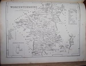
Half Leather. Condizione: Very Good for Age. Condizione sovraccoperta: Leather Case, No Jacket. First Edition LEATHER. brown leather with matching cloth folio, gilt blocked spine; clean text & sound binding. Marbled endpapers. Victoria County History for Worcester. Very good condition for age. This volume covers the Halfshire Hu…ndred, in modren terms from Kidderminster in the west across to Birmingham in the east. from Dudlry & Halesowen in the north to Droitwich in the south. Book in excellent half leather condition with a fine private booplate at front Size: Large Folio. Maps, Plans, Plates, Photos (illustratore).
Editore: St Catherine's Press, London
- Rilegato
- Mappa
Da: Appleford Bookroom, Abingdon, OXON, Regno UnitoAppleford Bookroom
Contatta il venditoreVenditore con 5 stelleCondizione: Usato
EUR 250,61
EUR 33,54 spedizioneSpedito da Regno Unito a U.S.A.Quantità: 1 disponibili
Hard Covers. Condizione: Very Good for Age. No Jackets. First Editions. 4to, red cloth, teg, gilt front & spine, minor wear but nothing serious, overall an excellent set of first 3 vols of Durham in VCH series. Such sets are rare these days, esp. in good condition Size: 4to. Many Plates Plans & Foldout Maps Photos. (illustratore…).
Editore: Constable, London
- Rilegato
- Prima edizione
Da: Appleford Bookroom, Abingdon, OXON, Regno UnitoAppleford Bookroom
Contatta il venditoreVenditore con 5 stelleCondizione: Usato
EUR 286,42
EUR 33,54 spedizioneSpedito da Regno Unito a U.S.A.Quantità: 1 disponibili
All Hardback. Condizione: Very Good for Age SRREY. No Jackets. All First Editions. 4to, exlib but fine condition for age, usual illustrations, plans and maps for this series. Teg. + red cloth blocked gilt front & spine. Chronology, . A comprehensive guide to the history political & ecclesiastical , topographical of Surrey and an… extensive index. Easly sets in good shape are quite rare these days. Size: 4to. Many Drawings, Maps & Photos. (illustratore).
 Altre immagini
Editore: Royal Geographical Society, London. 1932
- Brossura
Da: Asia Bookroom ANZAAB/ILAB, Canberra, ACT, AustraliaAsia Bookroom ANZAAB/ILAB
Contatta il venditoreVenditore con 5 stelleCondizione: Usato
EUR 311,68
EUR 18,65 spedizioneSpedito da Australia a U.S.A.Quantità: 1 disponibili
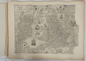
Twenty one loose maps with tissue guards, printed on sheets 49.5 x 63.5 cm in the original folio title-wrappers, the maps with some edge wear and toning but on the whole in very good condition, the wrappers browned and stained, torn, with minor loss, at the foot of the title wrapper, small closed edge tears, now re-enforced with… archival material and sound. Lacking the introductory notes by Edward Heawood. The complete suite of maps: an impressive production. The first map is a general map of England and Ireland, by an unknown author, 1594; nineteen county maps; and a final sheet of miniature county maps printed as a deck of playing-cards. The county maps proper vary in date from Saxton's ?Southamtonia? of 1575 to John Speed's version of Norden's map of Sussex, dated 1610. A contemporary reviewer dubbed it " a rich cartographical feast" allowing easy access to rare and valuable maps and comparison of maps by different cartographers for the same county. The county maps reproduced include five by Christopher Saxton, three by John Norden, Philip Symonson's map of Eastern Kent, published in 1596, a series of seven maps, dating from the early years of the seventeenth century, two maps prepared for Camden and two published by John Speed.
 Altre immagini
- Rilegato
Da: Addyman Books, Hay-on-Wye, Regno UnitoAddyman Books
Contatta il venditoreVenditore con 5 stelleCondizione: Usato
EUR 119,34
EUR 27,81 spedizioneSpedito da Regno Unito a U.S.A.Quantità: 1 disponibili
Longman Rees and Co. 1839. Early Edition. Hardback. No DW. Brown textured cloth. 9cm x 12.5cm. Linen-backed fold-out map in colour 35cm x 42cm . Ownership signature to inside cover. A lovely copy.
Editore: Roe Brothers (1879), St. John & Portland, N.B. 1879
Da: Schooner Books Ltd.(ABAC/ALAC), Halifax, NS, CanadaSchooner Books Ltd.(ABAC/ALAC)
Contatta il venditoreVenditore con 4 stelleCondizione: Usato
EUR 248,65
EUR 21,95 spedizioneSpedito da Canada a U.S.A.Quantità: 1 disponibili
Eleven separate single sheets Pp. From "Atlas of the Maritime Provinces of the Dominion of Canada. With Historical and Geological Descriptions." Published 1879 by the Roe Brothers, St. John & Portland, N.B. Maps include County of Gloucester [Plate #35], Counties of Restigouche and Madawaska [Plate #24 & 25]; County of Northumber…land [Plate #38 & 39];County of Kent[Plate #41];County of Saint John[Plate #47]; Counties of Sunbury and Queens[Plate #43];County of York[Plate #31];County of Kings[Plate #45];County of Victoria[Plate #27]; County of Carleton [Plate #29]; County of Charlotte [Plate #33] All maps have minor damp staining and tears to edges but generally very good. All are single sheet with some topographic detail except for Northumberland & Restigouche and Madawaska which are double sheets Each single sheet with some topographic detail.


