
Importo totale (1 articolo articoli):
Destinazione ordine:

great game (27 risultati)
Vai alla pagina principale dei risultati di ricerca
Filtri di ricerca
Tipo di articolo
- Tutti i tipi di prodotto
- Libri (24)
- Riviste e Giornali (1)
- Fumetti (Nessun altro risultato corrispondente a questo perfezionamento)
- Spartiti (Nessun altro risultato corrispondente a questo perfezionamento)
- Arte, Stampe e Poster (Nessun altro risultato corrispondente a questo perfezionamento)
- Fotografie (Nessun altro risultato corrispondente a questo perfezionamento)
- Mappe (2)
- Manoscritti e Collezionismo cartaceo (Nessun altro risultato corrispondente a questo perfezionamento)
Condizioni Maggiori informazioni
- Nuovo (7)
- Come nuovo, Ottimo o Quasi ottimo (2)
- Molto buono o Buono (7)
- Discreto o Mediocre (Nessun altro risultato corrispondente a questo perfezionamento)
- Come descritto (11)
Legatura
Ulteriori caratteristiche
- Prima ed. (3)
- Copia autograf. (Nessun altro risultato corrispondente a questo perfezionamento)
- Sovracoperta (2)
- Con foto (18)
- Non Print on Demand (26)
Lingua (2)
Spedizione gratuita
Paese del venditore
Valutazione venditore
-

Yahtzee Score Sheets: Large Score Pads / Book
Lingua: Inglese
Editore: Independently published, 2020
Da: Lexington Books Inc, Idaho Falls, ID, U.S.A.
Valutazione del venditore 5 su 5 stelle

Paperback. Condizione: Very Good.
-
DISCOVER THE GREAT TASTE OF GAME; from banquets to barbecues.
Lingua: Inglese
Da: Callahan and Company Booksellers, Peterborough, NH, U.S.A.
Valutazione del venditore 5 su 5 stelle
Paperbound. Condizione: Very fine. Foresight/ Countryside Alliance, London, circa 1999. Illustrated with color photographs. 6" x 8.25". 12 pp. Paperbound. Recipes for pheasant, pigeon, partridge, grouse, duck, rabbit, venison. Compiled to encourage the consumption of game by sportsmen, and those why buy ready prepared game from game dealers. Very fine.
-
EUR 5,93
Spedizione EUR 12,67
Spedito da Regno Unito a U.S.A.Quantit�: 1 disponibili
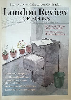
Aggiungi al carrelloSoft cover. Condizione: Very Good. 44 pages. Murray Sayle "Hydrocarbon Civilisation" / R W Johnson "Who was to blame for Rwanda?" / John Upton "Labour's Threat to Criminal Justice" / A D Nuttall "Milton Misread" / Germaine Greer "In praise of Lucy Hutchinson" / Frank Kermode Gielgud" / Paul Smith "Ornamentalism : How the British Saw Their Empire" / Robert Irwin "Tournament of shadows: The Great Game and the Race for Empire in Asia".
-

Egg Production and Incubation
Editore: The Game Conservancy
Da: WeBuyBooks, Rossendale, LANCS, Regno Unito
Valutazione del venditore 5 su 5 stelle
EUR 8,64
Spedizione EUR 5,99
Spedito da Regno Unito a U.S.A.Quantit�: 1 disponibili
Aggiungi al carrelloCondizione: Good. Most items will be dispatched the same or the next working day. A copy that has been read but remains in clean condition. All of the pages are intact and the cover is intact and the spine may show signs of wear. The book may have minor markings which are not specifically mentioned. Minor shelfwear. No jacket with clear contents.
-
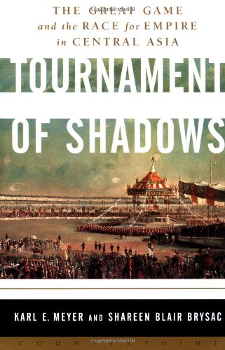
Tournament of Shadows: The Great Game and the Race for Empire in Central Asia Meyer, Karl E. and Brysac, Shareen Blair
Da: Aragon Books Canada, OTTAWA, ON, Canada
Valutazione del venditore 3 su 5 stelle

EUR 30,55
Spedizione EUR 20,07
Spedito da Canada a U.S.A.Quantit�: 1 disponibili
Aggiungi al carrelloCondizione: New.
-
Tournament of Shadows: The Great Game and the Race for Empire in Central Asia Meyer, Karl E. and Brysac, Shareen Blair
Da: Aragon Books Canada, OTTAWA, ON, Canada
Valutazione del venditore 3 su 5 stelle
EUR 30,55
Spedizione EUR 20,07
Spedito da Canada a U.S.A.Quantit�: 1 disponibili
Aggiungi al carrelloCondizione: New.
-

Everyday Hockey Heroes, Volume II: More Inspiring Stories About Our Great Game McKenzie, Bob and Lang, Jim
Libro 2 di 3: Everyday Hockey HeroesDa: Aragon Books Canada, OTTAWA, ON, Canada
Valutazione del venditore 3 su 5 stelle
EUR 30,55
Spedizione EUR 20,07
Spedito da Canada a U.S.A.Quantit�: 1 disponibili
Aggiungi al carrelloCondizione: New.
-
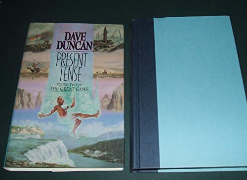
Present Tense: Round Two of the Great Game Duncan, Dave
Libro 2 di 3: The Great GameDa: Aragon Books Canada, OTTAWA, ON, Canada
Valutazione del venditore 3 su 5 stelle
EUR 30,55
Spedizione EUR 20,07
Spedito da Canada a U.S.A.Quantit�: 1 disponibili
Aggiungi al carrelloCondizione: New.
-
Tournament of Shadows: The Great Game and the Race for Empire in Central Asia Meyer, Karl E. and Brysac, Shareen Blair
Da: Aragon Books Canada, OTTAWA, ON, Canada
Valutazione del venditore 3 su 5 stelle
EUR 30,55
Spedizione EUR 20,07
Spedito da Canada a U.S.A.Quantit�: 1 disponibili
Aggiungi al carrelloCondizione: New.
-
An Act for the Better Protection of Occupiers of Land Against Injury to Their Crops from Ground Game [7th September 1880]
Lingua: Inglese
Editore: London, 1880
Prima edizione
EUR 11,81
Spedizione EUR 33,30
Spedito da Regno Unito a U.S.A.Quantit�: 1 disponibili
Aggiungi al carrelloString Sewn. Condizione: Vg-. First Edition. Light sunning to page edges. 4p.
-
King of the Khyber Rifles by Talbot Mundy. Classics Illustrated Issue #107. First printed c.1954.
Editore: Thorpe & Porter, London, 1954
Da: Cosmo Books, Shropshire., Regno Unito
Valutazione del venditore 5 su 5 stelle
EUR 19,23
Spedizione EUR 13,71
Spedito da Regno Unito a U.S.A.Quantit�: 1 disponibili
Aggiungi al carrelloComic Book. Condizione: Good. UK Edition. As it says on the cover, Classics Illustrated featured Stories by the World's Greatest Authors. See pictures for full details - the item you will receive is exactly the item shown in the three photos. 48 colour pages, with original printed covers. Condition as expected for an ephemeral comic. Dating C.I. comics precisely is rather hard, so we have given the first year of publication, and we have stated the HRN from the rear cover (where known) for the item which is a useful indicator. Please consult a decent bibliography or guide to the series to confirm details for yourself. Cover art by An Unidentified Artist. Story by Seymour Moskowitz. HRN #129. Size: 18 x 26 cms. Category: Comics & Graphic Novels; Classics Illustrated Comics; This item may require more postage than the rates shown for delivery outside the UK. If extra postage is required we will contact you before processing your order and you will be given the details and option to decline the extra cost. Cosmo Books : 29 years on ABE, 47 years taking care of customers. A bookseller you can rely on.
-
Kim by Rudyard Kipling. Classics Illustrated Issue #143. First printed c.1965.
Editore: Gilberton, New York, 1965
Da: Cosmo Books, Shropshire., Regno Unito
Valutazione del venditore 5 su 5 stelle
EUR 22,55
Spedizione EUR 13,71
Spedito da Regno Unito a U.S.A.Quantit�: 1 disponibili
Aggiungi al carrelloComic Book. Condizione: Good. US Edition. As it says on the cover, Classics Illustrated featured Stories by the World's Greatest Authors. See pictures for full details - the item you will receive is exactly the item shown in the three photos. 48 colour pages, with original printed covers. Condition as expected for an ephemeral comic. Dating C.I. comics precisely is rather hard, so we have given the first year of publication, and we have stated the HRN from the rear cover (where known) for the item which is a useful indicator. Please consult a decent bibliography or guide to the series to confirm details for yourself. Cover art by An Unidentified Artist. Story by An Unidentified Writer. HRN #167. Size: 18 x 26 cms. Category: Comics & Graphic Novels; Classics Illustrated Comics; This item may require more postage than the rates shown for delivery outside the UK. If extra postage is required we will contact you before processing your order and you will be given the details and option to decline the extra cost. Cosmo Books : 29 years on ABE, 47 years taking care of customers. A bookseller you can rely on.
-

Level Up!: The Guide to Great Video Game Design Rogers, Scott
Da: Aragon Books Canada, OTTAWA, ON, Canada
Valutazione del venditore 3 su 5 stelle
EUR 115,92
Spedizione EUR 20,07
Spedito da Canada a U.S.A.Quantit�: 1 disponibili
Aggiungi al carrelloCondizione: New.
-
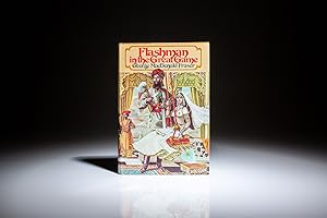
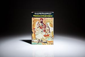
Flashman in the Great Game; From the Flashman Papers 1856-58
Da: The First Edition Rare Books, LLC, Cincinnati, OH, U.S.A.
Membro dell'associazione: ABAA ILAB IOBA MWABA
Valutazione del venditore 5 su 5 stelle
Prima edizione
Cloth. Condizione: Fine. Condizione sovraccoperta: fine. First American edition of Flashman in the Great Game by George MacDonald Fraser, the fifth novel in the Flashman series. (illustratore). First American Edition. Octavo, 340pp. Yellow cloth spine, title stamped in red on spine. Top edge dyed red. First edition statement on copyright page. Solid and clean text block, a fine example. In the publisher's fine dust jacket, $8.95 retail price on front flap, a bright example. George MacDonald Fraser (1925-2008) based the idea of Flashman on the original character created by Thomas Hughes in Tom Brown's School Days, published in 1857. The Flashman character was a fictionalized look at the 19th century British Army, but Fraser was always praised for his historical accuracy in portraying real world events. By the time of his death in 2008, Fraser published twelve Flashman novels, including: Flashman (1969), Royal Flash (1970), Flash for Freedom! (1971), Flashman at the Charge (1973), Flashman in the Great Game (1975), Flashman's Lady (1977), Flashman and the Redskins (1982), Flashman and the Dragon (1985), Flashman and the Mountain of Light (1990), Flashman and the Angel of the Lord (1994), Flashman and the Tiger (1999) and Flashman on the March (2005).
-
Geographical Results of the Tibet Mission.
Editore: Smithsonian Institution, (Washington)., 1905
Da: Asia Bookroom ANZAAB/ILAB, Canberra, ACT, Australia
Membro dell'associazione: ANZAAB ILAB
Valutazione del venditore 5 su 5 stelle
EUR 47,19
Spedizione EUR 18,54
Spedito da Australia a U.S.A.Quantit�: 1 disponibili
Aggiungi al carrelloDisbound report (from the Annual Report for the Smithsonian Institution): pp 265-277, 8 black and white photographic plates, 22.5 x 14.7 cms, front leaf loose, age-toning and inner edge a trifle marked but otherwise in very good condition. Sir Francis Younghusband (1863-1942) returned to a hero's welcome following his Tibet "Expedition" of 1903-4, which was, in reality a militarized diplomatic mission driven by geopolitical anxiety (the Great Game) and was marked by dramatic clashes and some 2,700 Tibetan casualties. This report was originally read at the Royal Geographical Society in London in February 1905 (here reprinted from a Smithsonian Annual Report of the same year) and was widely reviewed. One such appearing in "Nature" belied the military truths: "[Younghusband] was also able to touch briefly upon some of the results obtained by the scientific experts who accompanied the mission, as well as by the survey party under Captains Rawling and Ryder, which in the late autumn did excellent work along the whole course of the Upper Brahmaputra, proving definitely that no peaks higher than Everest exist on this flank of the Himalayas.".
-
Flashman in the Great Game; From the Flashman Papers 1856-58
Editore: Barrie & Jenkins, London, 1975
Da: The First Edition Rare Books, LLC, Cincinnati, OH, U.S.A.
Membro dell'associazione: ABAA ILAB IOBA MWABA
Valutazione del venditore 5 su 5 stelle
Prima edizione
Cloth. Condizione: Near fine. Condizione sovraccoperta: very good. First edition of Flashman in the Great Game by George MacDonald Fraser, the fifth novel in the Flashman series. (illustratore). First Edition. Octavo, 336pp. Red cloth, title stamped in silver on spine. First edition statement on copyright page. Solid and clean text block, a fine example. In the publisher's dust jacket, retail price on front flap, chip to top edge of rear panel, toning to spine, a bright example. George MacDonald Fraser (1925-2008) based the idea of Flashman on the original character created by Thomas Hughes in Tom Brown's School Days, published in 1857. The Flashman character was a fictionalized look at the 19th century British Army, but Fraser was always praised for his historical accuracy in portraying real world events. By the time of his death in 2008, Fraser published twelve Flashman novels, including: Flashman (1969), Royal Flash (1970), Flash for Freedom! (1971), Flashman at the Charge (1973), Flashman in the Great Game (1975), Flashman's Lady (1977), Flashman and the Redskins (1982), Flashman and the Dragon (1985), Flashman and the Mountain of Light (1990), Flashman and the Angel of the Lord (1994), Flashman and the Tiger (1999) and Flashman on the March (2005).
-
The Kafirs of the Hindu-Kush.
Editore: Lawrence & Bullen Ltd., London., 1896
Da: Asia Bookroom ANZAAB/ILAB, Canberra, ACT, Australia
Membro dell'associazione: ANZAAB ILAB
Valutazione del venditore 5 su 5 stelle
EUR 613,46
Spedizione EUR 18,54
Spedito da Australia a U.S.A.Quantit�: 1 disponibili
Aggiungi al carrelloNew Edition. Coloured folding map (tipped in at rear), 79 full page and text illustrations by A. D. McCormick, xx + 658pp, original decorated polished red cloth, spine gilt-lettered, 24 x 15.5 cms, front free endpaper browned, neat inscription of a previous owner to the front pastedown, manuscript short index tipped in by a previous owner at rear, boards bumped and stained and spine a little sunned, but a good complete copy. A distinguished soldier, diplomat and Anglo-Indian administrator, Sir George Scott Robertson (1852?1916), journeyed in Kafiristan in 1890-91 living for a year among the "wild" hillmen. The Kafirs? polytheistic religion and customs were rapidly disappearing by the time Robertson visited and his work served as one of the most important eyewitness accounts of the pre-Islamic cultures of the Hindu Kush and as valuable historical record of a culture that was quickly being assimilated into the broader Afghan Islamic state. It is one of the last detailed accounts of the Kafir people before they were forced into Islam or eradicated by Afghan forces. Robertson?s book also provides important historical context for understanding the political dynamics of the Great Game. His observations of the Kafirs? resistance to the Afghan Amir and his concerns about the potential spread of Islam in the region highlight the intersection of politics, culture, and religion in Central Asia during the 19th century. The profuse illustrations, are after sketches and watercolours by Arthur David McCormick who was artist on Sir Martin Conway's expedition to the Karakoram subrange of the Himalayas and in 1895 on Clinton T. Dent's expedition to the Caucasus Mountains.
-

Bokhara, Afghanistan, Beloochistan, &c.
Editore: (Society for the Diffusion of Useful Knowledge); Charles Knight, London., 1852
Da: Asia Bookroom ANZAAB/ILAB, Canberra, ACT, Australia
Membro dell'associazione: ANZAAB ILAB
Valutazione del venditore 5 su 5 stelle
EUR 78,65
Spedizione EUR 18,54
Spedito da Australia a U.S.A.Quantit�: 1 disponibili
Aggiungi al carrelloEngraved map, 39 x 30.5 cms; 41 x 34 cms (sheet), relief throughout shown by hachures, publisher's or binder's numeric stamp (94A), the margins a little browned and chipped with loss to the two keys at the inner edge marking Indian and Persian distances but the map in very good condition. A highly detailed example of political and military cartography from the height of the Victorian era, capturing the Central Asian frontier at the dawn of the "Great Game". The map covers the expanse of Central Asia, stretching from the deserts of modern-day Uzbekistan and Turkmenistan down through Afghanistan and Pakistan to the Arabian Sea. It maps out the Emirate of Bukhara in the north and the Desert of Khiva. It explicitly references the "Nomadic Tribes of Turkomans" roaming the steppes. Afghanistan is centred on the map, and displays the fractured geography of the Afghan kingdom. It details the treacherous mountain passes of the Hindu Kush, alongside the major strategic cities of Kabul, Kandahar, and Herat. Beloochistan (Balochistan) & Sinde (Sindh)anchor the southern third of the sheet, it routes down toward the coastline, showing the vast desert paths, tribal domains, and the mouth of the Indus River.
-
Collection of autograph letters and manuscript material concerning moves during the First Anglo-Afghan War.
Editore: Kabul and elsewhere: 1837-41 & 1859, 1859
Da: Peter Harrington. ABA/ ILAB., London, Regno Unito
Membro dell'associazione: ABA ILAB PBFA
Valutazione del venditore 5 su 5 stelle
EUR 11.274,57
Spedizione EUR 25,35
Spedito da Regno Unito a U.S.A.Quantit�: 1 disponibili
Aggiungi al carrelloA carefully assembled collection of material connected to players in the "great game", including Colonel Stoddart and Captain Arthur Conolly, both famously beheaded at Bukhara, Major Henry Rawlinson, the political agent at Kandahar, and Captain Sir Alexander "Bukhara" Burns. The material, mounted on album leaves with accompanying newspaper clippings and other ephemera, is tied together by Connolly and Stoddart's dramatic death. Sent on a mission to secure an agreement of friendship between Britain and the Emir of Bukhara, in 1838 Stoddart was arrested by the emir on charges of spying and imprisoned. Conolly, the intelligence agent credited with coining the term "great game" in an 1840 letter to Rawlinson, arrived in Bukhara in late 1841 to negotiate his compatriot's release. Both men were killed in June 1842 and became household names back home. In the first two letters, Burns, writing about a year before he was killed by a mob in Kabul, shares his views with Rawlinson on the latest moves in the "great game". He writes of Stoddart's (short-lived) release from prison and of the importance of Conolly's current intelligence-gathering in Central Asia. Shah Shuja "is surrounded by a parcel of harpies", and Burns advises caution about the use of British troops to prop up the Shah's rule: "Nothing contributes so much to lower the King's power as the employment of our troops against Afghans & I would avoid it if possible." As for Lord Auckland, the governor-general "does not have great faith in the sincerity of Russia in abandoning her Khiva designs but it gives us time." The third letter, from Conolly to Rawlinson, discusses local news and offers a lighter-hearted window onto the life of a political agent far from home. He has swapped the diplomatic chessboard for the card table: "We miss you very much - especially at whist", the previous night's rubber being "stale and flat, but not unprofitable, for I won 9 rupees." This letter is mounted with a page of Stoddart's notes on taking navigational bearings, which Stoddart gave to Rawlinson before departing for Central Asia in 1837. The final piece touches on the wider appeal of the Stoddart-Conolly story. Writing to the Cornish baronet Sir Hugh Molesworth almost two decades later, Dr Joseph Wolff mentions his second expedition to Bokhara, mounted to ascertain the fate of the two men, and how the profits from the two editions of his best-selling Narrative of a mission to Bokhara (1845) were sufficient to finance a parsonage and schoolhouse in his living. a) Sir Alexander Burns to Major Henry Rawlinson, 21 December 1840, Kabul. ALS, bifolium, written across all sides. b) Sir Alexander Burns to Major Henry Rawlinson, 20 January 1841, Kabul. ALS, bifolium, written across all sides. c) Captain Arthur Conolly to Major Henry Rawlinson, 1840, Kabul. ALS, bifolium and single sheet, written across 5 sides, addressed on final side, remains of wax seal. d) Colonel Stoddart's autograph notes on taking navigational bearings, single sheet, written one side. Endorsed on verso by Rawlinson, "Given to me by Col. Stoddart on his departure for Bokhara in 1837. H. Rawlinson"; later note to the same effect, but in a different hand, below. e) Revd Dr Joseph Wolff to Revd Sir Hugh H. Molesworth, 31 August 1859, Taunton, Somerset. ALS, bifolium, written across 3 sides. 4 autograph letters and single sheet of notes, totalling 17 sides of manuscript, tipped to or mounted on stubs to card album leaves (370 x 265 mm), with laid-down material (11 newspaper clippings, 2 printed illustrations, sheet of manuscript), later brief captions in manuscript. Letters and sheet of notes generally well preserved, staining and creasing as expected, stubs occasionally just touching text but no loss to sense: a very good collection.
-
Large military wall map of Central Asia and the Turkestan Military District, revised and corrected up to 1881.
Editore: St Petersburg: Cartographic Institute of the Military-Topographic Department of the General Staff, 1881, 1881
Da: Peter Harrington. ABA/ ILAB., London, Regno Unito
Membro dell'associazione: ABA ILAB PBFA
Valutazione del venditore 5 su 5 stelle
EUR 20.768,95
Spedizione EUR 25,35
Spedito da Regno Unito a U.S.A.Quantit�: 1 disponibili
Aggiungi al carrelloSecond edition, significantly improved from the first edition (1877) to incorporate the latest military intelligence from field surveys. This magisterial work of "great game" cartography was presented at Russia's Tashkent military headquarters to the daring French explorer Stanislas Benoist-M�chin, during his epic 1881-3 overland journey from Beijing to Europe. We have traced no other copies. A presentation inscription on the verso of the map reads, in French, "To Mr Baron Benoist-M�chin, from Generals Kouropatkine and Levaschew, October 1882, Tashkent." Benoist-M�chin (1854-1923) began travelling the world as a young man and then served as the French cultural attach� in Tokyo, 1880-1. In 1881, he decided to return to Europe via the daring route through Central Asia. Leaving Beijing on 15 September with his regular travelling companion, Comte Humbert Adrien de Mailly-Chalon (1853-1921), he journeyed through Manchuria and across Russian Siberia. In 1882, having reached Kashgar, they received permission to cross Russian Turkestan, spending six weeks in Tashkent as the honoured guests of General Mikhail Tchernayev, the architect of Russian's expansion across Central Asia, General Aleksey Nikolayevich Kuropatkin (1848-1925), and the aforementioned General Levaschov (likely the artillery officer Vladimir Levaschov, 1834-1898). After reaching Samarkand, they travelled in extreme cold through Bukhara and via Khiva to Tehran, reaching Moscow in October 1883, where they were accorded a hero's welcome. Their descriptions of this feat of exploration were published in 1885 in the Bulletin de la Soci�t� de g�ographie. This map was made for the use of the Russian military high command in St Petersburg and in the Turkestan Military District, which had been established in the 1860s amid the occupation of Tashkent and Bokhara, and dates from a period (following the Second Anglo-Afghan War and the Battle of Geok Tepe) when tensions were at their height. It encompasses almost the entire playing surface of the "great game", extending east-west from Xinjiang and Tibet to the Caspian Sea and Afghanistan and north-south from Siberia to northern India. Unparalleled in terms of accuracy and detail, it names every city, town, and village, and the legend has entries for such features as fortifications, railways, mail and caravan roads, and mines. Spot heights are given in feet, and deserts are marked with a light red pattern. It is much improved on the first edition, which had only 48 panels and did not extend as far south. Chromolithograph map (195 x 200 cm), dissected onto 64 sections and mounted on linen as issued, laid-down printed slip stating "corrected up to 1881", small folding tab at right edge. Folding away to 28.5 x 28 cm. Housed in green quarter morocco solander box with chemise by the Chelsea Bindery. Map surface generally clean and bright,a few stains, toning and soiling at edges, small repair at top-left edge, verso foxed and with couple of areas of linen reinforcement: very good.
-

Politisch-militarische Karte von Afghanistan, Persien und Vorder-Indien : zur Veranschaulichung des Vordringens der Russen und Englander.
Data di pubblicazione: 1900
Da: Geographicus Rare Antique Maps, Brooklyn, NY, U.S.A.
Membro dell'associazione: ABAA ESA ILAB
Valutazione del venditore 4 su 5 stelle

Mappa
Hardcover. Very good. Folds into its original paper boards, to which it remains attached. Size 29.25 x 25 Inches. An intriguing c. 1900 by Paul Langhans map of Central and South Asia, focusing on Afghanistan. It coincided with the last stage of the 'Great Game' competition between Russia and Great Britain, whose military forces throughout the region are meticulously cataloged. A Closer Look This map covers from the southern Russian Empire to Sri Lanka, focusing on Persia and Afghanistan. Territories (empires, emirates, khanates, Indian Princely States) are color-shaded and clarified in the legend at bottom-right, though the borders and exact sovereignty over some was not so clear cut, especially in the mountainous regions (Himalayas and Pamirs) where imperial claims butted up against one another. Throughout, the location of fortifications and troops are recorded in detail. Roads and railways of military significance are traced in red, while telegraph lines are traced in blue. Red overprint adds explanation and records areas of military significance not immediately relevant from the map itself, such as the summer capital of the British Raj at Simla and the maritime routes and ports that could be used for troop transport. Famine areas ( hungergebiete ) are also noted; there were, unfortunately, many of these in the late 19th century, particularly in western India, generally owing to drought caused by the failure of summer monsoons. Three inset maps appear: a large one at bottom-left that focuses more closely on Afghanistan and records troops and fortifications, including those of the Emirate of Afghanistan, noting, in particular, the British military campaigns against the border tribes of North-West India in 1895 - 1898; a smaller inset at top-right displaying Eurasia with major railways, telegraph lines, and the year of imperial acquisition of various territories noted; and a smaller inset below that displaying southwestern Germany at the same scale as the main map for comparison. The End of the 'Great Game' 'The Great Game' was a diplomatic confrontation between the British and Russian Empires over Afghanistan and other territories in Central and Southern Asia. There is considerable debate as to when the Great Game began, but it was most likely the 1813 Treaty of Gulistan between Russia and Persia, which ended the Russo-Persian War (1804 - 1813), opened Persia to further Russian intervention and set Russian and British regional interests at odds. The conflict, related to wider animosity between Russia and Britain, revolved around Afghanistan, which, while lacking significant resources of its own, was strategically situated. For its part, Russia feared Britain was making commercial and military inroads into Central Asia, an area increasingly coming under the control of St. Petersburg. Britain, conversely, feared Russia intended to challenge its predominance in India, 'the jewel in the crown' of British Asia. The escalating tensions led to several wars and proxy wars: The First Anglo-Afghan War (1839 - 1842), the First Anglo-Sikh War (1845 - 1846), the Second Anglo-Sikh War (1848 - 1849), and the Second Anglo-Afghan War (1878 - 1880), along with the Russian annexations of Khiva, Bukhara, and Kokand. Then, as now, Afghanistan proved a grinding stone upon which the world's great empires diminished themselves, none achieving a definitive victory despite committing staggering resources. Regarding the attitude of Afghans toward the British and Russians, the general assumption of the British was that 'Some will fight for us, some against us, but all will fight.' The Great Game 'ended' on September 10, 1895, with the signing of the Pamir Boundary Commission Protocols, which stabilized the border between Afghanistan and the Russian Empire. Although the British maintained significant influence in the foreign policy decisions of the Emirate of Afghanistan, the country's internal affairs remained exactly that (at this time, the amir Abdur Rahman Khan.
-
Three maps: Persia, Afghanistan, and Turkey in Asia.
Editore: Dehra D�n, India, & Berlin: Photozincographed at the Office of the Trigonometrical Branch, Survey of India, & Dietrich Reimer, 1899-1904, 1904
Da: Peter Harrington. ABA/ ILAB., London, Regno Unito
Membro dell'associazione: ABA ILAB PBFA
Valutazione del venditore 5 su 5 stelle
EUR 17.801,96
Spedizione EUR 25,35
Spedito da Regno Unito a U.S.A.Quantit�: 1 disponibili
Aggiungi al carrelloA rare opportunity to acquire three exceptionally impressive and uncommon maps, together forming the finest contemporary cartographic overview of the Great Game's central theatre. Spanning from the Mediterranean to Afghanistan and from the Caspian to Sir Baniyas Island, they present a striking synoptic view of the region at a moment of intense strategic interest. All three share the same provenance, each bearing the distinguished bookplate of the officers' mess library of the 85th Foot, later part of The King's Light Infantry. Likely acquired as a group by an officer attuned to imperial affairs in the run-up to, or immediate aftermath of, the 1907 Anglo-Russian Convention, they reflect the period's effort, as Hopkirk notes, to resolve regional rivalries and curb Germany's eastward ambitions. The Persia map is a landmark Survey of India production and the most comprehensive rendering of the region then available, incorporating the latest British and Russian surveys and reconnoitres. Only 300 copies of this August 1904 issue were printed, and institutional locations are limited to the British Library, Deutsche Nationalbibliothek, and S�chsische Landesbibliothek. The impressive wall map of Afghanistan (June 1901), produced under Strahan and Gore and executed at the Frontier Drawing Office under Colonel R. A. Wahab, is equally rare, with copies recorded only at the British Library, Wisconsin, and the Bayerische Staatsbibliothek. Its authority rests on extensive British and Russian sources, including work by Robertson, Trotter, Sykes, Ney Elias, and the Afghan Boundary Commission. These maps exemplify the Survey of India's exacting standards during the era of photozincographic production, when officers were required to vet every detail under magnification. Kiepert's map of the Ottoman Empire complements the two Survey of India sheets, representing the best contemporary mapping of a region Britain could not itself survey. Kiepert, one of the foremost scholarly cartographers of the 19th century, travelled widely in Ottoman territories, producing clear and remarkably accurate maps that remain valuable records of the period. This map is comparatively well represented institutionally, with around 17 holdings recorded in Europe, the US, and the UK. Kourosh Ahmadi, Islands and International Politics in the Persian Gulf: Abu Musa and the Tunbs in Strategic Perspective, 2008; Kyle J. Gardner, The Frontier Complex: Geopolitics and the Making of the Indo-China Border, 1846-1962, 2021; Peter Hopkirk, The Great Game: On Secret Service in High Asia, 1992. Persia: scale 1:1,013,760, six-sheet coloured map divided into four linen-backed quadrants, each measuring approx. 976 x 963 mm, when assembled measuring 1952 x 1926 mm (North West, North East, South West, South East), each backed with Nonpareil pattern marbled paper, each section dissected into 20; Afghanistan: scale 1:1,013,760, coloured map dissected into 45 sections, linen backed, measuring approx. 1035 x 1640 mm; Turkey: scale 1:1,500,000, coloured map dissected into 65 sections, linen backed, measuring approx. 1016 x 1700 mm; together with the "Apercu general", measuring 412 x 570 mm, showing the administrative division of the same area, intended to accompany the map; dissected into 10 sections, linen backed. Each map housed in the original dull purple morocco-grain cloth case, Stanford's printed label to front. Cases a little worn with some loss of fabric, light toning to maps otherwise in excellent condition. Cases a little worn with some loss of fabric, occasional light toning to maps, otherwise in excellent condition.
-

Notice of Conviction for Poaching, Leek, Staffordshire, UK, 1874
Data di pubblicazione: 1874
Da: The Lawbook Exchange, Ltd., ABAA ILAB, Clark, NJ, U.S.A.
Membro dell'associazione: ABAA ESA ILAB
Valutazione del venditore 5 su 5 stelle
Convicted for Poaching Trout [Game Law]. [Great Britain]. [Notice of Conviction for Poaching, Leek, Staffordshire, England, June 8, 1874]. 13-1/4" x 8-3/4" (33.65 x 22.22 cm) single sheet, part-printed document on blue paper completed in manuscript, wax seals at foot next to signatures. Horizontal fold line to center, two minor creases to lower right corner. $150. * Benjamin Alcock was convicted for poaching trout in a private stream owned by Richard Roscoe. The court at Leek gave him a fine of five shillings plus costs of one pound and sixpence. Alcock was further charged that he would be "imprisoned in the House of Correction at Stafford and (.) kept to hard labour for the space of seven days" if he failed to pay his fine.
-

Historically Significant Collection of Fourteen Original Albumen Photos, Likely Taken by a Professional Russian Photographer in Mashhad, Iran, in the Late 1890s, Showing Imam Reza Holy Shrine before the 1912 Bombardment, Gawhar-Shad Mosque, British Consulate, Iranian Artillery Barracks, Governor's Palace, Russian & Cossack Forces, etc.; also, with the Photos of "Tehran" and "New Afghan Gate". Ca. 1890s.
Data di pubblicazione: 1890
Da: Globus Rare Books & Archives, San Francisco, CA, U.S.A.
Membro dell'associazione: ABAA ILAB
Valutazione del venditore 5 su 5 stelle
None. Condizione: None. Fourteen loose original albumen photographs ca. 17,1x12,3 cm (6 � x 4 � in) mounted on ornamented cardboards. All photos with period Russian captions on the verso. Photos housed in a folder. Light soiling of the cardboards, photos age-toned, several photographs with small stains, but overall a very good collection of strong, interesting photos. Historically important collection of professional albumen photographs, mostly documenting Mashhad, Iran, in the late 19th century and before the 1912 bombardment of the city. At the time, Mashhad was a major political and commercial center under the Qajar dynasty. Owing to its proximity to Afghanistan and Russian Central Asia, the city became a focal point of the Great Game between Britain and Russia. Following the establishment of the Russian consulate in Mashhad (1889), Russian consular guards, Cossack escorts, and military advisers appeared in the city to protect Russian subjects. In 1912, amid anti-Russian protests, Russian Cossack forces heavily bombarded the city, heavily damaging the Imam Reza Holy shrine complex and surrounding areas. As follows from the captions, the photographer was of Russian origin and was likely on assignment related to the military interests of the empire in the region. The stiff ornamental mounts suggest that the photos were produced for official or presentation purposes, possibly intended for consular archives, a government report, or as a gift to a high-ranking official. The collection contains 14 photographs of mostly Mashhad, including four well-executed early views of the pre-bombarded Imam Reza Holy Shrine. The images show a general view of the crowded shrine, the arch and courtyard with horses, and an archway guarded by armed soldiers. Another important photo depicts the interior of the nearby Gawhar-Shad Mosque with three Russian soldiers posing on the pulpit. Especially interesting is an image of the British Consulate entrance, established in the city in 1889 (The consulate was closed in 1911 following the Anglo-Russian Convention of 1907, which divided Persia into spheres of influence). Despite thorough research, no other photographs of the consulate have been found online. Other identified photographs from Mashhad include the Persian artillery barracks with cannons in the yard, and the entrance to the governor's palace, showing a dozen militaries and civilians posing for the photo. The collection also includes at least two photographs from Afghanistan, depicting the crowded "Tehran Gate" with locals in traditional attire passing through, and the "New Afghan Gate," with armed soldiers facing the camera. Among four unidentified photographs are "Igda" (possibly "Eedgah," Kandahar, Aghanistan), "Kochan" (possibly Kashan, Iran), the "Ergov" gates, and the "Bank Gates," with Kazak soldiers guarding the entrance. Overall, historically important collection of professional albumen photographs, mostly documenting Mashhad, Iran, in the late 19th century and before the 1912 bombardment of the city.
-
Turkestan and the countries between the British and the Russian Dominions in Asia.
Data di pubblicazione: 1879
Da: Geographicus Rare Antique Maps, Brooklyn, NY, U.S.A.
Membro dell'associazione: ABAA ESA ILAB
Valutazione del venditore 4 su 5 stelle
Mappa
Good. Some wear and loss along fold lines and at fold intersections. Size 59 x 80 Inches. This is a fascinating 1879 map of Central Asia, divided into four large folding sheets, produced by G.W.E. Atkinson, a British Survey of India expert on Tibet, the Himalayas, and Central Asia. It was produced at the height of the 'Great Game' and intended for use by the government and military of British India. This map provides unique insight into the collaborative process of Russian and British surveyors operating in Central Asia despite ongoing political conflict. A Closer Look The map is divided into four sheets, each roughly 29 x 40 inches: the first (top-left) includes the Caspian and Aral Seas and takes in Khiva, Bukhara, and Samarkand in the western part of modern Kazakhstan and Uzbekistan; the second (top-right) includes Lake Balkhash, the Tianshan mountains, and the western part of Eastern Turkestan (also known as Chinese Turkestan or Xinjiang), taking in Turkestan (Turkistan), Kuldja (Ghulja), Jizzakh, and the settlements in the western parts of the Tarim Basin (Kashgar, Yarkand, Aksu, and Kuchar); the third (bottom-left) covers much of Persia and the western half of Afghanistan as well as part of Baluchistan; and the fourth (bottom-right) ranges from the eastern half of Afghanistan, through the northern portion of British India, the Hindu Kush and Pamir Mountains, and to the western part of the Himalayas and Tibet. Sources - An Imperial Exchange The number of sources drawn on attest to the importance of the accuracy of this map. In particular, the Survey of India used Russian [Army] Topographical Department maps to compile their own maps, and the Russians likewise used British maps to improve theirs. In fact, despite the competition between the imperial superpowers, cartographers and explorers from both sides were quite ready to exchange information, motivated by a shared interest in improving geographical knowledge. Accurate geographical knowledge was an important factor in preventing a wider conflict. A series of agreements between the Russians and British beginning in 1873 defined the region's borders and helped develop a buffer zone between British and Russian spheres. But - Back to Conflict Still, Russian expansion and British finagling of local rulers made for rapid territorial changes. Also, at this time, Qing China had just reconquered Eastern Turkestan (Xinjiang) after a series of large revolts, and in the following decades, would seek to dissuade British and Russian adventurism in Xinjiang and Tibet. Russia's Conquest of Central Asia Russian contacts with Central Asia predated this map by many centuries, and Russian national identity is largely rooted in the relationship with the steppe and interaction (trade, warfare, etc.) with steppe-dwelling peoples. In the 17th and 18th centuries, the Russian Empire established a series of border forts that roughly followed the edge of the forested land before reaching the steppe, concurrent with the present-day border between the Russian Federation and Kazakhstan. Occasional forays into the steppes were attempted, but conquering those territories in any meaningful sense remained elusive. Using the latest military, communication, and transportation technology, the Russian Empire focused intently in the mid-19th century on subjugating Central Asia. Although the region had lost some of its wealth and luster from the height of the Silk Road, it was still home to powerful states that held their own in skirmishes with neighboring empires in the 18th and early 19th centuries. The Russians encountered difficulties controlling the region, starting with a disastrous 1839 attack on Khiva. (Khiva was eventually conquered in 1873). Rather than military strategy or technology, the main obstacle for the Russians was supplying troops so far from the Russian heartland in a region with minimal infrastructure. Getting supplies to the main staging area at Orenburg was difficult enough, but then th.
-
Da: Patrick Pollak Rare Books ABA ILAB, SOUTH BRENT, DEVON, Regno Unito
Membro dell'associazione: ABA ILAB
Valutazione del venditore 3 su 5 stelle
EUR 59,34
Spedizione EUR 28,81
Spedito da Regno Unito a U.S.A.Quantit�: 1 disponibili
Aggiungi al carrellopp. [681]-686. In excellent condition, disbound from the annual volume with the stitching retained.
-
The influences of the game laws; being classified extracts from the evidence taken before a Select committee of the House of commons on the game laws, and some introductory remarks 1846 [Leather Bound]
Data di pubblicazione: 2024
Da: Gyan Books Pvt. Ltd., Delhi, India
Valutazione del venditore 5 su 5 stelle
EUR 45,24
Spedizione gratuita
Spedito da India a U.S.A.Quantit�: Pi� di 20 disponibili
Aggiungi al carrelloLeather Bound. Condizione: New. Language: English. Language: English. Presenting an Exquisite Leather-Bound Edition, expertly crafted with Original Natural Leather that gracefully adorns the spine and corners. The allure continues with Golden Leaf Printing that adds a touch of elegance, while Hand Embossing on the rounded spine lends an artistic flair. This masterpiece has been meticulously reprinted in 2024, utilizing the invaluable guidance of the original edition published many years ago in 1846. The contents of this book are presented in classic black and white. Its durability is ensured through a meticulous sewing binding technique, enhancing its longevity. Imprinted on top-tier quality paper. A team of professionals has expertly processed each page, delicately preserving its content without alteration. Due to the vintage nature of these books, every page has been manually restored for legibility. However, in certain instances, occasional blurriness, missing segments, or faint black spots might persist. We sincerely hope for your understanding of the challenges we faced with these books. Recognizing their significance for readers seeking insight into our historical treasure, we've diligently restored and reissued them. Our intention is to offer this valuable resource once again. We eagerly await your feedback, hoping that you'll find it appealing and will generously share your thoughts and recommendations. Lang: - English, Pages: - 522, Print on Demand. If it is a multi-volume set, then it is only a single volume. We are specialised in Customisation of books, if you wish to opt different color leather binding, you may contact us. This service is chargeable. Product Disclaimer: Kindly be informed that, owing to the inherent nature of leather as a natural material, minor discolorations or textural variations may be perceptible. Explore the FOLIO EDITION (12x19 Inches): Available Upon Request. 522 522.


![Immagine del venditore per The influences of the game laws; being classified extracts from the evidence taken before a Select committee of the House of commons on the game laws, and some introductory remarks 1846 [Leather Bound] venduto da Gyan Books Pvt. Ltd.](https://pictures.abebooks.com/inventory/md/md31434339445.jpg)