Importo totale (1 articolo articoli):
Destinazione ordine:

new york map (195 risultati)
Vai alla pagina principale dei risultati di ricerca
Filtri di ricerca
Tipo di articolo
- Tutti i tipi di prodotto
- Libri (39)
- Riviste e Giornali (Nessun altro risultato corrispondente a questo perfezionamento)
- Fumetti (Nessun altro risultato corrispondente a questo perfezionamento)
- Spartiti (Nessun altro risultato corrispondente a questo perfezionamento)
- Arte, Stampe e Poster (Nessun altro risultato corrispondente a questo perfezionamento)
- Fotografie (Nessun altro risultato corrispondente a questo perfezionamento)
- Mappe (156)
- Manoscritti e Collezionismo cartaceo (Nessun altro risultato corrispondente a questo perfezionamento)
Condizioni Maggiori informazioni
- Nuovo (12)
- Come nuovo, Ottimo o Quasi ottimo (Nessun altro risultato corrispondente a questo perfezionamento)
- Molto buono o Buono (11)
- Discreto o Mediocre (3)
- Come descritto (169)
Legatura
Ulteriori caratteristiche
Lingua (2)
Spedizione gratuita
Paese del venditore
Valutazione venditore
-

Vacationists Directory To The Central Adirondacks
Da: Terrace Horticultural Books, St. Paul, MN, U.S.A.
Membro dell'associazione: ABAA ILAB
Valutazione del venditore 4 su 5 stelle

StapleBound. Condizione: very good. Green Tint Photo, Map (illustratore). Narrow 12mo, No Date, Ca 1950, PP.18, Hotels, Cottages, Camps, Restaraunts, Services, TRansportation, Stables etc.Along Route 28, The Adirondack Lakes Trais.
-
Guia Comercial
Editore: National City Bank of New York, New York, 1920
Da: Vashon Island Books, Vashon, WA, U.S.A.
Valutazione del venditore 5 su 5 stelle

Copia autografata
Flexible Leather. Condizione: Very Good-. No Jacket. b/w Illustration + Map (illustratore). First Thus. 8vo - over 7�" - 9�" tall. in flexible black leather with gilt titling and seal to cover; decorative floral patterned endpapers, minor edges wear and rubbing, spine tips with light chipping, A commercial guide for the National City Bank of New York for the year 1920 in spanish and english; 8vo, 661pp. inscribed and signed by James h. Roth "American vice consul in charge, American Consulate General, Lima, Peru June 23, 1920".
-

"THIS IS THE HOUR WHEN WE MUST THROW INTO BATTLE THE LAST LITTLE OUNCE OF STRENGTH" -MAP 8-20-44
Editore: THE NEW YORK TIMES, 1944
Mappa Prima edizione
No Binding. Condizione: Fair. 1st Edition. "THIS IS THE HOUR WHEN WE MUST THROW INTO BATTLE THE LAST LITTLE OUNCE OF STRENGTH" GERMAN BROADCAST QUOTE. ORIGINAL MAP CLIPPING FROM THE NEW YORK TIMES 8-20-1944. MANDITCH MAP CARTOGRAPHER. PAPER IS TANNED AND FRAGILE.
-
COMMERCIAL TRAVELERS' and TOURISTS AUTO MAP of MAINE showing Railway Systems, Distances, Interurban Trolleys, Leading Industries and Indexed Location of Towns, Junction Points. Population per 1920 Census. Directory of Commercial Hotels, Rates. 1923-1924 Edition
Editore: Blum's Commercial Map Pub. Co, New York, 1923
Da: Peter L. Masi - books, MONTAGUE, MA, U.S.A.
Membro dell'associazione: SNEAB
Valutazione del venditore 4 su 5 stelle
Folding Map. Condizione: Collectible. 7 pages. 13.5 x 9.5" map. 6.75 x 4.75", printed wrapper. VG.
-
BLUM'S COMMERCIAL TRAVELERS' MAP of MASSACHUSETTS, Showing Railway Systems, Railway Distances, Interurban Trolleys, Leading Industries and Indexed Location of all towns having a population of 1000 or more, Commercial Hotels, Rates, &c. 1919-1920 Edition
Editore: Blum's Commercial Map Publishing Company, New York, 1919
Da: Peter L. Masi - books, MONTAGUE, MA, U.S.A.
Membro dell'associazione: SNEAB
Valutazione del venditore 4 su 5 stelle
Pamphlet. Condizione: Used - Very Good. 9.5 x 13.5" folding map by Max L. Blum. 6.75 x 4.75", printed wrapper. Wrap soiled, VG.
-
BLUM'S COMMERCIAL TRAVELERS' MAP of CONNECTICUT and RHODE ISLAND, Showing Railway Systems, Railway Distances, Interurban Trolleys, Leading Industries and Indexed Location of all towns having a population of 1000 or more, Commercial Hotels, Rates, &c. 1920-1921 Edition
Editore: Blum's Commercial Map Publishing Company, New York, 1920
Da: Peter L. Masi - books, MONTAGUE, MA, U.S.A.
Membro dell'associazione: SNEAB
Valutazione del venditore 4 su 5 stelle
Pamphlet. Condizione: Used - Very Good. 9.5 x 13.5" folding map by Max L. Blum. 6.75 x 4.75", printed wrapper. VG.
-
New York Botanical Garden Bronx Park Descriptive Guide To The Grounds, Buildings, And Collections
Data di pubblicazione: 1920
Da: Terrace Horticultural Books, St. Paul, MN, U.S.A.
Membro dell'associazione: ABAA ILAB
Valutazione del venditore 4 su 5 stelle
Hardcover. Condizione: Very Good. B & W Photos, Map (illustratore). Copyright Date: 1920 Octavo, Paper Card Boards, Cloth Spine, Hardcover, PP.212 Plus Fold Out Map, Light Soil And Wear At Extremities.
-
Alfred University Hand Book 1836 - 1931
Editore: Alfred University, New York [ca. 1931]
Da: Vashon Island Books, Vashon, WA, U.S.A.
Valutazione del venditore 5 su 5 stelle
Prima edizione
Paperback. Condizione: Very Good. B/w Fold Out Map (illustratore). First Thus. VG in wraps; minimal wear to spine; pamphlet 12mo., 33pp + folding map of the campus. Size: 12mo - over 6�" - 7�" tall. Book.
-
The Official Maps of New York
Editore: Chester, Vermont. The National Survey Company. [1922], 1922
Da: J. Patrick McGahern Books Inc. (ABAC), Ottawa, ON, Canada
Membro dell'associazione: ABAC ILAB
Valutazione del venditore 4 su 5 stelle
EUR 28,80
Spedizione EUR 8,67
Spedito da Canada a U.S.A.Quantit�: 1 disponibili
Aggiungi al carrello8vo. 22cm, 80p., index to towns, brown aligator stiff cloth over card wraps, damp mark on both covers, (not internal), wear on the spine edges, very good sound copy (ho1.1). ~ From the early days of car touring. Containing 71 maps (by county including Long Island, New York City), featuring routes in colour: main routes, secondary auto routes, important & minor highways. L.V. Crocker, Topographer.
-
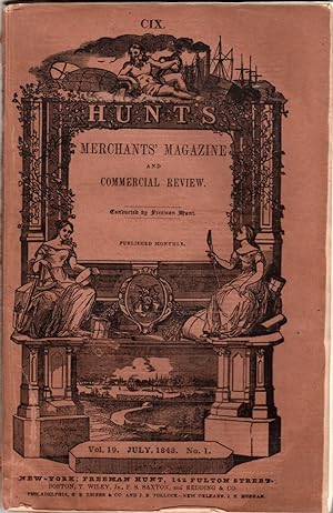
The Merchant Magazine, Volume XIX, Number I, July, 1848
Editore: Freeman Hunt, NY, 1848
Da: Clausen Books, RMABA, Colorado Springs, CO, U.S.A.
Membro dell'associazione: IOBA RMABA
Valutazione del venditore 5 su 5 stelle
Brown, Printed Wraps. Condizione: Good+. Engraved Frontispiece; Tipped in Map of New York City (illustratore). Engraved frontispiece James William Gilbart, General Manager of the London and Westminster Bank; Onion skin map of New York City tipped in at the ffep; A well age-worn, original copy, not a reprint; usual age toning and handling, else textblock is clean and tight; Peeling to head and foot of spine, wear to edges and creased corners. Pages 19-128; This issue includes: Internal Commerce of the West; Commercial Cities and Towns of the United States; Commercial Code of Spain; The Mercantile House of A. and S. Henry and Co; James William Gilbart, and much, much more. Size: 8vo - over 7�" - 9�" tall. Paperback.
-
New York. The Metropolis of the Western World. With 90 Illustrations from Photographs. Fold-out Map and Photograph. First Edition. 1909
Editore: Foster and Reynolds, New York, 1909
Da: sonalsorises, Los angeles, CA, U.S.A.
Valutazione del venditore 2 su 5 stelle

Prima edizione
Condizione: Good Plus. Illustrated, Map, Photographs (illustratore). First Edition. First Edition. Original printed wrappers, worn and chipped along edges, tape-repaired. Front fold-out panorama photograph of New York city scape intact by detached. Fold-out map intact at rear. Profusely illustrated. "A New and Complete Handbook of New York with Map Panorama 90 Views." Quite scarce and important New York historical items. The panorama photograph was taken by Irving Underhill in 1907.".
-
![Immagine del venditore per World at a Glance : The Personal Map. For pocket - handbag - desk. [Vintage world map, 1940] venduto da MW Books](https://pictures.abebooks.com/inventory/md/md14477747702.jpg)
World at a Glance : The Personal Map. For pocket - handbag - desk. [Vintage world map, 1940]
Editore: American Map Company, New York, circa 1940, 1940
Prima edizione
First Edition. The map is in a very good condition, printed on heavy card, with some very slight dulling and edge-nicks. In the original blue and white illustrated envelope, also slightly dulled as with age. Remains particularly well-preserved overall. ; 8vo 8" - 9" tall; 1 pages; Unique vintage map of the world with tabs across the bottom. Contents include: Near East, Europe, North America, Far East, United States (eastern portion), United States (western portion), East Indies (Western Australia), South Pacific (Eastern Australia), Central and South America, So. Africa, and a selection of statistical data. Folds into 7.5 x 16cm. Folds out to 86 x 7.5cm. 3 Kg.
-
![Immagine del venditore per World at a Glance : The Personal Map. For pocket - handbag - desk. [Vintage world map, 1940] venduto da MW Books Ltd.](https://pictures.abebooks.com/inventory/md/md14271410532.jpg)
World at a Glance : The Personal Map. For pocket - handbag - desk. [Vintage world map, 1940]
Editore: American Map Company, New York, circa 1940, 1940
Prima edizione
EUR 60,00
Spedizione EUR 13,95
Spedito da Irlanda a U.S.A.Quantit�: 1 disponibili
Aggiungi al carrelloFirst Edition. The map is in a very good condition, printed on heavy card, with some very slight dulling and edge-nicks. In the original blue and white illustrated envelope, also slightly dulled as with age. Remains particularly well-preserved overall. ; 8vo 8" - 9" tall; 1 pages; Unique vintage map of the world with tabs across the bottom. Contents include: Near East, Europe, North America, Far East, United States (eastern portion), United States (western portion), East Indies (Western Australia), South Pacific (Eastern Australia), Central and South America, So. Africa, and a selection of statistical data. Folds into 7.5 x 16cm. Folds out to 86 x 7.5cm. 1 Kg.
-
North America, Lower Canada and New Brunswick, with Part of New York , vermont and Maine - an Antique Map
Lingua: Inglese
Da: K Books Ltd ABA ILAB, York, YORKS, Regno Unito
Membro dell'associazione: ABA ILAB PBFA
Valutazione del venditore 5 su 5 stelle
EUR 41,79
Spedizione EUR 22,60
Spedito da Regno Unito a U.S.A.Quantit�: 1 disponibili
Aggiungi al carrelloNo Binding. Condizione: Very Good. Engraved By Walker (illustratore). A fine antique map in very good condition - printed in circa 1844. Mounted (matted) and ready to frame. Engraved size approx 16 x 13 Ins, 41 x 33 Cms. Mounted size approx 19 x 16 in, 49 x 41cm. Coloured in outline, hand colouring contemporary. A fine engraved map of North America, Lower Canada and New Brunswick, with Part of New York , vermont and Maine.
-
![Immagine del venditore per Inventory of aerial photography and other remotely sensed imagery of New York State, 1975. 1975 [LeatherBound] venduto da S N Books World](https://pictures.abebooks.com/inventory/md/md31650066519.jpg)
Inventory of aerial photography and other remotely sensed imagery of New York State, 1975. 1975 [LeatherBound]
Lingua: Inglese
Data di pubblicazione: 2025
EUR 26,78
Spedizione gratuita
Spedito da India a U.S.A.Quantit�: 18 disponibili
Aggiungi al carrelloLeatherBound. Condizione: New. BOOKS ARE EXEMPT FROM IMPORT DUTIES AND TARIFFS; NO EXTRA CHARGES APPLY. Leatherbound edition. Condition: New. Leather Binding on Spine and Corners with Golden leaf printing on spine. Bound in genuine leather with Satin ribbon page markers and Spine with raised gilt bands. Pages: 130. A perfect gift for your loved ones. Reprinted from 1975 edition. NO changes have been made to the original text. This is NOT a retyped or an ocr'd reprint. Illustrations, Index, if any, are included in black and white. Each page is checked manually before printing. As this print on demand book is reprinted from a very old book, there could be some missing or flawed pages, but we always try to make the book as complete as possible. Fold-outs, if any, are not part of the book. If the original book was published in multiple volumes then this reprint is of only one volume, not the whole set. IF YOU WISH TO ORDER PARTICULAR VOLUME OR ALL THE VOLUMES YOU CAN CONTACT US. Resized as per current standards. Sewing binding for longer life, where the book block is actually sewn (smythe sewn/section sewn) with thread before binding which results in a more durable type of binding. Language: English Pages: 130.
-
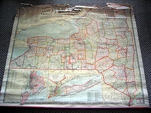
National Publishing Company's New Railroad, Post Office, Township, and County Map of New York with Distances Between Stations. Compiled From the Latest Government and State Surveys and Original Sources
Editore: National Publishing Company, [ca. 1905 ] Boston, 1905
Da: DR Fine Arts, New York, NY, U.S.A.
Valutazione del venditore 3 su 5 stelle

Cloth. Condizione: Fair. This is a very detailed, handsome and at the bottom are 2 large- scale map insets: "Map of New York City (Greater New York) and Vicinity" and "Southeastern Part of New York including all of the City of New York, and Long Island."; on a scale of one half mile to the inch; rolled map size: 39-1/4 x 44-1/4in, with printed color; Numerous tables and charts, including: "List of all Steam Railroads in New York State," "Steamship Lines from New York, Jersey City and Hoboken," "County and County Seats, from Census of 1900."; reference: not in Rumsey; the map has browning from the chemical coating; it is cloth-backed, rolled and with long wood at bottom but not at top; tiny tears to the edges; the top of the map is badly torn and needs repairs; but the map is clear except for the top, otherwise in FAIR COND.
-
National Publishing Company's new railroad, post office, township and county map of New York with distances between stations. . . .
Editore: National Publishing Co., [1901]., Boston, MA:, 1901
Da: Zephyr Used & Rare Books, Vancouver, WA, U.S.A.
Membro dell'associazione: ABAA CBA ESA ILAB
Valutazione del venditore 5 su 5 stelle
Prima edizione
8vo. 5 x 9.75 in. which folds out into large 46 x 42 in. colour lithograhed map, linen-backed as issued. Black decorated ribbed cloth publisher's boards, gilt decorated lettering & ornament stamped on front cover (some scuffing, edgewear, light age toning to map, some lifting to linen backing on verso), still a VG copy. First edition, thus, of this updated National Publishing Co. New York map issued the same year as the Pan-American International Exposition held in Buffalo, NY and also the same year that the Scarborough brothers Walter (1862-1904), and Howard (1867-1905) had moved their mapping business from Portland, ME to Boston, MA. This map features inset maps for the "Southeastern Part of New York, including all the City of New York and Long Island," and "New York City and Vicinity," along with list of all Steam Railroads in New York. Prior to both their deaths from tuberculosis within just a few years, the brothers had opened an office in Indianapolis, IN, and the company later became the Scarborough Motor Guide Co. until 1933. Worldcat locates 2 copies (Buffalo & Erie County Pub. Lib., Cornell).
-
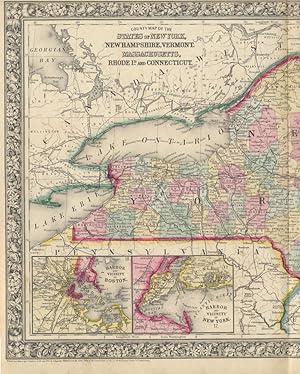
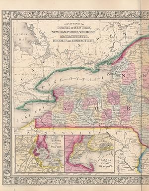
County Map of the States of New York, New Hampshire, Vermont, Massachusetts, Rhode Id. and Connecticut
Editore: S. Augustus Mitchell, Jr., New York, 1860
Da: Main Street Fine Books & Mss, ABAA, Galena, IL, U.S.A.
Membro dell'associazione: ABAA ILAB MWABA
Valutazione del venditore 5 su 5 stelle
Mappa
Folio (23�" X 15�", image area 21�" X 13�"). Hand colored. Very good. Slightly age toned and mildly soiled about the edges, with single vertical fold (as issued). Nice centerfold map of New England, from the 1864 edition of "Mitchell's New General Atlas, Containing Maps of the Various Countries of the World, Plans of Cities, Etc." Two insets at lower left show "Harbor and Vicinity of Boston" and "Harbor and Vicinity of New York." Well colored, with sharp floral border.
-
Space (Signed Limited edition)
Editore: New York: Random House, 1982, 1982
Da: Brainerd Phillipson Rare Books, Holliston, MA, U.S.A.
Membro dell'associazione: SNEAB
Valutazione del venditore 5 su 5 stelle
Prima edizione Copia autografata
Michener, James A. Space New York: Random House, 1982. First edition, no. 80 of 500 specially bound, numbered copies, signed by the author. Map endpapers. [xii], 622, [2] pp. 1 vols. 8vo. Silver cloth boards, titled in silver. Fine copy in black sl (illustratore). 1st Edition. Handsomely bound in finely woven silver cloth stamped in black. With attractive map endpapers. Very clean and tight throughout; a collector's condition copy. In a sturdy protective black cardboard slipcase with a touch of sunning to the bottom edge. First edition,Number 46 of 500 specially bound, numbered copies, signed by the author. Stated "First Edition" with the correct number line. Signed.
-
Listen! the Wind
Editore: New York: Harcourt, Brace and Company, 1938, New York, 1938
Da: Brainerd Phillipson Rare Books, Holliston, MA, U.S.A.
Membro dell'associazione: SNEAB
Valutazione del venditore 5 su 5 stelle
Prima edizione
LINDBERGH, Anne Morrow Listen! the Wind New York: Harcourt, Brace and Company, 1938. First edition. Foreword and map drawings by Charles A. Lindbergh. Neat ownership signature of American woman artist Meta Grimm Lacey, a couple of tiny spots on t (illustratore). Attractively bound in woven red cloth stamped in gilt with a plane own the front boards and the spine. With a touch of fading to the spine. In a very good dust jacket with the price of $2.50 and a faint vertical crease along the front inside flap. Faint scratch to the center of the front panel of the jacket.
-
Travels In The Interior Districts of Africa; Performed Under The Direction and Patronage Of The African Association, In The Years 1795, 1796, and 1797.With An Appendix, Containing Geographical Illustrations of Africa by Major Rennell
Editore: J. Tiebout, New York, 1800
Da: The First Edition Rare Books, LLC, Cincinnati, OH, U.S.A.
Membro dell'associazione: ABAA ILAB IOBA MWABA
Valutazione del venditore 5 su 5 stelle
Full calf. Condizione: Very good. The first American edition of Travels In the Interior Districts of Africa by Mungo Park, published in New York in 1800, with the large fold-out map of Africa. (illustratore). First American Edition. Octavo, 354pp, [2], 86pp. appendix. Full calf, title in gilt on spine over red morocco label. Previous ownership inscription on front endpaper and title page, title page with top edge removed. Occasional light foxing and transference, solid text block. Includes the large fold-out map of Africa, solid hinges, free of notable foxing. Map laid-in. (Evans 38189) Includes the 2pp titled "A Negro Song.".
-
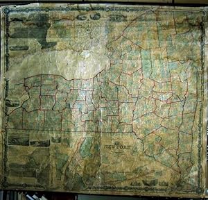
THE STATE OF NEW YORK from New and Original Surveys. 1860 (a very large wall Map)
Editore: Robert Pearsall Smith, Syracuse, 1860, 1860
Da: DR Fine Arts, New York, NY, U.S.A.
Valutazione del venditore 3 su 5 stelle
Soft cover. Condizione: Poor. With two insetted maps: "Geological and Land Patent Map of the State of New York" & "Meteorological Map of the State of New York."; with twelve insetted city plans: Buffalo, Troy, Utica, Syracuse, Albany, Oswego, Schenectady, Hudson, Auburn, Poughkeepsie, Rochester, New York City; also with twelve pictorial vignettes of New York State towns and scenery, and a decorative floral border: size: 6 x 5-1/2 feet OR 65 x 71 ins. (168 x 183 cm.) ; "The second edition of the best map of any American state published to its time. Ristow devotes an entire chapter to the construction of this map, and pronounced it of a "higher quality than the maps of other states published prior to the Civil War." From 1853, Robert Pearsall Smith contracted with a number of local surveyors to construct maps of New York counties. In 1855 he engaged John Homer French to compile a state map from the various county maps. Although the individual county maps were not all of uniform quality, they were far more comprehensive and uniform than the local surveys conducted for any other American state. French's general map of THE STATE OF NEW YORK, first published in 1859, supplanted Burr's ATLAS OF THE STATE OF NEW YORK (1829) as the definitive reference for the topography of the state. It remained so until two decades later, when the U.S. Geological Survey began publishing maps based on original triangulation. This second edition was published in 1860. Despite the quality of the map, the number of copies sold was insufficient to offset costs, and in 1865 Smith sold his publication rights to H.H. Lloyd, who brought out new editions. No edition in Rumsey. PHILLIPS, MAPS, p.513. RISTOW, AMERICAN MAPS & MAPMAKERS, pp.355-78". ; before being hung again it would need to be professionally repaired; the original clear coating has all yellowed; it is now backed with old linen but still holding map together; with original wooden rollers; the small tie cords at top are beginning to detach; there are cracks in image and stains thru out but all the map is attached; pulled at top wood edges but still attached; water stains mostly in the corners; again stating it would need to be professionaly repaired before hung; condition is poor but all present and being sold as is.
-
[I]. NARRATIVE OF THE EXPEDITION OF AN AMERICAN SQUADRON TO THE CHINA SEAS AND JAPAN, PERFORMED IN THE YEARS 1852, 1853, AND 1854, UNDER THE COMMAND OF COMMODORE M. C. PERRY, UNITED STATES NAVY, BY ORDER OF THE GOVERNMENT OF THE UNITED STATES. - COMPILED FROM THE ORIGINAL NOTES AND JOURNALS OF COMMODORE PERRY AND HIS OFFICERS, at his Request, and under his Supervision, by Francis L. Hawks, D.D. L.L.D.; WITH NUMEROUS ILLUSTRATIONS*. --- SENATE EDITION, P. G. WASHINGTON'S COPY; INSCRIBED BY HIM to then German U.S. Ambassador Friedrich Karl Joseph Freiherr von Gerolt. / II. 33rd Congress, 2nd Session: REPORTS ON NATURAL HISTORY AND ECONOMIC GEOGRAPHY incl. the Facsimile of the 'Treaty of Kanagawa'. / III 'UNITED STATES JAPAN EXPEDITION: OBSERVATIONS ON THE ZODIACAL LIGHT, from April 2, 1853, to April 22, 1855, made chiefly on Board the United States Steam-Frigate Mississippi, during her late Cruise in Eastern Seas, and her Voyage homeward; with Conclusions from the Data thus obtained.'. -
Editore: Washington, Beverley Tucker - Senate Printer (I/III) / A.O.P. Nicholson (House Printer), 1856/1857., 1857
Da: C O - L I B R I , Bremen - Berlin ; Deutschland / Germany ., Berlin, Germania
Valutazione del venditore 5 su 5 stelle
Prima edizione
EUR 1.800,00
Spedizione EUR 45,00
Spedito da Germania a U.S.A.Quantit�: 1 disponibili
Aggiungi al carrelloI. 2 blank sheets, XVII (I); 537 pages, with 78 xylographic illustrations in the text; 86 singleside-printed toned or colour-lithographic plates (incl. portraits after Daguerreotypes by Eliphalet Brown) and 3 foldout-colourplates of japanese woodblock-prints (89 plates in total) and 3 geographical maps (1 foldout) bound within; 2 blank sheets. / II. (House Edition, 1857). (8) 414, (1) 14 pages ('Treaty of Ka-na-ga-wa'[Kanagawa], the first document ever negotiated by the Empire of Japan with any western nation according to International Law), (1) XI (1) p.; some xylographic text-illustrations, 4 (3 coloured) lithographic plates 'Agriculture of China', 22 (of 23, 17 [hand-]coloured) plates of Natural History (Yack, Japanese Fox), Ornithology (Japanese Birds, 5 of 6), Ichthyology (Japanese Fishes, 10), Conchyology (Japanese Shells, 5); 3 (2 folded) maps in the text, 16 plates with meteorological diagrams; 15 of 17 very large multiple folded maps at the end. / III. XLIII, 705 pages with 365 (of 366) astronomic xylographic plates (lacking plate 66); all plates in I and II on singleside printed cardboards. - I. Thick and heavy 'night-blue' full morocco-binding of the period over 4 raised bands with gilt-ornamental frames at panels and bands and gilt title and owner's name ('P. G. Washington') at bottom-of-spine, colour-marbled endpapers; II./III. Blind-tooled (naval motive) publisher's cloth bindings; lex.-4to.(ca. 31 x 23 x 20 cm; ca. 9 kg.). *** (Sabin #30958, Cordier 'Japonica' #513, Nissen ZBI #3132) I. FIRST EDITION, BIBLIOPHILE BOUND ORIGINAL; THE SENATE-EDITION (Senate executive Documents #34 of 33rd Congress, 2nd Session), published parrallel to Nicholson's 'House-Editon'. - FIRST BLANK SHEET WITH 4-LINE INSCRIPTION ''to Baron Gerolt / with the kind regards / of P. G. Washington / Feby. 16 1857''. Peter Grayson Washington (1798-1872), son of the Nephew of a Cousin of George Washington (1732-1799, American Founding Father and first President of the United States) served as 'Assistant Secretary of the Treasury Virginia New York City'; Friedrich Karl Joseph Freiherr von Gerolt (1797-1879) was the German-Prussian 'Envoy Extraordinary and Minister Plenipotentiary in the United States' and has been the longest-ever serving ambassador of Germany in the U.S. In the quarter+ century of service, Gerolt met presidents James K. Polk, Zachary Taylor, Millard Fillmore, Franklin Pierce, James Buchanan, Abraham Lincoln, Andrew Johnson and Ulysses Grant. As a studied mining geologist (Freiberg Mining Academy) in ''1824 he travelled to Mexico as an agent of the German-American Mining Association, where significant silver mines were suspected. Together with Carl de Berghes, also an Mining Association Agent, he published the 'Carta geognostica de los principales distritos minerales del Estado de Mexico' in 1827 with Arnz & Comp., a special mineralogical map of central Mexico, which is considered the first geological map of Mexico printed in colour.''(german wikipedia). - Corners of the leather-binding partly somewhat rubbed, panels slightly rubbed and slightly scratched; some textpages opposite of lithographic plates with slight offsetting (shadow) last sheets with slim humidity-stain at top sharp-corner, last 10 sheets (incl. rear endpaper) with small hole in the blank bottom margin; A MAGNIFICIENT COPY WITH A 'WELL NAMED' ASSOCIATION OF THE PERIOD. --- II. Binding somewhat rubbed, lacks plate 6 of Ornithology and textpages 257-262 (beginning of Ichthyology); Acceptably used. / III. Binding rubbed, many pages with humiditystain at foreedge or top sharp-corner (growing towards the end), lacks zodiac-plate #66 (of 352). --- MAIN OFFER IS THE LUXOURIUS EQUIPPED AND COMPLETE HISTORIC ASSOCIATION COPY OF VOLUME I; Vols. II and III have been added from another set to create scientific completeness (more or less). . .
-
An Authentic Narrative Of The Loss Of The American Brig Commerce; Wrecked On The Western Coast Of Africa, In The Month Of August, 1815. With An Account Of The Sufferings Of Her Surviving Officers and Crew, Who Were Enslaved By The Wandering Arabs On the Great African Desart, Or Zahahrah
Editore: T. & W. Mercein, New York, 1817
Da: The First Edition Rare Books, LLC, Cincinnati, OH, U.S.A.
Membro dell'associazione: ABAA ILAB IOBA MWABA
Valutazione del venditore 5 su 5 stelle
Prima edizione Copia autografata
Leather bound. Condizione: Very good. The first edition of the An Authentic Narrative of the Loss of the American Brig Commerce, signed by Captain James Riley to Senator John Milton Niles, published in 1817 in New York. Complete with all plates and map of Africa. (illustratore). First Edition. Octavo, xiv, [errata], [1], 533pp, [543]-554 appendix, [xvi]. Modern full brown calf, title in gilt over black morocco label. General toning and foxing throughout text block. Complete with nine plates and a map of Africa, all plates with general toning, two with archival repairs, one with archival tissue repair. Map of Africa exceptionally bright, free of foxing. (Sabin 71397) This copy is inscribed to Connecticut Senator John Milton Niles, "by his friend, James Riley." Senator John Milton Niles was a lifelong abolitionist and friend of Capt. James Riley. In 1842, Niles edited the Journal of the Loss of the Brig Commerce by Archibald Robbins, a member of Riley's crew, whose story of heroism continued to fascinate readers. This first edition of "Riley's Narrative" was issued in New York and Hartford in 1817, both with 9 plates and a map of Africa. Signed.
-
County Map of the States of New York, New Hampshire, Vermont, Massachusetts, Rhode Id. and Connecticut
Editore: S. Augustus Mitchell, Jr., New York, 1860
Da: Main Street Fine Books & Mss, ABAA, Galena, IL, U.S.A.
Membro dell'associazione: ABAA ILAB MWABA
Valutazione del venditore 5 su 5 stelle
Mappa
Folio (23�" X 15�", image area 21�" X 13�"). Hand colored. Very good. Faintly age toned, with single vertical fold (as issued). Bright and quite attractive centerfold map of New England, from the 1864 edition of "Mitchell's New General Atlas, Containing Maps of the Various Countries of the World, Plans of Cities, Etc." Two insets at lower left show "Harbor and Vicinity of Boston" and "Harbor and Vicinity of New York." Handsomely colored, with fine decorative border.
-
Map of the State of New York Compiled from the Latest Authorities
Editore: Charles Desilver, Philadelphia, 1856
Da: Main Street Fine Books & Mss, ABAA, Galena, IL, U.S.A.
Membro dell'associazione: ABAA ILAB MWABA
Valutazione del venditore 5 su 5 stelle
Mappa
27" X 17�" (image 26" X 16"). Hand colored. inset counties and townships population table. Very good. Minor discoloration along bottom edge (not touching image); 2" separation at bottom of center fold (archivally repaired on verso).
-
A Plan of the Country from Frog's Point to Croton River showing the Positions of the American and British Armies.
Editore: From Marshall's Life of Washington. Philadelphia. c. 1807., 1807
Da: Bickerstaff's Books, Maps &c., Scarborough, ME, U.S.A.
Membro dell'associazione: ABAA ESA ILAB MABA
Valutazione del venditore 4 su 5 stelle
A detailed map of the area from "New York Island" (Manhattan) north to "Heights of North Castle" and centered on White Plains. The map shows the movement of the American troops from October 12 to the 27th, 1776. A somewhat light impression. Appears to have been cleaned. 16 x 8 1/2.".
-

Plan of Peekskill, Westchester Co., N.Y.
Editore: [F. W. Beers], [New York], 1867
Da: Nat DesMarais Rare Books, ABAA, Portland, OR, U.S.A.
Membro dell'associazione: ABAA CBA ILAB
Valutazione del venditore 3 su 5 stelle
First edition. 26 3/4 x 20 1/2 inches (neatlines; 24 1/4 x 17 1/4 inches). Hand-colored and with an inset of Cortlandt Cemetery (in green). At the lower right corner there is a "Peerskill Business Advertising Directory." Remains of stub on verso. some short tears to blank margins (none extend into the neatline). A very attractive map/plat.This is map number 20 (so printed on the upper blank margin) from the "Atlas Of New York And Vicinity From Actual Surveys by and under the direction of F.W. Beers" and published by Beers in 1867. Peekskill is now rightly well-known as a arts community with artists? studios and art galleries galore. More than 100 art studios are housed in the older buildings and homes.
-
Guide to the Walter Whitehead Dinner given by The Art Directors Club of New York at Janssen's Hofbrau Broadway and 30th Street, New York.
Editore: Advertising Agencies' Service Co New Yorkn.y., New York
Da: Main Street Fine Books & Mss, ABAA, Galena, IL, U.S.A.
Membro dell'associazione: ABAA ILAB MWABA
Valutazione del venditore 5 su 5 stelle
Mappa
Folio (13�" X 17", folds down to 3�" X 8�"), housed in 8vo stiff green pictorial folder (cover title: "Map of New York"). Map very good, folder near fine. 1" edge tear near the center of the top edge, along one of the fold lines (neatly, archivally closed on verso); original, as-issued folds present but otherwise not weakened. This delightful, cartoonish map is printed in black on a thin, translucent onion-skin paper, and depicts a small area of Manhattan. Cartouche (in shape of a hip flask!) at lower right bears title cited above (along with "April 30th 7 P.M. / Make your reservations now / no tickets sold at the door"). Within this roughly-rectangular shaped decorative border runs the following (one line to each side): "FOR ITS ALWAYS FAIR WEATHER / WHEN GOOD FELLOWS GET TOGETHER / WITH A STEIN ON THE TABLE / AND A GOOD SONG RINGING CLEAR." Above this border, along the top edge, runs the caption in mock Colonial style: "Plates Respektfully & Mechanickally ENGRAV'D by Ye HAGOPIAN PHOTO ENGRAVING CO., Inc., Artisans of Greate SKILL, Expressly for Ye Occasion, and for ye PLEASURE of Master WHITEHEAD in Especiall." Below this border, along the bottom edge, runs another mock Colonial caption: "Printed & Bound with CARE by Ye Craftsmen yclept: Advertising Agencies' Service Co., And PRESENTED Gratis, albeit with GOOD GRACE, to Ye MOST WORSHIPPFULL Company of Ye ART Directors." The map itself shows the several block radius around the intersection of Broadway and 30th Street, with a number of buildings (Hofbrau, Lipsitz Bros. Cloaks & Suits, Daly's Theatre, John L's Place, etc.) depicted rather three-dimensionally. A Chinaman puffs a pipe atop a chop suey restaurant, a horse-drawn carriage rolls down a street, two cats face off atop a building and other bits of activity take place throughout. Commercial artist Walter Whitehead was born in 1874, and died in 1956, which helps date this undated piece -- presumably to later in his life, perhaps his retirement. The Art Directors Club was founded in 1920 "for the progress of art in advertising and industry" (according to their 1921 exhibition catalogue) and both Otto Rebele and Whitehead were among its founding members. About Rebele little is known. He was born around 1878 and was both commercial artist and book illustrator. This scarce and delicate map is a rare survivor, obviously printed in a small quantity for distribution to the membership of this specialized trade association.
-
Geographisch, statistische und historische Charte von Neuyork.
Editore: Im Verlage des Geographischen Instituts. Weimar. 1824., 1824
Da: Bickerstaff's Books, Maps &c., Scarborough, ME, U.S.A.
Membro dell'associazione: ABAA ESA ILAB MABA
Valutazione del venditore 4 su 5 stelle
This is the map of New York from the very scarce German edition of Carey & Lea's "A Complete Historical, Chronological, and Geographical American Atlas.," first published in 1822. The map is surrounded by text (in German) describing the state, its 53 counties and principal cities. Rare. Very good, clean example. Color outline of counties. Page size, including surrounding text: 19 1/4 x 24 3/8.".