
Importo totale (1 articolo articoli):
Destinazione ordine:

richard andrees (68 risultati)
Vai alla pagina principale dei risultati di ricerca
Filtri di ricerca
Tipo di articolo
- Tutti i tipi di prodotto
- Libri (67)
- Riviste e Giornali (Nessun altro risultato corrispondente a questo perfezionamento)
- Fumetti (Nessun altro risultato corrispondente a questo perfezionamento)
- Spartiti (Nessun altro risultato corrispondente a questo perfezionamento)
- Arte, Stampe e Poster (Nessun altro risultato corrispondente a questo perfezionamento)
- Fotografie (Nessun altro risultato corrispondente a questo perfezionamento)
- Mappe (1)
- Manoscritti e Collezionismo cartaceo (Nessun altro risultato corrispondente a questo perfezionamento)
Condizioni Maggiori informazioni
- Nuovo (Nessun altro risultato corrispondente a questo perfezionamento)
- Come nuovo, Ottimo o Quasi ottimo (1)
- Molto buono o Buono (5)
- Discreto o Mediocre (6)
- Come descritto (56)
Legatura
Ulteriori caratteristiche
- Prima ed. (Nessun altro risultato corrispondente a questo perfezionamento)
- Copia autograf. (Nessun altro risultato corrispondente a questo perfezionamento)
- Sovracoperta (Nessun altro risultato corrispondente a questo perfezionamento)
- Con foto (56)
- Non Print on Demand (68)
Lingua (2)
Spedizione gratuita
- Spedizione gratuita in U.S.A. (Nessun altro risultato corrispondente a questo perfezionamento)
Paese del venditore
Valutazione venditore
-
Alphabetisches Namenverzeichnis zu Andrees allgemeinem Handatlas in 91 Haupt- und 86 Nebenkarten
Lingua: Tedesco
Editore: Velhagen & Klasing, 1893
Da: avelibro OHG, Dinkelscherben, Germania
Membro dell'associazione: BOEV
Valutazione del venditore 5 su 5 stelle

EUR 15,00
Spedizione EUR 10,00
Spedito da Germania a U.S.A.Quantit�: 1 disponibili
Aggiungi al carrello4�, gebundene Ausgabe. Condizione: Befriedigend. Deckel stark lagerspurig, Buchr�cken mit fehlenden Teilst�cken, Seiten altersgem�� angedunkelt, einzelne Seiten mit ein oder zwei geknickten Ecken, Seiten sonst sehr gut erhalten B05-01-01A Sprache: Deutsch Gewicht in Gramm: 951.
-
Andrees Berliner Schulatlas. Vollst�ndige Ausgabe.
Editore: Bielefeld, Leipzig und Berlin; Velhagen & Klasing, 1939. 30. v�llig neubearbeitete Auflage., 1939
Da: Antiquariat Carl Wegner, Berlin, B, Germania
Membro dell'associazione: GIAQ
Valutazione del venditore 5 su 5 stelle
EUR 57,00
Spedizione EUR 9,00
Spedito da Germania a U.S.A.Quantit�: 1 disponibili
Aggiungi al carrelloHardcover. 4�. Stark beriebener Pappband, der R�cken fehlend, die Bl�tter zumeist lose. Ein Besitzvermerk auf dem Vorsatz. Bei uns vorhanden: 1 Bl. Titel und Inhaltsverzeichnis; XX Karten Verwaltungsbezirke Berlins und Umgebungen; 12 S. Bilder und Karten aus der Mark Brandenburg, M�rkische Landschaften, Boden und Besiedlung etc.; 49 (+1) S. Die Landschaft in Karte und Bild, d.dt. Volksboden, Besiedlung, Volkstum etc.; 4 S. Statistischer Anhang; 1 Bl. Mit S-Bahn und U-Bahn Plan; 32 S. Deutschland und die weite Welt. Bilderanhang zu Velhagens Schulatlanten. In hiinterer Deckellasche 12 Geographische Tafeln auf 8 Seiten und 4 weitere wohl privat zusammengestellte Karten - wohl deutlich �berkomplettes Exemplar. Die Bl�tter teils gedunkelt, in den Randbereichen begriffen und mit Schadstellen. Einige Falze leider mit Tesa hinterlegt. Arbeitsexemplar des seltenen Berliner Schulatlas. Die im Inhaltsverzeichnis angegeben Beilage fehlt ( wurde �berhaupt ausgeliefert?). -- Bitte Portokosten au�erhalb EU erfragen! / Please ask for postage costs outside EU! / S ' il vous plait demander des frais de port en dehors de l ' UE! // Bitte beachten Sie auch unsere Fotos! / Please also note our photos! / Veuillez noter nos photos -- Nehmen Sie sich ein gutes Buch mit auf die Sommerwiese. Bei uns werden Sie f�ndig! -- Wir kaufen Ihre werthaltigen B�cher! K04004.
-

�gypten. Landkarte im Ma�stab 1 : 5.000.000
Lingua: Tedesco
Editore: Verlag von Velhagen & Klasing, Bielefeld und Leipzig, 1887
Da: Paderbuch e.Kfm. Inh. Ralf R. Eichmann, Bad Lippspringe, NRW, Germania
Valutazione del venditore 5 su 5 stelle
EUR 12,00
Spedizione EUR 35,00
Spedito da Germania a U.S.A.Quantit�: 1 disponibili
Aggiungi al carrelloUnbound. Condizione: acceptable. Richard Andrees (Hrsg.): �gypten. Landkarte im Ma�stab 1 : 5.000.000, Format 23 x 38 cm, grenzkoloriert, einmal gefaltet, sonst ordentlicher Zustand. Mit 2 Nebenkarten: Umgebung von Kairo - Umgebung von Chartum. Verlag von Velhagen & Klasing, Bielefeld und Leipzig 1887 (aus "Allgemeiner Handatlas").
-

Afghanistan und Belutschistan. Landkarte im Ma�stab 1 : 6.000.000
Lingua: Tedesco
Editore: Verlag von Velhagen & Klasing, Bielefeld und Leipzig, 1887
Da: Paderbuch e.Kfm. Inh. Ralf R. Eichmann, Bad Lippspringe, NRW, Germania
Valutazione del venditore 5 su 5 stelle
EUR 12,00
Spedizione EUR 35,00
Spedito da Germania a U.S.A.Quantit�: 1 disponibili
Aggiungi al carrelloUnbound. Condizione: acceptable. Richard Andrees (Hrsg.): Afghanistan und Belutschistan. Landkarte im Ma�stab 1 : 6.000.000, Format 24 x 36 cm, grenzkoloriert, einmal gefaltet, sonst ordentlicher Zustand. Verlag von Velhagen & Klasing, Bielefeld und Leipzig 1887 (aus "Allgemeiner Handatlas").
-

Provinz Sachsen, Mecklenburg und Anhalt. Landkarte im Ma�stab 1 : 1.250.000,
Lingua: Tedesco
Editore: Verlag von Velhagen & Klasing, Bielefeld und Leipzig, 1887
Da: Paderbuch e.Kfm. Inh. Ralf R. Eichmann, Bad Lippspringe, NRW, Germania
Valutazione del venditore 5 su 5 stelle
EUR 12,00
Spedizione EUR 35,00
Spedito da Germania a U.S.A.Quantit�: 1 disponibili
Aggiungi al carrelloUnbound. Condizione: acceptable. Richard Andrees (Hrsg.): Provinz Sachsen, Mecklenburg und Anhalt. Landkarte im Ma�stab 1 : 1.250.000, Format 23 x 36 cm, grenzkoloriert, einmal gefaltet, sonst ordentlicher Zustand. Verlag von Velhagen & Klasing, Bielefeld und Leipzig 1887 (aus "Allgemeiner Handatlas").
-

K�nigreich D�nemark. Landkarte im Ma�stab 1 : 1.500.000
Lingua: Tedesco
Editore: Verlag von Velhagen & Klasing, Bielefeld und Leipzig, 1887
Da: Paderbuch e.Kfm. Inh. Ralf R. Eichmann, Bad Lippspringe, NRW, Germania
Valutazione del venditore 5 su 5 stelle
EUR 12,00
Spedizione EUR 35,00
Spedito da Germania a U.S.A.Quantit�: 1 disponibili
Aggiungi al carrelloUnbound. Condizione: acceptable. Richard Andrees (Hrsg.): K�nigreich D�nemark. Landkarte im Ma�stab 1 : 1.500.000, Format 23 x 37 cm, grenzkoloriert, einmal gefaltet, sonst ordentlicher Zustand. Mit drei Nebenkarten: Bornholm - Island - Die Far-�er. Verlag von Velhagen & Klasing, Bielefeld und Leipzig 1887 (aus "Allgemeiner Handatlas").
-

Namenverzeichnis zu Andrees Handatlas
Da: Antiquariat Librissimo, Eicklingen, Germania
Valutazione del venditore 5 su 5 stelle
EUR 12,00
Spedizione EUR 45,00
Spedito da Germania a U.S.A.Quantit�: 1 disponibili
Aggiungi al carrelloSechste Auflage. Velhagen & Klasing, Bielefeld und Leipzig, 1914. 532 Seiten. Quart, Leinen (berieben/ kleine Sto�stelle am Vordergelenk)---.
-

Andrees Handatlas. Allgemeiner Handatlas in hundertzwanzig kartenseiten nebst alphabetischem Namenverzeichnis.
Editore: Velhagen & Klasing, Bielefeld, Leipzig, 1890
Da: Antiquariat Puderbach, Dresden, Germania
Valutazione del venditore 5 su 5 stelle
EUR 35,00
Spedizione EUR 48,00
Spedito da Germania a U.S.A.Quantit�: 1 disponibili
Aggiungi al carrelloHalbleder 43x29 cm, Einband stark berieben, Ecken und R�cken besto�en, R�cken mit gr. Fehlstelle, Bindung gelockert, Buchblock gebrochen, Seiten fingerfleckig, Namenseintrag auf Titelseite, einige Seiten besch�digt oder mit kl. Markierungen. 117 S. Gewicht in Gramm: 3700 Zweite vermehrte und verbesserte Auflage, Zweiter revidierter Abdruck.
-
Dr. Richard Andrees allgemeiner Schul-Atlas. Ausgabe A
Da: Celler Versandantiquariat, Eicklingen, Germania
Membro dell'associazione: GIAQ
Valutazione del venditore 5 su 5 stelle
EUR 21,00
Spedizione EUR 38,00
Spedito da Germania a U.S.A.Quantit�: 1 disponibili
Aggiungi al carrello39. Aufl., Velhagen & Klasing, Bielefeld, 1893. 34/8 S., Hln., quart, (Titelrand hinterlegt/stark bst.)--- 750 Gramm.
-

Hannover, Schleswig-Holstein und kleinere Norddeutsche Staaten. Landkarte im Ma�stab 1 : 1.000.000
Lingua: Tedesco
Editore: Verlag von Velhagen & Klasing, Bielefeld und Leipzig, 1887
Da: Paderbuch e.Kfm. Inh. Ralf R. Eichmann, Bad Lippspringe, NRW, Germania
Valutazione del venditore 5 su 5 stelle
EUR 17,00
Spedizione EUR 35,00
Spedito da Germania a U.S.A.Quantit�: 1 disponibili
Aggiungi al carrelloUnbound. Condizione: acceptable. Richard Andrees (Hrsg.): Hannover, Schleswig-Holstein und kleinere Norddeutsche Staaten. Landkarte im Ma�stab 1 : 1.000.000, Format 37 x 46 cm, grenzkoloriert, zweimal gefaltet, sonst ordentlicher Zustand. Mit drei Nebenkarten: Umgebung von Hamburg - F�rstentum Birkenfeld - Umgebung von Kiel. Verlag von Velhagen & Klasing, Bielefeld und Leipzig 1887 (aus "Allgemeiner Handatlas").
-

Andrees Allgemeiner Handatlas in 99 Haupt- und 82 Nebenkarten, nebst vollst�ndigem Namenverzeichnis. Dritte, v�llig neubearbeitete und vermehrte Auflage. Zweiter revidierter und vermehrter Abdruck.
Editore: Bielefeld und Leipzig; Verlag von Velhagen & Klasing, 1896
Da: Antiquariat Hanfgarten, Heimiswil, CH, Svizzera
Valutazione del venditore 5 su 5 stelle
EUR 50,54
Spedizione EUR 14,50
Spedito da Svizzera a U.S.A.Quantit�: 1 disponibili
Aggiungi al carrelloAtlasband 140 Blatt, 188 Seiten; zus�tzlich separates Namenverzeichnis zur 6. Auflage gedruckt 1924 mit 592 Seiten. Altlas Halbledereinband, Namenverzeichnis Kunstledereinband. Atlas R�cken oben und unten eingerissen, Einband st�rkere Gebrauchsspuren, Ecken bestossen; innen gute Erhaltung. Zuschlag Paketpost 6'500 g (RO).
-
Supplement zur zweiten und ersten Auflage von Andrees Handatlas erhaltend die 64 Seiten neuer Karten der dritten Auflage von 1893. Apart f�r die Besitzer der zweiten und ersten Auflage.
Editore: Bielefeld und Leipzig; 1893, 1893
Da: Antiquariaat De Boekenbeurs, Middelburg, Paesi Bassi
Membro dell'associazione: ILAB NVVA
Valutazione del venditore 5 su 5 stelle
EUR 82,50
Spedizione EUR 15,50
Spedito da Paesi Bassi a U.S.A.Quantit�: 1 disponibili
Aggiungi al carrello; Verlag von Velhagen und Klasing; gilt printed portfolio; 29x43 cm.; with 64 folding maps. Portfolio a trifle worn and slight signs of use.
-
Supplement zur zweiten und dritten Auflage von Andrees Handatlas erhaltend die 53 Seiten neuer Karten der vierten Auflage von 1899.
Editore: Bielefeld und Leipzig; 1899, 1899
Da: Antiquariaat De Boekenbeurs, Middelburg, Paesi Bassi
Membro dell'associazione: ILAB NVVA
Valutazione del venditore 5 su 5 stelle
EUR 82,50
Spedizione EUR 15,50
Spedito da Paesi Bassi a U.S.A.Quantit�: 1 disponibili
Aggiungi al carrello; Verlag von Velhagen und Klasing; gilt printed portfolio; 29x43 cm.; with 53 folding maps; edited by A. Scobel. Portfolio a trifle worn.
-

Japan.
Editore: Velhagen & Klasing, 1898]., [Bielefeld and Leipzig,, 1898
Da: Daniel Crouch Rare Books Ltd, London, Regno Unito
Membro dell'associazione: ABA ILAB PBFA
Valutazione del venditore 4 su 5 stelle

Mappa
EUR 47,70
Spedizione EUR 23,16
Spedito da Regno Unito a U.S.A.Quantit�: 1 disponibili
Aggiungi al carrelloFrom the fourth edition of 'Andrees Allgemeiner Handatlas Chromolithograph map. Published in the fourth edition of 'Andrees Allgemeiner Handatlas'. Velhagen & Klasing was a major German publishing company in the nineteenth and twentieth centuries. In the mid-to-late 1800s, Hirt & Sohn and Velhagen & Klasing together had an oligopoly in the German textbook market.
-
Allgemeiner Handatlas in 120 Kartenseiten und zwei Erg�nzungskarten nebst alphabetischem Namensverzeichnis
Lingua: Tedesco
Editore: Velhagen & Klasing, Bielefeld,, 1887
Da: Clerc Fremin, Steingaden, Germania
Valutazione del venditore 5 su 5 stelle
EUR 65,00
Spedizione EUR 22,15
Spedito da Germania a U.S.A.Quantit�: 1 disponibili
Aggiungi al carrello2. Auflage. 122+112 Seiten Vollst�ndig. Zustand: keine Besch�digungen, Exemplar einer Privatbibliothek mit Kennungen. Ecken, Kanten gut. Der R�cken ist unten verletzt. Sprache: Deutsch Gewicht in Gramm: 2001 Hardcover mit Lederr�cken, Leinen, Gro�format.
-

Andrees Allgemeiner Handatlas in 99 Haupt- und 82 Nebenkarten, nebst vollst�ndigem alphabetischem Namenverzeichnis. + Geographisches Handbuch zu Andrees Handatlas mit besonderer Ber�cksichtigung der politischen, wirtschaftlichen und statistischen Verh�ltnisse.
Lingua: Tedesco
Editore: Bielefeld, Leipzig; Verlag von Velhagen & Klasing, 1896 + 1899., 1896
Da: BuchKultur Opitz, Konstanz, BW, Germania
Valutazione del venditore 5 su 5 stelle
EUR 85,00
Spedizione EUR 9,95
Spedito da Germania a U.S.A.Quantit�: 1 disponibili
Aggiungi al carrelloGr.-Fol., OHLdr. 1 Doppelblatt Titel und Inhaltsverzeichnis, 140 Blatt und 188 S.; XII, 994 S. R�cken und Kanten des Atlas mit Nutzungsspuren, ansonsten sehr sch�n erhalten, Bindung und Seiten in sehr gutem Zustand. Geographisches Handbuch in HLdr. mit Lederecken und Marmorschnitt, Lagerspuren am Einband, sch�nes Exemplar. Sprache: Deutsch Gewicht in Gramm: 550 Dritte, v�llig neubearbeitete und vermehrte Auflage. Zweiter revidierter und vermehrter Abdruck.
-
Supplement Andrees Handatlas zur zweiten und ersten Auflage. Apart f�r die Besitzer er zweiten und ersten Auflage.
Editore: Bielefeld u Leipzig Velhagen & Klasing /93, 1887
Da: Neusser Buch & Kunst Antiquariat, Neuss, NRW, Germania
Valutazione del venditore 5 su 5 stelle
EUR 72,00
Spedizione EUR 75,00
Spedito da Germania a U.S.A.Quantit�: 1 disponibili
Aggiungi al carrello1893. neue Kart. d. 2. Aufl. v. 1887 - d. 3. Aufl. v. 1893. 4� OLw.-Mappe. Mappe m. Einrissen u. etwas berieben, Karten leicht gebr�unt u. fingerfleckig, sonst gut erhalten. Sprache: Deutschu 3,200 gr.
-

ALLGEMEINER HANDATLAS IN HUNDERTZWANZIG KARTENSEITEN UND ZWEI ERGANZUNGSKARTEN.
Editore: BIELEFELD UND LEIPZIG, 1887
Da: Le-Livre, SABLONS, Francia
Membro dell'associazione: ILAB
Valutazione del venditore 5 su 5 stelle
EUR 105,00
Spedizione EUR 42,00
Spedito da Francia a U.S.A.Quantit�: 1 disponibili
Aggiungi al carrelloCouverture rigide. Condizione: bon. RO30118594: 1887. In-Folio. Cartonn�. Etat d'usage, Coins frott�s, Mors fendus, Int�rieur acceptable. 122 planches de cartes en couleurs + 105 pages de texte. Texte en allemand. Quelques planches partiellement d�broch�es et deux planches d�broch�es. Un manque sur la planche 27/28. Une �criture et quelques taches d'encres sur la page de titre. Mors du deuxi�me plat fendu sur 4/5 du mords. Coiffes en t�te abim�e. . . . Classification Dewey : 430-Langues germaniques. Allemand.
-
Andrees Handatlas in einem Bande. Herausgegeben von Dr. Konrad Frenzel.
Editore: Bielefeld u Leipzig Velhagen & Klasing, 1937
Da: Neusser Buch & Kunst Antiquariat, Neuss, NRW, Germania
Valutazione del venditore 5 su 5 stelle
EUR 76,00
Spedizione EUR 75,00
Spedito da Germania a U.S.A.Quantit�: 1 disponibili
Aggiungi al carrello0. ausgew., v�llig neu bearb. Aufl. 2�. 16 S., 100 Kart., 122 S. Namenverz., OLw., vergold. R�ck.-u. Deck.-Tit., leicht berieben, papierbedingt etwas gebr�unt, sauber u. gut erhalten. Sprache: Deutschu 8,500 gr.
-
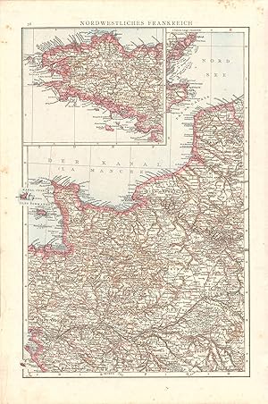
Nordwestliches Frankreich (Northwest France)
Data di pubblicazione: 1887
Da: Art Source International Inc., Boulder, CO, U.S.A.
Valutazione del venditore 5 su 5 stelle
This wonderful map was published by Dr. Richard Andrees in 1887, in Leipzig, Germany. German-made maps of this time period were known for their attention to detail and their fine engraving work. This map of Northwest France is the epitome of fine German printing. This map measures 9.5 inches by 14.5 inches.
-
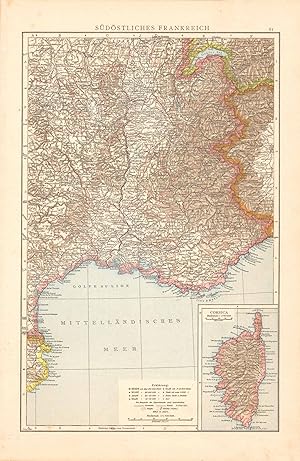
Sudostliches Frankreich (Southeast France)
Data di pubblicazione: 1887
Da: Art Source International Inc., Boulder, CO, U.S.A.
Valutazione del venditore 5 su 5 stelle
This wonderful map was published by Dr. Richard Andrees in 1887, in Leipzig, Germany. German-made maps of this time period were known for their attention to detail and their fine engraving work. This map of Southeast France is the epitome of fine German printing. This map measures 9.5 inches by 14.5 inches.
-

SUPPLEMENT zur ERSTEN AUFLAGE von RICHARD ANDREES HANDATLAS enthaltend de 33 Seiten neuer Karten der zweiten Auflage von 1887 Apart fur die Besitzer der ersten Auflage, etc.
Editore: Von Velhagen & Klasing, Bielefeld und Leipzig, 1887
Da: Gene W. Baade, Books on the West, Renton, WA, U.S.A.
Membro dell'associazione: IOBA
Valutazione del venditore 5 su 5 stelle
Hardcover. Condizione: Fair. First Thus. 1st printing of the supplement, so far as we can tell. Folio in 1/2 leather & cloth. Only a fair copy. Hinges sound but covers spotted & worn & leather degraded. Maps good with marginal stains. The lower fore corner has a triangular stain on several leaves about 2 1/4" along the two edges and arced out 2". Fair.
-
Allgemeiner Handatlas in hundertzwanzig Kartenseiten nebst alphabetischem Namensverzeichnis. Zweite wesentlich verbesserte und um ein Viertel des Umfangs vermehrte Auflage
Lingua: Tedesco
Editore: Velhagen und Klasing, Bielefeld und Leipzig, 1887
Da: Hartmut Diekmann, Berlin, Germania
Valutazione del venditore 5 su 5 stelle
EUR 85,00
Spedizione EUR 18,70
Spedito da Germania a U.S.A.Quantit�: 1 disponibili
Aggiungi al carrelloHardcover. Condizione: Gut. 2. Auflage. gr�n-schwarzer OHld Bandmit goldgepr�gtem Deckel- und R�ckentitel. Ecken lederverst�rkt. Ec ken und R�ckenkanten berieben. R�cken unten eingerissen, oben circa 1cm Leder ausgerissen. Deckel mit geringen Gebrauchsspuren. Innen ausgezeichnet, traumhaft sch�n.
-
Andrees Allgemeiner Handatlas in 91 Haupt- und 86 Nebenkarten nebst vollst�ndigen alphabetischen Namensverzeichnis
Editore: Bielefeld und Leipzig, Verlag von Velhagen & Klasing, 1893, 1893
Da: Antiquariat & Kunsthandlung Bachmann & Rybicki - Dresden, Dresden, Germania
Membro dell'associazione: ILAB VDA
Valutazione del venditore 4 su 5 stelle
EUR 160,00
Spedizione EUR 60,00
Spedito da Germania a U.S.A.Quantit�: 1 disponibili
Aggiungi al carrello2�(42x29cm), 91 Hauptkarten, 86 Nebenkarten, Namensverzeichnis, 2nnS., 140 S.,1nnS., 166 S., Halbleder - Karten sind vollst�ndig. Buchr�cken mit B�nden, Schild goldgepr.(florale Verzierung), Buchdeckel goldgepr., Kanten berieben/besto�en. Buchr�cken vom Block gel�st. Teilw. braunfleckig, erste Seiten leicht wasserrandig, teilw. hs. Vermerke, dritte Auflage.
-
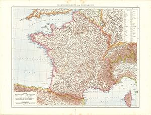
Ubersichtskarte Von Frankreich (Outline Map of France)
Data di pubblicazione: 1887
Da: Art Source International Inc., Boulder, CO, U.S.A.
Valutazione del venditore 5 su 5 stelle
This wonderful map was published by Dr. Richard Andrees in 1887, in Leipzig, Germany. German-made maps of this time period were known for their attention to detail and their fine engraving work. This map of France is the epitome of fine German printing. This map measures 18.5 inches by 14.5 inches.
-
Allgemeiner Handatlas in hundertzwanzig Kartenseiten und zwei Erg�nzungskarten, nebst alphabetischem Namenverzeichnis. Zweite wesentlich verbesserte und um ein Viertel des Umfangs vermehrte Auflage.
Lingua: Tedesco
Editore: Bielefeld u. Leipzig, Velhagen & Klasing, 1887
Da: Antiquariat Olaf Drescher, Nuthe-Urstromtal OT Nettgendorf, Germania
Valutazione del venditore 5 su 5 stelle
EUR 120,00
Spedizione EUR 13,95
Spedito da Germania a U.S.A.Quantit�: 1 disponibili
Aggiungi al carrello1 Blatt Titel und Inhalt des Atlas, 120 farbige Kartenseiten, zwei Erg�nzungskarten (Zentralafrika u. Deutsch-Ostafrika, 112 S. Alphabetisches (siebenspaltiges) Namenverzeichnis. Geographischer Handatlas in besonders gut erhaltenem alten Halbleder-Einband. - Zustand / Condition: Titel etwas gebr�unt, mit 2 Besitzvermerken, sonst sehr gut erhalten / Titel with light browning and two proprietors names, otherwise very fine. Sprache: Deutsch Gewicht in Gramm: 6400 43 x 29,5 cm, braunes Orig.-HALBLEDER mit Lederecken u. goldenem Deckeltitel und Emblem auf gr�nem Einband sowie goldenem R�ckentitel und Jahreszahl am unteren Kapital.
-
Supplement zur Ersten Auflage von Richard Andrees Handatlas
Lingua: Tedesco
Editore: Velhagen & Klasing, Leipzig, 1887
Da: Old Paper Old Ink, Murray, KY, U.S.A.
Valutazione del venditore 4 su 5 stelle
Hardcover. Condizione: Very Good. No Jacket. Richard Andrees. Supplement zur Ersten Auflage von Richard Andrees Handatlas. Bielefeld un d Leipzig: Velhagen & Klasing, 1887, 34 pp. *** A collection of thirty-three (33) engraved lithograph maps with chromolitho. coloring. The European maps (14) are larger scale, regional maps. The remaining maps cover parts of Asia, Africa, Oceana, and the Caribbean Islands. The maps are printed on both sides of a page. This atlas is in my inventory and the images are of this particular item. *** Bound in dark green cloth boards with a black leather spine and black leather corners. Marbled end papers. The covers have light wear and soil with moderate rubbing at corners and spine ends. Two short separations in joints have been repaired. The contents are complete in a good binding, mostly clean except for some light soil and/or foxing in margins of some maps. The maps have fresh, bright colors. *** 16.5 inches tall by 11.75 inches.
-

Hohenschichtenkarte Von Deutschland, Bevolkerungsdichtigkeit Von Deutschland (High Layer Map of Germany, Population Density of Germany)
Data di pubblicazione: 1887
Da: Art Source International Inc., Boulder, CO, U.S.A.
Valutazione del venditore 5 su 5 stelle
This wonderful map was published by Dr. Richard Andrees in 1887, in Leipzig Germany. German-made maps of this time period were known for their attention to detail and their fine engraving work. This high layer map of Germany with population density is the epitome of fine German printing. This map measures 9 inches by 14.5 inches.
-

Provinzen Ost- Und Westpreussen (Provinces of East and West Pussia)
Data di pubblicazione: 1887
Da: Art Source International Inc., Boulder, CO, U.S.A.
Valutazione del venditore 5 su 5 stelle
This wonderful map was published by Dr. Richard Andrees in 1887, in Leipzig, Germany. German-made maps of this time period were known for their attention to detail and their fine engraving work. This map of Provinces of East and West Russia is the epitome of fine German printing. This map measures 14.5 inches by 9 inches.
-

Grosser Ozean (Big Ocean)
Data di pubblicazione: 1887
Da: Art Source International Inc., Boulder, CO, U.S.A.
Valutazione del venditore 5 su 5 stelle
This wonderful map was published by Dr. Richard Andrees in 1887, in Leipzig Germany. German-made maps of this time period were known for their attention to detail and their fine engraving work. This map of the Big Ocean is the epitome of fine German printing. This map measures 14.5 inches by 9 inches.


