Importo totale (1 articolo articoli):
Destinazione ordine:

joannes janssonius (90 risultati)
Vai alla pagina principale dei risultati di ricerca
Filtri di ricerca
Tipo di articolo
- Tutti i tipi di prodotto
- Libri (31)
- Riviste e Giornali (Nessun altro risultato corrispondente a questo perfezionamento)
- Fumetti (Nessun altro risultato corrispondente a questo perfezionamento)
- Spartiti (Nessun altro risultato corrispondente a questo perfezionamento)
- Arte, Stampe e Poster (32)
- Fotografie (Nessun altro risultato corrispondente a questo perfezionamento)
- Mappe (27)
- Manoscritti e Collezionismo cartaceo (Nessun altro risultato corrispondente a questo perfezionamento)
Condizioni Maggiori informazioni
- Nuovo (16)
- Come nuovo, Ottimo o Quasi ottimo (4)
- Molto buono o Buono (14)
- Discreto o Mediocre (Nessun altro risultato corrispondente a questo perfezionamento)
- Come descritto (56)
Legatura
Ulteriori caratteristiche
- Prima ed. (2)
- Copia autograf. (Nessun altro risultato corrispondente a questo perfezionamento)
- Sovracoperta (Nessun altro risultato corrispondente a questo perfezionamento)
- Con foto (60)
- Non Print on Demand (80)
Lingua (3)
Spedizione gratuita
Paese del venditore
Valutazione venditore
-

Atlantis Majoris Quinta Pars Ed 1657 -Language: french
Da: GreatBookPrices, Columbia, MD, U.S.A.
Valutazione del venditore 5 su 5 stelle

EUR 23,75
Spedizione EUR 2,29
Spedito in U.S.A.Quantit�: Pi� di 20 disponibili
Aggiungi al carrelloCondizione: New.
-

Atlantis Majoris Quinta Pars, Orbem Maritimum Seu Omnium Marium Totius Orbis Terrarum (�d.1657) (Paperback or Softback)
Lingua: Francese
Editore: Hachette Livre Bnf 6/1/2012, 2012
ISBN 10: 2012637280 ISBN 13: 9782012637283
Da: BargainBookStores, Grand Rapids, MI, U.S.A.
Valutazione del venditore 5 su 5 stelle
Paperback or Softback. Condizione: New. Atlantis Majoris Quinta Pars, Orbem Maritimum Seu Omnium Marium Totius Orbis Terrarum (�d.1657). Book.
-

Atlantis Majoris Quinta Pars Ed 1657 -Language: french
Da: GreatBookPrices, Columbia, MD, U.S.A.
Valutazione del venditore 5 su 5 stelle
EUR 24,46
Spedizione EUR 2,29
Spedito in U.S.A.Quantit�: Pi� di 20 disponibili
Aggiungi al carrelloCondizione: As New. Unread book in perfect condition.
-

Atlantis Majoris Quinta Pars, Orbem Maritimum Seu Omnium Marium Totius Orbis Terrarum (�d.1657) (Histoire) (French Edition)
Da: Ria Christie Collections, Uxbridge, Regno Unito
Valutazione del venditore 5 su 5 stelle
EUR 25,17
Spedizione EUR 13,87
Spedito da Regno Unito a U.S.A.Quantit�: Pi� di 20 disponibili
Aggiungi al carrelloCondizione: New. In.
-

Atlantis Majoris Quinta Pars Ed 1657 -Language: french
Da: GreatBookPricesUK, Woodford Green, Regno Unito
Valutazione del venditore 5 su 5 stelle
EUR 23,44
Spedizione EUR 17,36
Spedito da Regno Unito a U.S.A.Quantit�: Pi� di 20 disponibili
Aggiungi al carrelloCondizione: New.
-

Atlantis Majoris Quinta Pars Ed 1657 -Language: french
Da: GreatBookPricesUK, Woodford Green, Regno Unito
Valutazione del venditore 5 su 5 stelle
EUR 26,76
Spedizione EUR 17,36
Spedito da Regno Unito a U.S.A.Quantit�: Pi� di 20 disponibili
Aggiungi al carrelloCondizione: As New. Unread book in perfect condition.
-

EUR 30,50
Spedizione EUR 48,99
Spedito da Germania a U.S.A.Quantit�: Pi� di 20 disponibili
Aggiungi al carrelloCondizione: New.
-

De origine bonorum possessionis, ejusque vi in adjuvando supplendo jure Romanorum hereditario. Dissertation.
Editore: Groningen, 1859
Da: Wissenschaftliches Antiquariat K�ln Dr. Sebastian Peters UG, K�ln, Germania
Valutazione del venditore 5 su 5 stelle
Prima edizione
EUR 40,00
Spedizione EUR 10,00
Spedito da Germania a U.S.A.Quantit�: 1 disponibili
Aggiungi al carrelloPapiereinband. Condizione: moderat. X, 148 S., 24 cm, unaufgeschnitten, alter Papiereinband fleckig und am R�cken stark eingerissen, gebr�unt, Inhalt gut erhalten. Sprache: Latin Erstausgabe.
-

Atlantis Majoris Quinta Pars, Orbem Maritimum Seu Omnium Marium Totius Orbis Terrarum (�d.1657)
Lingua: Francese
Editore: Hachette Livre - BNF Jun 2012, 2012
ISBN 10: 2012637280 ISBN 13: 9782012637283
EUR 36,38
Spedizione EUR 62,20
Spedito da Germania a U.S.A.Quantit�: 2 disponibili
Aggiungi al carrelloTaschenbuch. Condizione: Neu. Neuware.
-
Atlantis Majoris Quinta Pars, Orbem Maritimum Seu Omnium Marium Totius Orbis Terrarum (?d.1657)
Da: PBShop.store US, Wood Dale, IL, U.S.A.
Valutazione del venditore 5 su 5 stelle
EUR 27,76
Spedizione gratuita
Spedito in U.S.A.Quantit�: Pi� di 20 disponibili
Aggiungi al carrelloPAP. Condizione: New. New Book. Shipped from UK. THIS BOOK IS PRINTED ON DEMAND. Established seller since 2000.
-
Montpelier, Tours et Poitier Double page from Theatrum exhibens celebriores Galliae et Helvetiae
Editore: Amsterdam Janssonius, Johannes 1657, 1657
Da: Harrison-Hiett Rare Books, Richelieu, Francia
Membro dell'associazione: ABA ILAB NVVA
Valutazione del venditore 4 su 5 stelle

Mappa
EUR 596,18
Spedizione EUR 35,00
Spedito da Francia a U.S.A.Quantit�: 1 disponibili
Aggiungi al carrelloThis double page, hand coloured engraving is taken from Galliae et Helvetiae, which was volume 5 of THEATRUM PRAECIPUARUM URBIUM. Published in 1657. These magnificent city and town views are based in part on his purchase of the printing plates of Georg Braun and Abraham Hogenberg's celebrated Civitates orbis terrarum, but were much expanded by Janssonius. Poitiers is the largest view, measuring 46cm x 14cm (ie. the full width of the printed area, and half of the height). Above this are Montpellier and Tours (Each approximately 22cm x 15cm. Montpellier and Tours have numbered keys to them. Poitiers has the names of features on the map, and a summary of the features to it. Very good, contemporary hand colouring. The sheet is clean and neat, with a strong fold to the centre (as is normal) no foxing or damage to the plate. The text to the verso of the sheet are just visible in the margins if you look carefully. The exposed area of plate is 50cm x 34cm. Held under a gilt edged silk passepartout, and in a more recent gilt and black frame under glass. The frame is attractive and sympathetically displays the view. There are a couple of small chips and areas of rubbing to the frame. To the rear is a backing card, hanging steel, and old label from a New York at gallery with details of the plate. Sold with frame. If preferred, we can dispose of the frame and ship only the city view. Jan Jansson (1588-1664), was a contemporary and rival of the Dutch mapmaker Willem Janszoon Blaeu. He settled in Amsterdam as a bookseller and printer in 1612. He produced this reissue of Braun and Hogenberg's Civitates Orbis Terrarum in 1657. After his death, the company was continued by his heirs under the direction of Johannes van Waesbergen. In 1676 his heirs disposed of all the remaining sheets and stock by auction. The copperplates from Janssonius's atlases were afterwards sold to Schenk and Valck. .
-
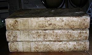
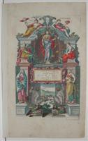
Atlantis majoris quinta pars, orbem maritimum seu omnium marium totius orbis terrarum navigationibus hodierno tempore frequentatorum descripti-onem accuratissimam continens; cui adjunctus est orbis antiquus & Graeciae parallela.
Editore: Joannes Janssonius, 1652
Da: Arader Galleries - AraderNYC, New York, NY, U.S.A.
Valutazione del venditore 5 su 5 stelle
Hardcover. Condizione: Very Good. 2nd Edition. Folio (19 5/8 x 12 6/8 inches). Engraved historiated title-page, with contemporary hand-colour HEIGHTENED IN GOLD. Double-page engraved anemometric table with FINE CONTEMPORARY HAND-COLOUR IN FULL (right-hand edge frayed, re-inforced on verso, and with short closed tear affecting the image) and 32 maps by Jansson, Peter Kaerius, J. Laurenberg, and others, all with FINE CONTEMPORARY HAND-COLOUR in outline and with the cartouches and other decorative elements colored in full (2D4 separated at the gutter). Contemporary gilt-panelled mottled calf, gilt edges (rebacked, with an early repair to the front cover). "THE FIRST SEA ATLAS (IN THE REAL SENSE OF THE WORD)" (Koeman). Second Latin text edition, first published in 1650 as the fifth volume of Jansson's "Novus atlas." "Orbem maritimum" was the "first sea atlas in the real sense of the word . a collection of charts in folio size, to serve as an atlas for general purposes" (Koeman). Three maps relate to North America: an important sea-chart of the northern Atlantic "Mar del Nort"; "Insularum Hispaniolae et Cuba" showing the importance of these islands to the Spanish; and "Mar del Zur Hispanis Mare Pacificum" the first sea chart of the Pacific region, depicting California as an island, and a small part of the Gulf of Carpentaria. Other maps that show the early Western Australian coastline include "Mar di India" and "Polus Antarcticus". Koeman Me 165; cf Martin Woods for "Mapping our World: Terra Incognita to Australia", National Library of Australia, page 157. Catalogued by Kate Hunter COMMENTARY from Graham Arader: This atlas shows "the organized maritime domination of the Dutch in the age of the Baroque. [It] shows that they were putting the towering profits they were making on cloves, mace, nutmeg and pepper back to work looking for other opportunities beyond the Spice Islands. During this time they established over 70 trading posts all over the world including NYC, Wilmington, Trenton and Newark.".
-
Nouveau Theatre du Monde ou Nouvel Atlas comprenant les tables et descriptions de toutes les regions de la terre.
Editore: Amsterdam: Joannes Janssonius, 1641-39-41., 1641
Da: Arader Galleries - AraderNYC, New York, NY, U.S.A.
Valutazione del venditore 5 su 5 stelle
Hardcover. 3 volumes. Folio (19 3/8 x 12 2/8 inches). Three fine hand-coloured engraved title-pages, those to volumes one and II HEIGHTENED IN GOLD (title-page to volume III and index leaf of volume II restored). 319 fine double-page engraved maps, hand-coloured in outline, a few with cartouches HEIGHTENED IN GOLD, woodcut illustrations and tailpieces (light discolouration and browning particularly to margins, some offsetting, several other leaves with margins strengthened, occasional clean tears, some early repairs). FINE 18th-century Italian mottled vellum, all edges gilt (extremities a bit rubbed). A rare and attractive set of the 3 volume French edition of Jansson's "Atlas Novus". The set collates as follows: volume I, Koeman II Me97B, 109 maps; volume II, a variant of 92B with 98 rather than 99 maps, and with the title-page and address not on overslips, probably an intermediate state between 92A and 92B; volume III, 112 maps, a variant of Me 39B with the date on the title-page altered to 1641. By 1638 Jansson had taken control of the publishing firm begun by his father-in-law Jodocus Hondius, and issued his "Atlas Novus", a completely new work although based on the work of Mercator. He expanded the atlas to three volumes in competition with Blaeu, it was a great success and published long after Jansson's death in 1664. Catalogued by Kate Hunter.
-

Atlas, or A Geographicke description of the Regions, Countries and Kingdomes of the world, through Europe, Asia, Africa, and America. Translated by Henry Hexham.
Editore: Amsterdam: H. Hondius and J. Jansonnius, 1636., 1636
Da: Arader Galleries - AraderNYC, New York, NY, U.S.A.
Valutazione del venditore 5 su 5 stelle
Prima edizione
Hardcover. Condizione: Very Good. 1st Edition. Volume one, only (of 2). Folio (18 6/8 x 12 inches). Engraved title-page with letterpress overslips to the title and imprint, magnificent double-page engraved portrait of Mercator and Hondius, 81 engraved maps, including a fine example of Hondius' double-hemisphere world map (Shirley 336, state 1), six maps with amateur hand-colour in outline (map of Denmark with a repaired marginal tear, map of Prussia with frayed right hand edge). Modern half vellum marbled paper boards. Volume one only of the first English-language edition of Henricus Hondius and Joannes Janssonius's revision of Mercator's atlas, published in 1630 as a response to the growing threat of their competitor Willem Blaeu. The only atlas of the world to appear in English since the publication of Abraham Ortelius' "Theatrum Orbis Terrarum. The Theatre of the Whole World", published by John Norton in 1606. Each map is accompanied by descriptive text, bringing the glories of Charles I's empire, before it was torn apart by the Civil War, to a wider audience in a language that they could read. The wonderful double-hemisphere world map "is a fine ornate example of the decorative cartography of the time. The two hemispheres are bordered by voluptuous representations of the four elements and other scenes: in the top corners are portraits of Julius Caesar and Claudius Ptolemy and in the bottom corners are portraits of the author's father Jodocus Hondius and his mentor Gerard Mercator. For geographical detail Hondius has followed Speed and his contemporaries and also presents California as an island. New features include part of the north Australia coastline extending towards New Guinea and a redrawing of north-east Canada with 'Queen Anne's forland' (Baffin Island) shown completely circled by open water." (Shirley 336). The Hondius-Jansson world map was included in all issues of the Mercator atlas from 1633 to about 1658. Maps that relate to America include the world map, and the Poli Arctici, other maps are of England, Ireland, Scotland, northwest Europe and Greece. "Jodocus Hondius obtained the copper-plates of Mercator's atlases (Ptolemy's "Geographia" and the "Atlas") on 12 July 1604. He probably bought them at Leiden at the auction of Mercator's library, then in the possession of his grandson, Gerard Mercator, Jr. A partly new text to the maps was written by Petrus Montanus. after [Jodocus Hondius's] death, the widow with her seven children continued publishing the atlases under the name of Jodocus Hondius till 1620. The firm was reinforced by the very welcome help of Joannes Jansonius (1588-1664), who married 24-year-old Elizabeth Hondius in 1612. After 1619 the Atlas was published under the name of Henricus Hondius [Jodocus Hondius's son] (Koeman). Koeman II, Me 41a; Phillips Atlases 449.
-
Atlantis Majoris Quinta Pars, Orbem Maritimum Seu Omnium Marium Totius Orbis Terrarum (?d.1657)
Da: PBShop.store UK, Fairford, GLOS, Regno Unito
Valutazione del venditore 5 su 5 stelle
EUR 25,14
Spedizione EUR 5,81
Spedito da Regno Unito a U.S.A.Quantit�: Pi� di 20 disponibili
Aggiungi al carrelloPAP. Condizione: New. New Book. Delivered from our UK warehouse in 4 to 14 business days. THIS BOOK IS PRINTED ON DEMAND. Established seller since 2000.
-
Carte de "L?�VESCH� D'AIRE" trac� par le Sieur Pierre du Val, secr�taire de Monseigneur l?�vesque d?Aire [circa 1680]
Lingua: Francese
Editore: JANSSONIUS Joannes, Amsterdam, 1658
Da: Librairie Guimard, Nantes, Francia
Valutazione del venditore 4 su 5 stelle
EUR 450,00
Spedizione EUR 30,00
Spedito da Francia a U.S.A.Quantit�: 1 disponibili
Aggiungi al carrelloCondizione: en tr�s bon �tat. DUVAL Pierre Amsterdam JANSSONIUS Joannes 1658 une carte ancienne grav�e sur cuivre (Copper etching) en noir et couleurs d'Epoque. Format : 44,5 cm de haut x 55 cm de large, pli central vertical normal venant d'un atlas( horizontal centerfold), texte en latin au verso, carte orn�e de 4 cartouches richement orn�s de 20 angelots et d'un paysan entrain de ramasser des pommes. carte double page grav�e et color�e � la main d'�poque, provenance : "Atlas novus, sive theatrum orbis terrarum : In quo Galliae, Helvetiae(Volume II)", 1658 Amsterdam JANSSONIUS Joannes Editeur, en tr�s bon �tat Tr�s belle carte peinte � l'�poque.ref : Koeman Me 67. TR�S RARE . en tr�s bon �tat (very good condition).
-

carte g�ographique Artesia Comitatus, ARTOIS
Lingua: Francese
Data di pubblicazione: 1653
Da: Librairie Les Fleurs du mal, N�mes, Francia
Valutazione del venditore 2 su 5 stelle

Mappa
EUR 90,00
Spedizione EUR 15,00
Spedito da Francia a U.S.A.Quantit�: 1 disponibili
Aggiungi al carrelloPas de couverture. Condizione: Tr�s bon. Carte in plano (55 X 42,5 cm). Beau cartouche soutenu par des anges ail�s avc les armes de l'artois. Au dos texte en espagnol de l'ouvrage "Nuevo Atlas, o Teatro de Todo el Mundo de Juan Janssonio en el qual con gran Cuydado Se Proponen los Mapas y Descripciones de Todo el Universo,".
-
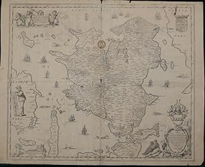
NAVARRA.
Editore: Ed. Joannis Janssony. Amstelodami, s.a. (c.1650, 1650
Da: FARR� Libreria Anticuaria, Barcelona, B, Spagna
Membro dell'associazione: AILA ILAB
Valutazione del venditore 5 su 5 stelle
EUR 210,00
Spedizione EUR 20,00
Spedito da Spagna a U.S.A.Quantit�: 1 disponibili
Aggiungi al carrello). 53 x 59,5 cm. M�nima rasgadura. Navarra.
-
Denmark: "Selandi� In Regno Dani� Insul� Chorographica Descriptio"
Editore: Joannes Janssonius, Amsterdam, 1645
Da: Crouch Rare Books, Godalming, Regno Unito
Valutazione del venditore 5 su 5 stelle
Mappa
EUR 222,97
Spedizione EUR 24,31
Spedito da Regno Unito a U.S.A.Quantit�: 1 disponibili
Aggiungi al carrelloCondizione: Fair (see description). copper engraved map, 44.5 cms (17.5 ins) x 53 cms (21 ins), uncoloured, a detailed study of the Danish Region of Sjaellanda with Kiobenhafven (Kopenhaven) on the east and Fionae (Fyn) on West, central fold as issued and an additional lateral central fold, ownership stamp, a few pinprick holes, a couple of larger holes and splits along folds in places, marginal nicks etc in places, some light pencil lines, Overall fair condition for age. This is an original antique map. We do not sell reproductions or facsimiles.
-
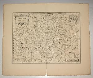
Original Engraved Antique Map of Nassovia Comitatus (County of Nassau.) Map shows Nordrhein-Westfalen with Siegen Rheinlandpfalz with Koblenz and Hessen with Wiesbaden.
Editore: Amsterdam No date 1650, 1650
Da: PROCTOR / THE ANTIQUE MAP & BOOKSHOP, DORCHESTER, Regno Unito
Membro dell'associazione: PBFA
Valutazione del venditore 5 su 5 stelle
EUR 230,13
Spedizione EUR 23,15
Spedito da Regno Unito a U.S.A.Quantit�: 1 disponibili
Aggiungi al carrelloUnmounted. Size 21 x 25 inches. Decorative Antique map With two orig. ornamental cartouches and large orig. Coat of arms. Shows Westerwald and Taunus with the Lahn river area (from Lollar to Lahnstein) in the center. In very good condition. A few faint marks on margins, and a couple of slight nicks. Inch split lower centre fold margin. Uncoloured,
-
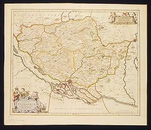
Tabula Geagraphica. Ducatus Stormariae. Tabula Geagraphica novissima Ducatus Stormariae in Meridionali parte Holsatiae.
Editore: Amsterdam, 1658
Da: Shapero Rare Books, London, Regno Unito
Membro dell'associazione: ABA ILAB PBFA
Valutazione del venditore 5 su 5 stelle
Mappa
EUR 298,09
Spedizione EUR 17,36
Spedito da Regno Unito a U.S.A.Quantit�: 1 disponibili
Aggiungi al carrelloDouble-page, engraved with fine original hand-colour. Attractive map by Jansson, showing the southern Duchy of Holstein in northern Germany. Central to the map is the historically important Hanseatic port of Hamburg. Decorative, rococo style embellishments complement this delightful map. 437 x 540 mm (17.25 x 21.25 inches). Koeman 1:428.1 (28c).
-
Lionnois, Forest, Beaviolois et Masconnois.
Editore: c.1640, Amsterdam, 1640
Da: Alexandre Antique Prints, Maps & Books, Toronto, ON, Canada
Membro dell'associazione: ABAC ILAB
Valutazione del venditore 4 su 5 stelle
Mappa
EUR 335,17
Spedizione EUR 5,21
Spedito da Canada a U.S.A.Quantit�: 1 disponibili
Aggiungi al carrelloCondizione: Very Good; Size : 372x488 (mm), 14.65x19.21 (Inches), Original Hand Coloring.
-
Bohemia
Editore: Amsterdam, 1657
Da: Alexandre Antique Prints, Maps & Books, Toronto, ON, Canada
Membro dell'associazione: ABAC ILAB
Valutazione del venditore 4 su 5 stelle
Mappa
EUR 335,17
Spedizione EUR 5,21
Spedito da Canada a U.S.A.Quantit�: 1 disponibili
Aggiungi al carrelloSize : 400x460 (mm), 15.75x18.125 (Inches), Hand Colored Very Good; central fold reinforced.
-
Theatrum Exhibens Celebriores Galliae et Heelvetiae Urbes
Editore: Amsterdam, 1620
Da: Alexandre Antique Prints, Maps & Books, Toronto, ON, Canada
Membro dell'associazione: ABAC ILAB
Valutazione del venditore 4 su 5 stelle
Mappa
EUR 357,52
Spedizione EUR 5,21
Spedito da Canada a U.S.A.Quantit�: 1 disponibili
Aggiungi al carrelloSize : 365x232 (mm), 14.375x9.125 (Inches), Original Hand Coloring Very Good; occasional browning spots; left margin extended.
-
Lumen Historiarum per Occidentem.
Editore: Amsterdam,, 1640
Da: libreria antiquaria perini Sas di Perini, Verona, VR, Italia
Membro dell'associazione: ALAI ILAB
Valutazione del venditore 5 su 5 stelle
Arte / Stampa / Poster
EUR 330,00
Spedizione EUR 40,00
Spedito da Italia a U.S.A.Quantit�: 1 disponibili
Aggiungi al carrelloIncisione in rame, colorata ai confini, di mm 385x485. Tratta dal volume di geografia del mondo antico di Hoornius. Raffigura l'Europa antica. Buon esemplare, lavato, con cospicui restauri visibili in controluce.
-

Territorio Trevigiano
Editore: Amsterdam, 1640
Da: libreria antiquaria perini Sas di Perini, Verona, VR, Italia
Membro dell'associazione: ALAI ILAB
Valutazione del venditore 5 su 5 stelle
Arte / Stampa / Poster
EUR 350,00
Spedizione EUR 40,00
Spedito da Italia a U.S.A.Quantit�: 1 disponibili
Aggiungi al carrelloIncisione in rame colorata d'epoca e rinfrescata, mm 385x500. Elegante carta eseguita sull'originale di Magini. Ottimo esemplare. Janssonius, genero di Jodocus Hondius e cognato di Henricus, collabor� alla pubblicazione di atlanti, dopo l'acquisizione delle lastre di Mercatore da parte di Jodocus e dal 1638 fu in effetti colui che guid� l'impresa editoriale, mentre Henricus Hondius lentamente abbandonava l'attivit? (dal 1646 il suo nome non apparir? pi? su alcun frontespizio); risult� cos� divenire il grande avversario della famiglia Blaeu nel secolo d'oro della cartografia olandese. Buon esemplare con qualche brunitura e stampa in controparte, alcuni restauri a fratture dovute all'ossidazione di colore, al verso alcuni rinforzi in cartacina in concomitanza di bruniture di colore ossidate. Nr.cat: Cod 4571.
-
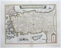
Natolia, quae olim Asia Minor.
Editore: Amsterdam, 1620
Da: Alexandre Antique Prints, Maps & Books, Toronto, ON, Canada
Membro dell'associazione: ABAC ILAB
Valutazione del venditore 4 su 5 stelle
Mappa
EUR 424,55
Spedizione EUR 5,21
Spedito da Canada a U.S.A.Quantit�: 1 disponibili
Aggiungi al carrelloCondizione: Very Good; fold reinforced. Size : 388x503 (mm), 15.25x19.75 (Inches), Hand Colored.
-
Nova et accurata Tusciae antique descriptio autore Ab. Ortelio
Editore: Amsterdam, 1650
Da: libreria antiquaria perini Sas di Perini, Verona, VR, Italia
Membro dell'associazione: ALAI ILAB
Valutazione del venditore 5 su 5 stelle
Arte / Stampa / Poster
EUR 380,00
Spedizione EUR 40,00
Spedito da Italia a U.S.A.Quantit�: 1 disponibili
Aggiungi al carrelloIncisione in rame, dipinta a mano, incisa da Petrus Kaerius, mm 350x494. La prima edizione a stampa fu realizzata da Abraham Ortelius per il suo Parergon, il primo atlante storico mai concepito; successivamente una nuova lastra venne preparata da Janszon ed inserita nel volume del mondo antico (vol. VI) del suo Atlas Major e poi in "Accuratissima Orbis Antiqui Delineatio" col testo di G. Hornius, stampato come volume singolo. Ottime condizioni generali, ampi margini e lieve ingiallimento della carta.Janssonius, genero di Jodocus Hondius e cognato di Henricus Hondius, figlio di Jodocus, collabor� alla pubblicazione di atlanti, dopo l'acquisizione delle lastre di Mercatore da parte di Jodocus e dal 1638 fu in effetti colui che guid� l'impresa editoriale, mentre Henricus Hondius lentamente abbandonava l'attivit? (dal 1646 il suo nome non apparir? pi? su alcun frontespizio); divenne cos� il grande avversario della famiglia Blaeu nel secolo d'oro della cartografia olandese. Georg Horn fu un erudito tedesco, autore di numerose opere storiche, fra cui anche del testo per l'atlante storico di Janssonius. Nr.cat: 4667.
-

Chili
Editore: Amsterdam, 1640
Da: libreria antiquaria perini Sas di Perini, Verona, VR, Italia
Membro dell'associazione: ALAI ILAB
Valutazione del venditore 5 su 5 stelle
Arte / Stampa / Poster
EUR 400,00
Spedizione EUR 40,00
Spedito da Italia a U.S.A.Quantit�: 1 disponibili
Aggiungi al carrelloIncisione in rame, dipinta d�epoca, mm 375x485. Piacevole carta del Cile arrichita da cartigli, rose dei venti e vascelli. Janssonius, dopo un periodo seguito all�acquisizione delle lastre di Mercatore da parte di Henricus Hondius dal padre Jodocus, fu colui che guid� l�impresa editoriale, dal 1646, quando il nome di Hondius non apparir? pi? su alcun frontespizio, sostituito sempre da quello di Janssonius; la societ? fra Hondius e Janssonius era stata il grande avversario della famiglia Blaeu nel secolo d�oro della cartografia olandese, ma Janssonius svilupp� ulteriormente il suo Atlas Major in concorrenza coi fratelli Blaeus . Esemplare con foglio ossidato e qualche traccia di colore in controstampa, margine inferior un poco rifilato Nr.cat: Cod 2477.
-

Latium
Editore: Amsterdam, 1652
Da: libreria antiquaria perini Sas di Perini, Verona, VR, Italia
Membro dell'associazione: ALAI ILAB
Valutazione del venditore 5 su 5 stelle
Arte / Stampa / Poster
EUR 400,00
Spedizione EUR 40,00
Spedito da Italia a U.S.A.Quantit�: 1 disponibili
Aggiungi al carrelloIncisione in rame, mm 385x515, dipinta a mano. Piacevole carta del territorio del Lazio, compreso fra Tevere, Aniene e Liri, nella non comune edizione senza testo del 1652, arricchita da un bel cartiglio in basso. Tratta da "Accurata Orbis antiqui Delineatio" l'atlante storico, curato da Hornius ed inserito da Janssonius come volume VI del suo "Atlas Novus". La carta � una copia di quella originariamente edita da Ortelio nel "Parergon" del "Theatrum Orbis Terrarum". Janssonius, genero di Jodocus Hondius e cognato di Henricus, collabor� alla pubblicazione di atlanti, dopo l'acquisizione delle lastre di Mercatore da parte di Jodocus e dal 1638 fu in effetti colui che guid� l'impresa editoriale, mentre Henricus Hondius lentamente abbandonava l'attivit? (dal 1646 il suo nome non apparir? pi? su alcun frontespizio); risult� cos� divenire il grande avversario della famiglia Blaeu nel secolo d'oro della cartografia olandese. Perfetto esemplare marginosissimo. Nr.cat: Cod. 7184.