Importo totale (1 articolo articoli):
Destinazione ordine:

liebaux (26 risultati)
Vai alla pagina principale dei risultati di ricerca
Filtri di ricerca
Tipo di articolo
- Tutti i tipi di prodotto
- Libri (17)
- Riviste e Giornali (Nessun altro risultato corrispondente a questo perfezionamento)
- Fumetti (Nessun altro risultato corrispondente a questo perfezionamento)
- Spartiti (Nessun altro risultato corrispondente a questo perfezionamento)
- Arte, Stampe e Poster (7)
- Fotografie (Nessun altro risultato corrispondente a questo perfezionamento)
- Mappe (2)
- Manoscritti e Collezionismo cartaceo (Nessun altro risultato corrispondente a questo perfezionamento)
Condizioni Maggiori informazioni
- Nuovo (16)
- Come nuovo, Ottimo o Quasi ottimo (1)
- Molto buono o Buono (3)
- Discreto o Mediocre (Nessun altro risultato corrispondente a questo perfezionamento)
- Come descritto (6)
Legatura
Ulteriori caratteristiche
- Prima ed. (Nessun altro risultato corrispondente a questo perfezionamento)
- Copia autograf. (Nessun altro risultato corrispondente a questo perfezionamento)
- Sovracoperta (Nessun altro risultato corrispondente a questo perfezionamento)
- Con foto (14)
- Non Print on Demand (18)
Lingua (2)
Spedizione gratuita
Paese del venditore
Valutazione venditore
-

Comme une vie... qui s'en va (French Edition)
Da: California Books, Miami, FL, U.S.A.
Valutazione del venditore 4 su 5 stelle

EUR 19,00
Spedizione gratuita
Spedito in U.S.A.Quantit�: Pi� di 20 disponibili
Aggiungi al carrelloCondizione: New.
-

Le manuscrit inachev� (French Edition)
Da: California Books, Miami, FL, U.S.A.
Valutazione del venditore 4 su 5 stelle
EUR 28,04
Spedizione gratuita
Spedito in U.S.A.Quantit�: Pi� di 20 disponibili
Aggiungi al carrelloCondizione: New.
-

EUR 17,99
Spedizione gratuita
Spedito da Cipro a U.S.A.Quantit�: Pi� di 20 disponibili
Aggiungi al carrelloLoose Leaf. Condizione: New. Reproduction. Original title: Map of Brabant German: Karte von Brabant French: Carte de Brabant Spanish: Mapa de Brabante High-quality fine-art reproduction based on an original work from the Rijksmuseum. Creation period: 18th century (1705). Professionally printed on premium fine-art paper (Photo Matt Fibre) in size A5. The motif is printed with a white border (museum-style presentation). No.
-

EUR 17,99
Spedizione gratuita
Spedito da Cipro a U.S.A.Quantit�: Pi� di 20 disponibili
Aggiungi al carrelloLoose Leaf. Condizione: New. Reproduction. Original title: Map of Brabant German: Karte von Brabant French: Carte de Brabant Spanish: Mapa de Brabante High-quality fine-art reproduction based on an original work from the Rijksmuseum. Creation period: 18th century (1745). Professionally printed on premium fine-art paper (Photo Matt Fibre) in size A5. The motif is printed with a white border (museum-style presentation). No.
-

EUR 17,99
Spedizione gratuita
Spedito da Cipro a U.S.A.Quantit�: Pi� di 20 disponibili
Aggiungi al carrelloLoose Leaf. Condizione: New. Reproduction. Original title: Map of the county of Flanders German: Karte der Grafschaft Flandern French: Carte du comt� de Flandre Spanish: Mapa de la provincia de Flanders High-quality fine-art reproduction based on an original work from the Rijksmuseum. Creation period: 18th century (1704). Professionally printed on premium fine-art paper (Photo Matt Fibre) in size A5. The motif is printed with a white border (museum-style presentation). No.
-

Map of the Republic of the Seven United Netherlands, A5
Editore: Contentum Ltd., Larnaca, Cyprus
Arte / Stampa / Poster
EUR 17,99
Spedizione gratuita
Spedito da Cipro a U.S.A.Quantit�: Pi� di 20 disponibili
Aggiungi al carrelloLoose Leaf. Condizione: New. Reproduction. Original title: Map of the Republic of the Seven United Netherlands German: Karte der Republik der Sieben Vereinigten Niederlande French: Carte de la R�publique des Sept Pays-Bas Spanish: Mapa de la Rep�blica de los Siete Pa�ses Bajos Unidos High-quality fine-art reproduction based on an original work from the Rijksmuseum. Creation period: 18th century (1702). Professionally printed on premium fine-art paper (Photo Matt Fibre) in size A5. The motif is printed with a white border (museum-style presentation). No.
-

Map of the Battle of Landen, 1693, A5
Editore: Contentum Ltd., Larnaca, Cyprus
Arte / Stampa / Poster
EUR 17,99
Spedizione gratuita
Spedito da Cipro a U.S.A.Quantit�: Pi� di 20 disponibili
Aggiungi al carrelloLoose Leaf. Condizione: New. Reproduction. Original title: Map of the Battle of Landen, 1693 German: Karte der Schlacht von Landen, 1693 French: Carte de la bataille de Landen, 1693 Spanish: Mapa de la batalla de Landen, 1693 High-quality fine-art reproduction based on an original work from the Rijksmuseum. Creation period: 17th century (1693). Professionally printed on premium fine-art paper (Photo Matt Fibre) in size A5. The motif is printed with a white border (museum-style presentation). No.
-
Le manuscrit inachev?
Da: PBShop.store US, Wood Dale, IL, U.S.A.
Valutazione del venditore 5 su 5 stelle

EUR 26,74
Spedizione gratuita
Spedito in U.S.A.Quantit�: Pi� di 20 disponibili
Aggiungi al carrelloPAP. Condizione: New. New Book. Shipped from UK. THIS BOOK IS PRINTED ON DEMAND. Established seller since 2000.
-
HISTOIRE DE LA VIE ET DES MIRACLES DE JESUS-CHRIST, TIREE DE L'HISTOIRE DE L'ANCIEN & DU NOUVEAU TESTAMENT
Lingua: Francese
Editore: chez Emery p�re, Emery fils, Saugrain l'a�n�, Pierre Martin, Paris, 1720
Da: Librairie RAIMOND, Dourges, Francia
Valutazione del venditore 5 su 5 stelle
EUR 200,00
Spedizione EUR 20,00
Spedito da Francia a U.S.A.Quantit�: 1 disponibili
Aggiungi al carrelloCouverture rigide. Condizione: Assez bon. LIEBAUX (illustratore). R.P.D. Augustin CALMET, Abb� de S. Leopold de Nancy HISTOIRE DE LA VIE ET DES MIRACLES DE JESUS-CHRIST, TIREE DE L'HISTOIRE DE L'ANCIEN & DU NOUVEAU TESTAMENT 1720, Paris, Edition chez Emery p�re, Emery fils, Saugrain l'a�n�, Pierre Martin Format : In-12 (16,5 x 10 cm), reli�, LVIII-436 pages Reliure plein cuir strictement de l'�poque, dos � nerfs titr� sur pi�ce et orn� de caissons � fleurons or illustr� de 21 figures hors texte en taille douce ( 3 gravures sont absentes) et complet de la carte d�pliante de la Terre Sainte dress�e par LIEBAUX (restauration par adh�sif au verso), une figure in texte Etat : travail de vers en d�but d'ouvrage sans gravite, une coiffe aras�e, reliure �corch�e mais solide, agr�able volume poids : 480g.
-

Histoire Universelle, depuis le commencement du monde jusqu'a pr�sent. Tome 31. Contenant la suite de l'Histoire de France depuis le r�gne de Louis XII jusqu'au tems pr�sent
Editore: Amsterdam : Arkst�e & Merkus, 1769
~ Carte de la France (d�pliable), 1728, ou les limites du Royaume sont marqu�es suivant les Trait�s d'Utrecht, de Rastat et de Bade, conclus en 1713 et 1714, par Henri Li�baux, g�ographe ordinaire du Roi et censeur Royal ~ Veau marbr� d'�poque, dos � nerfs, caissons dor�s, titre dor� sur p.d.t. fauve, filet � froid autour des plats, tranches rouges, signet ~ IV+577p ~ 26x21x6cm. ~ Dos frott� et avec l�ger manque de cuir en haut et en bas, mors fragiles, mouillures claires pr�s du dos � l'int�rieur, d'ailleurs Tr�s Bon exemplaire ~ Heavy item, circa 1.3 Kg. Extra postage costs may apply (please ask for quotation before ordering, clicking on the "Contact seller" button to be found above) ~ LANGUAGE: Fran�ais / Additional images available/// We accept PayPal & EU bank transfer in EUROS //.
-
Carte de la Belgique pour servir � l'intelligence de l'Histoire Romaine et a celle des Conqu�tes de Cesar dans la Gaule.
Editore: S.A.S. Monseigneur le Comte de Clermont, 1730
Da: Versandantiquariat H�sl, Neuried, Germania
Valutazione del venditore 5 su 5 stelle
Mappa
EUR 65,00
Spedizione EUR 9,50
Spedito da Germania a U.S.A.Quantit�: 1 disponibili
Aggiungi al carrelloCondizione: Gut. Kupferstichkarte von Henri Li�baux mit der Darstellung von Belgien zur Zeit C�sars; sie zeigt die Siedlungsr�ume der gallischen und der angrenzenden germanischen St�mme. Aus Catrou & Rouille: Histoire Romaine depuis la fondation de Rome. Tome seizieme. Rolline, Delespine, Coignard, Paris 1730. Karte verlagsseitig mehrfach gefaltet, seitlicher Einriss ist von alter Hand mit Papier �berklebt (auf der Vorderseite kaum sichtbar); darauf handschriftl. Zahlennotiz Sprache / Language: fr 1 Seiten. ca. 25,4 x 31,7 cm.
-
Comme une vie. qui s'en va (French Edition)
Da: Majestic Books, Hounslow, Regno Unito
Valutazione del venditore 4 su 5 stelle
EUR 21,02
Spedizione EUR 7,53
Spedito da Regno Unito a U.S.A.Quantit�: 4 disponibili
Aggiungi al carrelloCondizione: New. Print on Demand.
-
Le manuscrit inachev?
Da: PBShop.store UK, Fairford, GLOS, Regno Unito
Valutazione del venditore 5 su 5 stelle
EUR 24,76
Spedizione EUR 4,82
Spedito da Regno Unito a U.S.A.Quantit�: Pi� di 20 disponibili
Aggiungi al carrelloPAP. Condizione: New. New Book. Delivered from our UK warehouse in 4 to 14 business days. THIS BOOK IS PRINTED ON DEMAND. Established seller since 2000.
-
Comme une vie. qui s'en va (French Edition)
Da: Books Puddle, New York, NY, U.S.A.
Valutazione del venditore 4 su 5 stelle
Condizione: New. Print on Demand.
-

Carte de la Belgique pour servir � l'intelligence de l'Histoire Romaine et a celle des Conqu�tes de Cesar dans la Gaule Li�baux g�ographe de S.A.S. Monseigneur le Comte de Clermont
Editore: s.n., s.n., 1730
Da: BACCHETTA GIORGIO - ALFEA RARE BOOKS, Milano, MI, Italia
Membro dell'associazione: ALAI ILAB
Valutazione del venditore 4 su 5 stelle
EUR 40,00
Spedizione EUR 42,00
Spedito da Italia a U.S.A.Quantit�: 1 disponibili
Aggiungi al carrelloVolume: 1 24,5x31,5 cm., su carta pesante, a colori, in francese, buone condizioni.
-
A L'Hippique. Profils et Silhouettes. Album. I.
Editore: H. Simonis Empis, Paris, 1902
Da: White Fox Rare Books and Antiques, ABAA/ILAB, New York, NY, U.S.A.
Membro dell'associazione: ABAA ESA ILAB PBFA
Valutazione del venditore 3 su 5 stelle

Folio Folder. Cloth Spine. Condizione: Very Good. Scarce large folio of equine caricature. Only copy located on OCLC is in the Bibliotheque Nationale de France. 56 by 39 cm. With 21 color plates of horses and their men, rendered in a style reminiscent (and inspired by) Sem. Images are big, bold yet also simple and precise. Depicted are coachmen, the mishap of a rider charging fences, gamblers at a racetrack, pleasure riders and hunters. Soiling to the binding. Ribbon tie gone. Some minor soiling on a few plates. One plate with edge chip not affecting image.
-
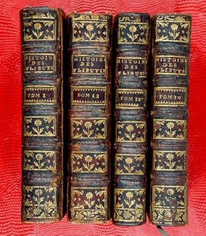
Histoire des Avanturiers Flibustiers qui se sont signalez dans les Indes ; Journal du Voyage Fait � la Mer du Sud ; Histoires des Pirates Anglois
Editore: Trevoux : Par la Compagnie, 1744
Rousset & Li�baux (illustratore). ~ 4 volumes ~ Frontispice au vol. I et 7 planches hors-texte d�pliables ~ GRAVURES (� l'exception du frontispice, toutes les gravures sont d�pliantes) : Vol. I : Un frontispice dat� 1743 ; Un boucanier, compl�t� en bas avec 3 petites gravures sur la fa�on de vivre des boucaniers (p. 11) ; Carte de l'embouchure du lac de Maracaibo (p. 177) ; Plan de Vera Cruz avec les Isles (sic) de St. Jean de Luz (p. 261) ; Pirogue espagnole (p. 311) ; Mani�re de p�cher la tortue, un lamantin, 3 cat�gories d'harpon (p.373) - Vol II : Carte de l'Isthme de Panama (p. 97) ; Plan de la ville de Cartag�ne (p. 317) ~ TITRES : Volumes 1 et 2: Histoire des Avanturiers Flibustiers qui se sont signalez dans les Indes, contenant ce qu'ils ont fait de remarquable, avec la Vie, les Moeurs, et les Coutumes des Boucaniers, & des Habitants de S. Domingue & de la Tortue; Une description exacte de ces lieux; Et un Etat des Offices tant Eccl�siastiques que S�culiers, & ce que les plus grands Princes de l'Europe y poss�dent. Le tout enrichi de Cartes G�ographiques & de Figures en Taille-douce. / Par Alexandre-Olivier Oexmelin - Nouvelle Edition Corrig�e & Augment�e de l'Histoire des Pirates Anglois depuis leur Etablissement dans l'Isle de la Providence jusqu'� pr�sent : Tome Premier (et Tome Second). A Trevoux, Par la Compagnie. MDCCXLIV. Volume 3 :Histoire des Avanturiers Flibustiers qui se sont signalez dans les Indes, contenant la Journal du Voyage Fait � la Mer du Sud. / Par le Sieur Raveneau de Lussan : Tome Troisi�me. - A Trevoux, Par la Compagnie. MDCCXLIV. Volume 4: Histoires des Pirates Anglois Depuis leur Etablissement dans l'Isle de la Providence jusqu'� pr�sent. Contenant toutes leurs Avantures, Pirateries, Meurtres, Cruant�s, Exc�s, etc. Avec La Vie et les Avantures De deux Femmes Pirates Marie Read & Anne Bonny. Et un Extrait des Loix & des Ordonnances concernant la Piraterie. / Traduite de l'Anglois. Du Capitaine Charles Johnson [Daniel Def�e] : Quatrieme Tome. - A Trevoux, Par la Compagnie. MDCCXLIV. Signatures: p1, a-a6, A-R12/6; p1, A-R12, S-S8, T-T2; p1, A-P12/6, [P6 b]; p1, a-a12, e-e12, i-i6, A-P12 [P12 b] ~ Veau marbr� d'�poque, dos � nerfs, caissons dor�s, pi�ces de titre et tomaisons rouges dor�s, tranches rouges ~ Tome I: frontis+[12]+394+[1]p+5 pl. d�pl. (p. 1, 177, 261, 311, 373); Tome II: titre+428p+2 pl. d�pl. (p. 97, 317); Tome III: titre+348p+1fb; Tome IV: titre+lX+356p+1fb. ~ 17x11x13cm. ~ Coins frott�s avec manque de cuir, 1 mors fendu au tome I, 1 coiffe absent au tome II, quelques nerfs l�g�rement frott�s, par ailleurs TR�S BON EXEMPLAIRE, L'INT�RIEUR TR�S FRAIS. Signature ancienne � l'encre sur les 4 titres ~ Heavy item, circa 1.4 Kg. Extra postage costs may apply (please ask for quotation before ordering, clicking on the "Contact seller" button to be found above) ~ LANGUAGE: Fran�ais / Additional images available/// We accept PayPal & EU bank transfer in EUROS //.
-
Comme une vie. qui s'en va (French Edition)
Da: Biblios, Frankfurt am main, HESSE, Germania
Valutazione del venditore 4 su 5 stelle
EUR 21,41
Spedizione EUR 9,95
Spedito da Germania a U.S.A.Quantit�: 4 disponibili
Aggiungi al carrelloCondizione: New. PRINT ON DEMAND.
-
CARTE DE LA TERRE, PROMISE dress�e par l'auteur du Commentaire sur Josus� et grav�e par Li�baux, g�ografe.
Editore: S.d. c. 1700, 1700
Da: FARR� Libreria Anticuaria, Barcelona, B, Spagna
Membro dell'associazione: AILA ILAB
Valutazione del venditore 5 su 5 stelle
EUR 130,00
Spedizione EUR 20,00
Spedito da Spagna a U.S.A.Quantit�: 1 disponibili
Aggiungi al carrello. 51,5 x 36 cm. Jerusalem . Israel.
-

L'Europe. Par De Fer.-
Editore: [Um 1700], 1700
Da: Antiquariat Tautenhahn, L�beck, Germania
Membro dell'associazione: GIAQ ILAB VDA
Valutazione del venditore 5 su 5 stelle
Arte / Stampa / Poster
EUR 90,00
Spedizione EUR 105,00
Spedito da Germania a U.S.A.Quantit�: 1 disponibili
Aggiungi al carrelloAlt-grenzkolorierter Kupferstich 13 x 16 cm, Blattgr��e 16 x 16,5 cm. Landkarte von Europa, gestochen von Liebaux. Die Titelkartusche mit einem mythologischen Motiv zum Thema Europa unten links. - Nicolas de Fer 1646 - 1720, Zeichner und Kupferstecher, Verleger von Atlanten, die 1693 - 1722 in Paris erschienen sind. - Das Papier gebr�unt, an den R�ndern leicht fingerfleckig. Der Druck sauber und kraftvoll.
-
Tabula Itineris Israelitarum per desertum ab exitu de Aegypto ad usque vadu Jordanis
Editore: (1742), 1742
Da: Old New York Book Shop, ABAA, Atlanta, GA, U.S.A.
Membro dell'associazione: ABAA ILAB
Valutazione del venditore 5 su 5 stelle
Map. Condizione: Near fine. 14" x 18" page with map and 10 vignettes surrounding it. Map of the Journey of the Israelites through the Desert from the exit of Egypt to the fords of Jordan, outlined by the Author of the Commentary on Exodus and first engraved by Liebaux the Geographer circa the 18th century. Near fine, faint crease along center.
-

In Notiam Ecclesiasticam Africae Tabula Geographica Auctore G. De L' Isle Christianissimi Francorum Regis Geographo primario Parisiis Apud Auctorem in Ripa vulgo dicta le Quai de l'Horologe Cum Privilegio Regis ad vicennium 1700.
Editore: Ph. Buache, Paris, 1745
Da: Antiquariat Reinhold Berg eK Inh. R.Berg, Regensburg, Germania
Membro dell'associazione: ILAB VDA
Valutazione del venditore 5 su 5 stelle
Mappa
EUR 220,00
Spedizione EUR 24,00
Spedito da Germania a U.S.A.Quantit�: 1 disponibili
Aggiungi al carrelloOther. Copper engraving, handcolored in outline, when published. Drawn and engraved by j.B. Liebaux after cartographic sources by Guil. de Isle. Ornated with a impressive title cartouche at the lower center, as well a decorative mileage scale and descriptive text. In excellent condition. 483 by 632mm (19 by 25 inches). 483 by 632mm (19 by 25 inches).
-
Le manuscrit inachev? (French Edition)
Da: Majestic Books, Hounslow, Regno Unito
Valutazione del venditore 4 su 5 stelle
EUR 33,87
Spedizione EUR 7,53
Spedito da Regno Unito a U.S.A.Quantit�: 4 disponibili
Aggiungi al carrelloCondizione: New. Print on Demand.
-
Le manuscrit inachev? (French Edition)
Da: Books Puddle, New York, NY, U.S.A.
Valutazione del venditore 4 su 5 stelle
Condizione: New. Print on Demand.
-
Le manuscrit inachev? (French Edition)
Da: Biblios, Frankfurt am main, HESSE, Germania
Valutazione del venditore 4 su 5 stelle
EUR 33,87
Spedizione EUR 9,95
Spedito da Germania a U.S.A.Quantit�: 4 disponibili
Aggiungi al carrelloCondizione: New. PRINT ON DEMAND.