Cluever philipp (99 risultati)

Editore: o.J. um 1660, 1660
- Mappa
Da: Versandantiquariat Hösl, Neuried, GermaniaVersandantiquariat Hösl
Contatta il venditoreVenditore con 5 stelleCondizione: Usato - Buono
EUR 20,00
EUR 9,50 spedizioneSpedito da Germania a U.S.A.Quantità: 1 disponibili
Condizione: Befriedigend. Karte aus Clüvers Werk 'Introductio in Universam Geographiam' ohne Jahr, um 1660. Dreigeteilte Darstellung mit der Tunesischen Küste, der Cyrenaica und der Hauptkarte Mauretanien. Die Karte ist mittig gefaltet, am linken Rand mit Knickspuren und einem starken Flüssigkeitsfleck am oberen Eck rechts. Spra…che / Language: la 1 Seiten. ca. 17,1 x 20,6 cm.

- Brossura
Da: PBShop.store US, Wood Dale, IL, U.S.A.PBShop.store US
Contatta il venditoreVenditore con 5 stelleCondizione: Nuovo
EUR 41,56
Spedizione gratuitaSpedito in U.S.A.Quantità: 15 disponibili
PAP. Condizione: New. New Book. Shipped from UK. Established seller since 2000.
- Brossura
Da: PBShop.store UK, Fairford, GLOS, Regno UnitoPBShop.store UK
Contatta il venditoreVenditore con 5 stelleCondizione: Nuovo
EUR 35,13
EUR 7,89 spedizioneSpedito da Regno Unito a U.S.A.Quantità: 15 disponibili
PAP. Condizione: New. New Book. Shipped from UK. Established seller since 2000.

Lingua: Tedesco
Editore: Nürnberg, 1680
- Mappa
Da: Antiquariat Steffen Völkel GmbH, Seubersdorf, GermaniaAntiquariat Steffen Völkel GmbH
Contatta il venditoreVenditore con 5 stelleCondizione: Usato
EUR 24,99
EUR 30,00 spedizioneSpedito da Germania a U.S.A.Quantità: 1 disponibili
Seltene Miniatur Kupferstich-Karte von Philip Clüver (1580-1622) von ca. 1680. -- Blatt-Maße: ca. 14 x 14 cm. -- gut erhalten. || Rare miniature copper engraved map by Philip Clüver (1580-1622) from c. 1680. -- in good condition. || Dies ist ein Original! - Kein Nachdruck! - Keine Kopie! -- This is an original! No copy! - No rep…rint! // Wir, das Antiquariat Steffen Völkel, kaufen und verkaufen alte Bücher, Handschriften, Zeichnungen, Autographen, Grafiken und Fotografien. Wir sind stets am Ankauf von kompletten Bibliotheken, Sammlungen und Nachlässen interessiert. Sprache: Deutsch Gewicht in Gramm: 10.

Lingua: Inglese
Editore: Germany, 1661
Da: Hornseys, Ripon, Regno UnitoHornseys
Contatta il venditoreVenditore con 5 stelleMembro dell’associazione: PBFA
Condizione: Usato - Molto buono
EUR 300,59
EUR 29,18 spedizioneSpedito da Regno Unito a U.S.A.Quantità: 1 disponibili
No Binding. Condizione: Very Good. California is shown as a large island, the north-west coast of America is not identified and none of the Great Lakes are visible. New Zealand is shown as a single coastline. Published in Leiden. Date:1661. Edition identified by 'pag. 666' in the top right hand corner. Sheet Size: 37.7cm x 25cm.… Original fold lines. Very minor age-spots. Age-toning to the paper. Reverse is blank with age toning and minor marks. In very good condition overall. Location: Map Drawer C: FS: Folder M2000 002546.
 Altre immagini
Philippi Cluverii Introductio in universam geographiam tam veterem quam novam. Tabulis geographicis XLVI ac notis olim ornata a Johanne Bunone, jam vero locupletata additamentis & annotationibus Joh. Frid. Hekelii & Joh. Reiskii. Cum privilegio ordinum Ho
Clüver, Philippe [Philipp Cluverius / Cluvier] - Buno, Johann ; Reiske, Johann ; Heckel, Johann Friedrich
Lingua: Francese
Editore: Jean Wolters, Amsterdam, 1697
- Rilegato
- Prima edizione
Da: Des livres autour (Julien Mannoni), Paris, PARIS, FranciaDes livres autour (Julien Mannoni)
Contatta il venditoreVenditore con 4 stelleCondizione: Usato - Quasi ottimo
EUR 2200,00
EUR 45,00 spedizioneSpedito da Francia a U.S.A.Quantità: 1 disponibili
Plein Vélin. Condizione: Bon. First Thus. Amsterdam [Amstelaedami], Jean Wolters [Joannem Wolters], 1697. 24 x 18 cm (R), in-4, 1 f. bl. - titre frontispice entièrement gravé - 11 ff. n. ch. (dont titre, dédicace, adresse au lecteur, epistolae, table et privilège) - 565 pp. - 31 ff. n. ch. d'index - 2 ff. bl. - 2 planches, 3 tab…leaux et 41 (sur 43) cartes gravées hors texte, dont 40 sont dépliantes ou à double page, reliure hollandaise de l'époque en plein vélin doré, plats estampés à froid de motifs des Pays Bas espagnols dans un double encadrement de filets avec fleurons d'angle, dos estampé de filets et fleurons, titre manuscrit à l'époque, traces de lacets. (sig. *3, **4, ***4, A-Z4, Aa-Zz4, Aaa-Zzz4, Aaaa-Kkkk4) Belle édition de la fin du XVIIeme du célèbre atlas de Clüver, avec les commentaires de Buno, Reiske et Heckel, intéressante notamment parce qu'elle est au format in-4 et non in-8 ou in-12, comme la plupart des autres. Un bel ex-dono, daté de 1725 et couvrant tout le premier feuillet blanc, nous indique qu'il s'agit d'un livre de prix. Cachets annulés d'une bibliothèque de capucins au titre. Sans la mappemonde et la carte l'Amérique. Exemplaire très légèrement déréglé, ce qui est courant pour un volume de cette taille, une carte détachée, pour le reste un fort bel exemplaire exempt de rousseurs et dans une belle reliure estampée de l'époque. dv.
 Altre immagini
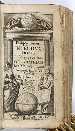
Editore: Venice, Balleoni, 1674., 1674
- Rilegato
Da: Antiquariat INLIBRIS Gilhofer Nfg. GmbH, Vienna, A, AustriaAntiquariat INLIBRIS Gilhofer Nfg. GmbH
Contatta il venditoreVenditore con 5 stelleCondizione: Usato
EUR 120,00
EUR 30,00 spedizioneSpedito da Austria a U.S.A.Quantità: 1 disponibili
12mo (56 x 105 mm). 465, (11) pp. Engraved title-page. With a letterpress folding table; a folding plate is missing. Contemporary leather binding. Uncommon pocket-sized edition of Clüver's popular geographic history, edited by Joseph Vorstius and first published in Leiden in 1624. Long considered a standard work, it was later is…sued with maps. The text describes all the countries of the world, including a section on America and the islands of the "New World" (book 6, chapters 11 ff.). Book 5, chapter 24 (pp. 341 ff.) discusses Arabia, chapter 15 (pp. 315 f.) deals with the Kingdom of Ormuz. - Some worming to spine. Interior a little wrinkled throughout; light edge flaws to index at the end; an engraved plate after p. 30 has been torn out. Stamp of the L'achki collection on lower pastedown. A working copy. - OCLC 634555324.

DER ATLAS DES PRINZEN EUGEN. - Originalgetreue Faksimile-Reproduktionen aus dem 'ATLAS BLAEU - Van der Hem'(Amsterdam 1662-1678) der Österreichischen Nationalbibliothek, Band 1: SCHWEIZER STÄDTE- UND LANDSCHAFTSBILDER IN ILLUMINIERTEN KUPFERSTICHEN DES 17. JAHRHUNDERTS. - 35 Ansichten und 8 Kartenblätter; mit einem wissenschaftlichen Kommentar von Robert Wagner. [Helvetia, quae est Europae Liber XV.]
Eugen Franz, Prinz von Savoyen-Carignan (1663-1736; einer der bedeutendsten Feldherren der Habsburgermonarchie, ab 1697 Oberbefehlshaber im Großen Türkenkrieg, während des Spanischen Erbfolgekrieges, 1701-1714, Oberkommandierender der antifranzösischen Allianz, Präsident des Hofkriegsrats und Diplomat, als Bauherr und Kunstsammler einer der bedeutendsten Mäzene seiner Zeit; hier Auftrags- und Namensgeber) / Robert Wagner (*1943 in Wien; Historiker, leitete von 1982 bis 2004 die Bibliothek und das Kupferstichkabinett der Akademie der bildenden Künste in Wien; Kommentar) / Joan Blaeu; Willem Jansz. Blaeu; Philipp Clüver; Johann Leopold Cysat; Fortunat Sprecher. . .; Jacques Goulart; Johannes Janssonius; Martin Martini; Gerard Mercator; Caspar Merian; Matthäus Merian; Hans Caspar Nüscheler; Pierre du Val d'Abbéville; Josef Plepp; Jean Poinssart; Hans Heinrich Thomann; Johann Jacob Ziegler (Kartographen und Kupferstecher):
Editore: Graz, Akademische Druck- und Verlagsanstalt / ADEVA, 1979., 1979
- Rilegato
Da: C O - L I B R I , Bremen - Berlin ; Deutschland / Germany ., Berlin, GermaniaC O - L I B R I , Bremen - Berlin ; Deutschland / Germany .
Contatta il venditoreVenditore con 5 stelleCondizione: Usato
EUR 235,00
EUR 45,00 spedizioneSpedito da Germania a U.S.A.Quantità: 1 disponibili
67 (1) Seiten Text, 43 einseitig bedruckte tls. doppelblattgroße Farbtafeln mit zwischenliegenden Seidenschutzblättern; alles auf kräftigem hochwertig strukturiertem Papier. - Schwerer, reich vergoldeter weißer Original-Ledereinband - wohl - auf Holzdeckeln und über 8 erhabene Bünde mit goldgeprägtem Rückentitel; imperial-Folio…(ca. 59,5 x 40 x 4 cm; ca. 6,2 kg.). *** [Verlängerter FRÜHSOMMER-VERKAUF / Ongoing EARLY SUMMER-SALE: um über 20% REDUZIERTER PREIS bis Donnerstag, 09.07.2026 / PRICE-REDUCTION of over 20% until Thursday, July 09; vorheriger Preis / previously EUR 300,-] --- 1. AUFLAGE, ÜBERGROSSFORMATIGE BIBLIOPHIL GEBUNDENE AUSGABE; Nr. CCXXXII (#232) von 1.000 Exemplaren der Gesamtauflage (noch mit beiliegendem signierten Qualitätsprüfzettel). - Vorderdeckel am Rand etwas stockfleckig-, Hinterdeckel nur am Rand der unteren Innenkante; Vorderdeckel auch mit kleiner Bereibung und kleinem oberflächlichen Lederabrieb (ca. 5x5 mm); innen tadellos und mit allen Seidenschutzblättern. --- DER TEXTTEIL ENTHÄLT DIE KAPITEL 'Der Atlas des Prinzen Eugen von Savoyen, oder >Atlas Blaeu - Van der Hem<.'; 'Der Initiator: Laurens Van der Hem.'; 'Spiritus Rector: Joan Blaeu.'; 'Der Illuminator: Dirck Jansz. van Santen.'; 'Der Bibliophile: Prinz Eugen von Savoyen.'; 'Die Städte- und Landschaftsbilder: Matthäus Merian und seine Grosse Topographie.'; 'Die Schweiz im Atlas des Prinzen Eugen von Savoyen.'; 'Übersicht aller Bände des Atlas . . .'; 'Literatur.'; 'Die Tafeln: Verzeichnis der Tafeln.'; 'Die illuminierten Kupferstiche aus Band 13 (Schweiz) im Atlas . . . / Illuminierte Schweizer Kupferstiche aus anderen Bänden des Atlas . . .'; DIE MONTIERTEN FARBTAFELN AUF HALBMATTEM KUNSTDRUCKPAPIER ZEIGEN die 'Schweiz.'(Johannes Janssonius); das 'Rheintal oberhalb Chur, Graubünden.'(Caspar Merian)*; den 'Rheinfall bei Schaffhausen.'(Matthäus Merian)**; 'Rhein bei Kadelburg, Aargau.'(**); 'Grüningen, Zürich.'(Hans Heinrich Thomann/**); 'Regensberg, Zürich.'(Johann Jacob Ziegler/**); 'Zürichgau und Basel'(Gerard Mercator/Willem Jansz. Blaeu)***; 'Zürich.'(Hans Caspar Nüscheler/**); 'Breitenlandenberg, Zürich.'(*); 'Einsiedeln, Schwyz.'(**); 'Leuk, Wallis.'(*); 'Sempach, Luzern.'(**); 'Baden, Aargau.'(**); 'Wiflisburgergau.'(***); 'Grindelwaldgletscher, Bern.'(Josef Plepp/**)****; 'Paß Pierre Pertuis.'(****); 'Lenzburg, Aargau.'(****); 'Neuenburg/Neuchâtel.'(**); 'Aargau.'(***); 'Vierwaldstätter See.'(Johann Leopold Cysat/*); 'Luzern.'(Martin Martini/**); 'Altdorf, Uri.'(**); 'Thun.'(**); 'Schwyz.'(*); 'Bad Pfäfers, St. Gallen.'(**); 'Unterwalden.'(**); 'Basel.'(**); 'Rheinbrücke und Münster in Basel.'(**); 'Münchenstein, Basel Land.'(**); 'Basel und Umgebung.'(Joan Blaeu); 'Graubünden.'(Fortunat Sprecher. . . und Philipp Clüver/W.J. Blaeu); 'Chur, Graubünden.'(**); 'Wallis.'(Pierre du Val d'Abbéville); 'Saint-Maurice/[St. Moritz], Wallis.'(*); 'Brig und Naters, Wallis.'(*); 'Lugano, Tessin.'(**); 'Bellinzona, Tessin.'(**); 'Engelberg, Unterwalden ob dem Wald.'(*); 'Landschaft um Bad Pfäfers, St. Gallen.'(*); 'Visp, Wallis.'(*); 'Genfer See.'(Jacques Goulart/W. J. Blaeu); 'Genf/Genève.'(Jean Poinssart); 'Tarasp, Graubünden.'(*).
 Altre immagini
Editore: Guelpherbyti: Impensis CONRADI BUNONIS, TYPIS JOHANNIS BISMARCI., 1661
- Rilegato
Da: Louis88Books (Members of the PBFA), Andover, Regno UnitoLouis88Books (Members of the PBFA)
Contatta il venditoreVenditore con 5 stelleMembro dell’associazione: PBFA
Condizione: Usato - Buono
EUR 360,71
EUR 33,85 spedizioneSpedito da Regno Unito a U.S.A.Quantità: 1 disponibili
Hardcover. Condizione: Good. Guelpherbyti: Impensis CONRADI BUNONIS, TYPIS JOHANNIS BISMARCI, 1661, Later Edition. Full vellum binding, ink manuscript titles to the spine, limp vellum, worn and marked, ink marginalia and colour underlining throughout. With 3 (I, II and III) of the illustrations and 2 folding tables (see photos)…only. Pagination: [xxx], 632, [68]pp. Provenance: ex library with 2 stamps to the title page. Approximately 7 ½ inches (19.5cm) tall. Condition Report Externally Spine good condition rubbed and worn, ink titles marked. Joints good condition sound, rubbed and worn. Corners good condition rubbed and bumped. Boards good condition full limp vellum, marked and worn. Page edges good condition all edges tanned and darkened. Binding good condition sound. See above and photos. Internally Hinges good condition sound. Paste downs good condition tanned paper, ink and other manuscript notes. End papers good condition lacking to the front, tanned paper, ink and other manuscript notes at the rear. Title good condition tanned and marked, 2 stamps. Pages good condition tanned with some foxing and damp staining. See photos.
Editore: Cluever Philipp, 1580-1622, 1622
- Rilegato
Da: Hammelburger Antiquariat, Hammelburg, GermaniaHammelburger Antiquariat
Contatta il venditoreVenditore con 5 stelleCondizione: Usato - Molto buono
EUR 350,00
EUR 30,00 spedizioneSpedito da Germania a U.S.A.Quantità: 1 disponibili
Hardcover. Condizione: very good. Philippi Cluverii? Introductio in omnem geographiam veterem aeque ac novam Contributor: Clüver, Philipp (1580-1622) Buno, Johannes (1617-1697) Reiske, Johann (1641-1701) Published: Wolfenbüttelae : Buno, 1694 Language: Latein Extent: 608 S. Orig. geprägter Schweinsledereinband, gebräunt, stockfl…eckig.

Editore: Leyden, Elzevir, 1641
- Rilegato
Da: EOS Buchantiquariat Benz, Zürich, SvizzeraEOS Buchantiquariat Benz
Contatta il venditoreVenditore con 4 stelleCondizione: Usato
EUR 392,43
EUR 25,00 spedizioneSpedito da Svizzera a U.S.A.Quantità: 1 disponibili
12°. 352 S.; 70, (9) S. Mit 1 gest. Titel und 5 gef. Tafeln. Lederband der Zeit mit Rückenvergoldung und Rückenschild. Willems 513. - Mit drei Exlibris. Einband leicht berieben und mit kleineren Fehlstellen am Rücken. Die Buntpapiervorsätze fleckig. + Wichtig: Für unsere Kunden in der EU erfolgt der Versand alle 14 Tage verzollt… ab Deutschland / Postbank-Konto in Deutschland vorhanden +.
 Altre immagini
Editore: Guelferbyti: Buno; Wolfenbuttel, 1659
- Rilegato
Da: Sequitur Books, Boonsboro, MD, U.S.A.Sequitur Books
Contatta il venditoreVenditore con 5 stelleMembro dell’associazione: IOBA
Condizione: Usato - Discreto
EUR 558,24
EUR 4,34 spedizioneSpedito in U.S.A.Quantità: 1 disponibili
Hardcover. Condizione: Fair. 4to. 21 cm. Bound in contemporary calf. Spine ends chipped, front joint cracked. Solid binding. Wear to extremities. Substantial browning/toning to text. [12], 773 [i. e., 768], [44] pp. Engraved title. 4 folding engraved maps of Italy; folding bird's-eye view of Rome, at rear. Maps in good shape.
 Altre immagini
Editore: Philipp Clüver / Joannes Wolters, 1697
- Rilegato
Da: Barry Lawrence Ruderman, La Jolla, CA, U.S.A.Barry Lawrence Ruderman
Contatta il venditoreVenditore con 5 stelleCondizione: Usato - Molto buono
EUR 3781,63
EUR 12,68 spedizioneSpedito in U.S.A.Quantità: 1 disponibili
Hardcover. Condizione: vg. A complete 1697 Wolters edition of Cl ver s foundational geographical treatise, illustrated with 43 folding maps.This 1697 edition of Philipp Cl ver's landmark historical and geographic treatise, Introductio in Universam. Quarto. Full vellum with gilt morocco label to spine. (Recased, rubbed). All edge…s sprinkled red. Inked stamp to title page (partially effaced). Complete with 46 (of 46) engraved plates, including 43 folding maps. Occasional toning. Collation: (engr. title +) *3, 2*-3*4, A-4K4 (4K4 blank) (+46 plates). [2, engraved title], [22], 368, 367-565, [1, blank], [61], [3, blank]. Nice example of this important historical atlas, which was first published in 1624 by Philipp Cl ver, a geographer from Gdansk who spent much of his life in Leiden. Cl ver was known for his love of travel and geography, and this atlas reflects his deep interest in these areas. This edition, published by Jan Wolters, is based on that originally issued by Johannis Bunonis (Wolfenbuttel, 1661) and includes additions by Hekelii and Reiskii.This atlas contains a range of detailed maps covering different parts of the world, including Europe, Africa, Asia, Asia Minor, the Holy Land, and the Americas. One of the key features is a double hemisphere map of the world, showing how people of that time viewed the world's geography.Cluver's work was widely respected and used for a long time, as shown by the multiple times it was reprinted after its first publication. The atlas is not just a collection of maps; it represents the knowledge and understanding of historical geography in the 17th century.The American-related maps are:Typus Orbis Terrarum. Double hemisphere world mapAmerica. Shows both North and South America. California as an island, with a flat northern coast. Straight of Anian.In sum, the Cl ver atlas contains a beautiful suite of maps, all nicely engraved, in a handsome compact quarto format. Book.
 Altre immagini
Editore: Philipp Clüver / Herman Mosting, 1686
- Rilegato
Da: Barry Lawrence Ruderman, La Jolla, CA, U.S.A.Barry Lawrence Ruderman
Contatta il venditoreVenditore con 5 stelleCondizione: Usato - Molto buono
EUR 1620,70
EUR 12,68 spedizioneSpedito in U.S.A.Quantità: 1 disponibili
Hardcover. Condizione: vg. Seventeenth-century edition of Philipp Cl ver s foundational geographic treatise.Complete with forty-three maps and several diagrams, documenting the global cartographic knowledge of the era.Wolfenb ttel edition of Phili. Small thick quarto. Full modern morocco, vellum label with manuscript titling to…spine. Covers ruled in blind. Edges sprinkled red (top edge darkened). Occasional marginalia and underlining. Wormholes to engraved title page (affecting lower left area of image). Old paper repair to fore edge of typographic title page (no loss to printed area), occasional repairs to margins. Handcoloring to Hellas, Achaia, and Peloponnesus maps. Large closed tear to Hellas map. Complete with 46 plates per index (and two letterpress plates), including 43 maps. pi2, ):(4, ):():(4, ):():():(4, A-4T4, 4U2, 4X-5A4 (+ 48 plates). [28], 607, [133] pp. Seventeenth-century edition of Philipp Cl ver s foundational geographic treatise.Complete with forty-three maps and several diagrams, documenting the global cartographic knowledge of the era.Wolfenb ttel edition of Philipp Cl ver s highly influential Introductio In Universam Geographiam, a text that fundamentally shaped geographic education in the seventeenth century. Originally published in 1624 shortly after Cl ver s death, the work systematically categorized both historical and contemporary global geography. This specific iteration, printed by Caspar Johann Bismark at the expense of Conrad Buno s widow, features the editorial enhancements of Johannes Buno and further revisions by Johann Friedrich Hekel. It stands as a comprehensive record of the world as understood by European scholars approaching the dawn of the Enlightenment.Philipp Cl ver is widely recognized as the founder of historical geography. His Introductio was designed as an accessible compendium of global geographic knowledge, synthesizing ancient sources such as Ptolemy and Strabo with the latest discoveries of the Age of Exploration. The text proved exceptionally popular, running through dozens of editions across Europe in multiple languages over the following century. The plates in this Wolfenb ttel edition were primarily engraved by Herman Mosting and Martin Hailler. The complex publication history of this edition is evidenced by the dual dating on the title pages, with the letterpress title dated 1686 and the elaborate engraved allegorical frontispiece dated 1687. The inclusion of forty-three folding and full-page maps elevates the work from a mere textual treatise to a robust portable atlas.Cartographic Breadth: California as an Island (or not)The suite of forty-three maps spans the entirety of the known globe, offering separate delineations for both ancient and modern geographic understandings. Notable among these is the twin-hemisphere world map, Typus Orbis Terrarum, which presents California as a peninsula, details the tentative coastlines of Terra Australis Incognita, and evokes interest in the Pacific. As in other editions of Cl ver, the separate map of the Americas is quite out of date and clearly depicts California as a large, detached island, marked: "Nova Albion. I. S. Franc Draco. California." This map, engraved by Herman Mosting, is described by Burden as appearing in an earlier Cl ver edition of 1661, being derived from the Nicolaas Visscher map of circa 1658.The regional maps of Europe are particularly dense, reflecting the focus of Cl ver s own specialized studies on the antiquities of Germania, Italia, and Sicilia. Further afield, in addition to the maps of the Americas, there are maps of the sprawling Empire of China, the East Indies, and Africa.Engraving and IllustrationThe cartography reflects the distinct hands of its engravers, Herman Mosting and Martin Hailler, whose signatures app. Book.
 Altre immagini
Editore: Philipp Clüver, 1616
- Rilegato
Da: Barry Lawrence Ruderman, La Jolla, CA, U.S.A.Barry Lawrence Ruderman
Contatta il venditoreVenditore con 5 stelleCondizione: Usato - Molto buono
EUR 2521,08
EUR 12,68 spedizioneSpedito in U.S.A.Quantità: 1 disponibili
Hardcover. Condizione: vg. The Ancient Germanic World -- Illustrated with Maps by Nicolas Van Geelkercken.Nice example of the first edition of Philipp Cl ver s Germania Antiqua, one of the most influential works of early modern historical geograph. Folio. Late eighteenth century full mottled calf with blind-ruled borders and gil…t spine, red leather spine label. Board edges blind-rolled. All edges stained red. Green silk pagemarker. Marbled endpapers (some abrasion at front pastedown). Small split at top of rear joint. Moderate rubbing. Worm holes at spine extremities, not affecting text block. 18th-century manuscript bookseller's note by De Bure to verso of front free endpaper. Complete with 11 double-page maps and 26 engraved plates, of which 4 are double-page. [42],400; 203; 230; [2, blank],36,[18] pages. Engraved allegorical title page. Very occasional marginalia and underlining in an early hand (small manuscript note in an early hand laid in). Minimal light marginal dampstaining to S quire. Old paper repair to e2. *4, (.)4, (.)(.)6, *8, A-2I6, 2K8, A- R6, A- S6, T8 (, T8 blank), a-d6, e4 (e4 blank) (+ 37 plates). Overall very nice internally. The Ancient Germanic World -- Illustrated with Maps by Nicolas Van Geelkercken.Nice example of the first edition of Philipp Cl ver s Germania Antiqua, one of the most influential works of early modern historical geography.Cl ver, often regarded as the father of historical geography, combined classical sources with his own extensive travels throughout Europe to reconstruct the ancient geography, peoples, and cultures of Germania. This work secured his appointment as Geographus Academicus and honorary professor at Leiden University, a position created especially for him.The volume provides a comprehensive survey of the Germanic world in antiquity, drawing upon Roman authors such as Tacitus, Strabo, and Ptolemy, while supplementing their accounts with Cl ver s personal observations. It examines tribal settlements, religion, customs, and military practices of the ancient Germans, presented through a rich combination of text, engraved maps, and illustrative tables.Includes an elegant allegorical title frontispiece, 11 double-page maps engraved by Nicolas Van Geelkerken (among them maps of Europe (2) Germany, Vindelicia, Noricum, the Low Countries, Switzerland, Scandinavia) and 26 full-page copper engravings depicting Germanic warriors, battle scenes, and comparative tables of peoples.The Germania Antiqua was an essential reference for early modern scholars, historians, and antiquarians, and it remained a cornerstone of the discipline well into the eighteenth century. Book.
 Altre immagini
Editore: Philipp Clüver / Jan Jansson, 1661
- Rilegato
Da: Barry Lawrence Ruderman, La Jolla, CA, U.S.A.Barry Lawrence Ruderman
Contatta il venditoreVenditore con 5 stelleCondizione: Usato - Molto buono
EUR 3061,32
EUR 12,68 spedizioneSpedito in U.S.A.Quantità: 1 disponibili
Hardcover. Condizione: VG. An Enduring Work of Historical Importance Nice example of this important historical atlas, which was first published in 1624. This edition is an early milestone in the history of Cl ver, published in Amsterdam. Small quarto. Old full vellum with manuscript title ("ATLAS") to back cover in an…early hand. All edges sprinkled red. Stains on front cover. [8],142,[2],31,[1] pages plus 45 fine double-page engraved maps after Ortelius, Van den Keere and others, including double-hemisphere world map, America, China, etc. 1 folding plate of climatic zones and winds, and 1 typographical plate (between pages 10 and 11), being a chart of different mileage scales. Several diagrams in text. Complete. Title page printed in red and black. Early ownership name on title page. 18th-century gift inscription to final free endpaper. The maps all clean and crisp. An Enduring Work of Historical Importance Nice example of this important historical atlas, which was first published in 1624. This edition is an early milestone in the history of Cl ver, published in Amsterdam by Janssonius (Jan Jansson) and including for the first time a number of modern maps from the Janssonius editions of the Mercator Atlas Minor. Published posthumously, Philipp Cl ver s most important work cemented his legacy as a pioneering figure in historical geography. During his time as a soldier, Cluver traveled extensively across Europe, visiting Germany, England, Scotland, Holland, and Italy. A year after his return to Leiden, he was appointed geographus academicus ("academic geographer") with an annual stipend, marking the beginning of his significant contributions to the field of geography. Cl ver's approach to geography was deeply intertwined with history and classical authors, a method popular during the Enlightenment era. Antiquarian geography sought to clarify place names known from classical literature, which had become geographically confused by the Renaissance. Cluver's extensive travels and local observations enriched his work, allowing him to supplement classical literary sources with firsthand knowledge. His concise descriptions of various countries provided a robust human and historical context, establishing Cluver as the founder of historical geography. The main text of Cl ver s work offers a comprehensive description of all the countries of the world, including a notable section on the Americas. The first edition, published in 1624, did not include maps, but later editions featured impressive, engraved maps of Italy, Africa, Russia, China, India, and America. Notably, the map of America in this edition shows California attached to the continent, in contrast to its depiction as an island in later editions. Many of these maps were etched by the renowned cartographer Petrus Bertius. The addition of a number of modern maps allows for a comparison of ancient and modern geographical knowledge which is not present in most editions of Cluver's Introductionis. Cl ver's work was highly regarded by his contemporaries, with twenty editions published in multiple languages between 1624 and 1729, including two additional editions in 1661. The Introductionis remained a standard reference through the mid-17th century, underscoring its enduring impact on the field of geography. There were two editions of the Introductionis in Universam Geographiam published in 1661. One was printed by Elsevier's press in Amsterdam and was much smaller in size (a duodecimo), with only 38 maps in a smaller format. A possible third edition issued at Leyden has been described as a likely ghost. Book.
 Altre immagini
Philippi Cluverii Introductionis in Universam Geographiam tam Veterem quam Novam Libri VI. Tabulis aeneis illustrati. Accessit P. Bertii Breviarium Orbis Terrarum
Philippus Cluverius [Philipp Clüver; Klüwer; Cluwer; Cluvier] - Petrus Bertius [Peter Bertius; Pieter de Bert]
Editore: Amstelodami [Amsterdam]: Ex Officina Elzeviriana [Daniel Elzevir] 1661, 1661
- Rilegato
Da: Antikvariat Valentinska, Praha, Repubblica CecaAntikvariat Valentinska
Contatta il venditoreVenditore con 5 stelleMembro dell’associazione: ILAB
Condizione: Usato
EUR 900,00
EUR 26,50 spedizioneSpedito da Repubblica Ceca a U.S.A.Quantità: 1 disponibili
One of the later editions of the "Introduction to Universal Geography", the first comprehensive modern geography, originally published in 1624-1629; it remained a standard work through the mid-18th century; the first of its six parts deals in general with the Earth, the remaining five contain short descriptions of countries and…stress human and historical considerations. Written by Philipp Clüver (1580-1622), a Leiden-based German geographer, the founder of historical geography. This edition is supplemented with "Breviarium Totius Orbis Terrarum" and a survey of Roman emperors (short works by Petrus Bertius), followed by an index. The book features an engraved title page with putti and three figures of geographers. The copy contains a set of 4 fold-out plates (tables, diagrams) and 37 fold-out maps (copper engravings), both historical and modern, e.g. hemispheres, Europe, historical Roman provinces, Britain and Ireland, various European countries, various parts of Italy, Russia, Asia, China, India, Persia, Africa, America, various parts of the Middle East etc. Only a map of Galia is missing (torn away). Antiqua typeface; pages are decorated with headpieces and initials. The front endpaper and title leaf contain several ownership notes. /// Parchment binding (with handwritten title); hardback, [12]+388+[6]+[70] pp., 4 plates + 37 maps, 12° (7.5 x 13.5 cm), parchment discoloured and slightly worn, top edge darkened, fore edge with small ink stain, back hinge split, front free endpaper partly glued to front board, first plate with loss along bottom edge (diagram and text slightly corrupted), most pages, plates and maps with small narrow water stain along top edge, several maps with tear on folds, one map backed with small pieces of paper, one leaf's corner torn away (text slightly corrupted), last leaf partly detached, several leaves slightly worn along edges, other signs of wear and age are rare (minor creases and tears, small ink stain), one map missing, condition: good Book Language/s: Latin.
 Altre immagini
Editore: Conradi Bunonis, Guelpherbyti [Wolfenbuttel, Germany], 1667
- Rilegato
Da: Pazzo Books, Boston, MA, U.S.A.Pazzo Books
Contatta il venditoreVenditore con 5 stelleCondizione: Usato - Molto buono
EUR 3151,36
EUR 5,24 spedizioneSpedito in U.S.A.Quantità: 1 disponibili
Hardcover (Full Leather). Condizione: Very Good Condition. Third Edition. Contemporary rolled pigskin over wooden boards, clasps intact, mild wear and discoloration, front hinge cracked, inner joint likewise, rear board slightly bowed, but sound and attractive overall. Light scattered foxing and staining, some creases and minor…paper flaws to maps - quite clean internally. (6), 680, (84) pp with 40 folding maps, 3 plates, and an extra engraved title. Graesse c204 (later ed.) The first modern geography text, it became a standard into the 18th century and perhaps his most famous work though even the first edition (1624) was posthumous. Size: Quarto (4to). Quantity Available: 1. Shipped Weight: Under 1 kilo. Category: Geography & Maps; Antiquarian & Rare. Inventory No: 046874.
 Altre immagini
Editore: Amsterdam, Elzevier, 1659., 1659
- Rilegato
- Prima edizione
Da: Antiquariat INLIBRIS Gilhofer Nfg. GmbH, Vienna, A, AustriaAntiquariat INLIBRIS Gilhofer Nfg. GmbH
Contatta il venditoreVenditore con 5 stelleCondizione: Usato
EUR 850,00
EUR 30,00 spedizioneSpedito da Austria a U.S.A.Quantità: 1 disponibili
12mo. 352 (including the engraved title-page), 70, (10) pp. With 3 folding engraved plates and 1 folding letterpress table. Contemporary blindstamped vellum over thin wooden boards with handwritten spine title and green ribbons. First edition thus as published by the Elzeviers of Amsterdam: a compact copy of this prominent work…by the founder of historical geography, the German historian and cartographer Clüver (1580-1622) which first appeared in 1624. It is divided into 6 books, with the first book giving an account of the planet Earth, including a discussion of its climate zones, its rotation, remarks about navigation at sea and signs of the zodiac, while the following books describe various countries in Europe, Asia, Africa and America. The plates show circles of longitude and latitude, the winds of the Mediterranean, cardinal directions and measures of distance. Also, the present edition includes the "Breviarium totius orbis terrarum" by the Flemish geographer Peter Bertius (1565-1629), further describing various countries and providing a list of Roman and Holy Roman Emperors. The small 12mo format is a characteristic of the books issued by the famous Elzevir printing and publishing house and soon became very desirable among bibliophiles. - With shelfmarks to the pastedown and the lower flyleaf. Binding rubbed, brownstained. From the library of the Viennese collector Werner Habel, with his signed and stamped ownership, dated 1982, to the flyleaf. - Willems 1242. Cf. Graesse II, 204 (1729 ed.). Pieters 261 (different collation). Sabin 13085. Ebert I, 374 (other eds.).

Editore: Joh. Leonhard Buggel, Nürnberg, 1705
- Rilegato
Da: Antiquariat Clement, Bonn, GermaniaAntiquariat Clement
Contatta il venditoreVenditore con 4 stelleCondizione: Usato
EUR 800,00
EUR 51,00 spedizioneSpedito da Germania a U.S.A.Quantità: 1 disponibili
Ganzleder Solide, Gut. Noch Titel: "aller darinn befindlichen berühmten Läuder, Königreichen, Städten, Flüssen, Bergen, Wälder, Schlösser und Insulen, samt vielen andern Curiösen und denckwürdigen Sachen, absonderlich der hohen Potentaten, und fürnemsten Welt-Häupter, Religionen, und theils Sitten, Bräuchen, Barbarischer Länder…Arten, item was sich in jetzigem noch fortwährendem Krieg in Europa hauptsächlich zugetragen. Nebenst der Kays. Successions-Ordnung von Julio Cäsare an, biß auf Leopoldum I. dieser Zeit Glorwürdigst regierenden Römischen Kayser. Allen Curieusen Liebhabern sowol der Geographie, als Geist- und weltlichen Historien, wie auch der studirenden Jugend zu sonderbaren Nuzen in dieser vierten Edition um ein merckliches verbessert, mit zweyen höchstnützlichen Registern veseben, und mehr als 30. schönen Land-Chärtlein ausgezieret. Worbey auch noch ein absonderlich höchst-nutzbares und dienliches Wercklein, die gründliche Beschreibung der Erd-Kugel nach ihrer Beschaffenheit befindlich." ORIGINAL-AUSGABE! Kollationiert! Leder-Einband mit angenehmer Patina, 3 Bünde, goldgeprägtes Rückenschildchen, Buchrücken wurde vom Buchbinder neu angefertigt, Kupfer von Phillip Clüver als Frontispiz, 701 paginierte Seiten mit zwei umfangreichen Registern: "Das I. Register der Kaitel dieses Werkleins" und "Das II. Register der vornehmsten Sachen / In gleichen der Länder / Städte / Vestungen / Schlösser / Flüssen und Bergen". Mit hübscher Schlußvignette und 26 Kupfern (Frontispiz + Falttafel zu den Tropen + 24 teilweise Falt-/Tafeln, alle intakt). +++ AUSSERDEM: "Geographia Generalis oder: Gründliche Beschreibung der Erd-Kugel nach ihrer Beschaffenheit insgeheim; Darinnen nicht allein alle zur Himmels-und Erd-Kugel gehörige Cirkel / Samt deren großes Nutzen und Gebrauch / Sonder auch die Erd-Kugel selbst / Nach ihrer Länge / Breite / Zonen und Klimaten, wie auch die Aufreissung / Neben den See oder Paß-Charten und Rhomben / durch leichte und auf latein Problemata kürtzlich erkläret und angewiesen worden. Alles aus den besten Authoribus dieser Wissenschafften zusammengetragen und mit besserer Bequemlichkeit willen / in dieses kleine Format gebracht." Erschienen 1704. Seiten paginiert von 3 - 114 + 4seitiges Register und hübsche Schlußvignette, mit 7 Faltkarten (Karte der Sonne mit Riss) und 1 Tabelle. Ein wunderschöner alter Druck, gelegentlich leicht stockfleckig, jedoch insgesamt gut und solide erhalten. Philipp Klüver, häufig latinisiert als Philippus Cluverius (Clüver, Klüwer /1580-1622), deutscher Geograph und Historiker, der starken Einfluss auf die Wiederbelebung der geographischen Wissenschaft in Europa hatte, und als Begründer der historischen Geographie gilt. --- 8 x 14 Cm. 0,51 Kg.+++ Stichwörter: Geographie Nachschlagewerk Geschichte Rarität Rara Gewicht in Gramm: 510.

Lingua: Latino
Editore: Leiden Elzevier, 1634
- Rilegato
Da: Müller & Gräff e.K., Stuttgart, GermaniaMüller & Gräff e.K.
Contatta il venditoreVenditore con 5 stelleCondizione: Usato
EUR 250,00
EUR 38,00 spedizioneSpedito da Germania a U.S.A.Quantità: 1 disponibili
12° (11cm). 8 nn. Bll., 414 S.; 382 S. Mit 1 gest. Titel von C. C. [Duysend]. Pergamentband der Zeit mit handschriftl. Rückentitel. Willems 408. Staatsbibl. Signatur: Sa 4756. - Philipp Klüwer (Danzig 1580-1623 Leyden) gilt als der Begründer der wissenschaftlichen historischen Geographie. Nach seinem abgebrochenen Studium untern…ahm K. ausgedehnte Reisen durch Europa; seine Eindrücke aus den durchwanderten Ländern verarbeitete er in zahlreichen Büchern, die u. a. auch ins Französische und Deutsche übersetzt wurden (ADB IV/353-354 [Online-Version]). - Vorsätze vorne und hinten mit Besitzvermerk (alphanumerische Kürzel, jedoch wohl kein Bibliotheksexemplar). Etwas fleckig. Gewicht (Gramm): 305.
Editore: Michaelem Soly,, 1630
Da: Hans Lugmair, Wien, AustriaHans Lugmair
Contatta il venditoreVenditore con 4 stelleMembro dell’associazione: GIAQ
Condizione: Usato
EUR 216,00
EUR 30,00 spedizioneSpedito da Austria a U.S.A.Quantità: 1 disponibili
12 °, 506 S., 7 Bl., 17 Bl., gestochenes illustrierter Titelblatt, 1 mehrfach gefaltete Tafel mit Abbildungen, Kapitelvigetten, Illustrierte Kapitelinitiale, Zustand 3, Pergament an hinterer Rückenkante angeplatzt (2 cm), Schließbänder abgerissen, Vorsatz von Spiegeln abgelöst, vom weißen oberen Titelrand 8 mm abgeschnitten, Tit…elkupfer etwas berieben, Pergamentband der Zeit mit aufkaschiertem handschriftlichem zweifarbigem Rückentitel in Tinte.

Editore: Artist: Cluverus (Clüver) Philipp ( - 1622 ) Leiden ca : 1690, 1580
Da: Antique Sommer& Sapunaru KG, München, GermaniaAntique Sommer& Sapunaru KG
Contatta il venditoreVenditore con 4 stelleCondizione: Usato
EUR 250,00
EUR 45,00 spedizioneSpedito da Germania a U.S.A.Quantità: 1 disponibili
Technic: Copper print, colorit: original colored, condition: Perfect condition, size (in cm): 26,5 x 11 cm, The map shows Corsica and Sardinia, each with a title cartouche.
Editore: Artist: Cluverus (Clüver) Philipp ( - 1622 ) Leiden ca : 1631, 1580
Da: Antique Sommer& Sapunaru KG, München, GermaniaAntique Sommer& Sapunaru KG
Contatta il venditoreVenditore con 4 stelleCondizione: Usato
EUR 310,00
EUR 45,00 spedizioneSpedito da Germania a U.S.A.Quantità: 1 disponibili
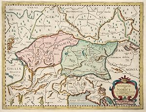
Technic: Copper print, colorit: original colored, condition: Perfect condition, size (in cm): 27 x 35, Mpa shows Vindelicia (Bavaria) ua Noricum (keltic kingdom) and Austrai with partly Slovenia.
 Altre immagini
- Rilegato
- Stampa artistica
Da: Antiquariat Lenzen, Düsseldorf, GermaniaAntiquariat Lenzen
Contatta il venditoreVenditore con 5 stelleCondizione: Usato - Ottimo
EUR 290,00
EUR 65,00 spedizioneSpedito da Germania a U.S.A.Quantità: 1 disponibili
Condizione: Sehr gut. (Philipp Clüver, latinisiert Philippus Cluverius, geboren 1580 in Danzig, gestorben am 31. Dezember 1622 in Leiden. Deutscher Geograph und Historiker, gilt als Begründer der historischen Geographie). Zwei Original-Kupferstiche, handkoloriert, von 1659 bzw. 1661 aus :"Introductionis in Universam Geographicam…", herausgegeben durch Elzevier, Amsterdam. Professionell hinter Glas/Passepartout im vergoldeten Holzrahmen gerahmt. Nicht ausgerahmt. Maße Rahmen: 25,0 x 43,0 cm. Maße Abbildungen: jeweils 12,0 x 12,5 cm. Sehr guter Zustand. Two original copperplate engravings, hand-colored, from 1659 and 1661, respectively, from "Introductionis in Universam Geographicam," published by Elzevier, Amsterdam. Professionally framed behind glass/mounted in a gilded wooden frame. Not examined out of frame. Frame dimensions: 25.0 x 43.0 cm. Illustration dimensions: each 12.0 x 12.5 cm. Very good condition.
Editore: Artist: Cluverus (Clüver) Philipp ( - 1622 ) Leiden ca : 1631, 1580
Da: Antique Sommer& Sapunaru KG, München, GermaniaAntique Sommer& Sapunaru KG
Contatta il venditoreVenditore con 4 stelleCondizione: Usato
EUR 480,00
EUR 45,00 spedizioneSpedito da Germania a U.S.A.Quantità: 1 disponibili
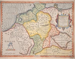
Technic: Copper print, colorit: original colored, condition: Very good, size (in cm): 26,5 x 35 cm, Map shows Germany between the Rhine and the Elbe with a title cartouche and a mileage scale. Engraved by Nicol. Geilkerckig.
 Altre immagini
Editore: Buggel und Seitz, Nuremberg, 1733
Da: Librairie La Jument Verte, Strasbourg, FranciaLibrairie La Jument Verte
Contatta il venditoreVenditore con 5 stelleMembro dell’associazione: ILAB
Condizione: Usato
EUR 2800,00
EUR 24,00 spedizioneSpedito da Francia a U.S.A.Quantità: 1 disponibili
Epitome geographiae Cluverianae nova, oder Gründlich-deutliche Beschreibung des gantzen Welt-Kreyßes und dessen vier Haupt-Theile, welche nicht allein von allen darinnen befindlichen Ländern, Königreichen, Städten, Schlössern, Insuln, Bergen, Wäldern und Flüssen, etc. ausführliche Geographische, sondern auch, nebst vielen andern… sehens-würdigen Dingen.Avec l'appendice :Geographia generalis seu mathematica, oder Gründliche Beschreibung der Erd-Kugel.Nuremberg, Buggel und Seitz, 1733. 2 titres dans 1 fort volume in-8 de (1) f. de frontispice + (1) f. de titre + (4) ff. de privilège et préface + 700 pp.+ (6) ff. de planches + (62) ff. de registre ; (1) f. de titre + 88 ff.+ (3) ff.+ (12) planches. Format de la reliure : 17 x 11 cmPlein veau moucheté marron, dos à nerfs orné de caissons et fleurons dorés, pièces de titre tabac, dentelle dorée sur les coupes, tranches jaspées. Reliure de l'époque. Quelques rousseurs légères, un manque de cuir en coiffe supérieure au niveau du tranchefile, un travail de vers dans la partie inférieure de la dernière garde impactant la garde blanche et les marges des trois derniers feuillets. Fine galerie de vers sur la coupe inférieure du dernier plat et à proximité de la coiffe inférieure du dos. Le texte principal qui décrit tous les pays du monde est du géographe originaire de Dantzig (Allemagne) Philipp Clüver (1580-1622). Publié à titre posthume, cet ouvrage est le plus important de Philipp Cluver. Cet ouvrage parut pour la première fois en 1624 sans cartes, mais la présente édition comprend de magnifiques cartes gravées. Édition allemande de l'"Introductionis in universam géographiam" parue pour la première fois en 1678 sous le titre "Anweisung zu der Geographia oder Beschreibung des Erdbodens" imprimée à Nuremberg chez Loschge (VD17 27:750198P). L'"Introductionis" est restée un ouvrage de référence jusqu'au milieu du XVIIe siècle. Il servit de base à l'enseignement de la géographie à travers de nombreuses éditions et révisions au cours du XVIIe et du XVIIIe siècle. L'illustration de la première partie se compose d'un frontispice et de 5 planches en coloris de l'époque avec des subtils rehauts à l'or sur certains détails comme les étoffes et tenues des personnages représentés. La première partie contient cinq cartes dépliantes de l'Europe (p. 1), l'Allemagne (p. 228), de l'Asie (p.513), de l'Afrique (p. 603) et de l'Amérique (p. 640). La carte de l'Amérique représente curieusement la Californie comme une île, séparée du continent. Une planche dépliante p. 230 (tableau)La seconde partie contient douze planches hors-texte toutes en couleurs, dont neuf sont dépliantes et avec trois tableaux. Notons, la belle carte du monde "Orbis Terrarum Typus" avec les deux hémisphères (p. 1), ainsi qu'une carte de la Franconie (p. 78). Un bel exemplaire complet et en bon état, où toutes les planches sont présentées dans leurs magnifiques couleurs d'origine avec des éléments dorés. Brunet VI, 19607 ; Jantz 750 ; VD18 11004681.
 Altre immagini
Editore: Amstelodami, Apud Joannem Jansonium,, 1652
- Mappa
Da: Libreria Antiquaria Dentis (ALAI - ILAB), Torino, TO, ItaliaLibreria Antiquaria Dentis (ALAI - ILAB)
Contatta il venditoreVenditore con 5 stelleCondizione: Usato - Quasi ottimo
EUR 700,00
EUR 25,00 spedizioneSpedito da Italia a U.S.A.Quantità: 1 disponibili
senza rilegatura. Condizione: quasi ottimo. Amstelodami, Apud Joannem Jansonium, 1652 ca. Incisione originale all' acquaforte rialzata a mano all' epoca ad acquarello in fine coloritura. Dimensioni: il foglio 53,3 cm x 41,4 cm, linea di cornice 50 cm x 38 cm. In basso a destra, entro cartiglio, troviamo l' elenco degli autori gr…eci e latini consultati dal Cluverio. L' autore nella carta combina lo studio delle fonti classiche con le conoscenze empiriche per rappresentare l' Italia tutta secondo la prospettiva della geografia storica: dalle Alpi alla Calabria, con Dalmazia e Corsica, le isole Eolie, parte della Sicilia e la Sardegna intera. Esemplare in ottimo stato di conservazione. L' autore, umanista e geografo tedesco di Danzica, è noto anche con il nome italianizzato in Filippo Cluverio, è considerato tra i fondatori della geografia storica, combinando metodi letterari e empirici: in particolare, fu il primo a descrivere e illustrare i siti antichi integrando all' attento studio delle fonti letterarie, epigrafiche, archeologiche e toponomastiche, sempre modernamente elencate in apertura dei suoi volumi, le osservazioni praticate fatte direttamente sul terreno durante i suoi viaggi di perlustrazione. Il Cluverio ha il merito di avere per primo dimostrato come la ricostruzione delle condizioni geografiche di età passate non sia possibile senza l' osservazione diretta delle condizioni presenti. Gli studiosi anteriori di questa disciplina, come Giacomo Gastaldi e il fiammingo Abramo Ortelio, avevano fatto essenzialmente opera da umanisti, studiando esclusivamente i testi classici, i documenti epigrafici e storici piuttosto che sull' osservazione diretta o sulla ricerca scientifica di discipline come la geografia storica. Il loro lavoro era basato su un approccio filologico e umanistico, tipico dell'epoca rinascimentale, che prediligeva la riscoperta e l'interpretazione di testi classici senza però includere l' analisi diretta dei fenomeni geografici o l' uso di metodi scientifici di indagine; crea un contrasto con un approccio più moderno che non si limita ai testi, ma che verrà poi sviluppato da studiosi successivi, come Cluverio.
 Altre immagini
Editore: Wolfenbüttel, Caspar Johann Bismarck for Conrad Buno, 1686., 1686
Da: Bernard Quaritch Ltd ABA ILAB, London, Regno UnitoBernard Quaritch Ltd ABA ILAB
Contatta il venditoreVenditore con 5 stelleCondizione: Usato
EUR 3005,95
EUR 37,36 spedizioneSpedito da Regno Unito a U.S.A.Quantità: 1 disponibili
4to, pp.[28], 607, [101 (index)], [31 (index)]; with engraved frontispiece, title-page in red and black, woodcut head- and tailpieces, 47 maps and diagrams of which 30 are folded; some dampstaining and browning, fraying to edges of one map; very good in contemporary stiff vellum with later gilt-lettered spine label, yapp edges,…edges speckled blue; some marks to spine and covers; with ownership inscription to title 'sum ex libris Friderici Ludovici iam auctionis jure MB 1699' (see below).The 1686 edition of perhaps the most important geographical textbook of the early modern period, an introduction to global geography by the German antiquarian and geographical pioneer Philipp Clüver, enlarged and supplemented by the German geographer Johann Buno. A former student of the great chronologist and classical scholar Joseph Scaliger at Leiden, Clüver began publishing on geography in 1611 with a study of the ancient Rhine region, before going on to publish works on ancient Sicily, Sardinia, and Italy. In many ways, Clüver was a typical and erudite example of that particular breed of polymath who came to define the scholarly world of the early modern Republic of Letters. His primary interest lay in reconstructing the geography of antiquity, combining personal travel and observation with a close reading of the ancients, which consequently required both the skill of the geographer and the expertise of the antiquarian and philologist. The Introductio in universam geographiam, his most complete introduction to world geography, was largely intended as a guide for students and became the standard geographical reference work of the period. It begins with a discussion of basic, universal, geographical features mountains, bodies of water, climate, and so forth before devoting individual books to the geography of various nations. The majority of the work, books two through to four, covers Europe, subdivided into regions and countries and stretching from Portugal in the south west to Moscow in the north east; book five is devoted to Asia, including India, Central Asia, Persia, the Middle East, and the western border of China; while book six covers the known parts of Africa which is to say, predominantly Egypt, Ethiopia, and Mediterranean North Africa as well as North and South America, if rather cursorily. The first edition of Clüver's work was published by Elzevir in Leiden in 1624 and was much reprinted in a number of different versions and formats in the following decades. This present copy was published in 1686 and is the work of the publisher Conrad Buno and the printer Caspar Johann Bismarck, both of whom had already collaborated on the first Wolfenbüttel edition of 1661. Just like earlier German editions, this edition contains a version of Clüver's text edited and supplemented by the German schoolteacher Johann Buno, a professor of geography and history in Luneburg and brother of Conrad. As a result, the text is far more extensive and detailed than earlier editions (the Leiden first edition ran to less than 250 pages). This copy also contains the full set of almost fifty engraved maps, which are often missing or only partially present in other existing copies. Provenance: perhaps the poet and diplomat Friedrich Ludwig von Canitz (16541699). The Biblioteca Caniziana was auctioned in February 1700. Language: Latin.
Editore: Lugdunum Batavorum (Leiden), Ludovicus Elzevirus, 1616., 1616
Da: Peter Bichsel Fine Books, Zürich, SvizzeraPeter Bichsel Fine Books
Contatta il venditoreVenditore con 4 stelleCondizione: Usato
EUR 2200,00
EUR 40,00 spedizioneSpedito da Svizzera a U.S.A.Quantità: 1 disponibili
Mit gest. Autorporträt, gest. Titelblatt, 11 doppelblattgrossen Karten in Kupferstich und 26 Kupfertafeln. 21 Bll., 400 SS., 203 SS., 230 SS., 36 SS., 9 Bll. Register. Folio. Pgt. d. Zt. über 5 Bünden mit goldgepr. Deckelzier. Erste Ausgabe. Philipp Clüvers (15801622) Hauptwerk zur Geographie und Ethnographie Germaniens, in dem…er sich auf Autoren wie Tacitus, Caesar, Ptolemaeus, Strabo und viele andere mehr abstützt. Teil I befasst sich mit der geographischen Lage und den Sitten Germaniens schlechthin, Teil II mit der Germania Cisrhenana", während Teil III die Germania Transrhenana" abhandelt. Die enthaltenen, ganzseitigen Kupfertafeln zeigen Menschen im häuslichen und kriegerischen Umfeld und festigten über lange Zeit die ikonographische Vorstellung der alten Germanen". Die elf Karten zeichnen ein detailliertes Bild der Volksstämme und Flussläufe nach. Kopfsteg zu Beginn und gegen den Schluss etwas feuchtigkeitsrandig. Einband etwas fleckig, vorderes Aussengelenk von unten her ein Stück weit aufgerissen. Schliessbänder fehlen. Insgesamt noch gutes Exemplar im zeitgenössischen Einband.


